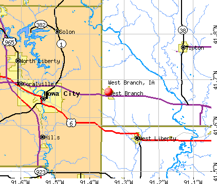
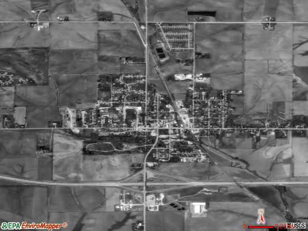
West Branch, Iowa
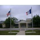
West Branch: Herbert Hoover Museum and Library
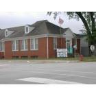
West Branch: Municiple building

West Branch: Herbert Hoover Grave site
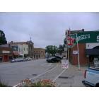
West Branch: Downtown
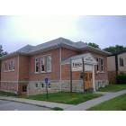
West Branch: Newspaper building downtown
- add
your


Submit your own pictures of this city and show them to the world
- OSM Map
- General Map
- Google Map
- MSN Map
Population change since 2000: +21.3%
 |
| Males: 1,309 | |
| Females: 1,344 |
| Median resident age: | 35.9 years |
| Iowa median age: | 38.9 years |
Zip codes: 52358.
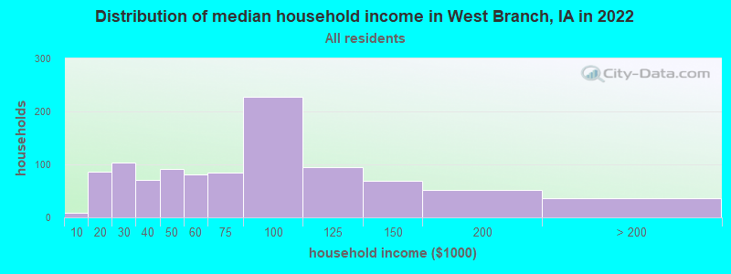
| West Branch: | $71,922 |
| IA: | $69,588 |
Estimated per capita income in 2022: $33,829 (it was $19,577 in 2000)
West Branch city income, earnings, and wages data
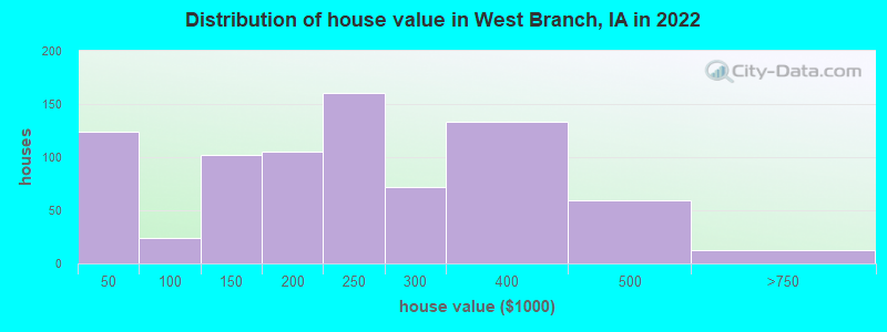
Estimated median house or condo value in 2022: $219,675 (it was $88,900 in 2000)
| West Branch: | $219,675 |
| IA: | $194,600 |
Mean prices in 2022: all housing units: $213,918; detached houses: $269,161; townhouses or other attached units: $178,153; in 5-or-more-unit structures: $87,224; mobile homes: $15,421
Median gross rent in 2022: $883.
(14.7% for White Non-Hispanic residents, 1.6% for two or more races residents)
Detailed information about poverty and poor residents in West Branch, IA
Compare current foreclosures near West Branch, IA:
| Photo | Address | Area | Beds / Baths | Price | Details |
|---|---|---|---|---|---|

|
#1
Eisenhower St
West Branch, IA 52358
|
- sq. feet
|
- baths - beds |
show details | |

|
#2
Broadway St
Nichols, IA 52766
|
1,330 sq. feet
|
1 baths 3 beds |
show details | |

|
#3
Sutliff 2nd NE
Lisbon, IA 52253
|
1,352 sq. feet
|
2 baths 3 beds |
show details | |

|
#4
Forest Edge Dr
Coralville, IA 52241
|
2,406 sq. feet
|
3 baths 3 beds |
show details | |

|
#5
W 2nd St
Tipton, IA 52772
|
1,575 sq. feet
|
1 baths 4 beds |
show details | |

|
#6
Locust St
Tipton, IA 52772
|
1,953 sq. feet
|
1 baths 3 beds |
show details | |

|
#7
E 2nd St
Tipton, IA 52772
|
937 sq. feet
|
1 baths 2 beds |
show details | |

|
#8
E 4th St
Tipton, IA 52772
|
1,596 sq. feet
|
1 baths 3 beds |
show details | |

|
#9
E 7th St
Tipton, IA 52772
|
1,732 sq. feet
|
1 baths 4 beds |
show details | |

|
#10
E Grantview Dr
Coralville, IA 52241
|
1,687 sq. feet
|
4 baths 4 beds |
show details |
| Photo | Address | Area | Beds / Baths | Price | Details |
|---|---|---|---|---|---|

|
#11
Lencester Ave
North Liberty, IA 52317
|
1,256 sq. feet
|
3 baths 4 beds |
show details | |

|
#12
Crest View Rd NE
Solon, IA 52333
|
3,513 sq. feet
|
5 baths 4 beds |
show details | |

|
#13
Coral Ct Apt 104
Coralville, IA 52241
|
910 sq. feet
|
1 baths 2 beds |
show details | |

|
#14
Newberry Ave NE
Solon, IA 52333
|
1,564 sq. feet
|
3 baths 4 beds |
show details | |

|
#15
S Park Ridge Rd
North Liberty, IA 52317
|
1,426 sq. feet
|
4 baths 3 beds |
show details | |

|
#16
Kimberlite St
Tiffin, IA 52340
|
1,235 sq. feet
|
2 baths 3 beds |
show details | |

|
#17
Holiday Rd Apt 3
Coralville, IA 52241
|
2,275 sq. feet
|
3 baths 4 beds |
show details | |

|
#18
14th Ave
Coralville, IA 52241
|
1,120 sq. feet
|
1 baths 3 beds |
show details | |

|
#19
290th St
Atalissa, IA 52720
|
982 sq. feet
|
1 baths 3 beds |
show details | |

|
#20
N Miller St
West Liberty, IA 52776
|
1,602 sq. feet
|
1 baths 4 beds |
show details |
| Photo | Address | Area | Beds / Baths | Price | Details |
|---|---|---|---|---|---|

|
#21
2nd Ave
Iowa City, IA 52240
|
925 sq. feet
|
- baths 7 beds |
show details | |

|
#22
Gleason Dr
Iowa City, IA 52240
|
1,326 sq. feet
|
- baths 8 beds |
show details | |

|
#23
Lexington Ave
Iowa City, IA 52246
|
2,508 sq. feet
|
- baths 8 beds |
show details | |

|
#24
Regal Ln
Iowa City, IA 52240
|
913 sq. feet
|
- baths 6 beds |
show details | |

|
#25
Grantwood St
Iowa City, IA 52240
|
1,040 sq. feet
|
- baths 6 beds |
show details | |

|
#26
Broadway St
Iowa City, IA 52240
|
1,288 sq. feet
|
- baths 7 beds |
show details | |

|
#27
Hollywood Ct
Iowa City, IA 52240
|
828 sq. feet
|
- baths 5 beds |
show details | |

|
#28
Hemingway Ln
Iowa City, IA 52240
|
1,656 sq. feet
|
- baths 9 beds |
show details | |

|
#29
Spruce St
Iowa City, IA 52240
|
936 sq. feet
|
- baths 6 beds |
show details | |

|
#30
Burr Dr
North Liberty, IA 52317
|
1,577 sq. feet
|
- baths - beds |
show details |
| Photo | Address | Area | Beds / Baths | Price | Details |
|---|---|---|---|---|---|

|
#31
Hawkeye Dr Apt 203
North Liberty, IA 52317
|
- sq. feet
|
- baths - beds |
show details | |

|
#32
Washington Ave Unit 1
North Liberty, IA 52317
|
- sq. feet
|
- baths - beds |
show details | |

|
#33
Hancock St
North Liberty, IA 52317
|
- sq. feet
|
- baths - beds |
show details | |

|
#34
2nd St Trlr 66
Coralville, IA 52241
|
- sq. feet
|
- baths - beds |
show details | |

|
#35
Cambria Dr
North Liberty, IA 52317
|
- sq. feet
|
- baths - beds |
show details | |

|
#36
Ivanhoe Rd
Mount Vernon, IA 52314
|
- sq. feet
|
- baths - beds |
show details | |

|
#37
N Sunset Dr
North Liberty, IA 52317
|
- sq. feet
|
- baths - beds |
show details | |

|
#38
Walnut Ave Unit 109c
Riverside, IA 52327
|
- sq. feet
|
- baths - beds |
show details | |

|
#39
Scott Park Dr Apt 203
Iowa City, IA 52245
|
- sq. feet
|
- baths - beds |
show details | |

|
#40
Alexander Way Unit 204
North Liberty, IA 52317
|
- sq. feet
|
- baths - beds |
show details |
| Photo | Address | Area | Beds / Baths | Price | Details |
|---|---|---|---|---|---|

|
#41
Rolling Hills Dr
Tiffin, IA 52340
|
- sq. feet
|
- baths - beds |
show details | |

|
#42
Unbridled Ave
Iowa City, IA 52240
|
- sq. feet
|
- baths - beds |
show details | |

|
#43
Calla Lilly Way
Tiffin, IA 52340
|
- sq. feet
|
- baths - beds |
show details | |

|
#44
Bear Dr
Tiffin, IA 52340
|
1,597 sq. feet
|
- baths - beds |
show details | |

|
#45
Village Dr # 7
Tiffin, IA 52340
|
- sq. feet
|
- baths - beds |
show details | |

|
#46
Stanford Ave
Iowa City, IA 52245
|
- sq. feet
|
- baths - beds |
show details | |

|
#47
Apple Ct
Iowa City, IA 52240
|
- sq. feet
|
- baths - beds |
show details | |

|
#48
1st Ave Apt C-205n
Coralville, IA 52241
|
- sq. feet
|
- baths - beds |
show details | |

|
#49
Nicholas Ln
North Liberty, IA 52317
|
1,460 sq. feet
|
- baths - beds |
show details | |

|
Check over 1 million property listings on Foreclosure.com!
|
browse all offers | |||


- 2,28190.8%White alone
- 1024.1%Hispanic
- 602.4%Two or more races
- 271.1%Black alone
- 261.0%Asian alone

Races in West Branch detailed stats: ancestries, foreign born residents, place of birth
According to our research of Iowa and other state lists, there were 4 registered sex offenders living in West Branch, Iowa as of April 19, 2024.
The ratio of all residents to sex offenders in West Branch is 651 to 1.
The ratio of registered sex offenders to all residents in this city is lower than the state average.
Type |
2010 |
2011 |
2012 |
2014 |
2015 |
2016 |
2017 |
2019 |
2020 |
2021 |
2022 |
|---|---|---|---|---|---|---|---|---|---|---|---|
| Murders (per 100,000) | 0 (0.0) | 0 (0.0) | 0 (0.0) | 0 (0.0) | 0 (0.0) | 0 (0.0) | 0 (0.0) | 0 (0.0) | 0 (0.0) | 0 (0.0) | 0 (0.0) |
| Rapes (per 100,000) | 0 (0.0) | 0 (0.0) | 0 (0.0) | 0 (0.0) | 1 (42.5) | 1 (42.7) | 0 (0.0) | 0 (0.0) | 0 (0.0) | 2 (78.8) | 0 (0.0) |
| Robberies (per 100,000) | 1 (44.9) | 0 (0.0) | 0 (0.0) | 0 (0.0) | 0 (0.0) | 0 (0.0) | 0 (0.0) | 0 (0.0) | 0 (0.0) | 0 (0.0) | 0 (0.0) |
| Assaults (per 100,000) | 0 (0.0) | 0 (0.0) | 0 (0.0) | 1 (43.0) | 3 (127.4) | 6 (256.4) | 5 (211.4) | 1 (41.0) | 0 (0.0) | 3 (118.2) | 0 (0.0) |
| Burglaries (per 100,000) | 5 (224.5) | 4 (171.4) | 0 (0.0) | 0 (0.0) | 0 (0.0) | 2 (85.5) | 2 (84.6) | 0 (0.0) | 2 (79.7) | 3 (118.2) | 3 (115.0) |
| Thefts (per 100,000) | 4 (179.6) | 4 (171.4) | 1 (43.1) | 3 (129.0) | 3 (127.4) | 7 (299.1) | 2 (84.6) | 4 (164.0) | 5 (199.2) | 8 (315.1) | 9 (345.1) |
| Auto thefts (per 100,000) | 0 (0.0) | 0 (0.0) | 0 (0.0) | 0 (0.0) | 0 (0.0) | 1 (42.7) | 1 (42.3) | 0 (0.0) | 2 (79.7) | 0 (0.0) | 1 (38.3) |
| Arson (per 100,000) | 0 (0.0) | 1 (42.8) | 0 (0.0) | 0 (0.0) | 0 (0.0) | 0 (0.0) | 0 (0.0) | 0 (0.0) | 0 (0.0) | 0 (0.0) | 1 (38.3) |
| City-Data.com crime index | 36.4 | 18.9 | 1.7 | 13.8 | 64.5 | 106.8 | 55.0 | 14.8 | 19.9 | 107.5 | 24.9 |
The City-Data.com crime index weighs serious crimes and violent crimes more heavily. Higher means more crime, U.S. average is 246.1. It adjusts for the number of visitors and daily workers commuting into cities.
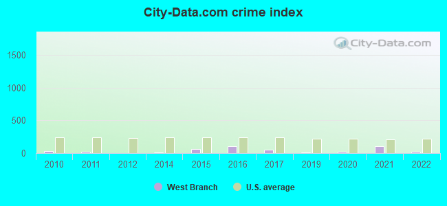
Crime rate in West Branch detailed stats: murders, rapes, robberies, assaults, burglaries, thefts, arson
Full-time law enforcement employees in 2021, including police officers: 4 (4 officers - 3 male; 1 female).
| Officers per 1,000 residents here: | 1.58 |
| Iowa average: | 1.76 |
 Recent articles from our blog. Our writers, many of them Ph.D. graduates or candidates, create easy-to-read articles on a wide variety of topics.


 | Driving I-80 across Iowa question (34 replies) |
| Move to eastern Iowa? Opinions on Cedar County / Tipton? (9 replies) |
| What's it like in Iowa for liberal retirees? (31 replies) |
| Dream town in Iowa (34 replies) |
| Small towns near Coralville (8 replies) |
| Relocating to Iowa City next year (3 replies) |
Latest news from West Branch, IA collected exclusively by city-data.com from local newspapers, TV, and radio stations
Ancestries: German (33.3%), American (14.2%), English (9.1%), Irish (6.3%), Norwegian (2.8%), Danish (2.6%).
Current Local Time: CST time zone
Incorporated on 04/12/1875
Elevation: 750 feet
Land area: 1.98 square miles.
Population density: 1,342 people per square mile (low).

17 residents are foreign born
| This city: | 0.7% |
| Iowa: | 5.6% |
| West Branch city: | 1.5% ($1,321) |
| Iowa: | 1.3% ($1,077) |
Nearest city with pop. 50,000+: Iowa City, IA  (9.3 miles , pop. 62,220).
Nearest city with pop. 200,000+: Madison, WI (139.0 miles , pop. 208,054).
Nearest city with pop. 1,000,000+: Chicago, IL (189.5 miles , pop. 2,896,016).
Nearest cities:
), ), ), )Latitude: 41.67 N, Longitude: 91.35 W
Area code: 319
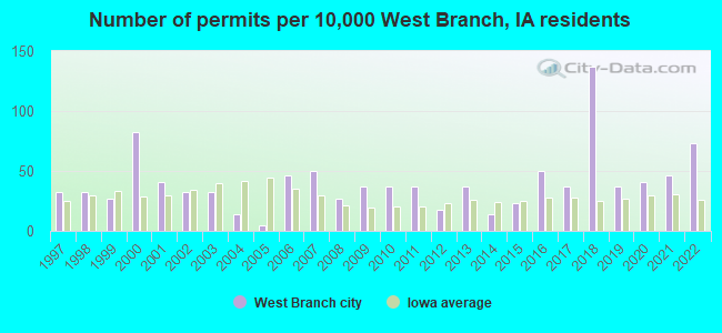
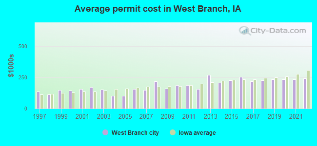
Single-family new house construction building permits:
- 2022: 16 buildings, average cost: $241,100
- 2021: 10 buildings, average cost: $234,000
- 2020: 9 buildings, average cost: $234,000
- 2019: 8 buildings, average cost: $234,000
- 2018: 30 buildings, average cost: $226,700
- 2017: 8 buildings, average cost: $217,000
- 2016: 11 buildings, average cost: $253,900
- 2015: 5 buildings, average cost: $225,100
- 2014: 3 buildings, average cost: $205,500
- 2013: 8 buildings, average cost: $269,300
- 2012: 4 buildings, average cost: $156,900
- 2011: 8 buildings, average cost: $189,400
- 2010: 8 buildings, average cost: $189,400
- 2009: 8 buildings, average cost: $160,800
- 2008: 6 buildings, average cost: $218,700
- 2007: 11 buildings, average cost: $148,200
- 2006: 10 buildings, average cost: $156,300
- 2005: 1 building, cost: $100,000
- 2004: 3 buildings, average cost: $103,200
- 2003: 7 buildings, average cost: $152,700
- 2002: 7 buildings, average cost: $171,400
- 2001: 9 buildings, average cost: $158,300
- 2000: 18 buildings, average cost: $145,600
- 1999: 6 buildings, average cost: $150,000
- 1998: 7 buildings, average cost: $114,300
- 1997: 7 buildings, average cost: $134,900
| Here: | 2.7% |
| Iowa: | 2.7% |
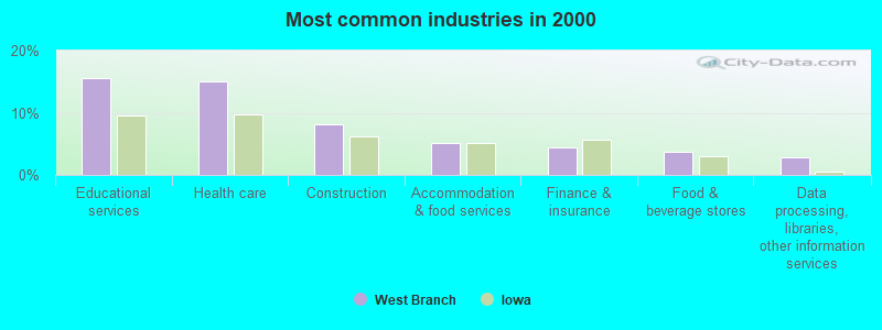
- Educational services (15.6%)
- Health care (15.1%)
- Construction (8.1%)
- Accommodation & food services (5.1%)
- Finance & insurance (4.4%)
- Food & beverage stores (3.7%)
- Data processing, libraries, other information services (2.9%)
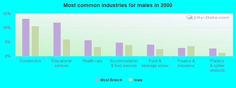
- Construction (13.3%)
- Educational services (11.8%)
- Health care (5.7%)
- Accommodation & food services (4.9%)
- Food & beverage stores (4.1%)
- Finance & insurance (3.0%)
- Plastics & rubber products (2.8%)
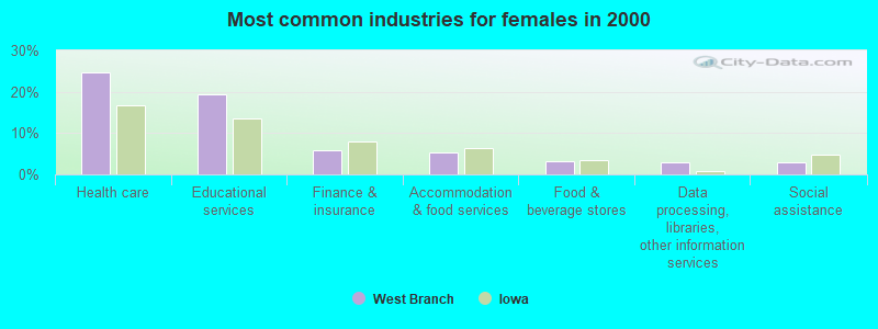
- Health care (24.7%)
- Educational services (19.4%)
- Finance & insurance (5.8%)
- Accommodation & food services (5.3%)
- Food & beverage stores (3.2%)
- Data processing, libraries, other information services (3.0%)
- Social assistance (3.0%)
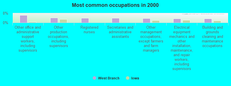
- Other office and administrative support workers, including supervisors (6.3%)
- Other production occupations, including supervisors (4.2%)
- Registered nurses (4.0%)
- Secretaries and administrative assistants (3.8%)
- Other management occupations, except farmers and farm managers (3.6%)
- Electrical equipment mechanics and other installation, maintenance, and repair workers, including supervisors (3.5%)
- Building and grounds cleaning and maintenance occupations (3.3%)
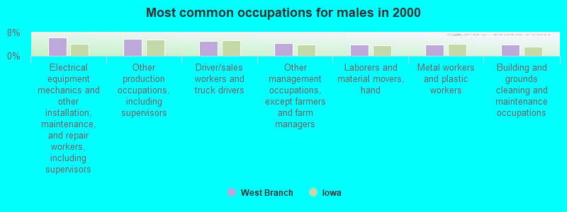
- Electrical equipment mechanics and other installation, maintenance, and repair workers, including supervisors (6.3%)
- Other production occupations, including supervisors (5.8%)
- Driver/sales workers and truck drivers (5.1%)
- Other management occupations, except farmers and farm managers (4.3%)
- Laborers and material movers, hand (3.9%)
- Metal workers and plastic workers (3.9%)
- Building and grounds cleaning and maintenance occupations (3.9%)
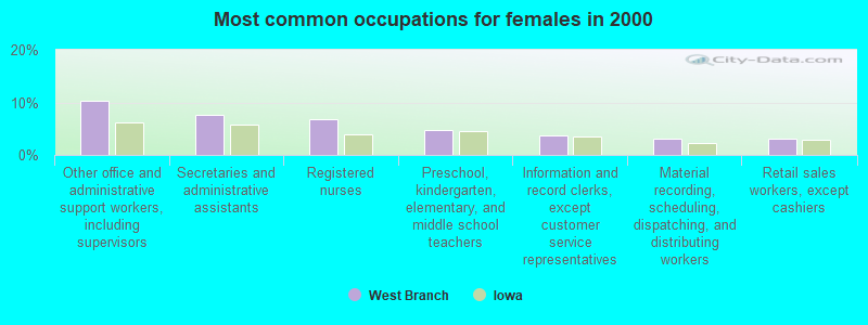
- Other office and administrative support workers, including supervisors (10.3%)
- Secretaries and administrative assistants (7.7%)
- Registered nurses (6.9%)
- Preschool, kindergarten, elementary, and middle school teachers (4.7%)
- Information and record clerks, except customer service representatives (3.7%)
- Material recording, scheduling, dispatching, and distributing workers (3.0%)
- Retail sales workers, except cashiers (3.0%)
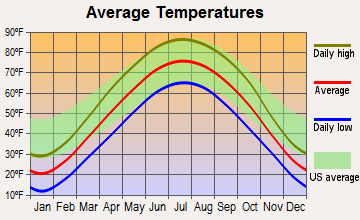
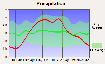
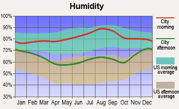
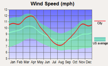
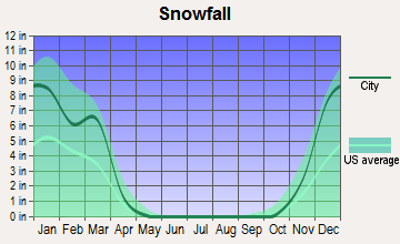
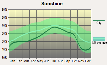
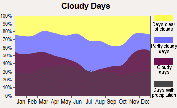
Average climate in West Branch, Iowa
Based on data reported by over 4,000 weather stations
|
|

(lower is better)
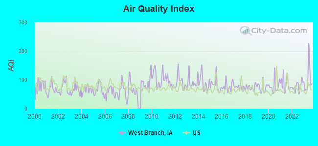
Air Quality Index (AQI) level in 2023 was 103. This is significantly worse than average.
| City: | 103 |
| U.S.: | 73 |
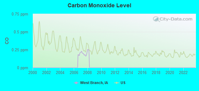
Carbon Monoxide (CO) [ppm] level in 2007 was 0.195. This is better than average. Closest monitor was 23.8 miles away from the city center.
| City: | 0.195 |
| U.S.: | 0.251 |
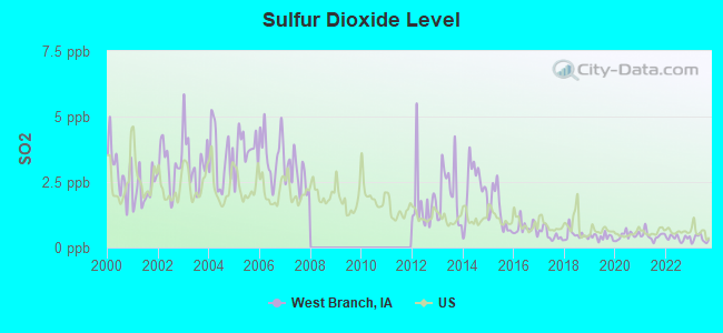
Sulfur Dioxide (SO2) [ppb] level in 2023 was 0.326. This is significantly better than average. Closest monitor was 10.5 miles away from the city center.
| City: | 0.326 |
| U.S.: | 1.515 |
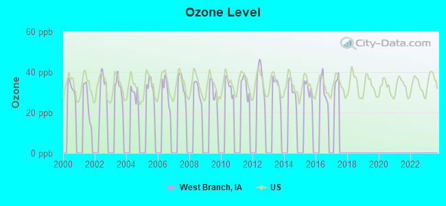
Ozone [ppb] level in 2016 was 31.4. This is about average. Closest monitor was 13.6 miles away from the city center.
| City: | 31.4 |
| U.S.: | 33.3 |
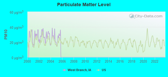
Particulate Matter (PM10) [µg/m3] level in 2005 was 25.3. This is worse than average. Closest monitor was 8.2 miles away from the city center.
| City: | 25.3 |
| U.S.: | 19.2 |
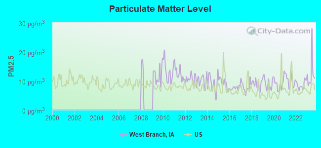
Particulate Matter (PM2.5) [µg/m3] level in 2023 was 12.4. This is significantly worse than average. Closest monitor was 8.2 miles away from the city center.
| City: | 12.4 |
| U.S.: | 8.1 |
Tornado activity:
West Branch-area historical tornado activity is near Iowa state average. It is 93% greater than the overall U.S. average.
On 4/11/1965, a category F4 (max. wind speeds 207-260 mph) tornado 24.7 miles away from the West Branch city center killed one person and injured 3 people and caused between $500,000 and $5,000,000 in damages.
On 6/7/1984, a category F4 tornado 26.9 miles away from the city center killed 3 people and injured 64 people and caused between $5,000,000 and $50,000,000 in damages.
Earthquake activity:
West Branch-area historical earthquake activity is significantly above Iowa state average. It is 141% greater than the overall U.S. average.On 4/18/2008 at 09:36:59, a magnitude 5.4 (5.1 MB, 4.8 MS, 5.4 MW, 5.2 MW, Class: Moderate, Intensity: VI - VII) earthquake occurred 288.4 miles away from the city center
On 6/10/1987 at 23:48:54, a magnitude 5.1 (4.9 MB, 4.4 MS, 4.6 MS, 5.1 LG) earthquake occurred 268.8 miles away from West Branch center
On 4/18/2008 at 09:36:59, a magnitude 5.2 (5.2 MW, Depth: 8.9 mi) earthquake occurred 288.4 miles away from the city center
On 6/28/2004 at 06:10:52, a magnitude 4.2 (4.2 MW, Depth: 6.2 mi, Class: Light, Intensity: IV - V) earthquake occurred 127.4 miles away from the city center
On 6/18/2002 at 17:37:15, a magnitude 5.0 (4.3 MB, 4.6 MW, 5.0 LG) earthquake occurred 317.5 miles away from West Branch center
On 4/18/2008 at 15:14:16, a magnitude 4.8 (4.5 MB, 4.8 MW, 4.6 MW) earthquake occurred 288.4 miles away from the city center
Magnitude types: regional Lg-wave magnitude (LG), body-wave magnitude (MB), surface-wave magnitude (MS), moment magnitude (MW)
Natural disasters:
The number of natural disasters in Cedar County (16) is near the US average (15).Major Disasters (Presidential) Declared: 14
Emergencies Declared: 1
Causes of natural disasters: Floods: 11, Storms: 11, Tornadoes: 5, Winds: 2, Winter Storms: 2, Hurricane: 1, Other: 1 (Note: some incidents may be assigned to more than one category).
Hospitals and medical centers in West Branch:
Other hospitals and medical centers near West Branch:
- IOWA CITY REHAB AND HEALTH CARE (Nursing Home, about 8 miles away; IOWA CITY, IA)
- SIMPSON MEMORIAL HOME, INC (Nursing Home, about 9 miles away; WEST LIBERTY, IA)
- MERCY HOME HEALTH CARE (Home Health Center, about 9 miles away; IOWA CITY, IA)
- IOWA CITY HOSPICE (Hospital, about 9 miles away; IOWA CITY, IA)
- IOWA CITY VA MEDICAL CENTER (Hospital, Acute Care - Veterans Administration, about 9 miles away; IOWA CITY, IA)
- MERCY HOSPITAL Acute Care Hospitals (about 10 miles away; IOWA CITY, IA)
- GIRLING HEALTH CARE (Home Health Center, about 10 miles away; IOWA CITY, IA)
Colleges/universities with over 2000 students nearest to West Branch:
- University of Iowa (about 10 miles; Iowa City, IA; Full-time enrollment: 24,735)
- Kirkwood Community College (about 23 miles; Cedar Rapids, IA; FT enrollment: 11,503)
- Saint Ambrose University (about 41 miles; Davenport, IA; FT enrollment: 3,053)
- Eastern Iowa Community College District (about 42 miles; Davenport, IA; FT enrollment: 5,507)
- Kaplan University-Davenport Campus (about 42 miles; Davenport, IA; FT enrollment: 60,376)
- Augustana College (about 43 miles; Rock Island, IL; FT enrollment: 2,555)
- Black Hawk College (about 49 miles; Moline, IL; FT enrollment: 5,086)
Public high school in West Branch:
- WEST BRANCH HIGH SCHOOL (Students: 246, Location: 900 W MAIN, Grades: 9-12)
Private high school in West Branch:
- SCATTERGOOD FRIENDS SCHOOL (Students: 52, Location: 1951 DELTA AVE, Grades: 9-12)
Public elementary/middle schools in West Branch:
- WEST BRANCH MIDDLE SCHOOL (Students: 183, Location: 225 N MAPLE, Grades: 5-8)
- HOOVER ELEMENTARY SCHOOL (Location: 148 N OLIPHANT, Grades: PK-4)
Points of interest:
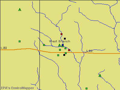
Notable locations in West Branch: Fox Run Golf and Country Club (A), Herbert Hoover Presidential Library and Museum (B), West Branch Police Department (C), West Branch Public Library (D), West Branch Fire Department (E), West Branch Heritage Museum (F). Display/hide their locations on the map
Churches in West Branch include: Bethany Lutheran Church (A), Friends Church (B), United Methodist Church (C), Saint Bernadette Catholic Church (D). Display/hide their locations on the map
Cemetery: Old Friends Cemetery (1). Display/hide its location on the map
Creek: Hoover Creek (A). Display/hide its location on the map
Parks in West Branch include: Herbert Hoover National Historic Site (1), President Herbert Hoover's Birthplace Historical Marker (2). Display/hide their locations on the map
Hotels: Best Value Inn (711 South Downey), Presidential Motor Inn (711 S Downey St).
Birthplace of: Herbert Hoover - (1874-1964), mining engineer, President of the United States, David Johnson (Iowa politician) - Politician, Marv Cook - College football player.
Drinking water stations with addresses in West Branch and their reported violations in the past:
FOUR OAKS (Address: 127 NORTH 4th ST , Population served: 60, Groundwater):Past health violations:Past monitoring violations:
- MCL, Monthly (TCR) - In JUN-2007, Contaminant: Coliform. Follow-up actions: St Compliance achieved (FEB-15-2007), St Violation/Reminder Notice (JUN-29-2007), St Public Notif requested (JUL-05-2007), St Formal NOV issued (JUL-05-2007), St Public Notif received (AUG-13-2007)
- MCL, Monthly (TCR) - In JUN-2005, Contaminant: Coliform. Follow-up actions: St Violation/Reminder Notice (JUN-13-2005), St Formal NOV issued (JUN-16-2005), St Public Notif requested (JUN-16-2005), St Compliance achieved (DEC-14-2005)
- Monitoring and Reporting (DBP) - Between APR-2005 and JUN-2005, Contaminant: Chlorine. Follow-up actions: St Compliance achieved (AUG-04-2005), St Formal NOV issued (AUG-10-2005)
- Monitoring and Reporting (DBP) - Between JAN-2005 and MAR-2005, Contaminant: Chlorine. Follow-up actions: St Formal NOV issued (MAY-02-2005), St Public Notif requested (MAY-02-2005), St Compliance achieved (2 times from JUN-01-2005 to JUN-01-2005)
| This city: | 2.4 people |
| Iowa: | 2.4 people |
| This city: | 64.6% |
| Whole state: | 64.7% |
| This city: | 9.2% |
| Whole state: | 6.7% |
Likely homosexual households (counted as self-reported same-sex unmarried-partner households)
- Lesbian couples: 0.5% of all households
- Gay men: 0.0% of all households
People in group quarters in West Branch in 2000:
- 59 people in nursing homes
- 17 people in hospitals/wards and hospices for chronically ill
- 17 people in hospices or homes for chronically ill
Banks with branches in West Branch (2011 data):
- U.S. Bank National Association: West Branch at 127 West Main Street, branch established on 1998/11/13. Info updated 2012/01/30: Bank assets: $330,470.8 mil, Deposits: $236,091.5 mil, headquarters in Cincinnati, OH, positive income, 3121 total offices, Holding Company: U.S. Bancorp
- Community State Bank: West Branch Office at 801 W. Main Street, branch established on 2007/12/03. Info updated 2008/03/18: Bank assets: $96.8 mil, Deposits: $85.6 mil, headquarters in Tipton, IA, positive income, Agricultural Specialization, 4 total offices, Holding Company: Fidelity Company
For population 15 years and over in West Branch:
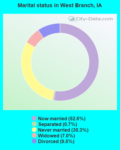
- Never married: 30.3%
- Now married: 52.6%
- Separated: 0.7%
- Widowed: 7.0%
- Divorced: 9.5%
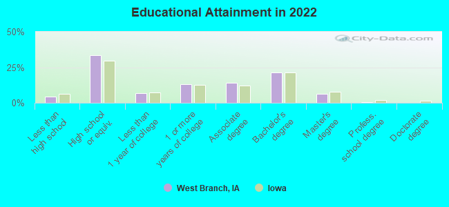
For population 25 years and over in West Branch:
- High school or higher: 95.1%
- Bachelor's degree or higher: 26.1%
- Graduate or professional degree: 6.3%
- Unemployed: 2.3%
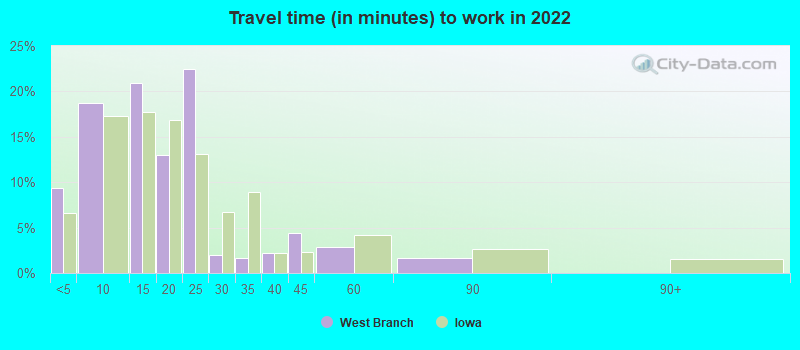
- Mean travel time to work (commute): 20.5 minutes
| Here: | 8.5 |
| Iowa average: | 10.5 |
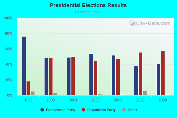
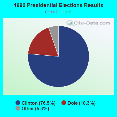
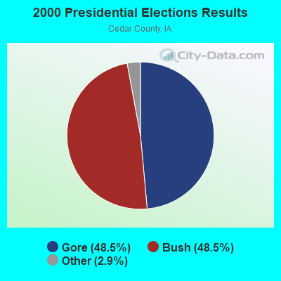

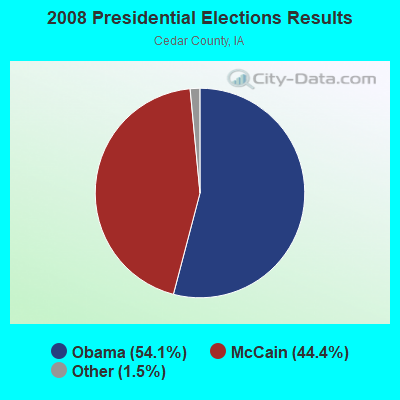
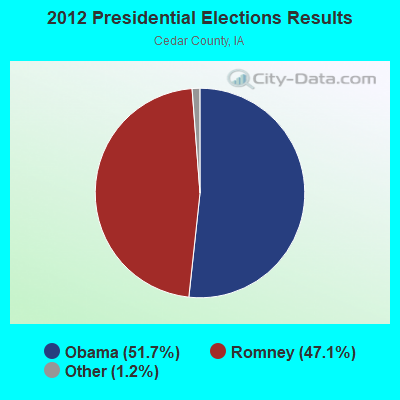

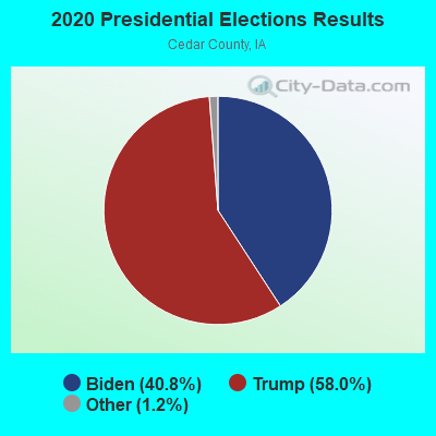
Graphs represent county-level data. Detailed 2008 Election Results
Religion statistics for West Branch, IA (based on Cedar County data)
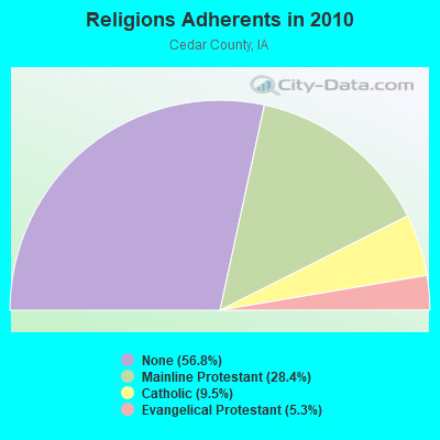
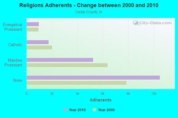
| Religion | Adherents | Congregations |
|---|---|---|
| Mainline Protestant | 5,250 | 19 |
| Catholic | 1,759 | 3 |
| Evangelical Protestant | 987 | 10 |
| Other | 4 | - |
| None | 10,499 | - |
Food Environment Statistics:
| Cedar County: | 3.34 / 10,000 pop. |
| Iowa: | 2.14 / 10,000 pop. |
| Here: | 0.56 / 10,000 pop. |
| Iowa: | 0.43 / 10,000 pop. |
| This county: | 7.24 / 10,000 pop. |
| Iowa: | 5.55 / 10,000 pop. |
| Here: | 7.79 / 10,000 pop. |
| Iowa: | 8.01 / 10,000 pop. |
| Cedar County: | 7.6% |
| State: | 7.8% |
| This county: | 27.6% |
| Iowa: | 27.3% |
| Cedar County: | 7.2% |
| Iowa: | 14.5% |
Health and Nutrition:
| West Branch: | 50.6% |
| Iowa: | 49.5% |
| West Branch: | 47.9% |
| Iowa: | 46.1% |
| West Branch: | 29.0 |
| State: | 28.6 |
| This city: | 21.8% |
| State: | 21.4% |
| West Branch: | 10.9% |
| Iowa: | 10.4% |
| Here: | 6.8 |
| Iowa: | 6.8 |
| West Branch: | 35.0% |
| State: | 33.8% |
| West Branch: | 57.8% |
| Iowa: | 55.9% |
| This city: | 78.4% |
| State: | 77.7% |
More about Health and Nutrition of West Branch, IA Residents
| Local government employment and payroll (March 2022) | |||||
| Function | Full-time employees | Monthly full-time payroll | Average yearly full-time wage | Part-time employees | Monthly part-time payroll |
|---|---|---|---|---|---|
| Streets and Highways | 5 | $23,186 | $55,646 | 1 | $29 |
| Police Protection - Officers | 4 | $21,403 | $64,209 | 0 | $0 |
| Local Libraries | 3 | $12,570 | $50,280 | 1 | $27 |
| Other Government Administration | 2 | $13,079 | $78,474 | 0 | $0 |
| Financial Administration | 1 | $4,926 | $59,112 | 0 | $0 |
| Totals for Government | 15 | $75,164 | $60,131 | 2 | $55 |
West Branch government finances - Expenditure in 2021 (per resident):
- Construction - General - Other: $188,000 ($70.86)
Regular Highways: $93,000 ($35.05)
Water Utilities: $82,000 ($30.91)
Sewerage: $27,000 ($10.18)
- Current Operations - Police Protection: $445,000 ($167.73)
Regular Highways: $393,000 ($148.13)
Water Utilities: $354,000 ($133.43)
Sewerage: $282,000 ($106.29)
Libraries: $247,000 ($93.10)
Parks and Recreation: $220,000 ($82.92)
Solid Waste Management: $196,000 ($73.88)
Local Fire Protection: $181,000 ($68.22)
Financial Administration: $150,000 ($56.54)
Miscellaneous Commercial Activities - Other: $121,000 ($45.61)
General - Other: $101,000 ($38.07)
Central Staff Services: $35,000 ($13.19)
Judicial and Legal Services: $26,000 ($9.80)
Public Welfare - Other: $25,000 ($9.42)
Protective Inspection and Regulation - Other: $18,000 ($6.78)
Health - Other: $1,000 ($0.38)
- General - Interest on Debt: $281,000 ($105.92)
- Total Salaries and Wages: $1,124,000 ($423.67)
West Branch government finances - Revenue in 2021 (per resident):
- Charges - Sewerage: $699,000 ($263.48)
Solid Waste Management: $176,000 ($66.34)
Other: $51,000 ($19.22)
Parks and Recreation: $15,000 ($5.65)
Miscellaneous Commercial Activities: $9,000 ($3.39)
- Federal Intergovernmental - Other: $144,000 ($54.28)
Housing and Community Development: $25,000 ($9.42)
- Local Intergovernmental - Other: $207,000 ($78.02)
- Miscellaneous - General Revenue - Other: $102,000 ($38.45)
Sale of Property: $91,000 ($34.30)
Interest Earnings: $24,000 ($9.05)
Rents: $2,000 ($0.75)
Fines and Forfeits: $2,000 ($0.75)
- Revenue - Water Utilities: $594,000 ($223.90)
- State Intergovernmental - Highways: $348,000 ($131.17)
General Local Government Support: $95,000 ($35.81)
Other: $9,000 ($3.39)
- Tax - Property: $2,403,000 ($905.77)
General Sales and Gross Receipts: $266,000 ($100.26)
Other License: $51,000 ($19.22)
Public Utilities Sales: $36,000 ($13.57)
Other Selective Sales: $35,000 ($13.19)
West Branch government finances - Debt in 2021 (per resident):
- Long Term Debt - Beginning Outstanding - Unspecified Public Purpose: $7,015,000 ($2644.18)
Outstanding Unspecified Public Purpose: $6,118,000 ($2306.07)
Retired Unspecified Public Purpose: $897,000 ($338.11)
West Branch government finances - Cash and Securities in 2021 (per resident):
- Other Funds - Cash and Securities: $4,691,000 ($1768.19)
| Businesses in West Branch, IA | ||||
| Name | Count | Name | Count | |
|---|---|---|---|---|
| Ford | 1 | Quiznos | 1 | |
| McDonald's | 1 | U-Haul | 1 | |
Strongest AM radio stations in West Branch:
- KCJJ (1630 AM; 10 kW; IOWA CITY, IA; Owner: RIVER CITY RADIO, INC.)
- WSUI (910 AM; 5 kW; IOWA CITY, IA; Owner: THE UNIVERSITY OF IOWA)
- KXIC (800 AM; 1 kW; IOWA CITY, IA; Owner: CITICASTERS LICENSES, L.P.)
- WMT (600 AM; 5 kW; CEDAR RAPIDS, IA; Owner: CITICASTERS LICENSES, L.P.)
- KXEL (1540 AM; 50 kW; WATERLOO, IA; Owner: KXEL BROADCASTING COMPANY, INC.)
- KCRG (1600 AM; 5 kW; CEDAR RAPIDS, IA; Owner: CEDAR RAPIDS TELEVISION CO.)
- WHO (1040 AM; 50 kW; DES MOINES, IA; Owner: CITICASTERS LICENSES, L.P.)
- WSCR (670 AM; 50 kW; CHICAGO, IL; Owner: INFINITY BROADCASTING OPERATIONS, INC.)
- WTMJ (620 AM; 50 kW; MILWAUKEE, WI; Owner: JOURNAL BROADCAST CORPORATION)
- WGN (720 AM; 50 kW; CHICAGO, IL; Owner: WGN CONTINENTAL BROADCASTING CO.)
- WBBM (780 AM; 50 kW; CHICAGO, IL; Owner: INFINITY BROADCASTING OPERATIONS, INC.)
- WKBF (1270 AM; 5 kW; ROCK ISLAND, IL; Owner: MERCURY BROADCASTING COMPANY, INC.)
- WOC (1420 AM; 5 kW; DAVENPORT, IA; Owner: CITICASTERS LICENSES, L.P.)
Strongest FM radio stations in West Branch:
- KSUI (91.7 FM; IOWA CITY, IA; Owner: THE UNIVERSITY OF IOWA)
- KKRQ (100.7 FM; IOWA CITY, IA; Owner: CITICASTERS LICENSES, L.P.)
- K295AC (106.9 FM; IOWA CITY, IA; Owner: KIRKWOOD COMMUNITY COLLEGE)
- KBEA-FM (99.7 FM; MUSCATINE, IA; Owner: CUMULUS LICENSING CORP.)
- KRNA (94.1 FM; IOWA CITY, IA; Owner: CUMULUS LICENSING CORP.)
- KDAT (104.5 FM; CEDAR RAPIDS, IA; Owner: CUMULUS LICENSING CORP.)
- KUNI (90.9 FM; CEDAR FALLS, IA; Owner: UNIVERSITY OF NORTHERN IOWA)
- KZIA (102.9 FM; CEDAR RAPIDS, IA; Owner: KZIA, INC.)
- KFMW (107.9 FM; WATERLOO, IA; Owner: KXEL BROADCASTING COMPANY, INC.)
- KHAK (98.1 FM; CEDAR RAPIDS, IA; Owner: CUMULUS LICENSING CORP.)
- WLLR-FM (103.7 FM; DAVENPORT, IA; Owner: CITICASTERS LICENSES, L.P.)
- WVIK (90.3 FM; ROCK ISLAND, IL; Owner: AUGUSTANA COLLEGE)
- KWCC (93.1 FM; MUSCATINE, IA; Owner: WPW BROADCASTING, INC.)
- KCCK-FM (88.3 FM; CEDAR RAPIDS, IA; Owner: KIRKWOOD COMMUNITY COLLEGE)
- WMT-FM (96.5 FM; CEDAR RAPIDS, IA; Owner: CITICASTERS LICENSES, L.P.)
- KRUI-FM (89.7 FM; IOWA CITY, IA; Owner: STUDENT B/CASTERS, INCORP.)
- KRNL-FM (89.7 FM; MOUNT VERNON, IA; Owner: CORNELL COLLEGE)
TV broadcast stations around West Branch:
- KIIN (Channel 12; IOWA CITY, IA; Owner: IOWA PUBLIC BROADCASTING BOARD)
- KWKB (Channel 20; IOWA CITY, IA; Owner: KM TELEVISION OF IOWA, L.L.C.)
- K16EL (Channel 66; DAVENPORT, IA; Owner: THREE ANGELS BROADCASTING NETWORK)
- KFXA (Channel 28; CEDAR RAPIDS, IA; Owner: SECOND GENERATION OF IOWA, LTD.)
- K64DG (Channel 64; IOWA CITY, IA; Owner: R B SHELDAHL)
- KGAN (Channel 2; CEDAR RAPIDS, IA; Owner: KGAN LICENSEE, LLC)
- KCRG-TV (Channel 9; CEDAR RAPIDS, IA; Owner: CEDAR RAPIDS TELEVISION CO.)
- KWWL (Channel 7; WATERLOO, IA; Owner: RAYCOM AMERICA, INC.)
- KRIN (Channel 32; WATERLOO, IA; Owner: IOWA PUBLIC BROADCASTING BOARD)
- WHBF-TV (Channel 4; ROCK ISLAND, IL; Owner: CORONET COMMUNICATIONS COMPANY)
- KYOU-TV (Channel 15; OTTUMWA, IA; Owner: WAITT BROADCASTING, INC.)
- K62FU (Channel 62; MUSCATINE, IA; Owner: TRINITY BROADCASTING NETWORK)
- K17ET (Channel 17; CEDAR RAPIDS, IA; Owner: TRINITY BROADCASTING NETWORK)
- KCDE-LP (Channel 67; CEDAR RAPIDS, IA; Owner: TIGER EYE BROADCASTING CORPORATION)
- KCDR-LP (Channel 55; CEDAR RAPIDS, IA; Owner: TIGER EYE BROADCASTING CORPORATION)
- KHHH-LP (Channel 57; CEDAR RAPIDS, IA; Owner: TIGER EYE BROADCASTING CORPORATION)
- KRUB-LP (Channel 65; CEDAR RAPIDS, IA; Owner: TIGER EYE BROADCASTING CORPORATION)
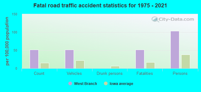
West Branch fatal accident list:
- National Bridge Inventory (NBI) Statistics
- 57Number of bridges
- 361ft / 110mTotal length
- $227,000Total costs
- 326,581Total average daily traffic
- 116,556Total average daily truck traffic
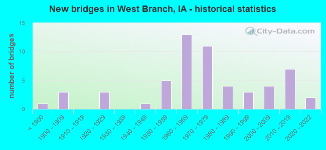
- New bridges - historical statistics
- 1Before 1900
- 31900-1909
- 31920-1929
- 11940-1949
- 51950-1959
- 131960-1969
- 111970-1979
- 41980-1989
- 31990-1999
- 42000-2009
- 72010-2019
- 22020-2022
FCC Registered Cell Phone Towers:
2 (See the full list of FCC Registered Cell Phone Towers in West Branch)FCC Registered Antenna Towers:
72 (See the full list of FCC Registered Antenna Towers)FCC Registered Broadcast Land Mobile Towers:
11 (See the full list of FCC Registered Broadcast Land Mobile Towers in West Branch, IA)FCC Registered Microwave Towers:
5- WEST BRANCH, 1825 Hayes Rd (Lat: 41.681139 Lon: -91.221000), Type: Tower, Structure height: 86.9 m, Overall height: 91.1 m, Call Sign: WQJR319,
Assigned Frequencies: 6256.54 MHz, Grant Date: 12/02/2008, Expiration Date: 12/02/2018, Cancellation Date: 03/12/2014, Certifier: Pamelia Y Hoof, Registrant: Verizon Wireless, 1120 Sanctuary Pkwy, #150 Gasa5reg, Alpharetta, GA 30009-7630, Phone: (770) 797-1070, Fax: (770) 797-1036, Email:
- WEST BRANCH, Intersection Of County Roads F44 & X16 (Lat: 41.671167 Lon: -91.424917), Type: Upole, Structure height: 17.1 m, Call Sign: WQMK774,
Assigned Frequencies: 17760.0 MHz, Grant Date: 09/07/2010, Expiration Date: 09/07/2020, Cancellation Date: 11/07/2020, Certifier: Jerry Melick, Registrant: West Liberty Telephone Company, 413 North Calhoun Street, West Liberty, IA 52776, Phone: (319) 627-0223, Fax: (319) 627-2187, Email:
- West Branch, 27 Purethane Pl (Lat: 41.659528 Lon: -91.340111), Type: Tank, Structure height: 32 m, Overall height: 35.1 m, Call Sign: WQRU474,
Assigned Frequencies: 11215.0 MHz, 11215.0 MHz, 11325.0 MHz, 11325.0 MHz, 11215.0 MHz, 11215.0 MHz, 11325.0 MHz, 11325.0 MHz, 11215.0 MHz, 11215.0 MHz... (+18 more), Grant Date: 05/17/2023, Expiration Date: 07/29/2033, Certifier: Jill Randolph, Registrant: Mcm Consulting Group, Inc, 328 Innovations Blvd. Suite 210, State College, PA 16803, Phone: (412) 995-8196, Email:
- IAWBRA01, 1547 Baker Avenue (Lat: 41.724778 Lon: -91.352833), Type: Gtower, Structure height: 422.5 m, Overall height: 443.8 m, Call Sign: WQZF909,
Assigned Frequencies: 11465.0 MHz, 11305.0 MHz, 11465.0 MHz, 11305.0 MHz, 11465.0 MHz, 11305.0 MHz, 11465.0 MHz, 11305.0 MHz, 11465.0 MHz, 11305.0 MHz... (+30 more), Grant Date: 05/05/2017, Expiration Date: 05/05/2027, Cancellation Date: 08/31/2020, Certifier: Mike Denny, Registrant: Law Office Of Suzanne S. Goodwyn, Pllc, 1234 Tottenham Court, Reston, VA 20194, Phone: (703) 444-5475, Fax: (703) 991-0629, Email:
- West Branch GF, 480 270th Street (Lat: 41.698778 Lon: -91.273778), Type: Ltower, Structure height: 83.8 m, Overall height: 85.3 m, Call Sign: WRUS763,
Assigned Frequencies: 6034.15 MHz, 6004.50 MHz, 6034.15 MHz, 6004.50 MHz, 6034.15 MHz, 6004.50 MHz, 6034.15 MHz, 6004.50 MHz, 6034.15 MHz, 6004.50 MHz, Grant Date: 09/29/2022, Expiration Date: 09/29/2032, Certifier: Warren Wethington, Registrant: Racom, 201 W. State St., Marshalltown, IA 50158, Phone: (888) 752-1016, Email:
FCC Registered Amateur Radio Licenses:
13 (See the full list of FCC Registered Amateur Radio Licenses in West Branch)FAA Registered Aircraft:
4- Aircraft: CESSNA T182T (Category: Land, Seats: 4, Weight: Up to 12,499 Pounds), Engine: LYCOMING TI0-540 SER (310 HP) (Reciprocating)
N-Number: 182TS, N182TS, N-182TS, Serial Number: T18208237, Year manufactured: 2004, Airworthiness Date: 07/21/2004, Certificate Issue Date: 01/04/2010
Registrant (Individual): Larry E Lynch, 1437 Echo Ave, West Branch, IA 52358 - Aircraft: PIPER PA-12 (Category: Land, Seats: 3, Weight: Up to 12,499 Pounds, Speed: 82 mph), Engine: LYCOMING 0-235 SERIES (115 HP) (Reciprocating)
N-Number: 3397M, N3397M, N-3397M, Serial Number: 12-2248, Year manufactured: 1947, Airworthiness Date: 09/15/1957, Certificate Issue Date: 10/15/2020
Registrant (Individual): Pamela D Bullers, 3 Greenview Dr, West Branch, IA 52358 - Aircraft: BELLANCA 8KCAB (Category: Land, Seats: 2, Weight: Up to 12,499 Pounds, Speed: 101 mph), Engine: LYCOMING IO-320 SERIES (150 HP) (Reciprocating)
N-Number: 53876, N53876, N-53876, Serial Number: 226-76, Year manufactured: 1975, Airworthiness Date: 11/06/1975, Certificate Issue Date: 01/27/2012
Registrant (Individual): Wayne H Lynch, 512 250th St, West Branch, IA 52358 - Aircraft: DIAMOND AIRCRAFT IND INC DA 40 (Category: Land, Seats: 4, Weight: Up to 12,499 Pounds), Engine: LYCOMING IO-360-M1A+ (180 HP) (Reciprocating)
N-Number: 656BB, N656BB, N-656BB, Serial Number: 40.859, Year manufactured: 2007, Airworthiness Date: 05/07/2008, Certificate Issue Date: 04/23/2015
Registrant (Individual): Barry A Anderson, 1745 Charles Ave, West Branch, IA 52358
2002 - 2017 National Fire Incident Reporting System (NFIRS) incidents
- Fire incident types reported to NFIRS in West Branch, IA
- 21553.8%Outside Fires
- 9022.5%Mobile Property/Vehicle Fires
- 8922.2%Structure Fires
- 61.5%Other
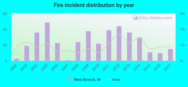 According to the data from the years 2002 - 2017 the average number of fire incidents per year is 25. The highest number of fires - 49 took place in 2005, and the least - 1 in 2007. The data has an increasing trend.
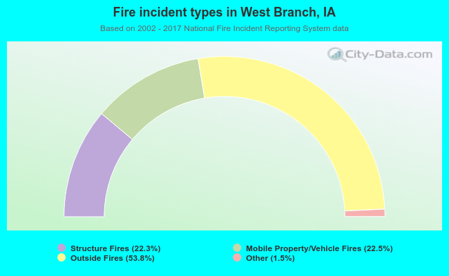 When looking into fire subcategories, the most incidents belonged to: Outside Fires (53.8%), and Mobile Property/Vehicle Fires (22.5%).
| Most common first names in West Branch, IA among deceased individuals | ||
| Name | Count | Lived (average) |
|---|---|---|
| Mary | 25 | 80.5 years |
| William | 24 | 76.2 years |
| John | 22 | 76.1 years |
| Robert | 14 | 73.3 years |
| Charles | 13 | 77.5 years |
| James | 12 | 80.4 years |
| Helen | 12 | 83.6 years |
| George | 10 | 78.3 years |
| Joseph | 10 | 71.1 years |
| Frank | 10 | 83.2 years |
| Most common last names in West Branch, IA among deceased individuals | ||
| Last name | Count | Lived (average) |
|---|---|---|
| Pedersen | 13 | 78.0 years |
| Anderson | 11 | 84.4 years |
| Hoffman | 10 | 79.6 years |
| Jensen | 10 | 86.8 years |
| Hora | 8 | 84.7 years |
| Larson | 7 | 80.3 years |
| Slach | 7 | 80.0 years |
| Rummells | 7 | 88.0 years |
| Thomas | 7 | 82.8 years |
| Williams | 7 | 77.3 years |

- 85.1%Utility gas
- 13.9%Electricity
- 0.7%Bottled, tank, or LP gas
- 0.3%No fuel used
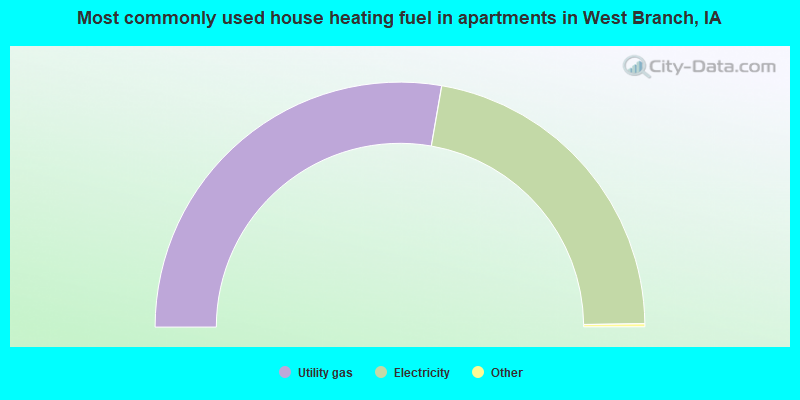
- 55.7%Utility gas
- 44.3%Electricity
West Branch compared to Iowa state average:
- Unemployed percentage significantly below state average.
- Black race population percentage significantly below state average.
- Median age below state average.
- Foreign-born population percentage significantly below state average.
- Length of stay since moving in significantly below state average.
- House age below state average.
- Number of college students below state average.
West Branch on our top lists:
- #4 on the list of "Top 100 safest cities (lowest city-data.com crime index)"
- #7 on the list of "Top 101 cities with the largest percentage of people in hospices or homes for chronically ill (population 1,000+)"
- #61 on the list of "Top 101 cities with the largest percentage of people in hospitals/wards and hospices for chronically ill (population 1,000+)"

|
|
Total of 9 patent applications in 2008-2024.