West Camas, Idaho
Submit your own pictures of this place and show them to the world
- OSM Map
- General Map
- Google Map
- MSN Map

| Males: 414 | |
| Females: 407 |
| Median resident age: | 39.5 years |
| Idaho median age: | 33.2 years |
Zip code: 83327
| West Camas: | $60,003 |
| ID: | $72,785 |
Estimated per capita income in 2022: $33,819 (it was $18,444 in 2000)
West Camas CCD income, earnings, and wages data
Estimated median house or condo value in 2022: $265,438 (it was $82,400 in 2000)
| West Camas: | $265,438 |
| ID: | $432,500 |
Mean prices in 2022: all housing units: $407,679; detached houses: $415,437; mobile homes: $312,392
Detailed information about poverty and poor residents in West Camas, ID
Compare current foreclosures near your location:
| Photo | Address | Area | Beds / Baths | Price | Details |
|---|---|---|---|---|---|

|
#1
Bayberry Cir
Columbus, OH 43207
|
1,564 sq. feet
|
1 baths 3 beds |
$127,500
|
show details |

|
#2
E 21st Ave
Columbus, OH 43211
|
1,061 sq. feet
|
1 baths 3 beds |
$187,900
|
show details |

|
#3
Stoneybrook Blvd # 21a
Hilliard, OH 43026
|
1,231 sq. feet
|
2 baths 3 beds |
show details | |

|
#4
Bernadette Rd
Columbus, OH 43204
|
1,168 sq. feet
|
1 baths 3 beds |
show details | |

|
#5
Ferris Rd
Columbus, OH 43224
|
2,218 sq. feet
|
3 baths 3 beds |
show details | |

|
#6
S Ashburton Rd
Columbus, OH 43213
|
1,220 sq. feet
|
1 baths 3 beds |
show details | |

|
#7
Sleeping Meadow Dr
New Albany, OH 43054
|
3,211 sq. feet
|
2 baths 4 beds |
show details | |

|
#8
Vineyard Haven Loop
Dublin, OH 43016
|
4,625 sq. feet
|
4 baths 4 beds |
show details | |

|
#9
Mcguffey Rd
Columbus, OH 43224
|
672 sq. feet
|
1 baths 2 beds |
show details | |

|
#10
Hiawatha Park Dr
Columbus, OH 43211
|
1,278 sq. feet
|
1 baths 4 beds |
show details |
| Photo | Address | Area | Beds / Baths | Price | Details |
|---|---|---|---|---|---|

|
#11
Brookstone Dr
Westerville, OH 43082
|
1,783 sq. feet
|
3 baths 3 beds |
show details | |

|
#12
N Roys Ave
Columbus, OH 43204
|
1,248 sq. feet
|
2 baths 3 beds |
show details | |

|
#13
Franklin Ave
Columbus, OH 43205
|
2,925 sq. feet
|
2 baths 4 beds |
show details | |

|
#14
Marshrun Dr
Grove City, OH 43123
|
2,036 sq. feet
|
2 baths 4 beds |
show details | |

|
#15
S Hague Ave
Columbus, OH 43204
|
979 sq. feet
|
1 baths 2 beds |
show details | |

|
#16
E Welch Ave
Columbus, OH 43207
|
1,864 sq. feet
|
2 baths 3 beds |
show details | |

|
#17
Kingsglen Dr
Grove City, OH 43123
|
1,635 sq. feet
|
2 baths 4 beds |
show details | |

|
#18
Gladiolus Ct
Reynoldsburg, OH 43068
|
2,208 sq. feet
|
2 baths 3 beds |
show details | |

|
#19
Blue Lake Ave
Galloway, OH 43119
|
1,540 sq. feet
|
2 baths 3 beds |
show details | |

|
#20
Derrer Rd -872
Columbus, OH 43204
|
1,667 sq. feet
|
2 baths 5 beds |
show details |
| Photo | Address | Area | Beds / Baths | Price | Details |
|---|---|---|---|---|---|

|
#21
Elaine Rd
Columbus, OH 43213
|
764 sq. feet
|
1 baths 2 beds |
show details | |

|
#22
Midland Ave
Columbus, OH 43223
|
1,518 sq. feet
|
1 baths 2 beds |
show details | |

|
#23
Mayflower Blvd
Columbus, OH 43213
|
1,591 sq. feet
|
2 baths 4 beds |
show details | |

|
#24
S Richardson Ave
Columbus, OH 43204
|
1,520 sq. feet
|
2 baths 3 beds |
show details | |

|
#25
Rosewood Ct
Powell, OH 43065
|
2,801 sq. feet
|
3 baths 4 beds |
show details | |

|
#26
N Grener Ave
Columbus, OH 43228
|
1,120 sq. feet
|
1 baths 3 beds |
show details | |

|
#27
Stone Shadow Dr
Blacklick, OH 43004
|
1,640 sq. feet
|
2 baths 3 beds |
show details | |

|
#28
Spohn Dr
Westerville, OH 43081
|
1,040 sq. feet
|
1 baths 3 beds |
show details | |

|
#29
Bretton Pl
Columbus, OH 43211
|
1,056 sq. feet
|
1 baths 3 beds |
show details | |

|
#30
High Free Pike
West Jefferson, OH 43162
|
1,216 sq. feet
|
2 baths 4 beds |
show details |
| Photo | Address | Area | Beds / Baths | Price | Details |
|---|---|---|---|---|---|

|
#31
Traci Ct
Columbus, OH 43207
|
925 sq. feet
|
3 baths 3 beds |
show details | |

|
#32
S Chillicothe St
Plain City, OH 43064
|
1,736 sq. feet
|
2 baths 4 beds |
show details | |

|
#33
Belle Oak Dr
Galloway, OH 43119
|
1,296 sq. feet
|
2 baths 3 beds |
show details | |

|
#34
Arborlee Dr
Reynoldsburg, OH 43068
|
1,263 sq. feet
|
2 baths 3 beds |
show details | |

|
#35
Mink St SW
Pataskala, OH 43062
|
1,442 sq. feet
|
1 baths 3 beds |
show details | |

|
#36
Falls Peak Ln
Delaware, OH 43015
|
1,352 sq. feet
|
2 baths 2 beds |
show details | |

|
#37
Meadowbrook Dr
Columbus, OH 43207
|
1,752 sq. feet
|
2 baths 4 beds |
show details | |

|
#38
Scottwood Rd
Columbus, OH 43227
|
1,008 sq. feet
|
1 baths 3 beds |
show details | |

|
#39
Minerva Ave
Columbus, OH 43229
|
2,008 sq. feet
|
3 baths 4 beds |
show details | |

|
#40
Omega Dr
Columbus, OH 43231
|
1,292 sq. feet
|
2 baths 3 beds |
show details |
| Photo | Address | Area | Beds / Baths | Price | Details |
|---|---|---|---|---|---|

|
#41
Greenhaven Ave
Galloway, OH 43119
|
1,986 sq. feet
|
2 baths 4 beds |
show details | |

|
#42
Dimson Dr S
Columbus, OH 43213
|
1,054 sq. feet
|
1 baths 3 beds |
show details | |

|
#43
Alder Vista Dr
Columbus, OH 43231
|
1,377 sq. feet
|
1 baths 2 beds |
show details | |

|
#44
Mayflower Cir
Grove City, OH 43123
|
2,084 sq. feet
|
2 baths 4 beds |
show details | |

|
#45
Rio Grande Ave
Groveport, OH 43125
|
1,056 sq. feet
|
1 baths 3 beds |
show details | |

|
#46
Omega Dr
Columbus, OH 43231
|
1,276 sq. feet
|
2 baths 3 beds |
show details | |

|
#47
Blaine Dr
Columbus, OH 43227
|
1,294 sq. feet
|
1 baths 3 beds |
show details | |

|
#48
Wallcrest Blvd
Columbus, OH 43231
|
2,152 sq. feet
|
2 baths 3 beds |
show details | |

|
#49
Oklahoma Ave
Columbus, OH 43230
|
1,824 sq. feet
|
1 baths 4 beds |
show details | |

|
Check over 1 million property listings on Foreclosure.com!
|
browse all offers | |||

- 67491.1%White alone
- 496.6%Hispanic
- 141.9%Two or more races
- 20.3%American Indian alone
- 10.1%Asian alone

Races in West Camas detailed stats: ancestries, foreign born residents, place of birth
 Recent articles from our blog. Our writers, many of them Ph.D. graduates or candidates, create easy-to-read articles on a wide variety of topics.

Current Local Time: MST time zone
Land area: 532.5 square miles.
Population density: 1.5 people per square mile (very low).

| West Camas CCD: | 0.7% ($563) |
| Idaho: | 1.0% ($1,007) |
Nearest city with pop. 50,000+: Boise, ID  (69.4 miles , pop. 185,787).
Nearest city with pop. 200,000+: Northwest Clackamas, OR (406.1 miles , pop. 224,220).
Nearest city with pop. 1,000,000+: Los Angeles, CA (671.4 miles , pop. 3,694,820).
Nearest cities:
), ), Latitude: 43.41 N, Longitude: 114.88 W
Area code commonly used in this area: 208


| Here: | 3.0% |
| Idaho: | 3.1% |

- Educational services (14.7%)
- Agriculture, forestry, fishing & hunting (13.3%)
- Construction (13.1%)
- Accommodation & food services (12.5%)
- Public administration (7.5%)
- Health care (5.1%)
- Food & beverage stores (4.8%)

- Construction (23.3%)
- Agriculture, forestry, fishing & hunting (18.6%)
- Educational services (10.5%)
- Accommodation & food services (9.5%)
- Public administration (4.8%)
- Building material & garden equipment & supplies dealers (2.9%)
- Truck transportation (2.9%)

- Educational services (20.0%)
- Accommodation & food services (16.4%)
- Health care (11.5%)
- Public administration (10.9%)
- Food & beverage stores (7.3%)
- Agriculture, forestry, fishing & hunting (6.7%)
- Administrative & support & waste management services (4.2%)

- Preschool, kindergarten, elementary, and middle school teachers (8.0%)
- Driver/sales workers and truck drivers (6.7%)
- Cooks and food preparation workers (5.1%)
- Carpenters (4.0%)
- Electrical equipment mechanics and other installation, maintenance, and repair workers, including supervisors (3.7%)
- Other production occupations, including supervisors (3.7%)
- Building and grounds cleaning and maintenance occupations (3.2%)

- Driver/sales workers and truck drivers (10.0%)
- Carpenters (7.1%)
- Electrical equipment mechanics and other installation, maintenance, and repair workers, including supervisors (6.7%)
- Vehicle and mobile equipment mechanics, installers, and repairers (5.7%)
- Agricultural workers, including supervisors (5.2%)
- Preschool, kindergarten, elementary, and middle school teachers (4.8%)
- Construction traders workers except carpenters, electricians, painters, plumbers, and construction laborers (4.8%)

- Preschool, kindergarten, elementary, and middle school teachers (12.1%)
- Cooks and food preparation workers (6.7%)
- Secretaries and administrative assistants (6.7%)
- Building and grounds cleaning and maintenance occupations (6.1%)
- Other office and administrative support workers, including supervisors (6.1%)
- Information and record clerks, except customer service representatives (4.8%)
- Retail sales workers, except cashiers (4.2%)
Average climate in West Camas, Idaho
Based on data reported by over 4,000 weather stations


Earthquake activity:
West Camas-area historical earthquake activity is significantly above Idaho state average. It is 2092% greater than the overall U.S. average.On 10/28/1983 at 14:06:06, a magnitude 7.3 (6.2 MB, 7.3 MS, 7.0 MW, Class: Major, Intensity: VIII - XII) earthquake occurred 71.2 miles away from the city center, causing 2 deaths (2 shaking deaths) and 3 injuries, causing $15,000,000 total damage
On 8/18/1959 at 06:37:13, a magnitude 7.7 (7.7 UK) earthquake occurred 225.2 miles away from West Camas center, causing $26,000,000 total damage
On 10/3/1915 at 06:52:48, a magnitude 7.6 (7.6 UK) earthquake occurred 241.9 miles away from West Camas center
On 3/31/2020 at 23:52:30, a magnitude 6.5 (6.5 MW, Depth: 7.5 mi, Class: Strong, Intensity: VII - IX) earthquake occurred 74.2 miles away from the city center
On 3/28/1975 at 02:31:05, a magnitude 6.2 (6.1 MB, 6.0 MS, 6.2 ML) earthquake occurred 155.8 miles away from the city center
On 12/16/1954 at 11:07:12, a magnitude 7.0 (7.0 UK) earthquake occurred 332.9 miles away from West Camas center
Magnitude types: body-wave magnitude (MB), local magnitude (ML), surface-wave magnitude (MS), moment magnitude (MW)
Natural disasters:
The number of natural disasters in Camas County (6) is a lot smaller than the US average (15).Major Disasters (Presidential) Declared: 2
Emergencies Declared: 2
Causes of natural disasters: Floods: 3, Drought: 1, Heavy Rain: 1, Hurricane: 1, Landslide: 1, Mudslide: 1, Storm: 1, Other: 1 (Note: some incidents may be assigned to more than one category).
Colleges/universities with over 2000 students nearest to West Camas:
- College of Southern Idaho (about 61 miles; Twin Falls, ID; Full-time enrollment: 5,051)
- Boise State University (about 68 miles; Boise, ID; FT enrollment: 16,774)
- College of Western Idaho (about 83 miles; Nampa, ID; FT enrollment: 6,300)
- Northwest Nazarene University (about 86 miles; Nampa, ID; FT enrollment: 2,290)
- Treasure Valley Community College (about 113 miles; Ontario, OR; FT enrollment: 2,055)
- Idaho State University (about 130 miles; Pocatello, ID; FT enrollment: 10,350)
- Brigham Young University-Idaho (about 158 miles; Rexburg, ID; FT enrollment: 30,522)
Points of interest:
Notable locations in West Camas: Indian Hole (A), River Bend Campground (B), Narrows Campground (C), Ear Creek Sheep Corral (D), Fir Grove Ranch (E), Mormon Reservoir Access Area (F), Little Smokey Patrol Cabin (G), Pioneer Campground (H), Skeleton Campground (I), Soldier Forest Camp (J), Little Smoky Campground (K), Dean Camp (L), Five Points Campground (M), Baumgartner Campground (N), Corral (O), Bighorn Campground (P), Soldier Mountain Ski Area (Q), Big Smoky Campground (R), Camas County - Fairfield Volunteer Fire District (S). Display/hide their locations on the map
Cemeteries: Hill City Cemetery (1), Corral Cemetery (2), Mountain View Cemetery (3). Display/hide their locations on the map
Lakes and reservoirs: Little Bear Lake (A), Smoky Dome Lakes (B), Ross Fork Lakes (C), Bass Lakes (D), Perkons Lake (E), Goat Lake (F), Heart Lake (G), Mormon Reservoir (H). Display/hide their locations on the map
Streams, rivers, and creeks: Dairy Creek (A), Chimney Creek (B), Mays Creek (C), McKinney Creek (D), Burnt Log Creek (E), Bremner Creek (F), Big Smoky Creek (G), Pepper Creek (H), Perkons Creek (I). Display/hide their locations on the map
Park in West Camas: Deer Park (1). Display/hide its location on the map
| This place: | 2.3 people |
| Idaho: | 2.7 people |
| This place: | 67.5% |
| Whole state: | 69.6% |
| This place: | 5.9% |
| Whole state: | 6.3% |
Likely homosexual households (counted as self-reported same-sex unmarried-partner households)
- Lesbian couples: 0.0% of all households
- Gay men: 0.3% of all households
| This place: | 9.2% |
| Whole state: | 11.8% |
| This place: | 3.4% |
| Whole state: | 4.6% |
For population 15 years and over in West Camas:

- Never married: 22.1%
- Now married: 66.3%
- Separated: 1.3%
- Widowed: 5.3%
- Divorced: 6.3%
For population 25 years and over in West Camas:
- High school or higher: 88.3%
- Bachelor's degree or higher: 18.9%
- Graduate or professional degree: 4.0%
- Unemployed: 3.1%
- Mean travel time to work (commute): 23.8 minutes


| Here: | 8.8 |
| Idaho average: | 11.1 |
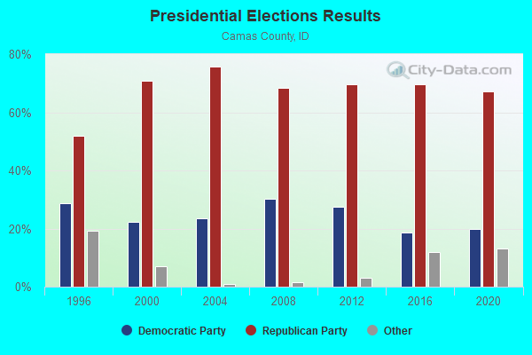
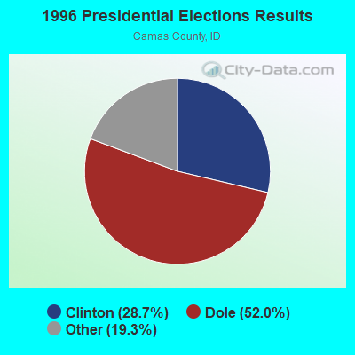
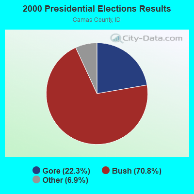


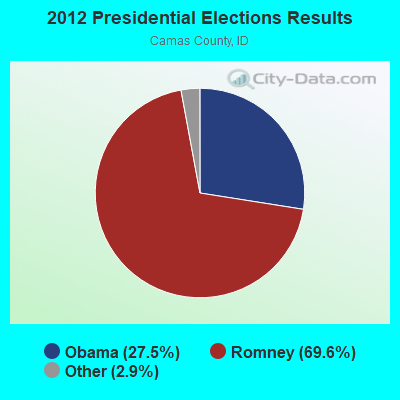

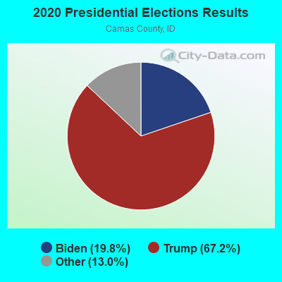
Graphs represent county-level data. Detailed 2008 Election Results
Religion statistics for West Camas, ID (based on Camas County data)
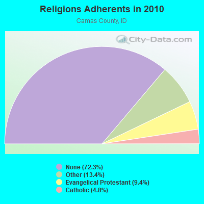
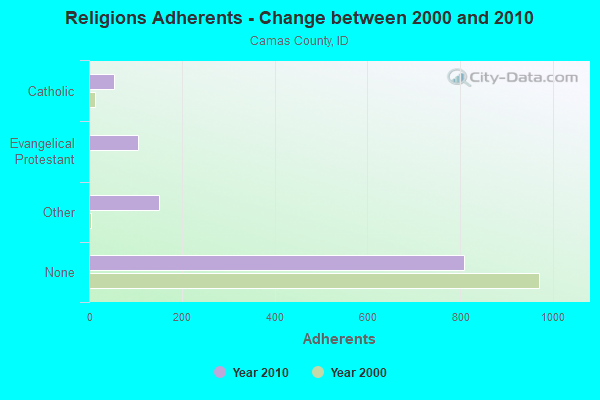
| Religion | Adherents | Congregations |
|---|---|---|
| Other | 150 | 1 |
| Evangelical Protestant | 105 | 1 |
| Catholic | 54 | 1 |
| None | 808 | - |
Food Environment Statistics:
| This county: | 9.12 / 10,000 pop. |
| Idaho: | 1.88 / 10,000 pop. |
| Here: | 27.37 / 10,000 pop. |
| Idaho: | 7.75 / 10,000 pop. |
| Camas County: | 7.6% |
| State: | 7.7% |
| Camas County: | 26.8% |
| Idaho: | 25.7% |
Strongest AM radio stations in West Camas:
- KBOI (670 AM; 50 kW; BOISE, ID; Owner: CITADEL BROADCASTING COMPANY)
- KBSU (730 AM; 15 kW; BOISE, ID; Owner: IDAHO STATE BOARD OF EDUCATION)
- KWEI (1260 AM; 50 kW; WEISER, ID; Owner: TREASURE VALLEY BROADCASTING CO.)
- KRXR (1480 AM; 5 kW; GOODING, ID; Owner: MARIA ELENA JUAREZ)
- KGEM (1140 AM; 10 kW; BOISE, ID; Owner: JOURNAL BROADCAST CORPORATION)
- KFXD (630 AM; 5 kW; BOISE, ID; Owner: CITICASTERS LICENSES, L.P.)
- KIDO (580 AM; 5 kW; NAMPA, ID; Owner: CITICASTERS LICENSES, L.P.)
- KBGN (1060 AM; daytime; 10 kW; CALDWELL, ID; Owner: NELSON M. AND KAREN E. WILSON)
- KALL (700 AM; 50 kW; NORTH SALT LAKE CITY, UT; Owner: CITICASTERS LICENSES, L.P.)
- KTFI (1270 AM; 5 kW; TWIN FALLS, ID; Owner: AGM-IDAHO BROADCASTING, LLC)
- KLIX (1310 AM; 5 kW; TWIN FALLS, ID; Owner: CITICASTERS LICENSES, L.P.)
- KIQN (1010 AM; 50 kW; TOOELE, UT)
- KZNR (690 AM; 10 kW; BLACKFOOT, ID; Owner: WESTERN COMMUNICATIONS, INC.)
Strongest FM radio stations in West Camas:
- KYZK (107.5 FM; SUN VALLEY, ID; Owner: ALPINE BROADCASTING, LTD.)
- KECH-FM (95.3 FM; SUN VALLEY, ID; Owner: ALPINE BROADCASTING LTD PARTNERSHIP)
- KIKX (104.7 FM; KETCHUM, ID; Owner: AGM-IDAHO BROADCASTING, LLC)
- K216CY (91.1 FM; SUN VALLEY, ID; Owner: BOISE ST. UNIV., ID ST BD OF EDUCA.)
- KWRV (91.9 FM; SUN VALLEY, ID; Owner: MINNESOTA PUBLIC RADIO)
- KSKI-FM (103.7 FM; SUN VALLEY, ID; Owner: ALPINE BROADCASTING LTD PARTNERSHIP)
- KTPZ (99.1 FM; MOUNTAIN HOME, ID; Owner: AGM-IDAHO BROADCASTING, LLC)
- KISY (100.7 FM; GOODING, ID; Owner: AGM-IDAHO BROADCASTING, LLC)
- KIZN (92.3 FM; BOISE, ID; Owner: CITADEL BROADCASTING COMPANY)
- KKGL (96.9 FM; NAMPA, ID; Owner: CITADEL BROADCASTING COMPANY)
- KQFC (97.9 FM; BOISE, ID; Owner: CITADEL BROADCASTING COMPANY)
- KZMG (93.1 FM; NEW PLYMOUTH, ID; Owner: CITADEL BROADCASTING COMPANY)
- KBSX (91.5 FM; BOISE, ID; Owner: IDAHO STATE BOARD OF EDUCATION)
- KBSU-FM (90.3 FM; BOISE, ID; Owner: IDAHO STATE BOARD OF EDUCATION)
- KCIX (105.9 FM; GARDEN CITY, ID; Owner: CITICASTERS LICENSES, L.P.)
- KRVB (94.9 FM; NAMPA, ID; Owner: JOURNAL BROADCAST CORPORATION)
- KXLT-FM (107.9 FM; EAGLE, ID; Owner: CITICASTERS LICENSES, L.P.)
- KJOT (105.1 FM; BOISE, ID; Owner: JOURNAL BROADCAST CORPORATION)
- KTHI (107.1 FM; CALDWELL, ID; Owner: JOURNAL BROADCAST CORPORATION)
- KBXL (94.1 FM; CALDWELL, ID; Owner: KSPD, INC.)

- 35.7%Wood
- 27.3%Electricity
- 21.1%Bottled, tank, or LP gas
- 11.5%Fuel oil, kerosene, etc.
- 3.5%Other fuel
- 0.9%Coal or coke

- 39.7%Electricity
- 25.0%Wood
- 23.5%Bottled, tank, or LP gas
- 4.4%Fuel oil, kerosene, etc.
- 4.4%Solar energy
- 2.9%Utility gas
West Camas compared to Idaho state average:
- Median house value below state average.
- Unemployed percentage significantly below state average.
- Black race population percentage above state average.
- Hispanic race population percentage below state average.
- Median age below state average.
- Foreign-born population percentage significantly below state average.
- Length of stay since moving in significantly above state average.
- Number of rooms per house significantly below state average.
- House age significantly below state average.
West Camas on our top lists:
- #90 on the list of "Top 101 cities with the most residents born in Chile (population 500+)"
- #61 on the list of "Top 101 counties with the lowest total withdrawal of fresh water for public supply"
- #86 on the list of "Top 101 counties with the highest percentage of residents relocating to other counties in 2011"