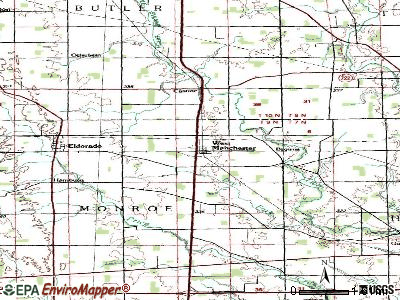
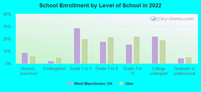
West Manchester, Ohio

West Manchester: THE OHIO RIVER.

West Manchester: MANCHESTERS OHIO HISTORICAL MARKER
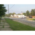
West Manchester: MANCHESTERS DOWNTOWN -STATE ROUTE 52.
- add
your


Submit your own pictures of this village and show them to the world
- OSM Map
- General Map
- Google Map
- MSN Map
Population change since 2000: -4.8%
 |
| Males: 212 | |
| Females: 200 |
| Median resident age: | 42.6 years |
| Ohio median age: | 39.9 years |
Zip codes: 45382.
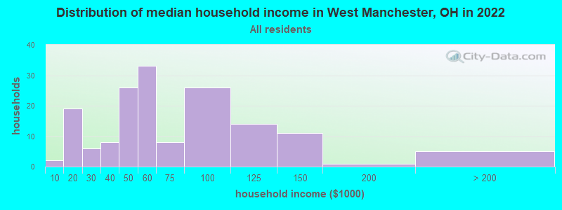
| West Manchester: | $54,693 |
| OH: | $65,720 |
Estimated per capita income in 2022: $55,842 (it was $16,968 in 2000)
West Manchester village income, earnings, and wages data
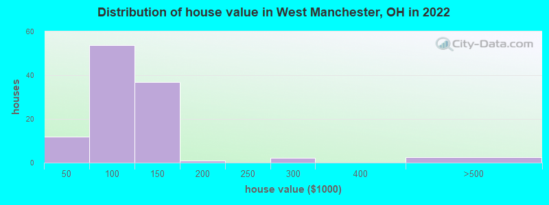
Estimated median house or condo value in 2022: $101,438 (it was $68,200 in 2000)
| West Manchester: | $101,438 |
| OH: | $204,100 |
Mean prices in 2022: all housing units: $105,170; detached houses: $105,289
Median gross rent in 2022: $1,073.
West Manchester, OH residents, houses, and apartments details
Detailed information about poverty and poor residents in West Manchester, OH
Compare current foreclosures near West Manchester, OH:
| Photo | Address | Area | Beds / Baths | Price | Details |
|---|---|---|---|---|---|

|
#1
Stephens Rd
West Manchester, OH 45382
|
1,605 sq. feet
|
1 baths 2 beds |
show details | |

|
#2
Ruth Ave
Gettysburg, OH 45328
|
1,400 sq. feet
|
2 baths 3 beds |
$54,900
|
show details |

|
#3
S A St
Richmond, IN 47374
|
976 sq. feet
|
1 baths 3 beds |
$119,900
|
show details |

|
#4
Us Route 127
West Manchester, OH 45382
|
- sq. feet
|
- baths - beds |
show details | |

|
#5
S 10th St
Richmond, IN 47374
|
1,154 sq. feet
|
1 baths 3 beds |
$24,900
|
show details |

|
#6
Pearl St
Richmond, IN 47374
|
1,352 sq. feet
|
1 baths 2 beds |
show details | |

|
#7
N 20th St
Richmond, IN 47374
|
1,372 sq. feet
|
1 baths 3 beds |
show details | |

|
#8
Barnside Dr
Englewood, OH 45322
|
2,538 sq. feet
|
2 baths 4 beds |
show details | |

|
#9
Rolling Dr
Richmond, IN 47374
|
1,232 sq. feet
|
1 baths 3 beds |
show details | |

|
#10
Western Ave
Lewisburg, OH 45338
|
- sq. feet
|
1 baths 3 beds |
show details |
| Photo | Address | Area | Beds / Baths | Price | Details |
|---|---|---|---|---|---|

|
#11
Quinn Rd
West Alexandria, OH 45381
|
1,512 sq. feet
|
1 baths 3 beds |
show details | |

|
#12
520 Cherry St
Eaton, OH 45320
|
903 sq. feet
|
1 baths 1 beds |
show details | |

|
#13
Stayton Ave
Eldorado, OH 45321
|
- sq. feet
|
1 baths 3 beds |
show details | |

|
#14
S Spring St
New Paris, OH 45347
|
1,807 sq. feet
|
1 baths 3 beds |
show details | |

|
#15
Kensington Dr
Richmond, IN 47374
|
2,512 sq. feet
|
2 baths 3 beds |
show details | |

|
#16
Crawford Rd
New Lebanon, OH 45345
|
1,248 sq. feet
|
1 baths 3 beds |
show details | |

|
#17
N 17th St
Richmond, IN 47374
|
1,168 sq. feet
|
1 baths 3 beds |
show details | |

|
#18
Skodborg Dr
Eaton, OH 45320
|
1,890 sq. feet
|
2 baths 3 beds |
show details | |

|
#19
W Martindale Rd
Englewood, OH 45322
|
1,122 sq. feet
|
1 baths 3 beds |
show details | |

|
#20
N 18th St
Richmond, IN 47374
|
1,184 sq. feet
|
1 baths 2 beds |
show details |
| Photo | Address | Area | Beds / Baths | Price | Details |
|---|---|---|---|---|---|

|
#21
Franklin Ave
Englewood, OH 45322
|
1,116 sq. feet
|
2 baths 3 beds |
show details | |

|
#22
Pleasant Plain Rd
Clayton, OH 45315
|
3,028 sq. feet
|
2 baths 1 beds |
show details | |

|
#23
E 5th St
Greenville, OH 45331
|
912 sq. feet
|
1 baths 3 beds |
show details | |

|
#24
Kimmel Rd
Clayton, OH 45315
|
1,729 sq. feet
|
2 baths 3 beds |
show details | |

|
#25
Flatley Rd
Richmond, IN 47374
|
1,200 sq. feet
|
1 baths 2 beds |
show details | |

|
#26
Martin St
Greenville, OH 45331
|
1,985 sq. feet
|
1 baths 3 beds |
show details | |

|
#27
W 4th St
Greenville, OH 45331
|
4,469 sq. feet
|
3 baths 4 beds |
show details | |

|
#28
Southeast Pkwy
Richmond, IN 47374
|
2,238 sq. feet
|
2 baths 4 beds |
show details | |

|
#29
Markwith Ave
Greenville, OH 45331
|
1,642 sq. feet
|
2 baths 4 beds |
show details | |

|
#30
Sweitzer St
Greenville, OH 45331
|
1,579 sq. feet
|
1 baths 3 beds |
show details |
| Photo | Address | Area | Beds / Baths | Price | Details |
|---|---|---|---|---|---|

|
#31
Sweitzer St
Greenville, OH 45331
|
1,455 sq. feet
|
1 baths 4 beds |
show details | |

|
#32
Union Ridge Dr
Englewood, OH 45322
|
1,971 sq. feet
|
2 baths 3 beds |
show details | |

|
#33
Little Richmond Rd
Brookville, OH 45309
|
2,220 sq. feet
|
2 baths 3 beds |
show details | |

|
#34
Longman Rd
Eaton, OH 45320
|
1,325 sq. feet
|
1 baths 3 beds |
show details | |

|
#35
Scott Dr
Englewood, OH 45322
|
825 sq. feet
|
1 baths 1 beds |
show details | |

|
#36
Mccraw Dr
Englewood, OH 45322
|
1,213 sq. feet
|
1 baths 3 beds |
show details | |

|
#37
Twin Lakes Cir
Clayton, OH 45315
|
1,662 sq. feet
|
3 baths 3 beds |
show details | |

|
#38
Larrel Ln
West Milton, OH 45383
|
1,593 sq. feet
|
2 baths 3 beds |
show details | |

|
#39
West Dr
Richmond, IN 47374
|
2,444 sq. feet
|
2 baths 4 beds |
show details | |

|
#40
S 20th St
Richmond, IN 47374
|
1,432 sq. feet
|
1 baths 3 beds |
show details |
| Photo | Address | Area | Beds / Baths | Price | Details |
|---|---|---|---|---|---|

|
#41
W Martindale Rd
Englewood, OH 45322
|
1,500 sq. feet
|
1 baths 3 beds |
show details | |

|
#42
Kinsey St
Richmond, IN 47374
|
2,088 sq. feet
|
2 baths 4 beds |
show details | |

|
#43
SW 1st St
Richmond, IN 47374
|
2,416 sq. feet
|
1 baths 2 beds |
show details | |

|
#44
W Martindale Rd
Englewood, OH 45322
|
1,774 sq. feet
|
1 baths 3 beds |
show details | |

|
#45
Little Richmond Rd
Brookville, OH 45309
|
1,475 sq. feet
|
1 baths 3 beds |
show details | |

|
#46
Lofton Dr
Clayton, OH 45315
|
2,315 sq. feet
|
3 baths 3 beds |
show details | |

|
#47
N State Route 49
Greenville, OH 45331
|
1,422 sq. feet
|
1 baths 3 beds |
show details | |

|
#48
Virginia Springs Ct
Clayton, OH 45315
|
2,747 sq. feet
|
2 baths 3 beds |
show details | |

|
#49
Norseman Dr
Eaton, OH 45320
|
1,680 sq. feet
|
1 baths 3 beds |
show details | |

|
Check over 1 million property listings on Foreclosure.com!
|
browse all offers | |||


- 33093.2%White alone
- 205.6%Two or more races
- 30.8%Hispanic
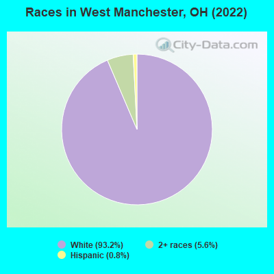
Races in West Manchester detailed stats: ancestries, foreign born residents, place of birth
According to our research of Ohio and other state lists, there were 2 registered sex offenders living in West Manchester, Ohio as of April 25, 2024.
The ratio of all residents to sex offenders in West Manchester is 265 to 1.
 Recent articles from our blog. Our writers, many of them Ph.D. graduates or candidates, create easy-to-read articles on a wide variety of topics.


Latest news from West Manchester, OH collected exclusively by city-data.com from local newspapers, TV, and radio stations
Ancestries: Irish (29.4%), German (27.6%), American (15.3%), English (4.9%), Lithuanian (1.2%), Scotch-Irish (1.2%).
Current Local Time: EST time zone
Elevation: 1093 feet
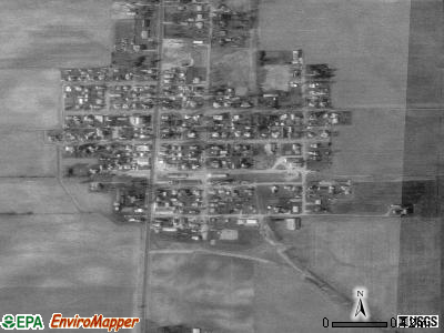
Land area: 0.23 square miles.
Population density: 1,762 people per square mile (low).
Median real estate property taxes paid for housing units with mortgages in 2022: $1,062 (1.0%)
Median real estate property taxes paid for housing units with no mortgage in 2022: $1,000 (1.2%)
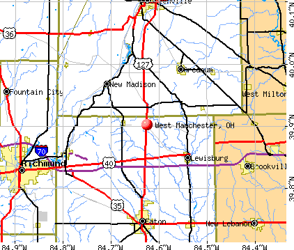
Nearest city with pop. 50,000+: Dayton, OH  (24.7 miles , pop. 166,179).
Nearest city with pop. 200,000+: Cincinnati, OH (53.4 miles , pop. 331,285).
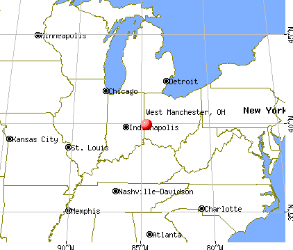
Nearest city with pop. 1,000,000+: Chicago, IL (208.5 miles , pop. 2,896,016).
Nearest cities:
), ), ), Latitude: 39.90 N, Longitude: 84.62 W
Area code: 937
| Here: | 2.7% |
| Ohio: | 3.1% |
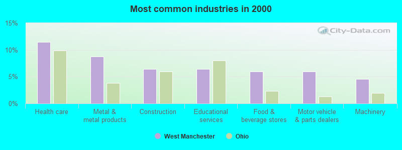
- Health care (11.5%)
- Metal & metal products (8.7%)
- Construction (6.4%)
- Educational services (6.4%)
- Food & beverage stores (6.0%)
- Motor vehicle & parts dealers (6.0%)
- Machinery (4.6%)
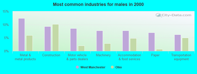
- Metal & metal products (12.4%)
- Construction (9.3%)
- Motor vehicle & parts dealers (8.5%)
- Machinery (7.8%)
- Accommodation & food services (7.8%)
- Paper (7.0%)
- Transportation equipment (6.2%)
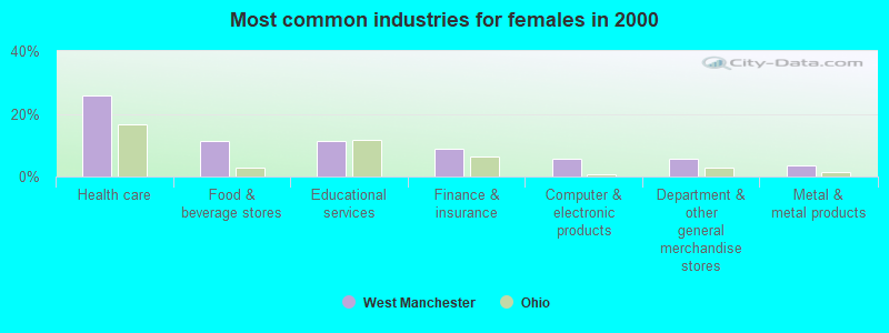
- Health care (25.8%)
- Food & beverage stores (11.2%)
- Educational services (11.2%)
- Finance & insurance (9.0%)
- Computer & electronic products (5.6%)
- Department & other general merchandise stores (5.6%)
- Metal & metal products (3.4%)
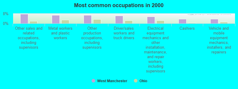
- Other sales and related occupations, including supervisors (7.8%)
- Metal workers and plastic workers (6.9%)
- Other production occupations, including supervisors (6.9%)
- Driver/sales workers and truck drivers (6.4%)
- Electrical equipment mechanics and other installation, maintenance, and repair workers, including supervisors (5.5%)
- Cashiers (3.7%)
- Vehicle and mobile equipment mechanics, installers, and repairers (3.7%)
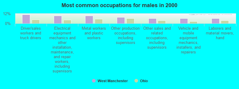
- Driver/sales workers and truck drivers (10.9%)
- Electrical equipment mechanics and other installation, maintenance, and repair workers, including supervisors (9.3%)
- Metal workers and plastic workers (9.3%)
- Other production occupations, including supervisors (7.8%)
- Other sales and related occupations, including supervisors (6.2%)
- Vehicle and mobile equipment mechanics, installers, and repairers (6.2%)
- Laborers and material movers, hand (6.2%)

- Other sales and related occupations, including supervisors (10.1%)
- Registered nurses (6.7%)
- Other office and administrative support workers, including supervisors (6.7%)
- Assemblers and fabricators (6.7%)
- Nursing, psychiatric, and home health aides (5.6%)
- Health technologists and technicians (5.6%)
- Other teachers, instructors, education, training, and library occupations (5.6%)
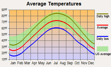
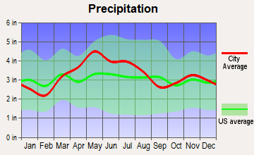
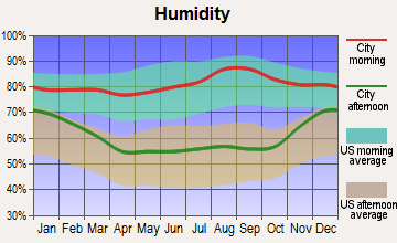
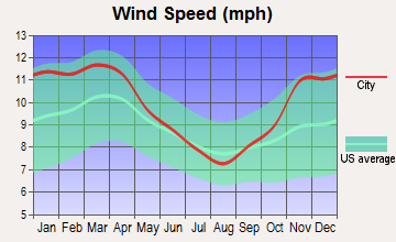
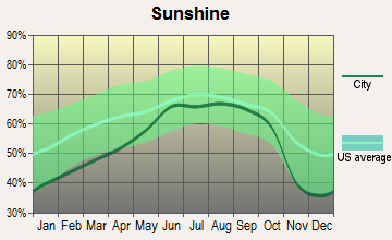
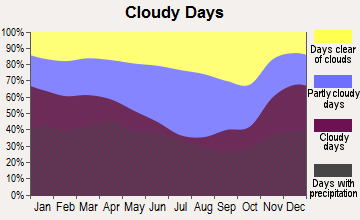
Average climate in West Manchester, Ohio
Based on data reported by over 4,000 weather stations
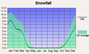
(lower is better)
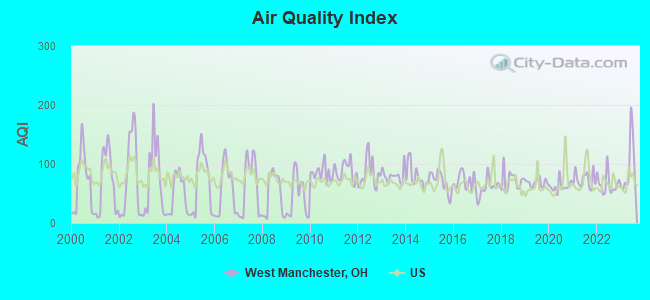
Air Quality Index (AQI) level in 2023 was 94.5. This is worse than average.
| City: | 94.5 |
| U.S.: | 72.6 |
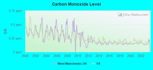
Carbon Monoxide (CO) [ppm] level in 2023 was 0.169. This is significantly better than average. Closest monitor was 6.9 miles away from the city center.
| City: | 0.169 |
| U.S.: | 0.251 |
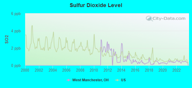
Sulfur Dioxide (SO2) [ppb] level in 2023 was 0.405. This is significantly better than average. Closest monitor was 6.9 miles away from the city center.
| City: | 0.405 |
| U.S.: | 1.515 |
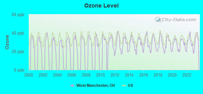
Ozone [ppb] level in 2023 was 32.6. This is about average. Closest monitor was 6.9 miles away from the city center.
| City: | 32.6 |
| U.S.: | 33.3 |
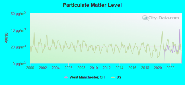
Particulate Matter (PM10) [µg/m3] level in 2023 was 19.2. This is about average. Closest monitor was 6.9 miles away from the city center.
| City: | 19.2 |
| U.S.: | 19.2 |
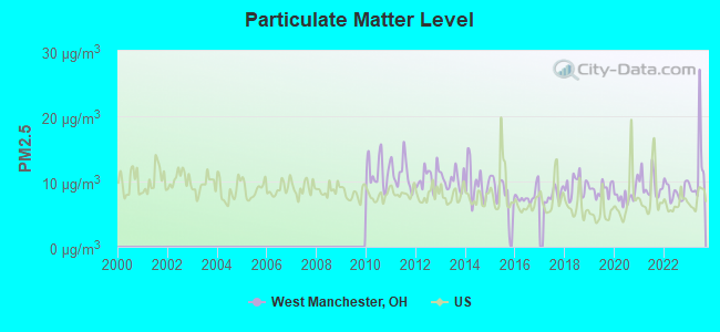
Particulate Matter (PM2.5) [µg/m3] level in 2023 was 11.7. This is significantly worse than average. Closest monitor was 6.9 miles away from the city center.
| City: | 11.7 |
| U.S.: | 8.1 |
Tornado activity:
West Manchester-area historical tornado activity is above Ohio state average. It is 82% greater than the overall U.S. average.
On 4/25/1961, a category F4 (max. wind speeds 207-260 mph) tornado 10.5 miles away from the West Manchester village center injured 7 people and caused between $500,000 and $5,000,000 in damages.
On 4/3/1974, a category F5 (max. wind speeds 261-318 mph) tornado 35.9 miles away from the village center killed 36 people and injured 1150 people and caused between $50,000,000 and $500,000,000 in damages.
Earthquake activity:
West Manchester-area historical earthquake activity is significantly above Ohio state average. It is 33% greater than the overall U.S. average.On 7/27/1980 at 18:52:21, a magnitude 5.2 (5.1 MB, 4.7 MS, 5.0 UK, 5.2 UK, Class: Moderate, Intensity: VI - VII) earthquake occurred 123.0 miles away from West Manchester center
On 4/18/2008 at 09:36:59, a magnitude 5.4 (5.1 MB, 4.8 MS, 5.4 MW, 5.2 MW) earthquake occurred 201.6 miles away from West Manchester center
On 7/12/1986 at 08:19:37, a magnitude 4.5 (4.5 MB, Class: Light, Intensity: IV - V) earthquake occurred 45.9 miles away from West Manchester center
On 4/18/2008 at 09:36:59, a magnitude 5.2 (5.2 MW, Depth: 8.9 mi) earthquake occurred 201.6 miles away from the city center
On 6/10/1987 at 23:48:54, a magnitude 5.1 (4.9 MB, 4.4 MS, 4.6 MS, 5.1 LG) earthquake occurred 189.7 miles away from West Manchester center
On 9/7/1988 at 02:28:09, a magnitude 4.6 (4.5 MB, 4.6 LG) earthquake occurred 128.1 miles away from West Manchester center
Magnitude types: regional Lg-wave magnitude (LG), body-wave magnitude (MB), surface-wave magnitude (MS), moment magnitude (MW)
Natural disasters:
The number of natural disasters in Preble County (7) is smaller than the US average (15).Major Disasters (Presidential) Declared: 2
Emergencies Declared: 4
Causes of natural disasters: Snowstorms: 2, Storms: 2, Blizzard: 1, Flood: 1, Hurricane: 1, Snow: 1, Tropical Depression: 1, Wind: 1, Other: 1 (Note: some incidents may be assigned to more than one category).
Hospitals and medical centers near West Manchester:
- PREBLE HOME HEALTH SERVICES (Home Health Center, about 10 miles away; EATON, OH)
- EATON DIALYSIS CENTER (Dialysis Facility, about 10 miles away; EATON, OH)
- GREENBRIAR NURSING CENTER THE (Nursing Home, about 10 miles away; EATON, OH)
- WESTVIEW ACRES CARE CENTER (Nursing Home, about 10 miles away; EATON, OH)
- VANCREST HEALTH CARE CENTER OF EATON (Nursing Home, about 11 miles away; EATON, OH)
- GOVERNOR HARRIS HOMESTEAD (Nursing Home, about 11 miles away; EATON, OH)
- OAKLAWN MANOR (Nursing Home, about 11 miles away; EATON, OH)
Colleges/universities with over 2000 students nearest to West Manchester:
- Indiana University-East (about 15 miles; Richmond, IN; Full-time enrollment: 2,867)
- Sinclair Community College (about 25 miles; Dayton, OH; FT enrollment: 13,779)
- University of Dayton (about 27 miles; Dayton, OH; FT enrollment: 10,392)
- Miami University-Oxford (about 28 miles; Oxford, OH; FT enrollment: 17,670)
- Edison State Community College (about 29 miles; Piqua, OH; FT enrollment: 2,049)
- Wright State University-Main Campus (about 31 miles; Dayton, OH; FT enrollment: 14,482)
- Fortis College-Centerville (about 32 miles; Centerville, OH; FT enrollment: 4,527)
Points of interest:
Notable location: West Manchester Fire Department (A). Display/hide its location on the map
Church in West Manchester: West Manchester United Methodist Church (A). Display/hide its location on the map
Drinking water stations with addresses in West Manchester and their reported violations in the past:
WARES CHAPEL UNITED METHODIST CHURCH PWS (Population served: 110, Groundwater):Past health violations:Past monitoring violations:
- MCL, Monthly (TCR) - In JUN-2011, Contaminant: Coliform. Follow-up actions: St Violation/Reminder Notice (JUN-14-2011), St Public Notif requested (JUN-14-2011), St Public Notif received (JUL-08-2011), St Compliance achieved (FEB-09-2012)
- MCL, Monthly (TCR) - Between APR-2011 and JUN-2011, Contaminant: Coliform. Follow-up actions: St Violation/Reminder Notice (MAY-26-2011), St Public Notif requested (MAY-26-2011), St Public Notif received (JUN-10-2011), St Compliance achieved (FEB-09-2012)
- One minor monitoring violation
| This village: | 2.8 people |
| Ohio: | 2.4 people |
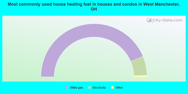
| This village: | 73.7% |
| Whole state: | 65.0% |
| This village: | 10.8% |
| Whole state: | 6.8% |
Likely homosexual households (counted as self-reported same-sex unmarried-partner households)
- Lesbian couples: 0.0% of all households
- Gay men: 0.6% of all households
Banks with branches in West Manchester (2011 data):
- United Midwest Savings Bank: The First State Bk. Of W. Manchester at 101 North Main Street, branch established on 1897/01/01. Info updated 2011/07/21: Bank assets: $213.2 mil, Deposits: $194.3 mil, headquarters in De Graff, OH, negative income in the last year, Commercial Lending Specialization, 5 total offices
For population 15 years and over in West Manchester:
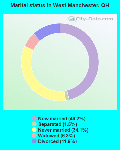
- Never married: 34.1%
- Now married: 46.2%
- Separated: 1.5%
- Widowed: 6.3%
- Divorced: 11.9%
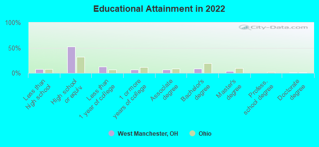
For population 25 years and over in West Manchester:
- High school or higher: 91.5%
- Bachelor's degree or higher: 13.0%
- Graduate or professional degree: 4.9%
- Unemployed: 3.5%
- Mean travel time to work (commute): 28.4 minutes
| Here: | 7.9 |
| Ohio average: | 11.0 |
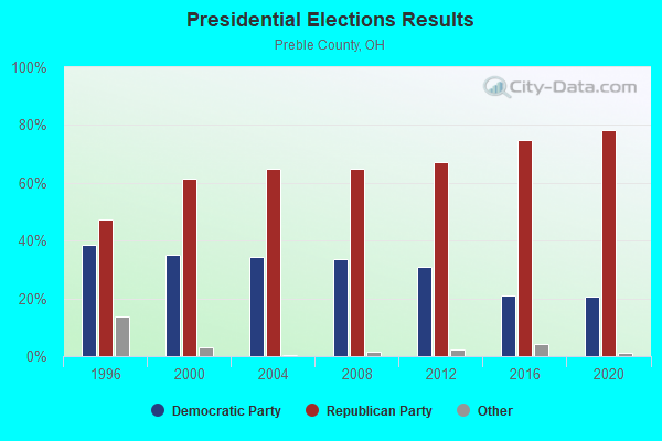
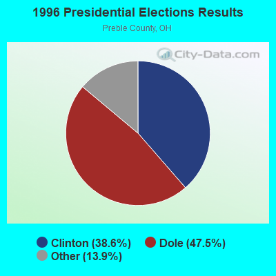
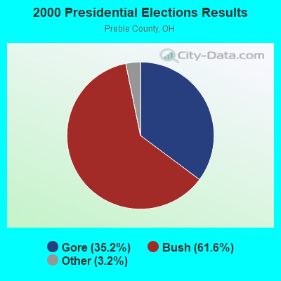
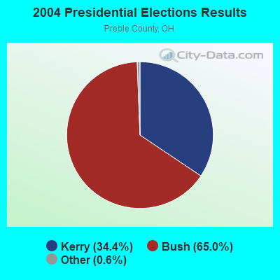
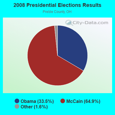
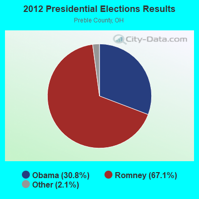

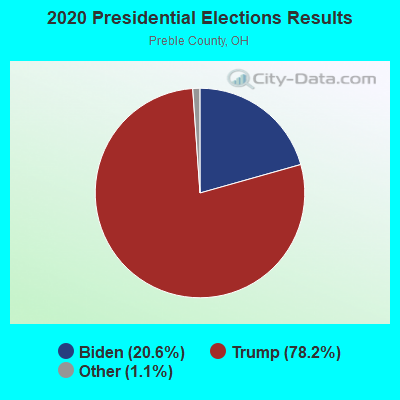
Graphs represent county-level data. Detailed 2008 Election Results
Political contributions by individuals in West Manchester, OH
Religion statistics for West Manchester, OH (based on Preble County data)
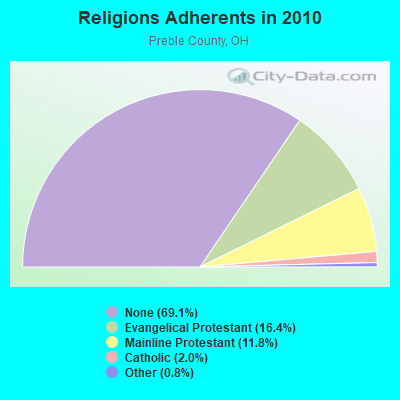
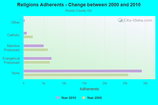
| Religion | Adherents | Congregations |
|---|---|---|
| Evangelical Protestant | 6,940 | 44 |
| Mainline Protestant | 4,974 | 29 |
| Catholic | 845 | 3 |
| Other | 319 | 3 |
| None | 29,192 | - |
Food Environment Statistics:
| Preble County: | 0.72 / 10,000 pop. |
| State: | 1.89 / 10,000 pop. |
| This county: | 0.24 / 10,000 pop. |
| Ohio: | 0.13 / 10,000 pop. |
| This county: | 0.72 / 10,000 pop. |
| Ohio: | 1.25 / 10,000 pop. |
| This county: | 2.16 / 10,000 pop. |
| Ohio: | 2.93 / 10,000 pop. |
| This county: | 6.49 / 10,000 pop. |
| Ohio: | 6.25 / 10,000 pop. |
| Preble County: | 10.4% |
| Ohio: | 10.3% |
| This county: | 28.5% |
| State: | 29.1% |
| Preble County: | 12.2% |
| Ohio: | 11.9% |
Health and Nutrition:
| West Manchester: | 61.8% |
| Ohio: | 50.4% |
| West Manchester: | 68.1% |
| Ohio: | 47.8% |
| West Manchester: | 26.6 |
| Ohio: | 28.7 |
| West Manchester: | 19.6% |
| State: | 20.6% |
| West Manchester: | 8.9% |
| Ohio: | 10.4% |
| West Manchester: | 7.3 |
| State: | 6.8 |
| West Manchester: | 31.8% |
| State: | 34.3% |
| West Manchester: | 69.1% |
| Ohio: | 57.0% |
| This city: | 85.9% |
| Ohio: | 79.1% |
More about Health and Nutrition of West Manchester, OH Residents
| Local government employment and payroll (March 2022) | |||||
| Function | Full-time employees | Monthly full-time payroll | Average yearly full-time wage | Part-time employees | Monthly part-time payroll |
|---|---|---|---|---|---|
| Financial Administration | 2 | $14,191 | $85,146 | 1 | $497 |
| Totals for Government | 2 | $14,191 | $85,146 | 1 | $497 |
West Manchester government finances - Expenditure in 2017 (per resident):
- Current Operations - Sewerage: $139,000 ($337.38)
Water Utilities: $75,000 ($182.04)
Local Fire Protection: $57,000 ($138.35)
Solid Waste Management: $45,000 ($109.22)
Regular Highways: $28,000 ($67.96)
Financial Administration: $18,000 ($43.69)
General - Other: $10,000 ($24.27)
Judicial and Legal Services: $1,000 ($2.43)
Central Staff Services: $1,000 ($2.43)
- General - Interest on Debt: $64,000 ($155.34)
- Total Salaries and Wages: $83,000 ($201.46)
West Manchester government finances - Revenue in 2017 (per resident):
- Charges - Sewerage: $139,000 ($337.38)
Solid Waste Management: $45,000 ($109.22)
- Local Intergovernmental - Highways: $4,000 ($9.71)
- Miscellaneous - Special Assessments: $7,000 ($16.99)
Rents: $1,000 ($2.43)
- Revenue - Water Utilities: $75,000 ($182.04)
- State Intergovernmental - Highways: $24,000 ($58.25)
- Tax - Property: $10,000 ($24.27)
West Manchester government finances - Debt in 2017 (per resident):
- Long Term Debt - Outstanding Unspecified Public Purpose: $1,588,000 ($3854.37)
Beginning Outstanding - Unspecified Public Purpose: $1,588,000 ($3854.37)
West Manchester government finances - Cash and Securities in 2017 (per resident):
- Other Funds - Cash and Securities: $369,000 ($895.63)
Strongest AM radio stations in West Manchester:
- WLW (700 AM; 50 kW; CINCINNATI, OH; Owner: JACOR BROADCASTING CORPORATION)
- WSAI (1530 AM; 50 kW; CINCINNATI, OH; Owner: JACOR BROADCASTING CORPORATION)
- WTVN (610 AM; 50 kW; COLUMBUS, OH; Owner: CITICASTERS LICENSES, L.P.)
- WONE (980 AM; 5 kW; DAYTON, OH; Owner: CITICASTERS LICENSES, L.P.)
- WOWO (1190 AM; 50 kW; FORT WAYNE, IN; Owner: PATHFINDER COMMUNICATIONS CORPORATION)
- WIBC (1070 AM; 50 kW; INDIANAPOLIS, IN; Owner: EMMIS RADIO LICENSE CORPORATION)
- WING (1410 AM; 5 kW; DAYTON, OH)
- WHIO (1290 AM; 5 kW; DAYTON, OH; Owner: CXR HOLDINGS, INC.)
- WHAS (840 AM; 50 kW; LOUISVILLE, KY; Owner: CLEAR CHANNEL BROADCASTING LICENSES, INC.)
- WRFD (880 AM; daytime; 23 kW; COLUMBUS-WORTHINGTON, OH; Owner: SALEM MEDIA OF OHIO, INC.)
- WKBV (1490 AM; 1 kW; RICHMOND, IN; Owner: RODGERS BROADCASTING CORP.)
- WKRC (550 AM; 5 kW; CINCINNATI, OH; Owner: JACOR BROADCASTING CORPORATION)
- WCNW (1560 AM; daytime; 5 kW; FAIRFIELD, OH)
Strongest FM radio stations in West Manchester:
- WGTZ (92.9 FM; EATON, OH; Owner: BLUE CHIP BROADCASTING LICENSES, LTD)
- WHKO (99.1 FM; DAYTON, OH; Owner: CXR HOLDINGS, INC.)
- WDKF (94.5 FM; ENGLEWOOD, OH; Owner: CITICASTERS LICENSES, L.P.)
- WFMG (101.3 FM; RICHMOND, IN; Owner: RODGERS BROADCASTING CORP.)
- WQLK (96.1 FM; RICHMOND, IN; Owner: BREWER BROADCASTING CORP.)
- WDJO (106.5 FM; GREENVILLE, OH; Owner: CITICASTERS LICENSES, L.P.)
- WVXR (89.3 FM; RICHMOND, IN; Owner: XAVIER UNIVERSITY)
- WDPG (89.9 FM; GREENVILLE, OH; Owner: DAYTON PUBLIC RADIO, INC.)
- WRNB (92.1 FM; WEST CARROLLTON, OH; Owner: RADIO ONE OF DAYTON LICENSES, LLC)
- WLQT (99.9 FM; KETTERING, OH; Owner: CITICASTERS LICENSES, L.P.)
- WMMX (107.7 FM; DAYTON, OH; Owner: CITICASTERS LICENSES, L.P.)
- WTUE (104.7 FM; DAYTON, OH; Owner: CITICASTERS LICENSES, L.P.)
- W213AO (90.5 FM; NEW PARIS, OH; Owner: THE CEDARVILLE UNIVERSITY)
- WMOJ (94.9 FM; FAIRFIELD, OH; Owner: WVAE LICO, INC.)
- WFCJ (93.7 FM; MIAMISBURG, OH; Owner: MIAMI VALLEY CHRISTIAN BROADCASTING ASSOCIATION)
- WMUB (88.5 FM; OXFORD, OH; Owner: THE PRES.& TRUSTEES OF MIAMI UNIV.)
- WXEG (103.9 FM; BEAVERCREEK, OH; Owner: CITICASTERS LICENSES, L.P.)
- WPFB-FM (105.9 FM; MIDDLETOWN, OH; Owner: RADIO STATIONS WPAY/WPFB, INC.)
- WDPT (95.7 FM; PIQUA, OH; Owner: CXR HOLDINGS, INC.)
- WTGR (97.5 FM; UNION CITY, OH; Owner: POSITIVE RADIO GROUP, INC. OF OHIO)
TV broadcast stations around West Manchester:
- WHIO-TV (Channel 7; DAYTON, OH; Owner: WHIO-TV HOLDINGS, INC.)
- WDTN (Channel 2; DAYTON, OH; Owner: WDTN BROADCASTING, LLC)
- WKEF (Channel 22; DAYTON, OH; Owner: WKEF LICENSEE L.P.)
- WRGT-TV (Channel 45; DAYTON, OH; Owner: WRGT LICENSEE, LLC)
- WPTD (Channel 16; DAYTON, OH; Owner: GREATER DAYTON PUBLIC TV, INC.)
- WPTO (Channel 14; OXFORD, OH; Owner: GREATER DAYTON PUBLIC TELEVISION, INC.)
- W61DE (Channel 61; CINCINNATI, OH; Owner: TRINITY BROADCASTING NETWORK)
- WKOI (Channel 43; RICHMOND, IN; Owner: TRINITY BROADCASTING OF INDIANA, INC.)
- WBDT (Channel 26; SPRINGFIELD, OH; Owner: ACME TV LICENSES OF OHIO, LLC)
- WRCX-LP (Channel 51; DAYTON, OH; Owner: ROSS COMMUNICATIONS, LTD.)
- National Bridge Inventory (NBI) Statistics
- 11Number of bridges
- 59ft / 17.8mTotal length
- $112,000Total costs
- 15,599Total average daily traffic
- 2,759Total average daily truck traffic
- 21,654Total future (year 2035) average daily traffic
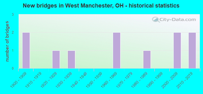
- New bridges - historical statistics
- 21900-1909
- 11920-1929
- 11930-1939
- 21960-1969
- 11980-1989
- 22000-2009
- 22010-2019
FCC Registered Antenna Towers:
5- David Ginter, Near 570 Wikel Road (Lat: 39.895556 Lon: -84.638472), Type: 78.9, Structure height: 39135 m, Overall height: 77.7 m, Registrant: Tag Towers, LLC, Dginter@tagtowers.Com, Suite 1, Richm-ond, Phone: (859) 544-5000
- David Ginter, Near 570 Wikel Road (Lat: 39.895556 Lon: -84.638472), Type: 78.9, Structure height: 39135 m, Overall height: 77.7 m, Registrant: Tag Towers, LLC, Dginter@tagtowers.Com, Suite 1, Richm-ond, Phone: (859) 544-5000
- David Ginter, Near 570 Wikel Road (Lat: 39.895556 Lon: -84.638472), Type: 78.9, Structure height: 39135 m, Overall height: 77.7 m, Registrant: Tag Towers, LLC, Dginter@tagtowers.Com, Suite 1, Richm-ond, Phone: (859) 544-5000
- David Ginter, Near 570 Wikel Road (Lat: 39.895556 Lon: -84.638472), Type: 78.9, Structure height: 39135 m, Overall height: 77.7 m, Registrant: Tag Towers, LLC, Dginter@tagtowers.Com, Suite 1, Richm-ond, Phone: (859) 544-5000
- David Ginter, Near 570 Wikel Road (Lat: 39.895556 Lon: -84.638472), Type: 78.9, Structure height: 39135 m, Overall height: 77.7 m, Registrant: Tag Towers, LLC, Dginter@tagtowers.Com, Suite 1, Richm-ond, Phone: (859) 544-5000
FCC Registered Broadcast Land Mobile Towers:
3- E Scott St (Lat: 39.903111 Lon: -84.627167), Call Sign: KQH303,
Assigned Frequencies: 154.190 MHz, Grant Date: 01/09/2014, Expiration Date: 11/16/2023, Cancellation Date: 01/20/2024, Registrant: Tech Elect & Comm, 319 No5th 5th Street, Richmond, IN 47374, Phone: (765) 966-0073, Fax: (800) 232-8224, Email:
- 1260 Stephens Rd (Lat: 39.885889 Lon: -84.654667), Call Sign: WRW359,
Assigned Frequencies: 154.490 MHz, Grant Date: 11/22/2022, Expiration Date: 11/20/2032, Registrant: 10118 Gettysburg Darke Rd, New Paris, OH 45347, Phone: (937) 533-1181
- Lat: 39.903639 Lon: -84.626556, Call Sign: WRNS978,
Assigned Frequencies: 462.000 MHz, 467.000 MHz, Grant Date: 08/18/2021, Expiration Date: 08/18/2031, Certifier: Charlie Montelongo, Registrant: Master Meter Inc., 101 Regency Parkway, Mansfield, TX 76063-5093, Phone: (817) 842-8000, Fax: (817) 842-8030, Email:
FCC Registered Microwave Towers:
1- W Man 1, Lat: 39.853056 Lon: -84.633889, Type: Silo, Structure height: 36.5 m, Call Sign: WQOJ973,
Assigned Frequencies: 3650.00 MHz, Grant Date: 10/22/2011, Expiration Date: 10/22/2021, Cancellation Date: 11/10/2021, Certifier: Nathan R Quante, Registrant: Blue Sky Wireless, LLC, Eaton, OH 45320, Phone: (937) 558-5678, Email:
FCC Registered Amateur Radio Licenses:
11 (See the full list of FCC Registered Amateur Radio Licenses in West Manchester)2003 - 2018 National Fire Incident Reporting System (NFIRS) incidents
- Fire incident types reported to NFIRS in West Manchester, OH
- 9659.3%Structure Fires
- 4829.6%Outside Fires
- 1811.1%Mobile Property/Vehicle Fires
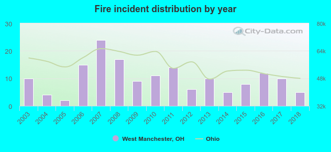 Based on the data from the years 2003 - 2018 the average number of fires per year is 10. The highest number of reported fires - 24 took place in 2007, and the least - 2 in 2005. The data has a decreasing trend.
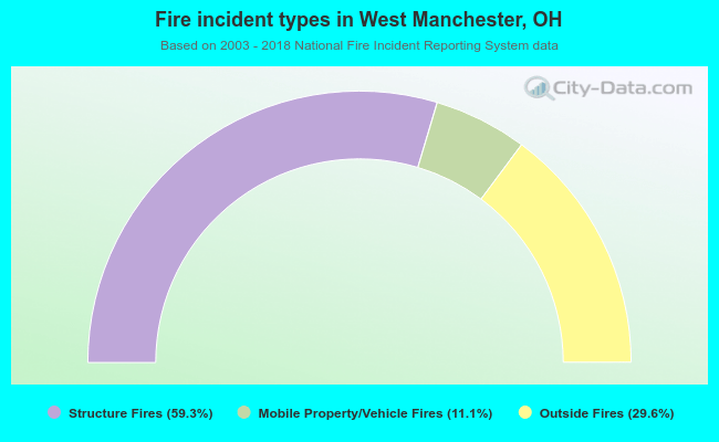 When looking into fire subcategories, the most reports belonged to: Structure Fires (59.3%), and Outside Fires (29.6%).
| Most common first names in West Manchester, OH among deceased individuals | ||
| Name | Count | Lived (average) |
|---|---|---|
| Mary | 12 | 82.5 years |
| William | 10 | 75.9 years |
| Robert | 9 | 72.1 years |
| James | 8 | 73.7 years |
| Edna | 7 | 87.3 years |
| Charles | 7 | 78.3 years |
| George | 6 | 75.6 years |
| John | 6 | 73.4 years |
| Harold | 4 | 83.0 years |
| Carl | 4 | 67.7 years |
| Most common last names in West Manchester, OH among deceased individuals | ||
| Last name | Count | Lived (average) |
|---|---|---|
| Brown | 6 | 77.5 years |
| Smith | 6 | 80.3 years |
| Gauch | 5 | 85.2 years |
| Turner | 5 | 85.2 years |
| Fitzwater | 4 | 89.3 years |
| Garner | 4 | 73.0 years |
| Baker | 4 | 63.7 years |
| Hensel | 4 | 80.5 years |
| Mcgriff | 4 | 78.5 years |
| Miller | 4 | 73.0 years |
West Manchester compared to Ohio state average:
- Median house value below state average.
- Unemployed percentage significantly below state average.
- Black race population percentage significantly below state average.
- Hispanic race population percentage significantly below state average.
- Median age below state average.
- Foreign-born population percentage significantly below state average.
- Length of stay since moving in significantly below state average.
- House age above state average.
- Percentage of population with a bachelor's degree or higher below state average.

|
|
Total of 8 patent applications in 2008-2024.