Weymouth Town, Massachusetts
Submit your own pictures of this city and show them to the world
- OSM Map
- Google Map
- MSN Map
| Males: 27,948 | |
| Females: 29,462 |
| Median resident age: | 44.5 years |
| Massachusetts median age: | 40.3 years |
Zip codes: 02188, 02189, 02190, 02191.
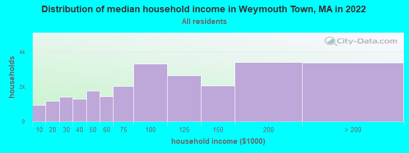
Weymouth Town Zip Code Map| Weymouth Town: | $115,969 |
| MA: | $94,488 |
Estimated per capita income in 2022: $66,166
Weymouth Town city income, earnings, and wages data
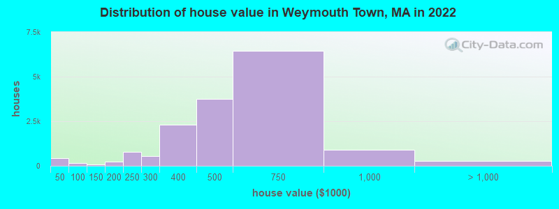
Estimated median house or condo value in 2022: $651,000
| Weymouth Town: | $651,000 |
| MA: | $534,700 |
Mean prices in 2022: all housing units: $516,286; detached houses: $562,341; townhouses or other attached units: $594,217; in 2-unit structures: $475,765; in 3-to-4-unit structures: $373,519; in 5-or-more-unit structures: $257,615; mobile homes: $141,897
Median gross rent in 2022: $1,739.
(5.9% for White Non-Hispanic residents, 1.8% for Black residents, 19.5% for Hispanic or Latino residents, 35.1% for American Indian residents, 2.4% for other race residents, 13.0% for two or more races residents)
Detailed information about poverty and poor residents in Weymouth Town, MA
Compare current foreclosures near your location:
| Photo | Address | Area | Beds / Baths | Price | Details |
|---|---|---|---|---|---|

|
#1
S High St
Columbus, OH 43207
|
1,678 sq. feet
|
2 baths 4 beds |
$31,900
|
show details |

|
#2
Bayberry Cir
Columbus, OH 43207
|
1,564 sq. feet
|
1 baths 3 beds |
$127,500
|
show details |

|
#3
E 21st Ave
Columbus, OH 43211
|
1,061 sq. feet
|
1 baths 3 beds |
$187,900
|
show details |

|
#4
Meadowbrook Dr
Columbus, OH 43207
|
1,752 sq. feet
|
2 baths 4 beds |
show details | |

|
#5
Bretton Pl
Columbus, OH 43211
|
1,056 sq. feet
|
1 baths 3 beds |
show details | |

|
#6
S Richardson Ave
Columbus, OH 43204
|
1,520 sq. feet
|
2 baths 3 beds |
show details | |

|
#7
Fergus Rd
Grove City, OH 43123
|
3,312 sq. feet
|
2 baths 4 beds |
show details | |

|
#8
High Free Pike
West Jefferson, OH 43162
|
1,216 sq. feet
|
2 baths 4 beds |
show details | |

|
#9
S Chillicothe St
Plain City, OH 43064
|
1,736 sq. feet
|
2 baths 4 beds |
show details | |

|
#10
Kingsglen Dr
Grove City, OH 43123
|
1,635 sq. feet
|
2 baths 4 beds |
show details |
| Photo | Address | Area | Beds / Baths | Price | Details |
|---|---|---|---|---|---|

|
#11
Derrer Rd -872
Columbus, OH 43204
|
1,667 sq. feet
|
2 baths 5 beds |
show details | |

|
#12
Mink St SW
Pataskala, OH 43062
|
1,442 sq. feet
|
1 baths 3 beds |
show details | |

|
#13
Hiawatha Park Dr
Columbus, OH 43211
|
1,278 sq. feet
|
1 baths 4 beds |
show details | |

|
#14
Rosewood Ct
Powell, OH 43065
|
2,801 sq. feet
|
3 baths 4 beds |
show details | |

|
#15
Ferris Rd
Columbus, OH 43224
|
2,218 sq. feet
|
3 baths 3 beds |
show details | |

|
#16
N Roys Ave
Columbus, OH 43204
|
1,248 sq. feet
|
2 baths 3 beds |
show details | |

|
#17
Falls Peak Ln
Delaware, OH 43015
|
1,352 sq. feet
|
2 baths 2 beds |
show details | |

|
#18
Midland Ave
Columbus, OH 43223
|
1,518 sq. feet
|
1 baths 2 beds |
show details | |

|
#19
Elaine Rd
Columbus, OH 43213
|
764 sq. feet
|
1 baths 2 beds |
show details | |

|
#20
Vineyard Haven Loop
Dublin, OH 43016
|
4,625 sq. feet
|
4 baths 4 beds |
show details |
| Photo | Address | Area | Beds / Baths | Price | Details |
|---|---|---|---|---|---|

|
#21
Wrexham Ave
Columbus, OH 43223
|
1,235 sq. feet
|
1 baths 3 beds |
show details | |

|
#22
Bunch Flower Ct
Westerville, OH 43082
|
3,173 sq. feet
|
2 baths 4 beds |
show details | |

|
#23
Mayflower Blvd
Columbus, OH 43213
|
1,591 sq. feet
|
2 baths 4 beds |
show details | |

|
#24
S Hague Ave
Columbus, OH 43204
|
979 sq. feet
|
1 baths 2 beds |
show details | |

|
#25
Arborlee Dr
Reynoldsburg, OH 43068
|
1,263 sq. feet
|
2 baths 3 beds |
show details | |

|
#26
Brookstone Dr
Westerville, OH 43082
|
1,783 sq. feet
|
3 baths 3 beds |
show details | |

|
#27
N Grener Ave
Columbus, OH 43228
|
1,120 sq. feet
|
1 baths 3 beds |
show details | |

|
#28
Bernadette Rd
Columbus, OH 43204
|
1,168 sq. feet
|
1 baths 3 beds |
show details | |

|
#29
Sleeping Meadow Dr
New Albany, OH 43054
|
3,211 sq. feet
|
2 baths 4 beds |
show details | |

|
#30
Belle Oak Dr
Galloway, OH 43119
|
1,296 sq. feet
|
2 baths 3 beds |
show details |
| Photo | Address | Area | Beds / Baths | Price | Details |
|---|---|---|---|---|---|

|
#31
Scottwood Rd
Columbus, OH 43227
|
1,008 sq. feet
|
1 baths 3 beds |
show details | |

|
#32
Fahlander Dr N
Columbus, OH 43229
|
1,338 sq. feet
|
2 baths 3 beds |
show details | |

|
#33
Stoneybrook Blvd # 21a
Hilliard, OH 43026
|
1,231 sq. feet
|
2 baths 3 beds |
show details | |

|
#34
Marshrun Dr
Grove City, OH 43123
|
2,036 sq. feet
|
2 baths 4 beds |
show details | |

|
#35
Spohn Dr
Westerville, OH 43081
|
1,040 sq. feet
|
1 baths 3 beds |
show details | |

|
#36
E Kanawha Ave
Columbus, OH 43214
|
1,230 sq. feet
|
1 baths 3 beds |
show details | |

|
#37
Oreily Dr
Galloway, OH 43119
|
1,533 sq. feet
|
2 baths 3 beds |
show details | |

|
#38
Pendent Ln
Columbus, OH 43207
|
1,260 sq. feet
|
2 baths 3 beds |
show details | |

|
#39
Conway Dr
Columbus, OH 43227
|
1,232 sq. feet
|
1 baths 3 beds |
show details | |

|
#40
Barthel Ave
Columbus, OH 43227
|
1,276 sq. feet
|
1 baths 3 beds |
show details |
| Photo | Address | Area | Beds / Baths | Price | Details |
|---|---|---|---|---|---|

|
#41
Ridgebury Dr
Hilliard, OH 43026
|
832 sq. feet
|
1 baths 2 beds |
show details | |

|
#42
Sandpiper Dr
Orient, OH 43146
|
2,219 sq. feet
|
2 baths 4 beds |
show details | |

|
#43
Leap Rd
Hilliard, OH 43026
|
1,352 sq. feet
|
1 baths 3 beds |
show details | |

|
#44
Messner Dr
Hilliard, OH 43026
|
832 sq. feet
|
1 baths 2 beds |
show details | |

|
#45
Illinois Ave
Westerville, OH 43081
|
1,120 sq. feet
|
1 baths 3 beds |
show details | |

|
#46
Mango Ln
Hilliard, OH 43026
|
1,024 sq. feet
|
1 baths 2 beds |
show details | |

|
#47
Tea Party Pl
Columbus, OH 43207
|
1,176 sq. feet
|
2 baths 3 beds |
show details | |

|
#48
Maroon Dr
Powell, OH 43065
|
1,198 sq. feet
|
2 baths 3 beds |
show details | |

|
#49
Windy Hill Ln
Galloway, OH 43119
|
1,108 sq. feet
|
2 baths 3 beds |
show details | |

|
Check over 1 million property listings on Foreclosure.com!
|
browse all offers | |||


- 44,34077.0%White alone
- 4,0357.0%Asian alone
- 3,1555.5%Black alone
- 2,6874.7%Hispanic
- 1,9023.3%Two or more races
- 1,0001.7%Other race alone
- 270.05%American Indian alone
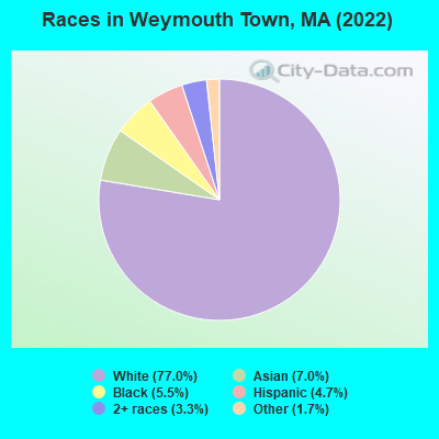
Races in Weymouth Town detailed stats: ancestries, foreign born residents, place of birth
 Recent articles from our blog. Our writers, many of them Ph.D. graduates or candidates, create easy-to-read articles on a wide variety of topics.

Ancestries: Irish (30.7%), Italian (7.6%), American (7.5%), English (3.6%), Brazilian (3.0%), Haitian (2.5%).
Current Local Time: EST time zone
8,454 residents are foreign born (5.6% Asia, 3.8% Latin America, 3.4% Europe).
| This city: | 14.7% |
| Massachusetts: | 17.6% |
Median real estate property taxes paid for housing units with mortgages in 2022: $4,808 (1.0%)
Median real estate property taxes paid for housing units with no mortgage in 2022: $4,814 (1.0%)
Nearest city with pop. 200,000+: Boston, MA  (10.8 miles , pop. 589,141).
Nearest city with pop. 1,000,000+: Bronx, NY (178.4 miles , pop. 1,332,650).
Nearest cities:
), ), Latitude: 42.21 N, Longitude: 70.95 W
| Here: | 3.5% |
| Massachusetts: | 3.5% |
(lower is better)
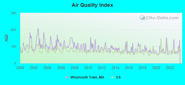
Air Quality Index (AQI) level in 2022 was 74.3. This is about average.
| City: | 74.3 |
| U.S.: | 72.6 |
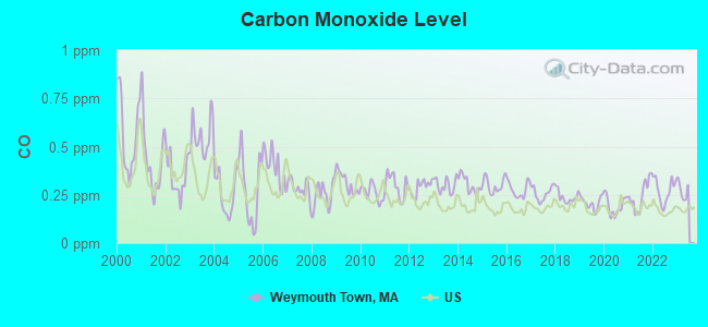
Carbon Monoxide (CO) [ppm] level in 2022 was 0.271. This is about average. Closest monitor was 2.9 miles away from the city center.
| City: | 0.271 |
| U.S.: | 0.251 |
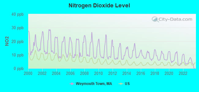
Nitrogen Dioxide (NO2) [ppb] level in 2022 was 5.61. This is about average. Closest monitor was 2.6 miles away from the city center.
| City: | 5.61 |
| U.S.: | 5.11 |
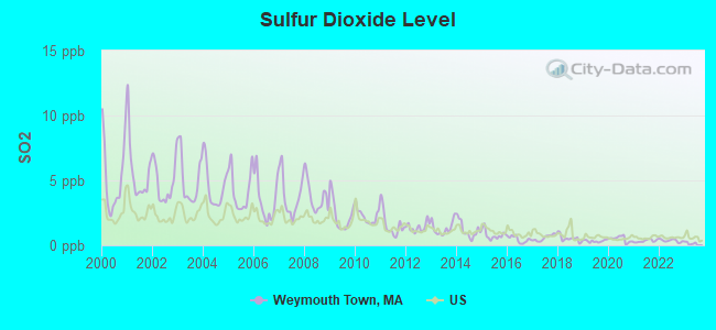
Sulfur Dioxide (SO2) [ppb] level in 2022 was 0.358. This is significantly better than average. Closest monitor was 2.9 miles away from the city center.
| City: | 0.358 |
| U.S.: | 1.515 |
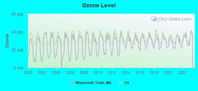
Ozone [ppb] level in 2022 was 31.3. This is about average. Closest monitor was 2.6 miles away from the city center.
| City: | 31.3 |
| U.S.: | 33.3 |
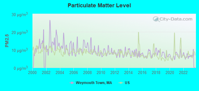
Particulate Matter (PM2.5) [µg/m3] level in 2022 was 6.42. This is better than average. Closest monitor was 2.6 miles away from the city center.
| City: | 6.42 |
| U.S.: | 8.11 |
Tornado activity:
Weymouth Town-area historical tornado activity is slightly below Massachusetts state average. It is 53% smaller than the overall U.S. average.
On 6/9/1953, a category F4 (max. wind speeds 207-260 mph) tornado 30.1 miles away from the Weymouth Town city center killed 90 people and injured 1228 people and caused between $50,000,000 and $500,000,000 in damages.
On 6/9/1953, a category F3 (max. wind speeds 158-206 mph) tornado 17.0 miles away from the city center injured 17 people and caused between $500,000 and $5,000,000 in damages.
Earthquake activity:
Weymouth Town-area historical earthquake activity is significantly above Massachusetts state average. It is 74% smaller than the overall U.S. average.On 10/7/1983 at 10:18:46, a magnitude 5.3 (5.1 MB, 5.3 LG, 5.1 ML, Class: Moderate, Intensity: VI - VII) earthquake occurred 209.8 miles away from the city center
On 4/20/2002 at 10:50:47, a magnitude 5.3 (5.3 ML, Depth: 3.0 mi) earthquake occurred 211.1 miles away from the city center
On 1/19/1982 at 00:14:42, a magnitude 4.7 (4.5 MB, 4.7 MD, 4.5 LG, Class: Light, Intensity: IV - V) earthquake occurred 95.4 miles away from the city center
On 10/16/2012 at 23:12:25, a magnitude 4.7 (4.7 ML, Depth: 10.0 mi) earthquake occurred 97.3 miles away from the city center
On 4/20/2002 at 10:50:47, a magnitude 5.2 (5.2 MB, 4.2 MS, 5.2 MW, 5.0 MW) earthquake occurred 210.5 miles away from Weymouth Town center
On 8/22/1992 at 12:20:32, a magnitude 4.8 (4.8 MB, 3.8 MS, 4.7 LG, Depth: 6.2 mi) earthquake occurred 217.0 miles away from Weymouth Town center
Magnitude types: regional Lg-wave magnitude (LG), body-wave magnitude (MB), duration magnitude (MD), local magnitude (ML), surface-wave magnitude (MS), moment magnitude (MW)
Natural disasters:
The number of natural disasters in Norfolk County (31) is a lot greater than the US average (15).Major Disasters (Presidential) Declared: 18
Emergencies Declared: 13
Causes of natural disasters: Floods: 12, Storms: 10, Hurricanes: 6, Snowstorms: 5, Snows: 3, Winter Storms: 3, Blizzards: 2, Explosion: 1, Heavy Rain: 1, Snowfall: 1, Tropical Storm: 1, Water Main Break: 1, Wind: 1 (Note: some incidents may be assigned to more than one category).
Hospitals and medical centers near Weymouth Town:
- WEYMOUTH HEALTH CARE CENTER (Nursing Home, about 1 miles away; WEYMOUTH, MA)
- POND MEADOW HEALTHCARE FACILITY (Nursing Home, about 1 miles away; WEYMOUTH, MA)
- COLONIAL NURSING REHAB CTR (Nursing Home, about 2 miles away; WEYMOUTH, MA)
- COLONIAL NURSING AND REHABILITATION CENTER (Nursing Home, about 2 miles away; WEYMOUTH, MA)
- WEYMOUTH DIALYSIS (Dialysis Facility, about 2 miles away; WEYMOUTH, MA)
- POPE NURSING HOME (Nursing Home, about 2 miles away; WEYMOUTH, MA)
- SAMUEL MARCUS NURSING HOME (Nursing Home, about 2 miles away; WEYMOUTH, MA)
Amtrak stations near Weymouth Town:
- 11 miles: ROUTE 128 (WESTWOOD, UNIVERSITY AVE. & RTE. 128) . Services: ticket office, enclosed waiting area, public restrooms, public payphones, vending machines, paid short-term parking, taxi stand, public transit connection.
- 12 miles: BOSTON (SO. STA) (BOSTON, ATLANTIC AVE. & SUMMER ST.) . Services: ticket office, fully wheelchair accessible, enclosed waiting area, public restrooms, public payphones, full-service food facilities and snack bar, ATM, paid short-term parking, paid long-term parking, call for car rental service, taxi stand, intercity bus service, public transit connection.
- 12 miles: BACK BAY (BOSTON, 145 DARTMOUTH ST.) . Services: ticket office, partially wheelchair accessible, enclosed waiting area, public restrooms, public payphones, vending machines, ATM, paid short-term parking, paid long-term parking, call for car rental service, taxi stand, public transit connection.
Colleges/universities with over 2000 students nearest to Weymouth Town:
- Quincy College (about 5 miles; Quincy, MA; Full-time enrollment: 3,184)
- University of Massachusetts-Boston (about 9 miles; Boston, MA; FT enrollment: 12,625)
- Curry College (about 9 miles; Milton, MA; FT enrollment: 2,586)
- Massasoit Community College (about 10 miles; Brockton, MA; FT enrollment: 5,442)
- Northeastern University (about 12 miles; Boston, MA; FT enrollment: 27,758)
- Wentworth Institute of Technology (about 12 miles; Boston, MA; FT enrollment: 4,418)
- MCPHS University (about 13 miles; Boston, MA; FT enrollment: 5,491)
Points of interest:
Notable locations in Weymouth Town: South Weymouth Station (A), Tirrell Playground (B), Negus Playground (C), Legion Field (D), Libby Field (E), Weymouth Village (F), Route 3 Industrial Park (G), Weymouth Industrial Park (H), Weymouth Fire Department Station 1 (I), Weymouth Fire Department Station 5 (J), Weymouth Fire Department Station 3 (K), Fogg Library (L), Weymouth Townhall (M), Weymouth Fire Department Station 2 Headquarters (N), Abigal Adams House Museum (O), Tufts Library (P), Weymouth Agricultural and Industrial Society (Q), Weymouth Historical Society (R). Display/hide their locations on the map
Shopping Centers: Pleasant Shops Shopping Center (1), Harborlight Mall (2), Harbor Light Mall Shopping Center (3), Pleasant Shops Shopping Center (4), Weymouth Shopping Center (5), Weymouth Village Shopping Center (6). Display/hide their locations on the map
Churches in Weymouth Town include: Ingreja Assembleia De Deus (A), Weymouth United Methodist Church (B), Unitarian Universalist Church (C), South Weymouth Church of the Nazarene (D), Saint Jerome Parish Hall (E), Saint Francis Xavier Church (F), Sacred Heart Parish Church (G), Pilgrim Congregational Church (H), Old South Union Congregational Church (I). Display/hide their locations on the map
Cemeteries: North Weymouth Cemetery (1), Village Cemetery (2), Fairmount Cemetery (3), Old North Cemetery (4), Elmwood Cemetery (5), Lakeview Cemetery (6), Highland Cemetery (7). Display/hide their locations on the map
Lakes, reservoirs, and swamps: Cranberry Pond (A), Elias Pond (B), Whortleberry Pond (C), Weymouth Great Pond (D), Whitmans Pond (E), Ellias Pond (F), Weymouth Back River Marshes (G), Weymouth Fore River Marshes (H). Display/hide their locations on the map
Rivers: Old Swamp River (A), Fresh River (B), Weymouth Back River (C), Mill River (D). Display/hide their locations on the map
Parks in Weymouth Town include: Webb Park (1), Beals Park (2), Weston Park (3), Lovell Playground (4), Newell Playground (5), Bradford Hawes Park (6), Clapp Memorial Park (7), William K Webb Park (8), Gagnon Park (9). Display/hide their locations on the map
Beach: Wessagusset Beach (A). Display/hide its location on the map
| This city: | 2.4 people |
| Massachusetts: | 2.5 people |
| This city: | 60.6% |
| Whole state: | 63.0% |
| This city: | 6.5% |
| Whole state: | 7.0% |
Likely homosexual households (counted as self-reported same-sex unmarried-partner households)
- Lesbian couples: 0.5% of all households
- Gay men: 0.3% of all households
People in group quarters in Weymouth Town in 2010:
- 373 people in nursing facilities/skilled-nursing facilities
- 56 people in emergency and transitional shelters (with sleeping facilities) for people experiencing homelessness
- 21 people in group homes intended for adults
- 10 people in other noninstitutional facilities
For population 15 years and over in Weymouth Town:
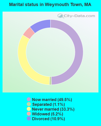
- Never married: 33.3%
- Now married: 49.5%
- Separated: 1.1%
- Widowed: 5.2%
- Divorced: 10.9%
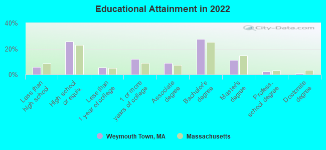
For population 25 years and over in Weymouth Town:
- High school or higher: 94.3%
- Bachelor's degree or higher: 40.9%
- Graduate or professional degree: 13.9%
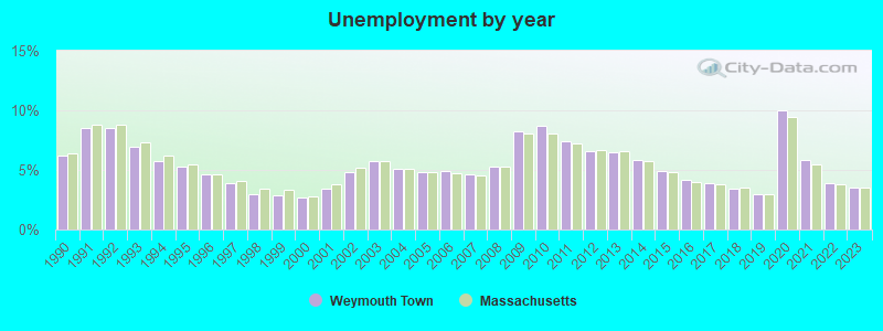
- Unemployed: 3.0%
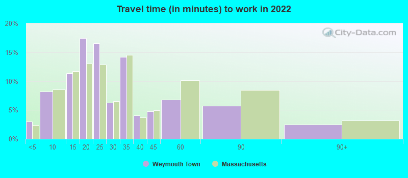
- Mean travel time to work (commute): 27.7 minutes
| Here: | 11.2 |
| Massachusetts average: | 13.0 |
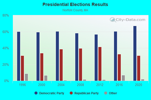
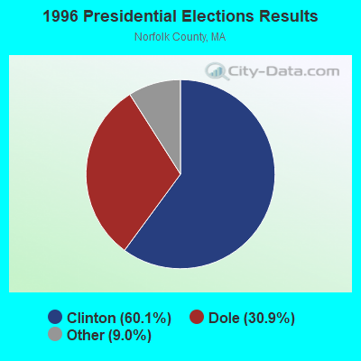
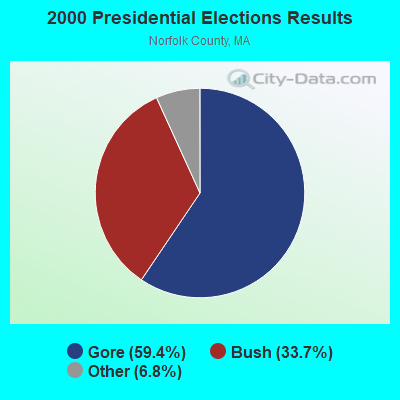
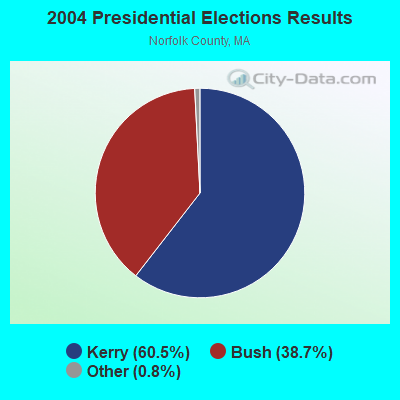
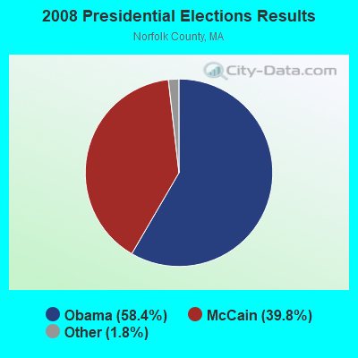
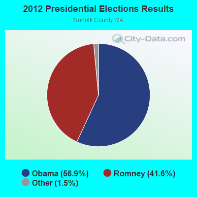

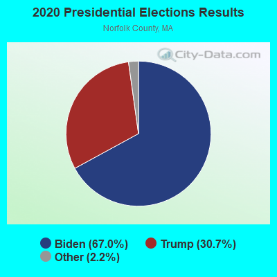
Graphs represent county-level data. Detailed 2008 Election Results
Religion statistics for Weymouth Town, MA (based on Norfolk County data)
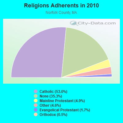
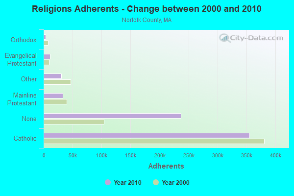
| Religion | Adherents | Congregations |
|---|---|---|
| Catholic | 355,321 | 52 |
| Mainline Protestant | 33,086 | 115 |
| Other | 30,593 | 75 |
| Evangelical Protestant | 11,323 | 89 |
| Orthodox | 3,539 | 9 |
| None | 236,988 | - |
Food Environment Statistics:
| This county: | 1.65 / 10,000 pop. |
| Massachusetts: | 1.98 / 10,000 pop. |
| Here: | 0.09 / 10,000 pop. |
| Massachusetts: | 0.05 / 10,000 pop. |
| Norfolk County: | 2.04 / 10,000 pop. |
| Massachusetts: | 2.22 / 10,000 pop. |
| This county: | 1.57 / 10,000 pop. |
| Massachusetts: | 1.77 / 10,000 pop. |
| This county: | 8.48 / 10,000 pop. |
| State: | 8.76 / 10,000 pop. |
| This county: | 7.1% |
| Massachusetts: | 8.1% |
| Norfolk County: | 19.1% |
| State: | 22.5% |
| Norfolk County: | 12.9% |
| State: | 16.5% |
| Local government employment and payroll (March 2022) | |||||
| Function | Full-time employees | Monthly full-time payroll | Average yearly full-time wage | Part-time employees | Monthly part-time payroll |
|---|---|---|---|---|---|
| Elementary and Secondary - Instruction | 855 | $5,106,526 | $71,671 | 215 | $74,683 |
| Elementary and Secondary - Other Total | 174 | $749,518 | $51,691 | 75 | $94,521 |
| Police Protection - Officers | 113 | $1,008,592 | $107,107 | 1 | $2,053 |
| Firefighters | 94 | $708,907 | $90,499 | 0 | $0 |
| Other and Unallocable | 48 | $260,836 | $65,209 | 1 | $786 |
| Water Supply | 34 | $199,951 | $70,571 | 1 | $1,115 |
| Streets and Highways | 33 | $180,638 | $65,687 | 0 | $0 |
| Financial Administration | 26 | $156,585 | $72,270 | 3 | $6,324 |
| Health | 22 | $149,436 | $81,511 | 1 | $673 |
| Parks and Recreation | 14 | $65,829 | $56,425 | 7 | $7,289 |
| Police - Other | 14 | $67,030 | $57,454 | 1 | $2,339 |
| Sewerage | 12 | $77,178 | $77,178 | 0 | $0 |
| Local Libraries | 12 | $63,775 | $63,775 | 5 | $5,789 |
| Welfare | 11 | $54,978 | $59,976 | 5 | $5,628 |
| Other Government Administration | 10 | $59,555 | $71,466 | 6 | $16,909 |
| Housing and Community Development (Local) | 5 | $38,335 | $92,004 | 0 | $0 |
| Judicial and Legal | 5 | $30,962 | $74,309 | 2 | $6,231 |
| Airports | 3 | $17,622 | $70,488 | 1 | $750 |
| Fire - Other | 2 | $11,647 | $69,882 | 0 | $0 |
| Totals for Government | 1,487 | $9,007,900 | $72,693 | 324 | $225,090 |
Weymouth Town government finances - Expenditure in 2021 (per resident):
- Current Operations - Elementary and Secondary Education: $103,105,000 ($1795.94)
General - Other: $23,714,000 ($413.06)
Sewerage: $14,646,000 ($255.11)
Police Protection: $13,060,000 ($227.49)
Local Fire Protection: $9,086,000 ($158.27)
Solid Waste Management: $5,494,000 ($95.70)
Water Utilities: $4,870,000 ($84.83)
Regular Highways: $3,057,000 ($53.25)
Financial Administration: $2,172,000 ($37.83)
Libraries: $1,522,000 ($26.51)
Central Staff Services: $1,418,000 ($24.70)
Housing and Community Development: $1,284,000 ($22.37)
Parks and Recreation: $807,000 ($14.06)
General Public Buildings: $775,000 ($13.50)
Judicial and Legal Services: $717,000 ($12.49)
Protective Inspection and Regulation - Other: $623,000 ($10.85)
Health - Other: $537,000 ($9.35)
Public Welfare - Other: $520,000 ($9.06)
Natural Resources - Other: $118,000 ($2.06)
- General - Interest on Debt: $2,883,000 ($50.22)
- Intergovernmental to Local - Other - Elementary and Secondary Education: $4,682,000 ($81.55)
Other - Health - Other: $146,000 ($2.54)
Other - Central Staff Services: $31,000 ($0.54)
- Intergovernmental to State - Transit Utilities: $1,293,000 ($22.52)
General - Other: $66,000 ($1.15)
- Other Capital Outlay - Elementary and Secondary Education: $52,203,000 ($909.30)
General - Other: $12,135,000 ($211.37)
Libraries: $9,929,000 ($172.95)
Regular Highways: $3,041,000 ($52.97)
General Public Building: $2,838,000 ($49.43)
Water Utilities: $529,000 ($9.21)
Sewerage: $497,000 ($8.66)
- Total Salaries and Wages: $66,583,000 ($1159.78)
- Water Utilities - Interest on Debt: $497,000 ($8.66)
Weymouth Town government finances - Revenue in 2021 (per resident):
- Charges - Sewerage: $19,351,000 ($337.07)
Other: $10,727,000 ($186.85)
Elementary and Secondary Education School Lunch: $760,000 ($13.24)
Elementary and Secondary Education - Other: $193,000 ($3.36)
Sea and Inland Port Facilities: $99,000 ($1.72)
- Federal Intergovernmental - Other: $9,951,000 ($173.33)
Housing and Community Development: $1,390,000 ($24.21)
Highways: $217,000 ($3.78)
- Miscellaneous - General Revenue - Other: $1,403,000 ($24.44)
Interest Earnings: $331,000 ($5.77)
Special Assessments: $64,000 ($1.11)
Fines and Forfeits: $39,000 ($0.68)
Donations From Private Sources: $11,000 ($0.19)
- Revenue - Water Utilities: $11,035,000 ($192.21)
- State Intergovernmental - Education: $38,960,000 ($678.63)
General Local Government Support: $10,379,000 ($180.79)
Other: $4,849,000 ($84.46)
Highways: $4,442,000 ($77.37)
Public Welfare: $350,000 ($6.10)
- Tax - Property: $124,728,000 ($2172.58)
Other License: $2,257,000 ($39.31)
Other Selective Sales: $1,420,000 ($24.73)
Weymouth Town government finances - Debt in 2021 (per resident):
- Long Term Debt - Outstanding Unspecified Public Purpose: $158,659,000 ($2763.61)
Issue, Unspecified Public Purpose: $100,065,000 ($1742.99)
Beginning Outstanding - Unspecified Public Purpose: $66,627,000 ($1160.55)
Retired Unspecified Public Purpose: $8,033,000 ($139.92)
- Short Term Debt Outstanding - Beginning: $37,190,000 ($647.80)
End of Fiscal Year: $9,417,000 ($164.03)
Weymouth Town government finances - Cash and Securities in 2021 (per resident):
- Bond Funds - Cash and Securities: $65,648,000 ($1143.49)
- Other Funds - Cash and Securities: $51,813,000 ($902.51)
8.01% of this county's 2021 resident taxpayers lived in other counties in 2020 ($110,572 average adjusted gross income)
| Here: | 8.01% |
| Massachusetts average: | 6.35% |
0.01% of residents moved from foreign countries ($78 average AGI)
Norfolk County: 0.01% Massachusetts average: 0.01%
Top counties from which taxpayers relocated into this county between 2020 and 2021:
| from Suffolk County, MA | |
| from Middlesex County, MA | |
| from Plymouth County, MA |
8.55% of this county's 2020 resident taxpayers moved to other counties in 2021 ($128,358 average adjusted gross income)
| Here: | 8.55% |
| Massachusetts average: | 7.18% |
0.01% of residents moved to foreign countries ($348 average AGI)
Norfolk County: 0.01% Massachusetts average: 0.02%
Top counties to which taxpayers relocated from this county between 2020 and 2021:
| to Suffolk County, MA | |
| to Middlesex County, MA | |
| to Plymouth County, MA |
Strongest AM radio stations in Weymouth Town:
- WBZ (1030 AM; 50 kW; BOSTON, MA; Owner: INFINITY BROADCASTING OPERATIONS, INC.)
- WEEI (850 AM; 50 kW; BOSTON, MA; Owner: ENTERCOM BOSTON LICENSE, LLC)
- WRKO (680 AM; 50 kW; BOSTON, MA; Owner: ENTERCOM BOSTON LICENSE, LLC)
- WWZN (1510 AM; 50 kW; BOSTON, MA; Owner: ROSE CITY RADIO CORPORATION)
- WMKI (1260 AM; 5 kW; BOSTON, MA; Owner: ABC, INC.)
- WUNR (1600 AM; 20 kW; BROOKLINE, MA; Owner: CHAMPION BROADCASTING SYSTEMS, INC.)
- WKOX (1200 AM; 50 kW; FRAMINGHAM, MA; Owner: CAPSTAR TX LIMITED PARTNERSHIP)
- WBIX (1060 AM; 40 kW; NATICK, MA; Owner: LANGER BROADCASTING CORPORATION)
- WRCA (1330 AM; 25 kW; WALTHAM, MA; Owner: WRCA LICENSE, LLC)
- WJDA (1300 AM; 1 kW; QUINCY, MA)
- WAMG (890 AM; 25 kW; DEDHAM, MA; Owner: MEGA COMMUNICATIONS OF DEDHAM LICENSEE, LLC)
- WALE (990 AM; 50 kW; GREENVILLE, RI; Owner: NORTH AMERICAN BROADCASTING CO., INC.)
- WEZE (590 AM; 5 kW; BOSTON, MA; Owner: NEW ENGLAND CONTINENTAL MEDIA, INC.)
Strongest FM radio stations in Weymouth Town:
- WXKS-FM (107.9 FM; MEDFORD, MA; Owner: AMFM RADIO LICENSES, L.L.C.)
- WMJX (106.7 FM; BOSTON, MA; Owner: GREATER BOSTON RADIO, INC.)
- WBMX (98.5 FM; BOSTON, MA; Owner: INFINITY RADIO OPERATIONS INC.)
- WBOS (92.9 FM; BROOKLINE, MA; Owner: GREATER BOSTON RADIO, INC.)
- WJMN (94.5 FM; BOSTON, MA; Owner: AMFM RADIO LICENSES, L.L.C.)
- WCRB (102.5 FM; WALTHAM, MA; Owner: CHARLES RIVER BROADCASTING WCRB LICE)
- WTKK (96.9 FM; BOSTON, MA; Owner: GREATER BOSTON RADIO, INC.)
- WROR-FM (105.7 FM; FRAMINGHAM, MA; Owner: GREATER BOSTON RADIO, INC.)
- WBCN (104.1 FM; BOSTON, MA; Owner: HEMISPHERE BROADCASTING CORPORATION)
- WZLX (100.7 FM; BOSTON, MA; Owner: INFINITY BROADCASTING CORPORATION OF BOSTON)
- W267AI (101.3 FM; BOSTON, MA; Owner: MCC BROADCASTING COMPANY, INC.)
- WERS (88.9 FM; BOSTON, MA; Owner: EMERSON COLLEGE)
- WGBH (89.7 FM; BOSTON, MA; Owner: WGBH EDUCATIONAL FOUNDATION)
- WBUR-FM (90.9 FM; BOSTON, MA; Owner: TRUSTEES OF BOSTON UNIVERSITY)
- WHRB (95.3 FM; CAMBRIDGE, MA; Owner: HARVARD RADIO BROADCASTING CO., INC.)
- WODS (103.3 FM; BOSTON, MA; Owner: INFINITY BROADCASTING OPERATIONS, INC.)
- WUMB-FM (91.9 FM; BOSTON, MA; Owner: THE UNIVERSITY OF MASSACHUSETTS)
- WBOT (97.7 FM; BROCKTON, MA; Owner: RADIO ONE LICENSES, LLC)
- WRPS (88.3 FM; ROCKLAND, MA; Owner: ROCKLAND PUBLIC SCHOOLS)
- WATD-FM (95.9 FM; MARSHFIELD, MA; Owner: MARSHFIELD BROADCASTING CO., INC.)
TV broadcast stations around Weymouth Town:
- WCVB-TV (Channel 5; BOSTON, MA; Owner: WCVB HEARST-ARGYLE TV, INC.)
- WGBH-TV (Channel 2; BOSTON, MA; Owner: WGBH EDUCATIONAL FOUNDATION)
- WBPX (Channel 68; BOSTON, MA; Owner: PAXSON BOSTON-68 LICENSE, INC.)
- WHDH-TV (Channel 7; BOSTON, MA; Owner: WHDH-TV)
- WMFP (Channel 62; LAWRENCE, MA; Owner: WSAH LICENSE, INC.)
- WSBK-TV (Channel 38; BOSTON, MA; Owner: VIACOM INC.)
- WLVI-TV (Channel 56; CAMBRIDGE, MA; Owner: WLVI, INC.)
- WFXT (Channel 25; BOSTON, MA; Owner: FOX TELEVISION STATIONS INC.)
- WBZ-TV (Channel 4; BOSTON, MA; Owner: VIACOM INC.)
- WGBX-TV (Channel 44; BOSTON, MA; Owner: WGBH EDUCATIONAL FOUNDATION)
- WWDP (Channel 46; NORWELL, MA; Owner: NORWELL TELEVISION, LLC)
- WTMU-LP (Channel 32; BOSTON, MA; Owner: ZGS BOSTON, INC.)
- WCEA-LP (Channel 58; BOSTON, MA; Owner: CHANNEL 19 TV CORPORATION)
- W40BO (Channel 40; BOSTON, MA; Owner: PAXSON COMMUNICATIONS LPTV, INC.)
- WUTF (Channel 66; MARLBOROUGH, MA; Owner: TELEFUTURA BOSTON LLC)
- WLNE-TV (Channel 6; NEW BEDFORD, MA; Owner: FREEDOM BROADCASTING OF SOUTHERN NEW ENGLAND, INC.)
- WPRI-TV (Channel 12; PROVIDENCE, RI; Owner: TVL BROADCASTING OF RHODE ISLAND, LLC)
- WNAC-TV (Channel 64; PROVIDENCE, RI; Owner: WNAC, LLC)
- WUNI (Channel 27; WORCESTER, MA; Owner: ENTRAVISION HOLDINGS, LLC)
- WJAR (Channel 10; PROVIDENCE, RI; Owner: OUTLET BROADCASTING, INC.)
- WSBE-TV (Channel 36; PROVIDENCE, RI; Owner: RHODE ISLAND PUBLIC TELECOM. AUTHORITY)
- WLWC (Channel 28; NEW BEDFORD, MA; Owner: C-28 FCC LICENSEE SUBSIDIARY, LLC)
- WFXZ-CA (Channel 24; BOSTON, MA; Owner: BOSTON BROADCASTING CORP.)
- National Bridge Inventory (NBI) Statistics
- 1Number of bridges
- 23ft / 6.7mTotal length
- $6,572,000Total costs
- 18,400Total average daily traffic
- 736Total average daily truck traffic
- 28,427Total future (year 2032) average daily traffic
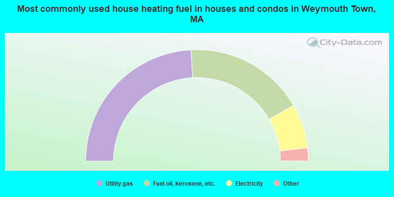
- 48.4%Utility gas
- 35.0%Fuel oil, kerosene, etc.
- 12.9%Electricity
- 2.5%Bottled, tank, or LP gas
- 0.6%Wood
- 0.4%No fuel used
- 0.2%Other fuel
- 0.1%Solar energy
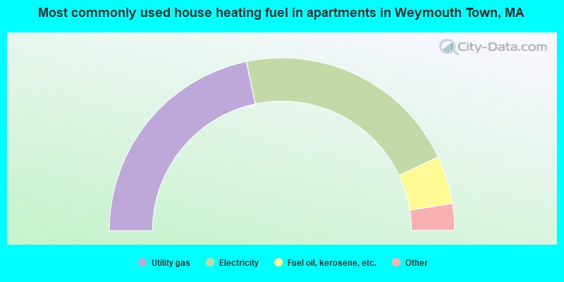
- 43.4%Utility gas
- 42.6%Electricity
- 9.0%Fuel oil, kerosene, etc.
- 3.2%Bottled, tank, or LP gas
- 1.5%No fuel used
- 0.2%Other fuel
- 0.1%Solar energy
Weymouth Town compared to Massachusetts state average:
- Unemployed percentage significantly below state average.
- Hispanic race population percentage below state average.
- Length of stay since moving in above state average.
Weymouth Town on our top lists:
- #1 on the list of "Top 101 cities with the highest average wind speeds (population 50,000+)"
- #19 on the list of "Top 101 cities with the most people born in the same U.S. state as the city (population 50,000+)"
- #22 on the list of "Top 101 cities with the lowest maximum monthly sunshine amount (population 50,000+)"
- #44 on the list of "Top 100 low-educated but high-earning cities (pop. 50,000+)"
- #49 on the list of "Top 101 cities with the smallest racial income disparities between White and Black householders (with at least 200 householders)"
- #50 on the list of "Top 101 cities with the largest wind speed differences during a year (population 50,000+)"
- #52 on the list of "Top 101 cities with largest percentage of males in industries: finance and insurance (population 50,000+)"
- #55 on the list of "Top 101 cities with the smallest sunshine amount differences during a year (population 50,000+)"
- #56 on the list of "Top 101 cities with largest percentage of males in occupations: business and financial operations occupations (population 50,000+)"
- #59 on the list of "Top 101 cities with largest percentage of females in occupations: health diagnosing and treating practitioners and other technical occupations (population 50,000+)"
- #61 on the list of "Top 101 cities with largest percentage of females in industries: health care and social assistance (population 50,000+)"
- #69 on the list of "Top 101 cities with largest percentage of females in industries: finance and insurance (population 50,000+)"
- #81 on the list of "Top 100 cities with oldest residents (pop. 50,000+)"
- #81 on the list of "Top 100 cities with longest commuting times (pop. 50,000+)"
- #82 on the list of "Top 101 cities with the smallest precipitation differences during a year (population 50,000+)"
- #90 on the list of "Top 100 least racially diverse cities (pop. 50,000+)"
- #93 on the list of "Top 100 cities with the largest percentage of females (pop. 50,000+)"
- #97 on the list of "Top 101 cities with largest percentage of females in occupations: computer and mathematical occupations (population 50,000+)"
- #97 on the list of "Top 101 cities with the lowest average sunshine amount (population 50,000+)"
- #97 on the list of "Top 100 cities with highest median household income (pop. 50,000+)"
- #4 (02190) on the list of "Top 101 zip codes with the largest percentage of Irish first ancestries (pop 5,000+)"
- #7 on the list of "Top 101 counties with the highest percentage of residents that visited a dentist within the past year"
- #12 on the list of "Top 101 counties with the lowest percentage of residents that keep firearms around their homes"
- #13 on the list of "Top 101 counties with the best general health status score of residents (1-5), 3 years of data"
- #18 on the list of "Top 101 counties with the lowest Nitrogen Dioxide air pollution readings in 2012 (ppm)"
- #25 on the list of "Top 101 counties with the lowest number of infant deaths per 1000 residents 2007-2013 (pop. 50,000+)"