Willimantic, Maine
Submit your own pictures of this town and show them to the world
- OSM Map
- General Map
- Google Map
- MSN Map
Population change since 2000: +11.1%
 |
| Males: 74 | |
| Females: 76 |
| Median resident age: | 52.0 years |
| Maine median age: | 43.0 years |
Zip code: 04443
| Willimantic: | $49,049 |
| ME: | $69,543 |
Estimated per capita income in 2022: $33,660 (it was $14,206 in 2000)
Estimated median house or condo value in 2022: $109,748 (it was $42,200 in 2000)
| Willimantic: | $109,748 |
| ME: | $290,600 |
Mean prices in 2022: all housing units: $203,844; detached houses: $217,964; townhouses or other attached units: $250,113; in 2-unit structures: $253,343; in 3-to-4-unit structures: $283,591; in 5-or-more-unit structures: $146,783; mobile homes: $82,683
Detailed information about poverty and poor residents in Willimantic, ME
Compare current foreclosures near Willimantic, ME:
| Photo | Address | Area | Beds / Baths | Price | Details |
|---|---|---|---|---|---|

|
#1
Grange St
Dover Foxcroft, ME 04426
|
- sq. feet
|
4 baths 4 beds |
show details | |

|
#2
Range Rd
Dover Foxcroft, ME 04426
|
- sq. feet
|
- baths - beds |
show details | |

|
#3
Range Rd
Dover Foxcroft, ME 04426
|
- sq. feet
|
- baths - beds |
show details | |

|
#4
Milo Rd
Sebec, ME 04481
|
- sq. feet
|
- baths - beds |
show details | |

|
Check over 1 million property listings on Foreclosure.com!
|
browse all offers | |||

- 14798.0%White alone
- 21.3%American Indian alone
- 10.7%Two or more races

According to our research of Maine and other state lists, there were 2 registered sex offenders living in Willimantic, Maine as of April 19, 2024.
The ratio of all residents to sex offenders in Willimantic is 75 to 1.
 Recent articles from our blog. Our writers, many of them Ph.D. graduates or candidates, create easy-to-read articles on a wide variety of topics.


 | Hows maine (44 replies) |
| Vermont vs Maine for Retirement (25 replies) |
| What counties have you lived in Maine? (15 replies) |
| Bangor area Internet connectivity (12 replies) |
Latest news from Willimantic, ME collected exclusively by city-data.com from local newspapers, TV, and radio stations
Ancestries: French (27.4%), English (24.4%), Scottish (11.1%), Irish (8.1%), United States (7.4%), German (6.7%).
Current Local Time: EST time zone
Incorporated on 02/22/1881
Elevation: 395 feet
Land area: 43.5 square miles.
Population density: 3.4 people per square mile (very low).
3 residents are foreign born (2.2% Europe).
| This town: | 2.2% |
| Maine: | 2.9% |
| Willimantic town: | 0.8% ($338) |
| Maine: | 1.5% ($1,417) |
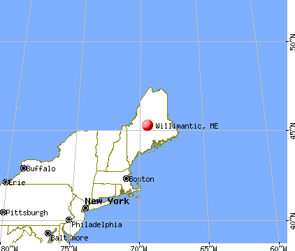
Nearest city with pop. 50,000+: Portland, ME  (121.5 miles , pop. 64,249).
Nearest city with pop. 200,000+: Boston, MA (223.2 miles , pop. 589,141).
Nearest city with pop. 1,000,000+: Bronx, NY (382.7 miles , pop. 1,332,650).
Nearest cities:
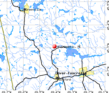
), Latitude: 45.30 N, Longitude: 69.38 W
Area code commonly used in this area: 207


Single-family new house construction building permits:
- 2009: 1 building, cost: $178,900
- 2008: 2 buildings, average cost: $182,400
- 2005: 1 building, cost: $60,000
- 2004: 1 building, cost: $60,000
- 2003: 1 building, cost: $60,000
- 1999: 1 building, cost: $40,000


| Here: | 7.5% |
| Maine: | 3.4% |


- Furniture & related product manufacturing (13.0%)
- Agriculture, forestry, fishing & hunting (11.1%)
- Arts, entertainment, recreation (11.1%)
- Accommodation & food services (11.1%)
- Public administration (9.3%)
- Wood products (5.6%)
- Data processing, libraries, other information services (5.6%)

- Agriculture, forestry, fishing & hunting (20.0%)
- Furniture & related product manufacturing (16.7%)
- Wood products (10.0%)
- Arts, entertainment, recreation (10.0%)
- Accommodation & food services (10.0%)
- Furniture & home furnishings, household appliance stores (6.7%)
- Construction (6.7%)

- Public administration (12.5%)
- Data processing, libraries, other information services (12.5%)
- Arts, entertainment, recreation (12.5%)
- Accommodation & food services (12.5%)
- Furniture & related product manufacturing (8.3%)
- Textile mills & textile products (8.3%)
- Professional, scientific, technical services (8.3%)

- Transportation, tourism, and lodging attendants (11.1%)
- Agricultural workers, including supervisors (11.1%)
- Building and grounds cleaning and maintenance occupations (9.3%)
- Top executives (5.6%)
- Librarians, curators, and archivists (5.6%)
- Woodworkers (5.6%)
- Other production occupations, including supervisors (5.6%)

- Agricultural workers, including supervisors (20.0%)
- Building and grounds cleaning and maintenance occupations (10.0%)
- Transportation, tourism, and lodging attendants (10.0%)
- Woodworkers (10.0%)
- Other production occupations, including supervisors (10.0%)
- Law enforcement workers, including supervisors (6.7%)
- Retail sales workers, except cashiers (6.7%)

- Top executives (12.5%)
- Librarians, curators, and archivists (12.5%)
- Transportation, tourism, and lodging attendants (12.5%)
- Other teachers, instructors, education, training, and library occupations (8.3%)
- Building and grounds cleaning and maintenance occupations (8.3%)
- Nursing, psychiatric, and home health aides (8.3%)
- Supervisors and other personal care and service workers, except child care workers (8.3%)
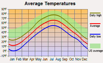
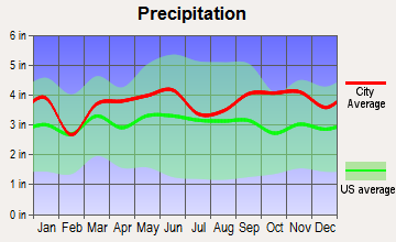
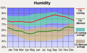
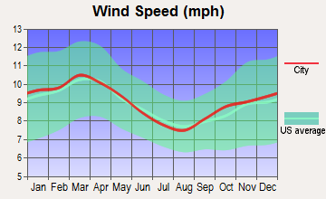
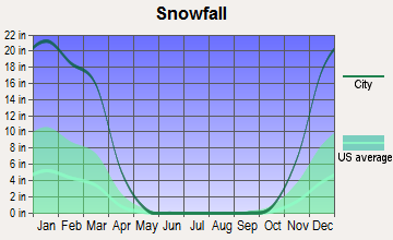
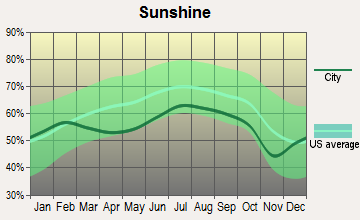
Average climate in Willimantic, Maine
Based on data reported by over 4,000 weather stations
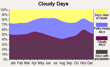
(lower is better)

Air Quality Index (AQI) level in 2010 was 43.8. This is significantly better than average.
| City: | 43.8 |
| U.S.: | 72.6 |

Ozone [ppb] level in 2001 was 28.8. This is about average. Closest monitor was 12.5 miles away from the city center.
| City: | 28.8 |
| U.S.: | 33.3 |

Particulate Matter (PM2.5) [µg/m3] level in 2010 was 4.31. This is significantly better than average. Closest monitor was 15.2 miles away from the city center.
| City: | 4.31 |
| U.S.: | 8.11 |
Earthquake activity:
Willimantic-area historical earthquake activity is significantly above Maine state average. It is 81% smaller than the overall U.S. average.On 4/20/2002 at 10:50:47, a magnitude 5.3 (5.3 ML, Depth: 3.0 mi, Class: Moderate, Intensity: VI - VII) earthquake occurred 218.4 miles away from Willimantic center
On 4/20/2002 at 10:50:47, a magnitude 5.2 (5.2 MB, 4.2 MS, 5.2 MW, 5.0 MW) earthquake occurred 219.9 miles away from the city center
On 10/16/2012 at 23:12:25, a magnitude 4.7 (4.7 ML, Depth: 10.0 mi, Class: Light, Intensity: IV - V) earthquake occurred 133.7 miles away from Willimantic center
On 10/7/1983 at 10:18:46, a magnitude 5.3 (5.1 MB, 5.3 LG, 5.1 ML) earthquake occurred 261.5 miles away from Willimantic center
On 1/19/1982 at 00:14:42, a magnitude 4.7 (4.5 MB, 4.7 MD, 4.5 LG) earthquake occurred 166.1 miles away from Willimantic center
On 2/26/1999 at 03:38:43, a magnitude 3.8 (3.8 LG, Depth: 2.0 mi, Class: Light, Intensity: II - III) earthquake occurred 57.3 miles away from Willimantic center
Magnitude types: regional Lg-wave magnitude (LG), body-wave magnitude (MB), duration magnitude (MD), local magnitude (ML), surface-wave magnitude (MS), moment magnitude (MW)
Natural disasters:
The number of natural disasters in Piscataquis County (22) is greater than the US average (15).Major Disasters (Presidential) Declared: 15
Emergencies Declared: 6
Causes of natural disasters: Floods: 13, Storms: 12, Snows: 7, Heavy Rains: 2, Blizzard: 1, Ice Storm: 1, Landslide: 1, Snowfall: 1, Wind: 1, Winter Storm: 1, Other: 2 (Note: some incidents may be assigned to more than one category).
Airports located in Willimantic:
- Two Falls Airport (ME79) (Runways: 2)
Colleges/universities with over 2000 students nearest to Willimantic:
- Husson University (about 44 miles; Bangor, ME; Full-time enrollment: 2,421)
- University of Maine (about 45 miles; Orono, ME; FT enrollment: 8,931)
- University of Maine at Farmington (about 58 miles; Farmington, ME; FT enrollment: 2,036)
- University of Maine at Augusta (about 70 miles; Augusta, ME; FT enrollment: 3,204)
- Saint Joseph's College of Maine (about 116 miles; Standish, ME; FT enrollment: 2,010)
- University of Southern Maine (about 122 miles; Portland, ME; FT enrollment: 6,647)
- Southern Maine Community College (about 122 miles; South Portland, ME; FT enrollment: 4,666)
Points of interest:
Cemetery: Riverside Cemetery (1). Display/hide its location on the map
Lakes and swamps: Badger Pond (A), Big Benson Pond (B), Fourth Davis Pond (C), Garcock Pond (D), Grindstone Pond (E), Horseshoe Pond (F), Little Bennett Pond (G), Mud Greenwood Pond (H). Display/hide their locations on the map
Streams, rivers, and creeks: Badger Brook (A), Ship Pond Stream (B), Salmon Stream (C), Hathaway Brook (D), Grindstone Brook (E), Eighteen Pond Brook (F), Ledge Hill Brook (G), Monson Stream (H), Ice Cave Brook (I). Display/hide their locations on the map
| This town: | 2.2 people |
| Maine: | 2.3 people |
| This town: | 62.3% |
| Whole state: | 62.9% |
| This town: | 10.1% |
| Whole state: | 9.4% |
Likely homosexual households (counted as self-reported same-sex unmarried-partner households)
- Lesbian couples: 0.0% of all households
- Gay men: 1.4% of all households
| This town: | 26.6% |
| Whole state: | 10.9% |
| This town: | 1.4% |
| Whole state: | 4.1% |
For population 15 years and over in Willimantic:

- Never married: 21.1%
- Now married: 53.7%
- Separated: 0.0%
- Widowed: 9.8%
- Divorced: 15.4%
For population 25 years and over in Willimantic:
- High school or higher: 67.3%
- Bachelor's degree or higher: 16.3%
- Graduate or professional degree: 2.9%
- Unemployed: 12.9%
- Mean travel time to work (commute): 18.0 minutes


| Here: | 13.6 |
| Maine average: | 11.2 |
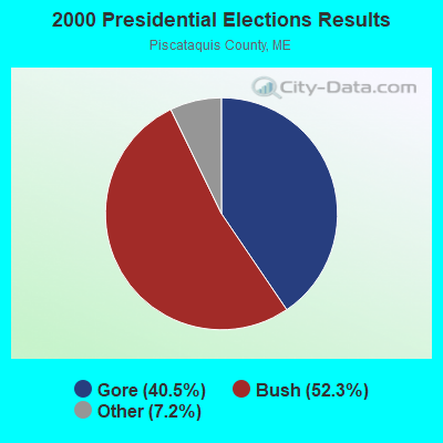
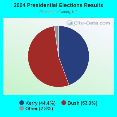
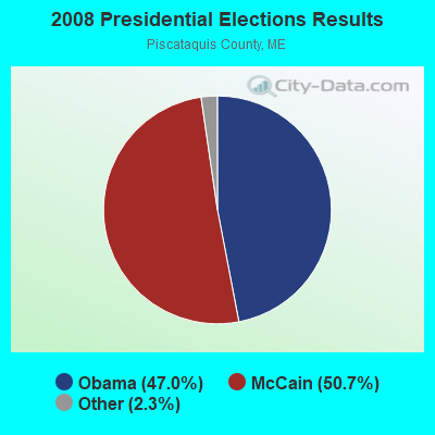
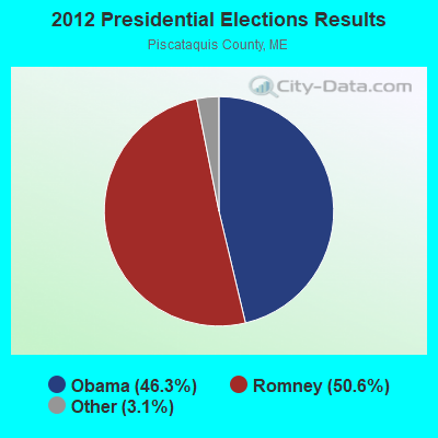
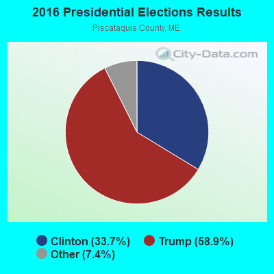
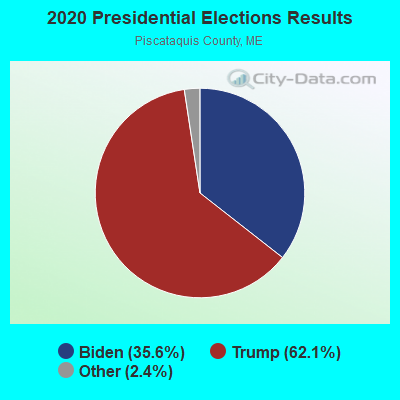
Graphs represent county-level data. Detailed 2008 Election Results
Religion statistics for Willimantic, ME (based on Piscataquis County data)
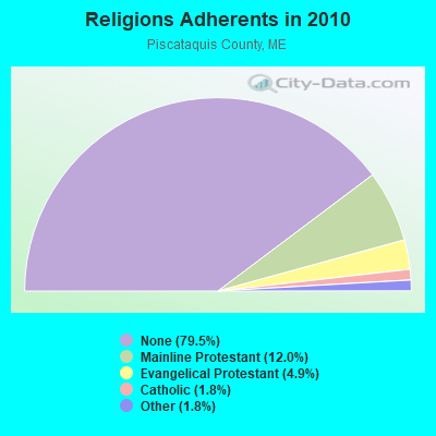
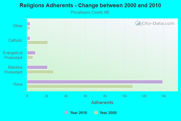
| Religion | Adherents | Congregations |
|---|---|---|
| Mainline Protestant | 2,108 | 13 |
| Evangelical Protestant | 855 | 13 |
| Catholic | 320 | 3 |
| Other | 318 | 5 |
| None | 13,934 | - |
Food Environment Statistics:
| Piscataquis County: | 5.24 / 10,000 pop. |
| Maine: | 2.80 / 10,000 pop. |
| Piscataquis County: | 4.08 / 10,000 pop. |
| State: | 2.20 / 10,000 pop. |
| Here: | 8.74 / 10,000 pop. |
| Maine: | 5.75 / 10,000 pop. |
| Piscataquis County: | 10.49 / 10,000 pop. |
| Maine: | 11.02 / 10,000 pop. |
| Piscataquis County: | 8.4% |
| Maine: | 8.2% |
| This county: | 27.5% |
| State: | 25.0% |
Strongest AM radio stations in Willimantic:
- WSKW (1160 AM; 10 kW; SKOWHEGAN, ME; Owner: MOUNTAIN WIRELESS, INCORPORATED)
- WZON (620 AM; 5 kW; BANGOR, ME; Owner: THE ZONE CORPORATION)
- WABI (910 AM; 5 kW; BANGOR, ME; Owner: CLEAR CHANNEL BROADCASTING LICENSES, INC.)
- WTME (780 AM; 10 kW; RUMFORD, ME; Owner: MOUNTAIN VALLEY BROADCASTING, INC.)
- WRKO (680 AM; 50 kW; BOSTON, MA; Owner: ENTERCOM BOSTON LICENSE, LLC)
- WCHP (760 AM; 35 kW; CHAMPLAIN, NY; Owner: CHAMPLAIN RADIO, INC.)
- WEEI (850 AM; 50 kW; BOSTON, MA; Owner: ENTERCOM BOSTON LICENSE, LLC)
- WNNZ (640 AM; 50 kW; WESTFIELD, MA; Owner: CLEAR CHANNEL BROADCASTING LICENSES, INC.)
- WBZ (1030 AM; 50 kW; BOSTON, MA; Owner: INFINITY BROADCASTING OPERATIONS, INC.)
- WCRN (830 AM; 50 kW; WORCESTER, MA; Owner: CARTER BROADCASTING CORPORATION)
- WKOX (1200 AM; 50 kW; FRAMINGHAM, MA; Owner: CAPSTAR TX LIMITED PARTNERSHIP)
- WALE (990 AM; 50 kW; GREENVILLE, RI; Owner: NORTH AMERICAN BROADCASTING CO., INC.)
- WGY (810 AM; 50 kW; SCHENECTADY, NY; Owner: CLEAR CHANNEL BROADCASTING LICENSES, INC.)
Strongest FM radio stations in Willimantic:
- WQCB (106.5 FM; BREWER, ME; Owner: CUMULUS LICENSING CORP.)
- WDME-FM (103.1 FM; DOVER-FOXCROFT, ME; Owner: THE ZONE CORPORATION)
- WTOS-FM (105.1 FM; SKOWHEGAN, ME; Owner: CAPSTAR TX LIMITED PARTNERSHIP)
- WGUY (102.1 FM; DEXTER, ME; Owner: CONCORD MEDIA GROUP, INC.)
- WVOM (103.9 FM; HOWLAND, ME; Owner: CLEAR CHANNEL BROADCASTING LICENSES, INC.)
- WHCF (88.5 FM; BANGOR, ME; Owner: BANGOR BAPTIST CHURCH)
- WWBX (97.1 FM; BANGOR, ME; Owner: CLEAR CHANNEL BROADCASTING LICENSES, INC.)
TV broadcast stations around Willimantic:
- W27CE (Channel 19; DOVER-FOXCROFT, ME; Owner: TRINITY BROADCASTING NETWORK)
FCC Registered Amateur Radio Licenses:
2- Call Sign: KC2BME, Licensee ID: L00401317, Grant Date: 03/31/2017, Expiration Date: 05/31/2027, Registrant: Mark S Halupa, 491 Sebec Lake Rd, Willimantic, ME 04443
- Call Sign: KB1ZQY, Licensee ID: L01779756, Grant Date: 04/09/2013, Expiration Date: 04/09/2023, Certifier: Thomas M Capraro, Registrant: Thomas M Capraro, 447 Sebec Lake Rd, Willimantic, ME 04443
FAA Registered Aircraft:
4- Aircraft: CESSNA 185D (Category: Land, Seats: 6, Weight: Up to 12,499 Pounds, Speed: 125 mph), Engine: CONT MOTOR I0-470 SERIES (260 HP) (Reciprocating)
N-Number: 1557F, N1557F, N-1557F, Serial Number: 185-0928, Year manufactured: 1965, Airworthiness Date: 06/19/1965, Certificate Issue Date: 11/10/2020
Registrant (Individual): Charles C Jr Feaga, 988 Sebec Lake Rd, Willimantic, ME 04443 - Aircraft: CESSNA A185F (Category: Land, Seats: 6, Weight: Up to 12,499 Pounds, Speed: 127 mph), Engine: Reciprocating
N-Number: 9411H, N9411H, N-9411H, Serial Number: 18503437, Certificate Issue Date: 02/08/2019
Registrant (Individual): Charles C Feaga, 988 Sebec Lake Rd, Willimantic, ME 04443
Deregistered: Cancel Date: 11/06/2018 - Aircraft: CESSNA 182D (Category: Land, Seats: 4, Weight: Up to 12,499 Pounds, Speed: 119 mph), Engine: CONT MOTOR O-470 SERIES (230 HP) (Reciprocating)
N-Number: 9089X, N9089X, N-9089X, Serial Number: 18253489, Year manufactured: 1961, Certificate Issue Date: 12/19/2013
Registrant (Corporation): Sebec Avaition Servcies LLC, 988 Sebec Lake Rd, Willimantic, ME 04443
Deregistered: Cancel Date: 03/16/2018 - Aircraft: CESSNA 172N (Category: Land, Seats: 4, Weight: Up to 12,499 Pounds, Speed: 105 mph), Engine: LYCOMING 0-320 SERIES (180 HP) (Reciprocating)
N-Number: 76101, N76101, N-76101, Serial Number: 17268124, Airworthiness Date: 12/08/1976, Certificate Issue Date: 03/11/2016
Registrant (Corporation): Ccf Ventures Inc, 988 Sebec Lake Rd, Willimantic, ME 04443

- 58.0%Fuel oil, kerosene, etc.
- 36.0%Wood
- 6.0%Bottled, tank, or LP gas

- 75.0%Wood
- 25.0%Fuel oil, kerosene, etc.
Willimantic compared to Maine state average:
- Median house value significantly below state average.
- Black race population percentage significantly below state average.
- Hispanic race population percentage significantly below state average.
- Median age significantly above state average.
- Foreign-born population percentage below state average.
- Renting percentage significantly below state average.
- Length of stay since moving in significantly above state average.
- Number of rooms per house significantly below state average.
- House age significantly below state average.
- Percentage of population with a bachelor's degree or higher below state average.