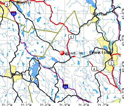
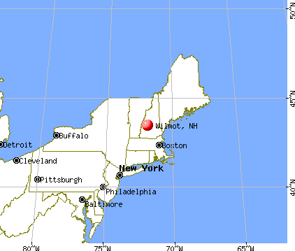
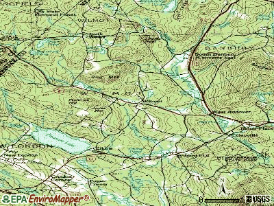
Wilmot, New Hampshire
Submit your own pictures of this town and show them to the world
- OSM Map
- General Map
- Google Map
- MSN Map
Population change since 2000: +18.7%
 |
| Males: 670 | |
| Females: 688 |
| Median resident age: | 46.6 years |
| New Hampshire median age: | 43.9 years |
Zip codes: 03287.
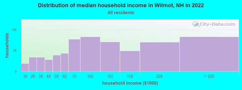
| Wilmot: | $86,580 |
| NH: | $89,992 |
Estimated per capita income in 2022: $51,338 (it was $25,629 in 2000)
Wilmot town income, earnings, and wages data
Estimated median house or condo value in 2022: $457,213 (it was $146,100 in 2000)
| Wilmot: | $457,213 |
| NH: | $384,700 |
Mean prices in 2022: all housing units: $378,901; detached houses: $416,256; townhouses or other attached units: $317,750; in 2-unit structures: $298,869; in 3-to-4-unit structures: $371,619; in 5-or-more-unit structures: $216,601; mobile homes: $110,180; occupied boats, rvs, vans, etc.: $74,347
Detailed information about poverty and poor residents in Wilmot, NH
Compare current foreclosures near Wilmot, NH:
| Photo | Address | Area | Beds / Baths | Price | Details |
|---|---|---|---|---|---|

|
#1
Nh Route 4a
Wilmot, NH 03287
|
- sq. feet
|
- baths - beds |
show details | |

|
#2
S Main St
Newport, NH 03773
|
100 sq. feet
|
1 baths 1 beds |
$60,000
|
show details |

|
#3
Jolly Farm Rd
Bradford, NH 03221
|
- sq. feet
|
1 baths 3 beds |
show details | |

|
#4
Forest St
Bradford, NH 03221
|
1,009 sq. feet
|
1 baths 2 beds |
show details | |

|
#5
Ryder Corner Rd
Sunapee, NH 03782
|
1,248 sq. feet
|
1 baths 3 beds |
show details | |

|
#6
Elm St
Tilton, NH 03276
|
855 sq. feet
|
1 baths 2 beds |
show details | |

|
#7
Cross Mill Rd
Tilton, NH 03276
|
1,508 sq. feet
|
2 baths 3 beds |
show details | |

|
#8
Valley Of Industry
Concord, NH 03303
|
2,703 sq. feet
|
1 baths 4 beds |
show details | |

|
#9
Brook Rd # 2
Sanbornton, NH 03269
|
2,128 sq. feet
|
2 baths 4 beds |
show details | |

|
#10
Ryder Corner Rd
Sunapee, NH 03782
|
1,508 sq. feet
|
2 baths 3 beds |
show details |
| Photo | Address | Area | Beds / Baths | Price | Details |
|---|---|---|---|---|---|

|
#11
Duck Pond Ln
Warner, NH 03278
|
1,120 sq. feet
|
1 baths 3 beds |
show details | |

|
#12
Knights Hill Rd
New London, NH 03257
|
3,024 sq. feet
|
2 baths 4 beds |
show details | |

|
#13
Shaw Hill Rd
Sanbornton, NH 03269
|
1,976 sq. feet
|
1 baths 3 beds |
show details | |

|
#14
Bullocks Crossing Rd
Grafton, NH 03240
|
- sq. feet
|
- baths - beds |
show details | |

|
#15
County Rd
Bradford, NH 03221
|
- sq. feet
|
- baths - beds |
show details | |

|
#16
Bowman Rd
Springfield, NH 03284
|
- sq. feet
|
- baths - beds |
show details | |

|
#17
Prospect St Apt 2
Tilton, NH 03276
|
- sq. feet
|
- baths - beds |
show details | |

|
#18
Corn Hill Rd
Concord, NH 03303
|
- sq. feet
|
- baths - beds |
show details | |

|
#19
High St
Bradford, NH 03221
|
- sq. feet
|
- baths - beds |
show details | |

|
#20
Blood Rd
Newport, NH 03773
|
- sq. feet
|
- baths - beds |
show details |
| Photo | Address | Area | Beds / Baths | Price | Details |
|---|---|---|---|---|---|

|
#21
River St Apt 1k
Franklin, NH 03235
|
- sq. feet
|
- baths - beds |
show details | |

|
#22
Scribner Rd # 78
Tilton, NH 03276
|
- sq. feet
|
- baths - beds |
show details | |

|
#23
Central St
Franklin, NH 03235
|
- sq. feet
|
- baths - beds |
show details | |

|
#24
Peverly Rd
Tilton, NH 03276
|
- sq. feet
|
- baths - beds |
show details | |

|
#25
Farrell Loop
Warner, NH 03278
|
- sq. feet
|
- baths - beds |
show details | |

|
#26
Summer St
Tilton, NH 03276
|
- sq. feet
|
- baths - beds |
show details | |

|
#27
School St
Tilton, NH 03276
|
- sq. feet
|
- baths - beds |
show details | |

|
#28
Parkview St
Newport, NH 03773
|
- sq. feet
|
- baths - beds |
show details | |

|
#29
Battle St
Concord, NH 03303
|
- sq. feet
|
- baths - beds |
show details | |

|
#30
Brookmeadow Ln
Warner, NH 03278
|
- sq. feet
|
- baths - beds |
show details |
| Photo | Address | Area | Beds / Baths | Price | Details |
|---|---|---|---|---|---|

|
#31
Hill Rd
Franklin, NH 03235
|
- sq. feet
|
- baths - beds |
show details | |

|
#32
Salisbury Rd
Franklin, NH 03235
|
- sq. feet
|
- baths - beds |
show details | |

|
#33
Fellows Ln
Salisbury, NH 03268
|
- sq. feet
|
- baths - beds |
show details | |

|
#34
New Rd
Salisbury, NH 03268
|
- sq. feet
|
- baths - beds |
show details | |

|
#35
Snow Rd
Hill, NH 03243
|
- sq. feet
|
- baths - beds |
show details | |

|
#36
Flaghole Rd
Franklin, NH 03235
|
- sq. feet
|
- baths - beds |
show details | |

|
#37
Boston Hill Rd
Andover, NH 03216
|
- sq. feet
|
- baths - beds |
show details | |

|
#38
Agony Hill Rd
Andover, NH 03216
|
- sq. feet
|
- baths - beds |
show details | |

|
#39
Ragged Mountain Rd
Danbury, NH 03230
|
- sq. feet
|
- baths - beds |
show details | |

|
#40
Hidden Ln
Tilton, NH 03276
|
- sq. feet
|
- baths - beds |
show details |
| Photo | Address | Area | Beds / Baths | Price | Details |
|---|---|---|---|---|---|

|
Check over 1 million property listings on Foreclosure.com!
|
browse all offers | |||
| Photo | Address | Area | Beds / Baths | Price | Details |
|---|

- 1,32697.6%White alone
- 141.0%Two or more races
- 90.7%Hispanic
- 60.4%Asian alone
- 20.1%American Indian alone
- 10.07%Black alone

Races in Wilmot detailed stats: ancestries, foreign born residents, place of birth
According to our research of New Hampshire and other state lists, there was 1 registered sex offender living in Wilmot, New Hampshire as of April 19, 2024.
The ratio of all residents to sex offenders in Wilmot is 1,358 to 1.
The ratio of registered sex offenders to all residents in this city is much lower than the state average.
Full-time law enforcement employees in 2021, including police officers: 1 (1 officers - 1 male; 0 female).
| Officers per 1,000 residents here: | 0.71 |
| New Hampshire average: | 2.14 |
 Recent articles from our blog. Our writers, many of them Ph.D. graduates or candidates, create easy-to-read articles on a wide variety of topics.


 | New Hampshire is on my short list of locations to move to from Montana (42 replies) |
| COL in NH (45 replies) |
| Seek recommendation for veterinarian, Upper Valley (5 replies) |
| Here we go again... (18 replies) |
| Whole Foods is coming to Nashua (29 replies) |
| Has Anyone Moved to New Hampshire and Regretted It? (337 replies) |
Latest news from Wilmot, NH collected exclusively by city-data.com from local newspapers, TV, and radio stations
Ancestries: English (30.9%), Irish (18.7%), German (16.2%), French (9.4%), United States (6.3%), French Canadian (6.2%).
Current Local Time: EST time zone
Incorporated in 1807
Elevation: 720 feet
Land area: 29.5 square miles.
Population density: 46 people per square mile (very low).
34 residents are foreign born (1.3% Europe, 0.9% North America, 0.7% Asia).
| This town: | 3.0% |
| New Hampshire: | 4.4% |
| Wilmot town: | 1.9% ($2,752) |
| New Hampshire: | 2.3% ($2,946) |
Nearest city with pop. 50,000+: Manchester, NH  (39.8 miles , pop. 107,006).
Nearest city with pop. 200,000+: Boston, MA (88.6 miles , pop. 589,141).
Nearest city with pop. 1,000,000+: Bronx, NY (206.2 miles , pop. 1,332,650).
Nearest cities:
), )Latitude: 43.45 N, Longitude: 71.92 W
Area code commonly used in this area: 603

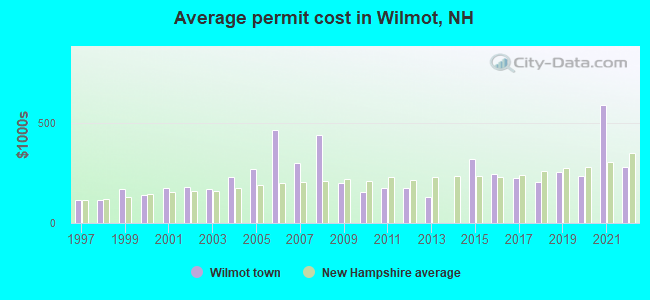
Single-family new house construction building permits:
- 2022: 15 buildings, average cost: $279,200
- 2021: 6 buildings, average cost: $591,300
- 2020: 4 buildings, average cost: $235,500
- 2019: 3 buildings, average cost: $252,700
- 2018: 1 building, cost: $205,000
- 2017: 2 buildings, average cost: $225,000
- 2016: 4 buildings, average cost: $246,000
- 2015: 4 buildings, average cost: $318,800
- 2013: 1 building, cost: $130,000
- 2012: 2 buildings, average cost: $175,000
- 2011: 4 buildings, average cost: $172,800
- 2010: 6 buildings, average cost: $154,200
- 2009: 1 building, cost: $200,000
- 2008: 7 buildings, average cost: $442,100
- 2007: 9 buildings, average cost: $301,900
- 2006: 11 buildings, average cost: $467,700
- 2005: 11 buildings, average cost: $269,100
- 2004: 11 buildings, average cost: $229,000
- 2003: 29 buildings, average cost: $170,000
- 2002: 21 buildings, average cost: $182,000
- 2001: 12 buildings, average cost: $176,700
- 2000: 9 buildings, average cost: $141,600
- 1999: 13 buildings, average cost: $171,200
- 1998: 4 buildings, average cost: $116,100
- 1997: 3 buildings, average cost: $116,100

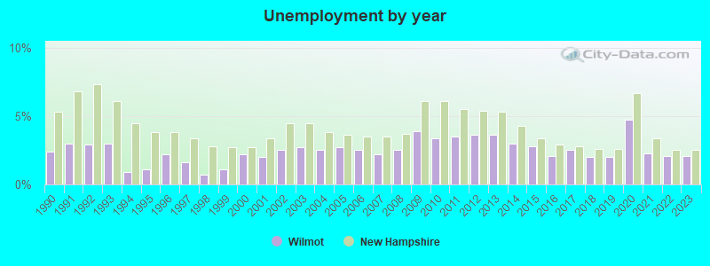
| Here: | 2.1% |
| New Hampshire: | 2.5% |

- Construction (15.1%)
- Educational services (13.8%)
- Health care (9.9%)
- Professional, scientific, technical services (9.1%)
- Finance & insurance (4.4%)
- Accommodation & food services (3.9%)
- Food & beverage stores (3.7%)
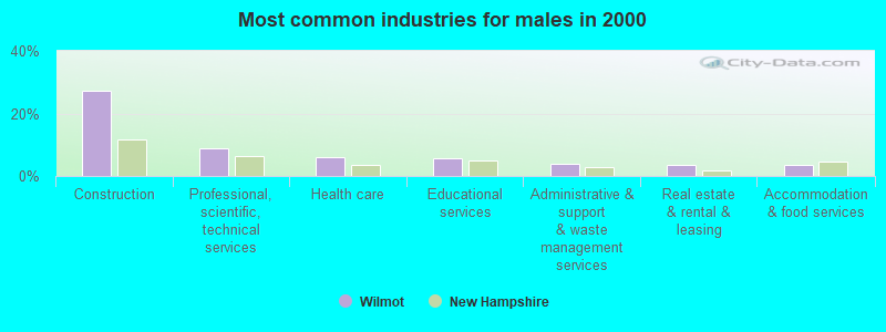
- Construction (27.3%)
- Professional, scientific, technical services (8.8%)
- Health care (6.2%)
- Educational services (5.8%)
- Administrative & support & waste management services (3.9%)
- Real estate & rental & leasing (3.6%)
- Accommodation & food services (3.6%)

- Educational services (22.3%)
- Health care (13.9%)
- Professional, scientific, technical services (9.4%)
- Food & beverage stores (7.0%)
- Finance & insurance (6.6%)
- Public administration (4.5%)
- Accommodation & food services (4.2%)
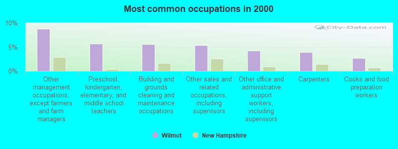
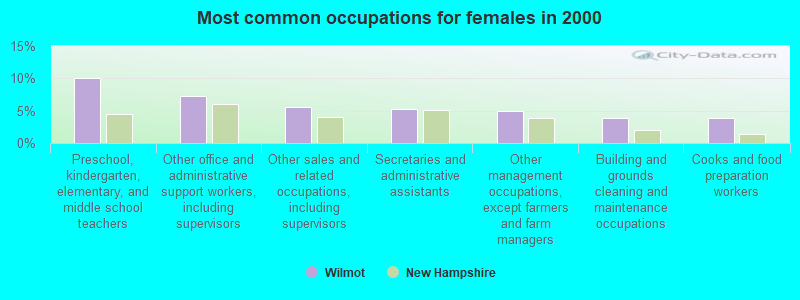
- Other management occupations, except farmers and farm managers (8.7%)
- Preschool, kindergarten, elementary, and middle school teachers (5.7%)
- Building and grounds cleaning and maintenance occupations (5.5%)
- Other sales and related occupations, including supervisors (5.4%)
- Other office and administrative support workers, including supervisors (4.2%)
- Carpenters (3.9%)
- Cooks and food preparation workers (2.7%)
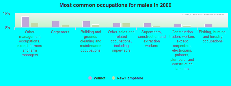
- Other management occupations, except farmers and farm managers (12.3%)
- Carpenters (7.5%)
- Building and grounds cleaning and maintenance occupations (7.1%)
- Other sales and related occupations, including supervisors (5.2%)
- Supervisors, construction and extraction workers (4.9%)
- Construction traders workers except carpenters, electricians, painters, plumbers, and construction laborers (3.9%)
- Fishing, hunting, and forestry occupations (3.6%)
- Preschool, kindergarten, elementary, and middle school teachers (10.1%)
- Other office and administrative support workers, including supervisors (7.3%)
- Other sales and related occupations, including supervisors (5.6%)
- Secretaries and administrative assistants (5.2%)
- Other management occupations, except farmers and farm managers (4.9%)
- Building and grounds cleaning and maintenance occupations (3.8%)
- Cooks and food preparation workers (3.8%)
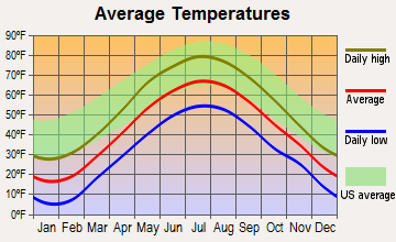
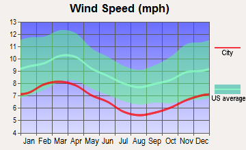
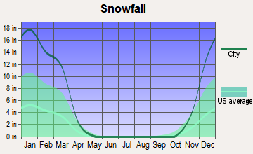
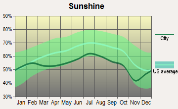
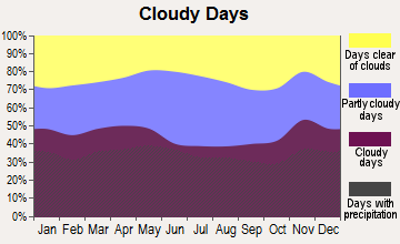
Average climate in Wilmot, New Hampshire
Based on data reported by over 4,000 weather stations
(lower is better)
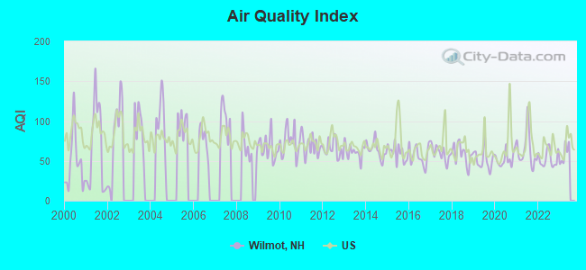
Air Quality Index (AQI) level in 2022 was 52.4. This is better than average.
| City: | 52.4 |
| U.S.: | 72.6 |
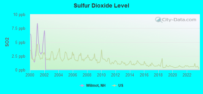
Sulfur Dioxide (SO2) [ppb] level in 2001 was 4.62. This is significantly worse than average. Closest monitor was 22.0 miles away from the city center.
| City: | 4.62 |
| U.S.: | 1.51 |
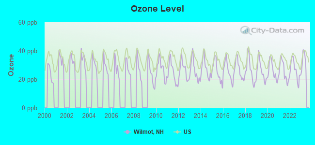
Ozone [ppb] level in 2022 was 26.3. This is better than average. Closest monitor was 22.0 miles away from the city center.
| City: | 26.3 |
| U.S.: | 33.3 |
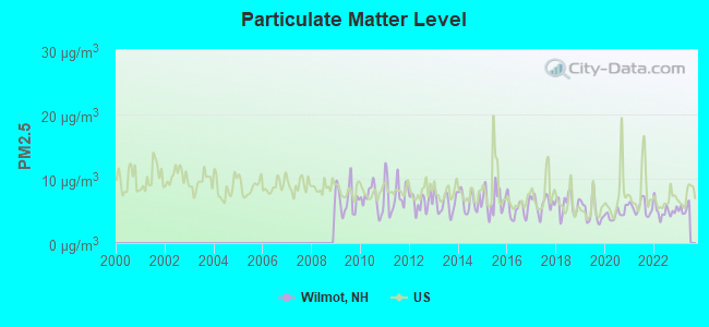
Particulate Matter (PM2.5) [µg/m3] level in 2022 was 5.02. This is significantly better than average. Closest monitor was 11.8 miles away from the city center.
| City: | 5.02 |
| U.S.: | 8.11 |
Tornado activity:
Wilmot-area historical tornado activity is near New Hampshire state average. It is 54% smaller than the overall U.S. average.
On 5/11/1973, a category F2 (max. wind speeds 113-157 mph) tornado 8.4 miles away from the Wilmot town center .
On 7/9/1962, a category F2 tornado 22.4 miles away from the town center caused between $500 and $5000 in damages.
Earthquake activity:
Wilmot-area historical earthquake activity is significantly above New Hampshire state average. It is 71% smaller than the overall U.S. average.On 4/20/2002 at 10:50:47, a magnitude 5.3 (5.3 ML, Depth: 3.0 mi, Class: Moderate, Intensity: VI - VII) earthquake occurred 115.1 miles away from Wilmot center
On 10/7/1983 at 10:18:46, a magnitude 5.3 (5.1 MB, 5.3 LG, 5.1 ML) earthquake occurred 126.2 miles away from the city center
On 4/20/2002 at 10:50:47, a magnitude 5.2 (5.2 MB, 4.2 MS, 5.2 MW, 5.0 MW) earthquake occurred 114.8 miles away from Wilmot center
On 1/19/1982 at 00:14:42, a magnitude 4.7 (4.5 MB, 4.7 MD, 4.5 LG, Class: Light, Intensity: IV - V) earthquake occurred 16.2 miles away from Wilmot center
On 10/16/2012 at 23:12:25, a magnitude 4.7 (4.7 ML, Depth: 10.0 mi) earthquake occurred 64.0 miles away from Wilmot center
On 6/16/1995 at 12:13:11, a magnitude 3.8 (3.8 LG, Depth: 3.1 mi, Class: Light, Intensity: II - III) earthquake occurred 57.8 miles away from Wilmot center
Magnitude types: regional Lg-wave magnitude (LG), body-wave magnitude (MB), duration magnitude (MD), local magnitude (ML), surface-wave magnitude (MS), moment magnitude (MW)
Natural disasters:
The number of natural disasters in Merrimack County (27) is a lot greater than the US average (15).Major Disasters (Presidential) Declared: 17
Emergencies Declared: 9
Causes of natural disasters: Storms: 13, Floods: 12, Winter Storms: 4, Snowstorms: 3, Hurricanes: 2, Snows: 2, Blizzard: 1, Ice Storm: 1, Snowfall: 1, Tornado: 1, Tropical Storm: 1, Wind: 1, Other: 1 (Note: some incidents may be assigned to more than one category).
Hospitals and medical centers near Wilmot:
- LAKE SUNAPEE REGION VNA (Home Health Center, about 5 miles away; NEW LONDON, NH)
- NEW LONDON HOSPITAL Critical Access Hospitals (about 6 miles away; NEW LONDON, NH)
- NEW LONDON HOSPITAL ASSOCIATION INC (Hospital, about 6 miles away; NEW LONDON, NH)
- WILLIAM CLOUGH ECU (Nursing Home, about 6 miles away; NEW LONDON, NH)
- MERRILL MANOR ANNEX (Nursing Home, about 14 miles away; FRANKLIN, NH)
- MERRILL MANOR NURSING HOME (Nursing Home, about 14 miles away; FRANKLIN, NH)
- NEWFOUND AREA NURSING ASSN (Home Health Center, about 14 miles away; BRISTOL, NH)
Colleges/universities with over 2000 students nearest to Wilmot:
- Plymouth State University (about 25 miles; Plymouth, NH; Full-time enrollment: 4,838)
- NHTI-Concord's Community College (about 25 miles; Concord, NH; FT enrollment: 2,865)
- Dartmouth College (about 26 miles; Hanover, NH; FT enrollment: 6,030)
- Southern New Hampshire University (about 37 miles; Manchester, NH; FT enrollment: 16,552)
- Saint Anselm College (about 39 miles; Manchester, NH; FT enrollment: 2,059)
- Mount Washington College (about 41 miles; Manchester, NH; FT enrollment: 2,187)
- Keene State College (about 41 miles; Keene, NH; FT enrollment: 5,098)
Points of interest:
Notable locations in Wilmot: Camp Wilmot (A), Wilmot Volunteer Fire and Rescue Company Incorporated (B). Display/hide their locations on the map
Churches in Wilmot include: Wilmot Flat Baptist Church (A), North Wilmot Congregational Church (B). Display/hide their locations on the map
Cemetery: Bunker Hill Cemetery (1). Display/hide its location on the map
Lakes and reservoirs: Butterfield Pond (A), Eagle Pond (B), Piper Pond (C), White Pond (D), Chase Pond (E), Tannery Pond (F). Display/hide their locations on the map
Streams, rivers, and creeks: Whitney Brook (A), Kimpton Brook (B), Cassey Brook (C). Display/hide their locations on the map
Hotel: The Inn at Ragged Edge Farm (318 New Canada Road) (1). Display/hide its approximate location on the map
Drinking water stations with addresses in Wilmot and their reported violations in the past:
WILMOT COMMUNITY CENTER (Population served: 25, Groundwater):Past monitoring violations:
- 2 routine major monitoring violations
| This town: | 2.4 people |
| New Hampshire: | 2.5 people |
| This town: | 69.0% |
| Whole state: | 66.3% |
| This town: | 8.7% |
| Whole state: | 8.3% |
Likely homosexual households (counted as self-reported same-sex unmarried-partner households)
- Lesbian couples: 0.5% of all households
- Gay men: 0.7% of all households
| This town: | 4.4% |
| Whole state: | 6.5% |
| This town: | 2.2% |
| Whole state: | 2.8% |
For population 15 years and over in Wilmot:
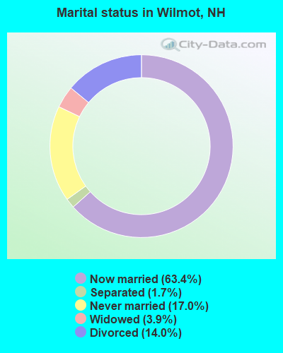
- Never married: 17.0%
- Now married: 63.4%
- Separated: 1.7%
- Widowed: 3.9%
- Divorced: 14.0%
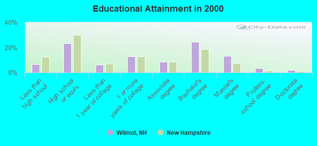
For population 25 years and over in Wilmot:
- High school or higher: 93.5%
- Bachelor's degree or higher: 42.6%
- Graduate or professional degree: 18.2%
- Unemployed: 2.9%
- Mean travel time to work (commute): 25.0 minutes
| Here: | 10.4 |
| New Hampshire average: | 10.9 |
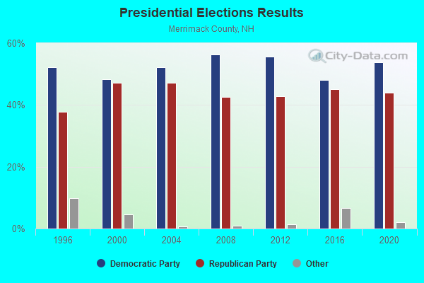
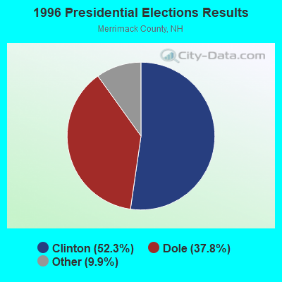
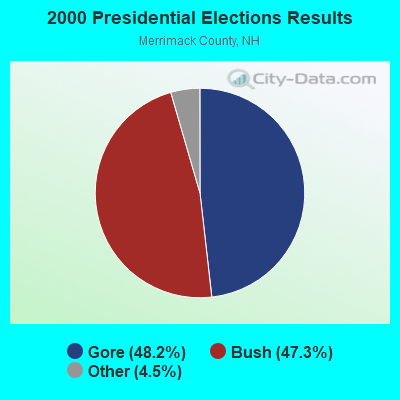
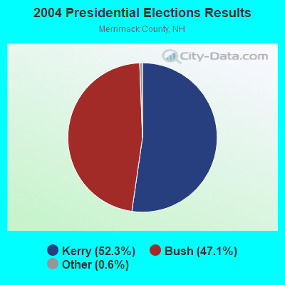

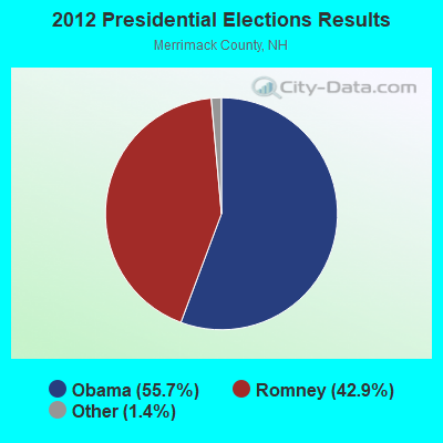
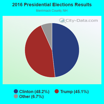
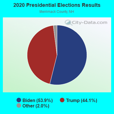
Graphs represent county-level data. Detailed 2008 Election Results
Religion statistics for Wilmot, NH (based on Merrimack County data)
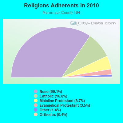
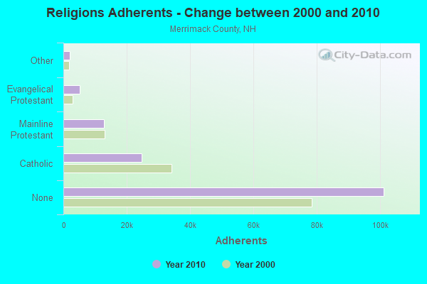
| Religion | Adherents | Congregations |
|---|---|---|
| Catholic | 24,654 | 7 |
| Mainline Protestant | 12,791 | 51 |
| Evangelical Protestant | 5,195 | 36 |
| Other | 2,097 | 15 |
| Orthodox | 580 | 2 |
| None | 101,128 | - |
Food Environment Statistics:
| Here: | 1.82 / 10,000 pop. |
| State: | 2.14 / 10,000 pop. |
| This county: | 0.14 / 10,000 pop. |
| New Hampshire: | 0.15 / 10,000 pop. |
| This county: | 1.22 / 10,000 pop. |
| New Hampshire: | 1.78 / 10,000 pop. |
| Here: | 4.39 / 10,000 pop. |
| New Hampshire: | 4.02 / 10,000 pop. |
| Merrimack County: | 7.77 / 10,000 pop. |
| New Hampshire: | 9.70 / 10,000 pop. |
| Merrimack County: | 7.4% |
| State: | 7.6% |
| Merrimack County: | 23.8% |
| State: | 24.4% |
| Merrimack County: | 16.9% |
| New Hampshire: | 15.9% |
Strongest AM radio stations in Wilmot:
- WNTK (1020 AM; 10 kW; NEWPORT, NH; Owner: KOOR COMMUNICATIONS, INC.)
- WRKO (680 AM; 50 kW; BOSTON, MA; Owner: ENTERCOM BOSTON LICENSE, LLC)
- WEZS (1350 AM; 5 kW; LACONIA, NH; Owner: GARY W. HAMMOND)
- WCRN (830 AM; 50 kW; WORCESTER, MA; Owner: CARTER BROADCASTING CORPORATION)
- WNNZ (640 AM; 50 kW; WESTFIELD, MA; Owner: CLEAR CHANNEL BROADCASTING LICENSES, INC.)
- WEEI (850 AM; 50 kW; BOSTON, MA; Owner: ENTERCOM BOSTON LICENSE, LLC)
- WPNH (1300 AM; 5 kW; PLYMOUTH, NH; Owner: NORTHEAST COMMUNICATIONS CORPORATION)
- WKOX (1200 AM; 50 kW; FRAMINGHAM, MA; Owner: CAPSTAR TX LIMITED PARTNERSHIP)
- WGIR (610 AM; 5 kW; MANCHESTER, NH; Owner: CAPSTAR TX LIMITED PARTNERSHIP)
- WBIX (1060 AM; 40 kW; NATICK, MA; Owner: LANGER BROADCASTING CORPORATION)
- WBZ (1030 AM; 50 kW; BOSTON, MA; Owner: INFINITY BROADCASTING OPERATIONS, INC.)
- WWZN (1510 AM; 50 kW; BOSTON, MA; Owner: ROSE CITY RADIO CORPORATION)
- WALE (990 AM; 50 kW; GREENVILLE, RI; Owner: NORTH AMERICAN BROADCASTING CO., INC.)
Strongest FM radio stations in Wilmot:
- WNTK-FM (99.7 FM; NEW LONDON, NH; Owner: SHEILA E. VINIKOOR)
- WSCS (90.9 FM; NEW LONDON, NH; Owner: COLBY-SAWYER COLLEGE)
- WHDQ (106.1 FM; CLAREMONT, NH; Owner: GREAT NORTHERN RADIO, L.L.C.)
- WVPR (89.5 FM; WINDSOR, VT; Owner: VERMONT PUBLIC RADIO)
- WPNH-FM (100.1 FM; PLYMOUTH, NH; Owner: NORTHEAST COMMUNICATIONS CORPORATION)
- WVRR (101.7 FM; NEWPORT, NH; Owner: CAPSTAR TX LIMITED PARTNERSHIP)
- WEVH (91.3 FM; HANOVER, NH; Owner: NEW HAMPSHIRE PUBLIC RADIO INC)
- WNHI (93.3 FM; BELMONT, NH; Owner: CONCORD BROADCASTING, L.L.C.)
- WSCY (106.9 FM; MOULTONBOROUGH, NH; Owner: NORTHEAST COMMUNICATIONS CORPORATION)
- WJJR (98.1 FM; RUTLAND, VT; Owner: 6 JOHNSON ROAD LICENSES, INC.)
- WZRT (97.1 FM; RUTLAND, VT; Owner: CAPSTAR TX LIMITED PARTNERSHIP)
- WPKQ (103.7 FM; NORTH CONWAY, NH; Owner: CITADEL BROADCASTING COMPANY)
- WVFM (105.7 FM; CAMPTON, NH; Owner: DEVON BROADCASTING COMPANY, INC.)
- WEBK (105.3 FM; KILLINGTON, VT; Owner: 6 JOHNSON ROAD LICENSES, INC.)
- WHOM (94.9 FM; MT. WASHINGTON, NH; Owner: CITADEL BROADCASTING COMPANY)
- WNNH (99.1 FM; HENNIKER, NH; Owner: TELE-MEDIA COMPANY OF NEW HAMPSHIRE, L.L.C.)
- WGLV (91.7 FM; WOODSTOCK, VT; Owner: CHRISTIAN MINISTRIES INC)
- WHDQ-FM1 (106.1 FM; RUTLAND, VT; Owner: GREAT NORTHERN RADIO, L.L.C.)
- WLKZ (104.9 FM; WOLFEBORO, NH; Owner: TELE-MEDIA COMPANY OF NEW HAMPSHIRE, L.L.C.)
- WFTN-FM (94.1 FM; FRANKLIN, NH; Owner: NORTHEAST COMMUNICATIONS CORPORATION)
TV broadcast stations around Wilmot:
- WMEA-TV (Channel 26; BIDDEFORD, ME; Owner: MAINE PUBLIC BROADCASTING CORP.)
- W15BK (Channel 15; HANOVER, NH; Owner: UNIVERSITY OF NEW HAMPSHIRE)
- WVTA (Channel 41; WINDSOR, VT; Owner: VERMONT ETV, INC.)
- National Bridge Inventory (NBI) Statistics
- 14Number of bridges
- 49ft / 15.0mTotal length
- $43,988,000Total costs
- 7,716Total average daily traffic
- 428Total average daily truck traffic
- 11,410Total future (year 2042) average daily traffic

- New bridges - historical statistics
- 11910-1919
- 11930-1939
- 11940-1949
- 11950-1959
- 31960-1969
- 11970-1979
- 21980-1989
- 21990-1999
- 22000-2009
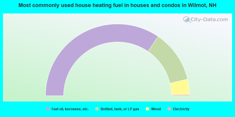
- 69.1%Fuel oil, kerosene, etc.
- 23.5%Bottled, tank, or LP gas
- 6.9%Wood
- 0.5%Electricity
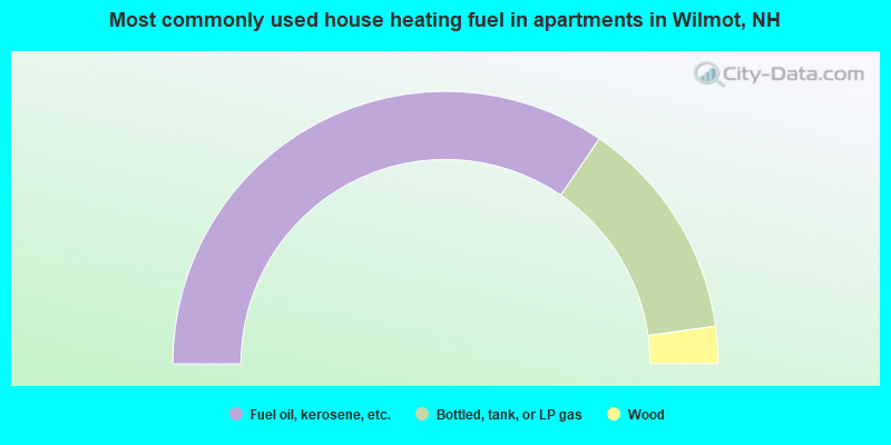
- 69.1%Fuel oil, kerosene, etc.
- 26.5%Bottled, tank, or LP gas
- 4.4%Wood
Wilmot compared to New Hampshire state average:
- Unemployed percentage significantly below state average.
- Black race population percentage significantly below state average.
- Hispanic race population percentage significantly below state average.
- Foreign-born population percentage below state average.
- Renting percentage below state average.
- Length of stay since moving in significantly above state average.
- Number of rooms per house significantly below state average.
- House age significantly below state average.

|
|
Total of 39 patent applications in 2008-2024.