Woodstock, New Hampshire
Submit your own pictures of this town and show them to the world
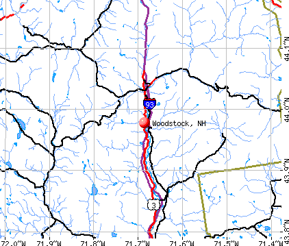
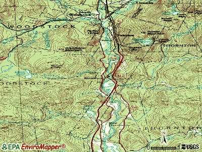
- OSM Map
- General Map
- Google Map
- MSN Map
Population change since 2000: +20.6%
| Males: 694 | |
| Females: 680 |
| Median resident age: | 44.2 years |
| New Hampshire median age: | 43.9 years |
Zip codes: 03223.
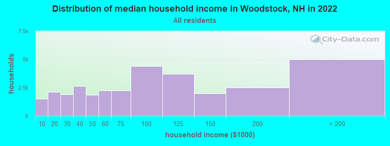
| Woodstock: | $69,520 |
| NH: | $89,992 |
Estimated per capita income in 2022: $45,418 (it was $19,973 in 2000)
Woodstock town income, earnings, and wages data
Estimated median house or condo value in 2022: $297,888 (it was $93,200 in 2000)
| Woodstock: | $297,888 |
| NH: | $384,700 |
Mean prices in 2022: all housing units: $486,096; detached houses: $533,852; townhouses or other attached units: $375,744; in 2-unit structures: $230,260; in 3-to-4-unit structures: $242,363; in 5-or-more-unit structures: $588,257; mobile homes: $127,035
Detailed information about poverty and poor residents in Woodstock, NH
Compare current foreclosures near Woodstock, NH:
| Photo | Address | Area | Beds / Baths | Price | Details |
|---|---|---|---|---|---|

|
#1
Daniel Webster Hwy
North Woodstock, NH 03262
|
1,040 sq. feet
|
1 baths 2 beds |
show details | |

|
#2
Summit Dr
Campton, NH 03223
|
- sq. feet
|
- baths - beds |
show details | |

|
#3
Livermore Rd
Campton, NH 03223
|
- sq. feet
|
- baths - beds |
show details | |

|
#4
Fairgrounds Rd
Plymouth, NH 03264
|
- sq. feet
|
- baths - beds |
show details | |

|
Check over 1 million property listings on Foreclosure.com!
|
browse all offers | |||

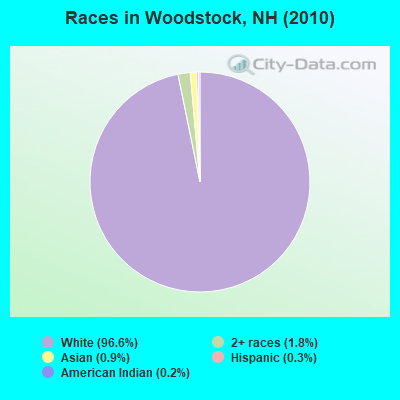
- 1,32796.6%White alone
- 251.8%Two or more races
- 120.9%Asian alone
- 40.3%Hispanic
- 30.2%American Indian alone
- 10.07%Black alone
- 10.07%Native Hawaiian and Other
Pacific Islander alone - 10.07%Other race alone
Races in Woodstock detailed stats: ancestries, foreign born residents, place of birth
According to our research of New Hampshire and other state lists, there was 1 registered sex offender living in Woodstock, New Hampshire as of April 19, 2024.
The ratio of all residents to sex offenders in Woodstock is 1,374 to 1.
The ratio of registered sex offenders to all residents in this city is much lower than the state average.
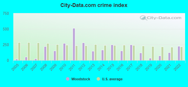
Type |
2009 |
2010 |
2011 |
2012 |
2013 |
2014 |
2015 |
2016 |
2017 |
2018 |
2019 |
2020 |
2021 |
2022 |
|---|---|---|---|---|---|---|---|---|---|---|---|---|---|---|
| Murders (per 100,000) | 0 (0.0) | 0 (0.0) | 1 (72.7) | 0 (0.0) | 0 (0.0) | 0 (0.0) | 0 (0.0) | 0 (0.0) | 0 (0.0) | 0 (0.0) | 0 (0.0) | 0 (0.0) | 0 (0.0) | 0 (0.0) |
| Rapes (per 100,000) | 1 (85.6) | 2 (145.6) | 3 (218.0) | 0 (0.0) | 0 (0.0) | 0 (0.0) | 2 (144.0) | 0 (0.0) | 2 (146.3) | 1 (73.4) | 0 (0.0) | 0 (0.0) | 1 (72.8) | 2 (137.6) |
| Robberies (per 100,000) | 0 (0.0) | 1 (72.8) | 0 (0.0) | 1 (72.8) | 0 (0.0) | 0 (0.0) | 0 (0.0) | 1 (72.8) | 0 (0.0) | 0 (0.0) | 0 (0.0) | 0 (0.0) | 0 (0.0) | 0 (0.0) |
| Assaults (per 100,000) | 0 (0.0) | 3 (218.3) | 4 (290.7) | 4 (291.1) | 1 (73.9) | 4 (288.2) | 0 (0.0) | 0 (0.0) | 1 (73.2) | 1 (73.4) | 0 (0.0) | 0 (0.0) | 0 (0.0) | 1 (68.8) |
| Burglaries (per 100,000) | 4 (342.5) | 4 (291.1) | 7 (508.7) | 12 (873.4) | 4 (295.4) | 6 (432.3) | 8 (576.0) | 10 (727.8) | 8 (585.2) | 4 (293.7) | 4 (292.2) | 4 (293.3) | 2 (145.7) | 8 (550.2) |
| Thefts (per 100,000) | 14 (1,199) | 25 (1,820) | 33 (2,398) | 45 (3,275) | 32 (2,363) | 25 (1,801) | 26 (1,872) | 24 (1,747) | 24 (1,756) | 7 (514.0) | 4 (292.2) | 16 (1,173) | 19 (1,384) | 19 (1,307) |
| Auto thefts (per 100,000) | 2 (171.2) | 0 (0.0) | 1 (72.7) | 2 (145.6) | 3 (221.6) | 1 (72.0) | 3 (216.0) | 2 (145.6) | 1 (73.2) | 1 (73.4) | 1 (73.0) | 1 (73.3) | 0 (0.0) | 2 (137.6) |
| Arson (per 100,000) | 0 (0.0) | 1 (72.8) | 0 (0.0) | 0 (0.0) | 3 (221.6) | 0 (0.0) | 0 (0.0) | 0 (0.0) | 0 (0.0) | 0 (0.0) | 1 (73.0) | 0 (0.0) | 0 (0.0) | 0 (0.0) |
| City-Data.com crime index | 154.1 | 275.1 | 515.3 | 283.8 | 147.7 | 165.7 | 247.7 | 154.3 | 248.7 | 120.4 | 38.0 | 73.3 | 123.8 | 225.6 |
The City-Data.com crime index weighs serious crimes and violent crimes more heavily. Higher means more crime, U.S. average is 246.1. It adjusts for the number of visitors and daily workers commuting into cities.
Crime rate in Woodstock detailed stats: murders, rapes, robberies, assaults, burglaries, thefts, arson
Full-time law enforcement employees in 2021, including police officers: 3 (3 officers - 2 male; 1 female).
| Officers per 1,000 residents here: | 2.18 |
| New Hampshire average: | 2.14 |
 Recent articles from our blog. Our writers, many of them Ph.D. graduates or candidates, create easy-to-read articles on a wide variety of topics.


 | Driving through New Hampshire (6 replies) |
| Weekend Getaway In February (3 replies) |
| Upper Valley neighborhood for young families? (Lyme, Norwich, Lebanon, Woodstock?) (1 reply) |
| Auto mechanic-Lincoln/Woodstock/Plymouth (6 replies) |
| Tiny house living possible in NH? (18 replies) |
| Woodstock in pulled pork review (3 replies) |
Latest news from Woodstock, NH collected exclusively by city-data.com from local newspapers, TV, and radio stations
Ancestries: French (20.5%), Irish (19.7%), English (19.1%), Scottish (9.8%), German (9.0%), United States (8.8%).
Current Local Time: EST time zone
Incorporated in 1763
Elevation: 701 feet
Land area: 58.7 square miles.
Population density: 23 people per square mile (very low).
31 residents are foreign born (1.0% Asia, 0.6% Europe, 0.6% North America, 0.4% Latin America).
| This town: | 2.7% |
| New Hampshire: | 4.4% |
| Woodstock town: | 1.8% ($1,683) |
| New Hampshire: | 2.3% ($2,946) |
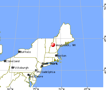
Nearest city with pop. 50,000+: Manchester, NH  (71.5 miles , pop. 107,006).
Nearest city with pop. 200,000+: Boston, MA (120.3 miles , pop. 589,141).
Nearest city with pop. 1,000,000+: Bronx, NY (245.4 miles , pop. 1,332,650).
Nearest cities:
), Latitude: 44.01 N, Longitude: 71.69 W
Area code commonly used in this area: 603

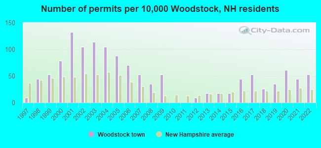
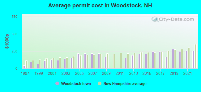
Single-family new house construction building permits:
- 2022: 6 buildings, average cost: $257,400
- 2021: 5 buildings, average cost: $259,200
- 2020: 7 buildings, average cost: $248,200
- 2019: 4 buildings, average cost: $282,200
- 2018: 3 buildings, average cost: $163,600
- 2017: 6 buildings, average cost: $246,000
- 2016: 5 buildings, average cost: $246,000
- 2015: 2 buildings, average cost: $211,200
- 2014: 2 buildings, average cost: $211,200
- 2013: 2 buildings, average cost: $190,000
- 2012: 1 building, cost: $153,700
- 2009: 6 buildings, average cost: $165,800
- 2008: 4 buildings, average cost: $217,700
- 2007: 6 buildings, average cost: $217,700
- 2006: 8 buildings, average cost: $217,700
- 2005: 10 buildings, average cost: $217,700
- 2004: 12 buildings, average cost: $153,000
- 2003: 13 buildings, average cost: $141,400
- 2002: 12 buildings, average cost: $118,900
- 2001: 15 buildings, average cost: $128,900
- 2000: 9 buildings, average cost: $116,000
- 1999: 6 buildings, average cost: $65,800
- 1998: 5 buildings, average cost: $94,400
- 1997: 1 building, cost: $44,200
| Here: | 1.8% |
| New Hampshire: | 2.5% |
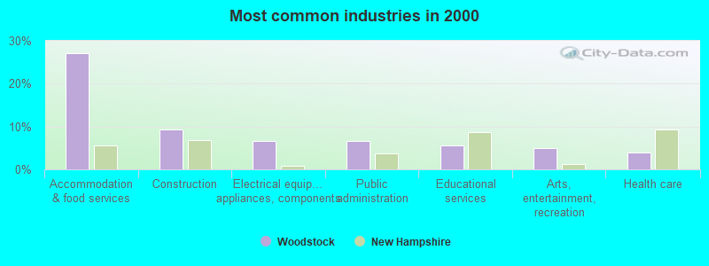
- Accommodation & food services (27.0%)
- Construction (9.3%)
- Electrical equipment, appliances, components (6.7%)
- Public administration (6.6%)
- Educational services (5.5%)
- Arts, entertainment, recreation (4.9%)
- Health care (4.0%)
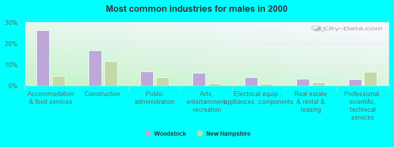
- Accommodation & food services (26.3%)
- Construction (16.8%)
- Public administration (6.7%)
- Arts, entertainment, recreation (6.2%)
- Electrical equipment, appliances, components (3.9%)
- Real estate & rental & leasing (3.4%)
- Professional, scientific, technical services (3.1%)
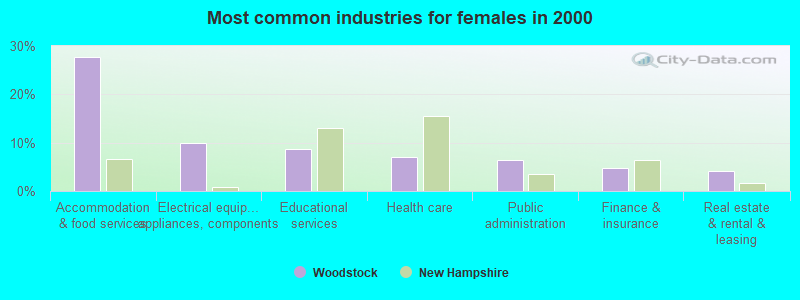
- Accommodation & food services (27.8%)
- Electrical equipment, appliances, components (9.9%)
- Educational services (8.6%)
- Health care (7.0%)
- Public administration (6.4%)
- Finance & insurance (4.8%)
- Real estate & rental & leasing (4.2%)
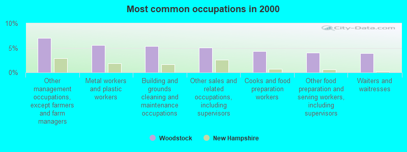
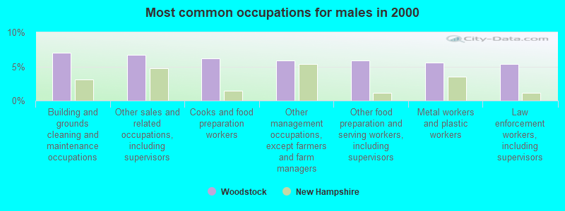
- Other management occupations, except farmers and farm managers (7.0%)
- Metal workers and plastic workers (5.5%)
- Building and grounds cleaning and maintenance occupations (5.4%)
- Other sales and related occupations, including supervisors (5.1%)
- Cooks and food preparation workers (4.3%)
- Other food preparation and serving workers, including supervisors (4.0%)
- Waiters and waitresses (3.9%)
- Building and grounds cleaning and maintenance occupations (7.0%)
- Other sales and related occupations, including supervisors (6.7%)
- Cooks and food preparation workers (6.2%)
- Other management occupations, except farmers and farm managers (5.9%)
- Other food preparation and serving workers, including supervisors (5.9%)
- Metal workers and plastic workers (5.6%)
- Law enforcement workers, including supervisors (5.3%)
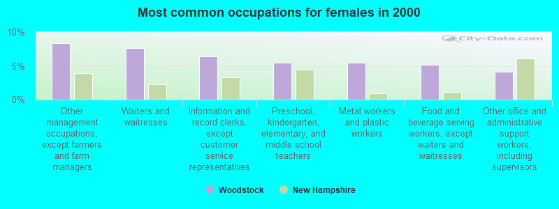
- Other management occupations, except farmers and farm managers (8.3%)
- Waiters and waitresses (7.7%)
- Information and record clerks, except customer service representatives (6.4%)
- Preschool, kindergarten, elementary, and middle school teachers (5.4%)
- Metal workers and plastic workers (5.4%)
- Food and beverage serving workers, except waiters and waitresses (5.1%)
- Other office and administrative support workers, including supervisors (4.2%)
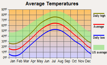
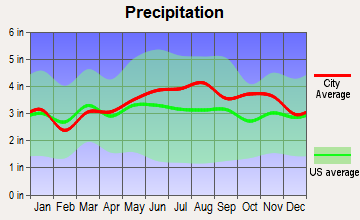
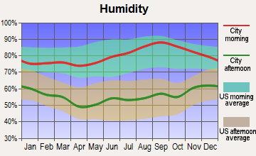
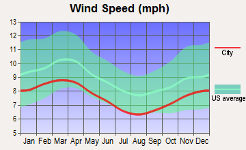
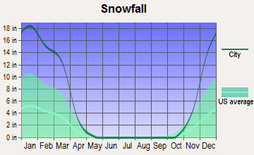
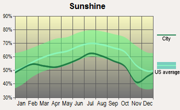
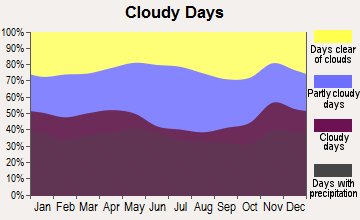
Average climate in Woodstock, New Hampshire
Based on data reported by over 4,000 weather stations
(lower is better)
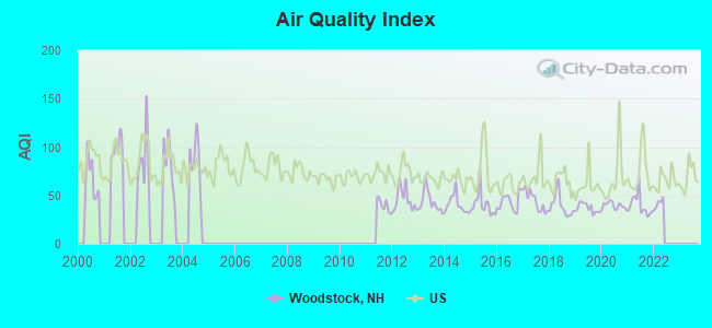
Air Quality Index (AQI) level in 2021 was 39.8. This is significantly better than average.
| City: | 39.8 |
| U.S.: | 72.6 |
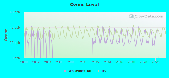
Ozone [ppb] level in 2021 was 25.7. This is better than average. Closest monitor was 4.3 miles away from the city center.
| City: | 25.7 |
| U.S.: | 33.3 |
Tornado activity:
Woodstock-area historical tornado activity is below New Hampshire state average. It is 76% smaller than the overall U.S. average.
On 8/11/1966, a category F2 (max. wind speeds 113-157 mph) tornado 12.9 miles away from the Woodstock town center caused between $50,000 and $500,000 in damages.
On 5/11/1973, a category F2 tornado 32.9 miles away from the town center .
Earthquake activity:
Woodstock-area historical earthquake activity is significantly above New Hampshire state average. It is 72% smaller than the overall U.S. average.On 4/20/2002 at 10:50:47, a magnitude 5.3 (5.3 ML, Depth: 3.0 mi, Class: Moderate, Intensity: VI - VII) earthquake occurred 105.6 miles away from the city center
On 4/20/2002 at 10:50:47, a magnitude 5.2 (5.2 MB, 4.2 MS, 5.2 MW, 5.0 MW) earthquake occurred 106.0 miles away from the city center
On 10/7/1983 at 10:18:46, a magnitude 5.3 (5.1 MB, 5.3 LG, 5.1 ML) earthquake occurred 132.2 miles away from Woodstock center
On 1/19/1982 at 00:14:42, a magnitude 4.7 (4.5 MB, 4.7 MD, 4.5 LG, Class: Light, Intensity: IV - V) earthquake occurred 35.3 miles away from the city center
On 10/16/2012 at 23:12:25, a magnitude 4.7 (4.7 ML, Depth: 10.0 mi) earthquake occurred 58.7 miles away from the city center
On 8/21/1996 at 07:54:14, a magnitude 3.8 (3.8 LG, 3.6 LG, Depth: 6.2 mi, Class: Light, Intensity: II - III) earthquake occurred 20.7 miles away from Woodstock center
Magnitude types: regional Lg-wave magnitude (LG), body-wave magnitude (MB), duration magnitude (MD), local magnitude (ML), surface-wave magnitude (MS), moment magnitude (MW)
Natural disasters:
The number of natural disasters in Grafton County (32) is a lot greater than the US average (15).Major Disasters (Presidential) Declared: 20
Emergencies Declared: 9
Causes of natural disasters: Floods: 16, Storms: 16, Hurricanes: 3, Snows: 3, Winter Storms: 3, Tropical Storms: 2, Blizzard: 1, Heavy Rain: 1, Ice Storm: 1, Landslide: 1, Snowfall: 1, Snowstorm: 1, Wind: 1, Other: 1 (Note: some incidents may be assigned to more than one category).
Airports located in Woodstock:
- Bradley Field Airport (NH49) (Runways: 1)
Colleges/universities with over 2000 students nearest to Woodstock:
- Plymouth State University (about 18 miles; Plymouth, NH; Full-time enrollment: 4,838)
- Dartmouth College (about 37 miles; Hanover, NH; FT enrollment: 6,030)
- Norwich University (about 50 miles; Northfield, VT; FT enrollment: 4,221)
- NHTI-Concord's Community College (about 55 miles; Concord, NH; FT enrollment: 2,865)
- Saint Joseph's College of Maine (about 62 miles; Standish, ME; FT enrollment: 2,010)
- Southern New Hampshire University (about 68 miles; Manchester, NH; FT enrollment: 16,552)
- University of New Hampshire-Main Campus (about 72 miles; Durham, NH; FT enrollment: 15,243)
Points of interest:
Notable locations in Woodstock: Lost River Valley Campground (A), KOA Campground (B), Ravine Lodge (C), Jackman Brook Overlook (D), Beaver Brook Shelter DOC (E), McKenney Cabin (F), Woodstock Fire Department Station 2 Lower Station (G), Woodstock Fire Department Station 1 (H), Linwood Ambulance Service (I). Display/hide their locations on the map
Churches in Woodstock include: Church of the Messiah Episcopal Church (A), Pemi Valley Church (B). Display/hide their locations on the map
Lakes and reservoirs: Russell Pond (A), Elbow Pond (B), Beaver Pond (C), North Woodstock Reservoir (D). Display/hide their locations on the map
Streams, rivers, and creeks: Jackman Brook (A), Horner Brook (B), Gorge Brook (C), Gordon Pond Brook (D), Glover Brook (E), Eastman Brook (F), East Branch Pemigewasset River (G), Crooked Brook (H), Russell Pond Brook (I). Display/hide their locations on the map
Parks in Woodstock include: White Mountain Motorsports Park (1), Russell Pond Recreation Area (2), Kinsman Notch Nature Area (3). Display/hide their locations on the map
Hotels: Meadowlark Motor Court (Daniel Webster Highw) (1), Six B Motel (Daniel Webster Hghwy) (2), Autumn Breeze Motor Lodge (Main North) (3). Display/hide their approximate locations on the map
Drinking water stations with addresses in Woodstock that have no violations reported:
- WATEREST CAMPGROUND (Population served: 90, Primary Water Source Type: Groundwater)
| This town: | 2.2 people |
| New Hampshire: | 2.5 people |
| This town: | 56.6% |
| Whole state: | 66.3% |
| This town: | 11.5% |
| Whole state: | 8.3% |
Likely homosexual households (counted as self-reported same-sex unmarried-partner households)
- Lesbian couples: 0.5% of all households
- Gay men: 0.3% of all households
| This town: | 9.6% |
| Whole state: | 6.5% |
| This town: | 3.2% |
| Whole state: | 2.8% |
For population 15 years and over in Woodstock:
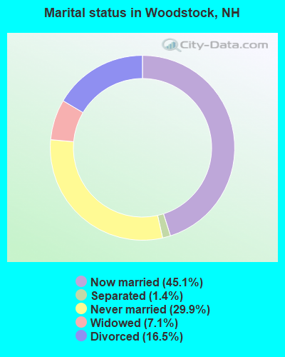
- Never married: 29.9%
- Now married: 45.1%
- Separated: 1.4%
- Widowed: 7.1%
- Divorced: 16.5%
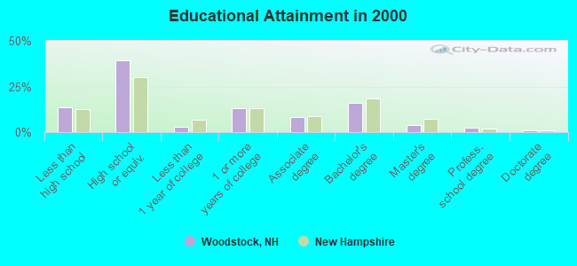
For population 25 years and over in Woodstock:
- High school or higher: 86.4%
- Bachelor's degree or higher: 23.0%
- Graduate or professional degree: 7.1%
- Unemployed: 4.1%
- Mean travel time to work (commute): 15.1 minutes
| Here: | 10.1 |
| New Hampshire average: | 10.9 |


Graphs represent county-level data. Detailed 2008 Election Results
Religion statistics for Woodstock, NH (based on Grafton County data)


| Religion | Adherents | Congregations |
|---|---|---|
| Catholic | 9,503 | 12 |
| Mainline Protestant | 7,832 | 57 |
| Evangelical Protestant | 1,494 | 29 |
| Other | 1,320 | 11 |
| None | 68,969 | - |
Food Environment Statistics:
| This county: | 3.87 / 10,000 pop. |
| New Hampshire: | 2.14 / 10,000 pop. |
| Grafton County: | 0.23 / 10,000 pop. |
| New Hampshire: | 0.15 / 10,000 pop. |
| Grafton County: | 1.29 / 10,000 pop. |
| New Hampshire: | 1.78 / 10,000 pop. |
| This county: | 6.45 / 10,000 pop. |
| New Hampshire: | 4.02 / 10,000 pop. |
| Grafton County: | 14.41 / 10,000 pop. |
| State: | 9.70 / 10,000 pop. |
| Here: | 7.2% |
| New Hampshire: | 7.6% |
| This county: | 22.9% |
| State: | 24.4% |
| This county: | 15.9% |
| New Hampshire: | 15.9% |
Businesses in Woodstock, NH
- U-Haul: 1
Strongest AM radio stations in Woodstock:
- WPNH (1300 AM; 5 kW; PLYMOUTH, NH; Owner: NORTHEAST COMMUNICATIONS CORPORATION)
- WTWN (1100 AM; daytime; 5 kW; WELLS RIVER, VT; Owner: PUFFER BROADCASTING, INC.)
- WRKO (680 AM; 50 kW; BOSTON, MA; Owner: ENTERCOM BOSTON LICENSE, LLC)
- WCRN (830 AM; 50 kW; WORCESTER, MA; Owner: CARTER BROADCASTING CORPORATION)
- WNNZ (640 AM; 50 kW; WESTFIELD, MA; Owner: CLEAR CHANNEL BROADCASTING LICENSES, INC.)
- WEEI (850 AM; 50 kW; BOSTON, MA; Owner: ENTERCOM BOSTON LICENSE, LLC)
- WCHP (760 AM; 35 kW; CHAMPLAIN, NY; Owner: CHAMPLAIN RADIO, INC.)
- WNTK (1020 AM; 10 kW; NEWPORT, NH; Owner: KOOR COMMUNICATIONS, INC.)
- WBZ (1030 AM; 50 kW; BOSTON, MA; Owner: INFINITY BROADCASTING OPERATIONS, INC.)
- WEZS (1350 AM; 5 kW; LACONIA, NH; Owner: GARY W. HAMMOND)
- WKOX (1200 AM; 50 kW; FRAMINGHAM, MA; Owner: CAPSTAR TX LIMITED PARTNERSHIP)
- WGY (810 AM; 50 kW; SCHENECTADY, NY; Owner: CLEAR CHANNEL BROADCASTING LICENSES, INC.)
- WGIN (930 AM; 10 kW; ROCHESTER, NH; Owner: CAPSTAR TX LIMITED PARTNERSHIP)
Strongest FM radio stations in Woodstock:
- WVFM (105.7 FM; CAMPTON, NH; Owner: DEVON BROADCASTING COMPANY, INC.)
- WPKQ (103.7 FM; NORTH CONWAY, NH; Owner: CITADEL BROADCASTING COMPANY)
- WHOM (94.9 FM; MT. WASHINGTON, NH; Owner: CITADEL BROADCASTING COMPANY)
- WSCY (106.9 FM; MOULTONBOROUGH, NH; Owner: NORTHEAST COMMUNICATIONS CORPORATION)
- WPNH-FM (100.1 FM; PLYMOUTH, NH; Owner: NORTHEAST COMMUNICATIONS CORPORATION)
- WMTK (106.3 FM; LITTLETON, NH; Owner: VERMONT BROADCAST ASSOCIATES, INC.)
- WGMT (97.7 FM; LYNDON, VT; Owner: VERMONT BROADCAST ASSOCIATES, INC.)
- WLTN-FM (96.7 FM; LISBON, NH; Owner: PROFILE BROADCASTING CO., INC.)
- WEVH (91.3 FM; HANOVER, NH; Owner: NEW HAMPSHIRE PUBLIC RADIO INC)
- WXXS (102.3 FM; LANCASTER, NH; Owner: BARRY P. LUNDERVILLE)
- WHDQ (106.1 FM; CLAREMONT, NH; Owner: GREAT NORTHERN RADIO, L.L.C.)
- WCVT (101.7 FM; STOWE, VT; Owner: RADIO VERMONT CLASSICS, L.L.C.)
- WMEA (90.1 FM; PORTLAND, ME; Owner: MAINE PUBLIC BROADCASTING CORPORATION)
- WVPR (89.5 FM; WINDSOR, VT; Owner: VERMONT PUBLIC RADIO)
- WEBK (105.3 FM; KILLINGTON, VT; Owner: 6 JOHNSON ROAD LICENSES, INC.)
- WJJR (98.1 FM; RUTLAND, VT; Owner: 6 JOHNSON ROAD LICENSES, INC.)
- WZRT (97.1 FM; RUTLAND, VT; Owner: CAPSTAR TX LIMITED PARTNERSHIP)
- WVPS (107.9 FM; BURLINGTON, VT; Owner: VERMONT PUBLIC RADIO)
- WLKC (103.3 FM; WATERBURY, VT; Owner: RADIO BROADCASTING SERVICES, INC.)
- WEZF (92.9 FM; BURLINGTON, VT; Owner: CAPSTAR TX LIMITED PARTNERSHIP)
TV broadcast stations around Woodstock:
- WMTW-TV (Channel 8; POLAND SPRING, ME; Owner: WMTW BROADCAST GROUP, LLC)
- WCSH (Channel 6; PORTLAND, ME; Owner: PACIFIC AND SOUTHERN COMPANY, INC.)
- WLED-TV (Channel 49; LITTLETON, NH; Owner: UNIVERSITY OF NEW HAMPSHIRE)
- WMUR-LP (Channel 29; LITTLETON, NH; Owner: HEARST-ARGYLE PROPERTIES, INC.)
- W38CB (Channel 38; LITTLETON, NH; Owner: HEARST-ARGYLE PROPERTIES, INC.)
- Woodstock, New Hampshire
- Fatal accident count11
- Vehicles involved in fatal accidents11
- Fatal accidents involving drunk persons:4
- Fatalities11
- Persons involved in fatal accidents15
- Pedestrians involved in fatal accidents0
- New Hampshire average
- Fatal accident count1164
- Vehicles involved in fatal accidents1641
- Fatal accidents involving drunk persons486
- Fatalities1266
- Persons involved in fatal accidents2599
- Pedestrians involved in fatal accidents70
- National Bridge Inventory (NBI) Statistics
- 33Number of bridges
- 417ft / 127mTotal length
- $84,834,000Total costs
- 122,486Total average daily traffic
- 11,605Total average daily truck traffic
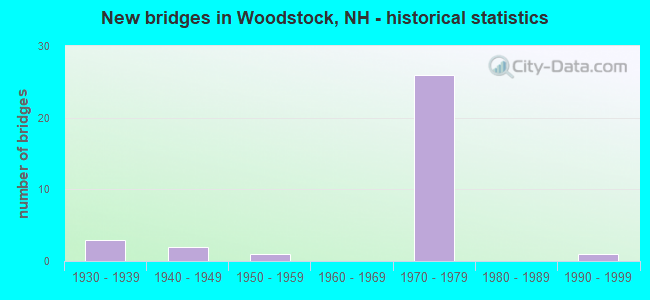
- New bridges - historical statistics
- 31930-1939
- 21940-1949
- 11950-1959
- 261970-1979
- 11990-1999
FCC Registered Cell Phone Towers:
1 (See the full list of FCC Registered Cell Phone Towers in Woodstock)FCC Registered Antenna Towers:
7 (See the full list of FCC Registered Antenna Towers)FCC Registered Broadcast Land Mobile Towers:
1- Woodstock Police Dept (Lat: 44.030056 Lon: -71.686750), Call Sign: KSX398,
Assigned Frequencies: 155.475 MHz, 155.910 MHz, 156.090 MHz, Grant Date: 11/19/2022, Expiration Date: 12/10/2032, Registrant: Nh Dept. Of Safety/Emergency Services And Communications, 33 Hazen Dr (Mailing), Concord, NH 03305, Phone: (603) 528-7541, Fax: (603) 271-6629, Email:
FCC Registered Microwave Towers:
2- LINCOLN, 1 Mi Bearing 196 Deg. (Lat: 44.000833 Lon: -71.666111), Type: Gtower, Structure height: 42.7 m, Overall height: 45.7 m, Call Sign: WMT287,
Assigned Frequencies: 11345.0 MHz, Grant Date: 01/12/2021, Expiration Date: 02/01/2031, Registrant: Wilkinson Barker Knauer, LLP, 1800 M Street Nw, Suite 800n, Washington, DC 20036, Phone: (202) 383-3420, Fax: (202) 783-5851, Email:
- Various Locations (Lat: 44.021722 Lon: -71.732000), Overall height: 6.1 m, Call Sign: WNTY216,
Assigned Frequencies: 956.256 MHz, Grant Date: 02/07/2002, Expiration Date: 03/06/2012, Cancellation Date: 05/12/2012, Registrant: Keller And Heckman LLP, 1001 G Street, N.W. Suite 500 West, Washington, DC 20001, Phone: (202) 434-4130, Fax: (202) 434-4646, Email:
FCC Registered Amateur Radio Licenses:
2- Call Sign: KC1JPF, Licensee ID: L02177995, Grant Date: 04/23/2018, Expiration Date: 04/23/2028, Cancellation Date: 05/11/2018, Certifier: John R Patridge Jr, Registrant: John R Patridge Jr, 3 Jacks Way, Woodstock, NH 03293
- Call Sign: W1XEL, Previous Call Sign: KC1JPF, Licensee ID: L02177995, Grant Date: 05/11/2018, Expiration Date: 05/11/2028, Certifier: John R Partridge Jr, Registrant: John R Patridge Jr, 3 Jacks Way, Woodstock, NH 03293
FAA Registered Aircraft:
1- Aircraft: PIPER PA-22-135 (Category: Land, Seats: 4, Weight: Up to 12,499 Pounds, Speed: 94 mph), Engine: LYCOMING 0-290 SERIES (140 HP) (Reciprocating)
N-Number: 3339B, N3339B, N-3339B, Serial Number: 22-2154, Year manufactured: 1954, Airworthiness Date: 02/20/1956, Certificate Issue Date: 01/25/2017
Registrant (Individual): Ralph S Bradley, Po Box 22, Woodstock, NH 03293
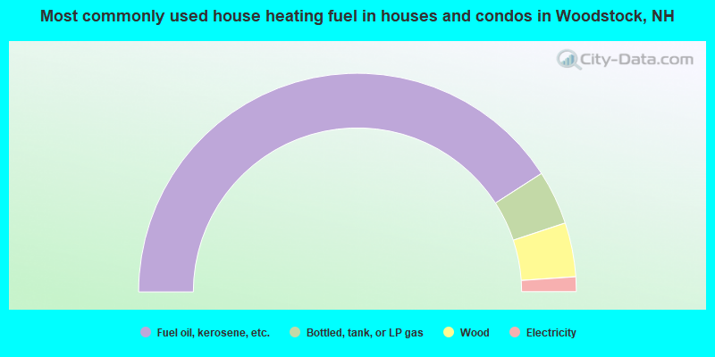
- 81.8%Fuel oil, kerosene, etc.
- 8.0%Bottled, tank, or LP gas
- 8.0%Wood
- 2.2%Electricity
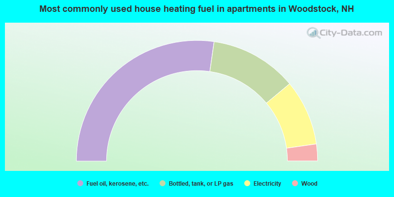
- 54.5%Fuel oil, kerosene, etc.
- 23.3%Bottled, tank, or LP gas
- 17.6%Electricity
- 4.5%Wood
Woodstock compared to New Hampshire state average:
- Unemployed percentage significantly below state average.
- Black race population percentage significantly below state average.
- Hispanic race population percentage significantly below state average.
- Foreign-born population percentage below state average.
- Length of stay since moving in significantly above state average.
- Number of rooms per house significantly below state average.
- House age significantly below state average.

|
Total of 1 patent application in 2008-2024.