Woolwich, Maine

Woolwich: sunset at the farm

Woolwich: icy morning sun
Woolwich: Mushroom on Stoney Creek Drive Woolwich
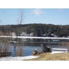
Woolwich: Clearing Ice on the Kennebec River

Woolwich

Woolwich: Mushroom on Stoney Creek Drive Woolwich
- add
your


Submit your own pictures of this town and show them to the world
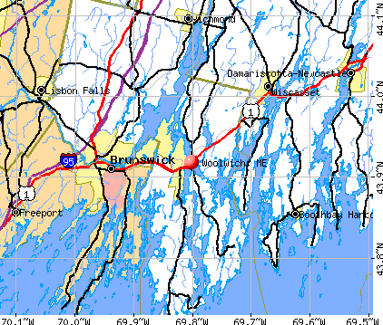
- OSM Map
- General Map
- Google Map
- MSN Map
Population change since 2000: +9.3%
 |
| Males: 1,519 | |
| Females: 1,553 |
| Median resident age: | 44.6 years |
| Maine median age: | 43.0 years |
Zip codes: 04579.
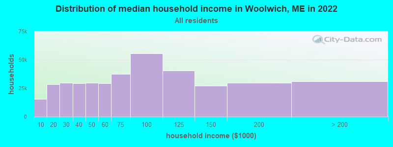
| Woolwich: | $78,745 |
| ME: | $69,543 |
Estimated per capita income in 2022: $43,964 (it was $21,097 in 2000)
Woolwich town income, earnings, and wages data
Estimated median house or condo value in 2022: $332,946 (it was $113,400 in 2000)
| Woolwich: | $332,946 |
| ME: | $290,600 |
Mean prices in 2022: all housing units: $359,191; detached houses: $377,995; townhouses or other attached units: $306,259; in 2-unit structures: $363,404; in 3-to-4-unit structures: $296,417; in 5-or-more-unit structures: $457,842; mobile homes: $167,878
Detailed information about poverty and poor residents in Woolwich, ME


- 2,94896.0%White alone
- 461.5%Two or more races
- 351.1%Hispanic
- 190.6%Asian alone
- 110.4%American Indian alone
- 80.3%Black alone
- 50.2%Other race alone
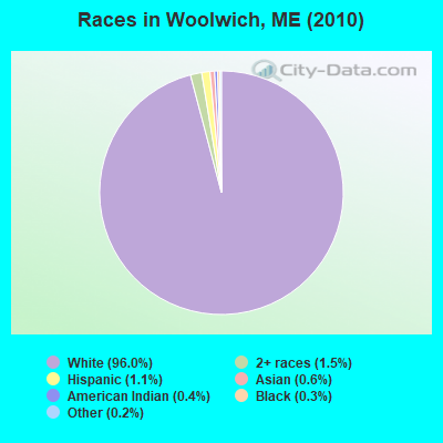
Races in Woolwich detailed stats: ancestries, foreign born residents, place of birth
According to our research of Maine and other state lists, there were 5 registered sex offenders living in Woolwich, Maine as of April 18, 2024.
The ratio of all residents to sex offenders in Woolwich is 614 to 1.
The ratio of registered sex offenders to all residents in this city is near the state average.
 Recent articles from our blog. Our writers, many of them Ph.D. graduates or candidates, create easy-to-read articles on a wide variety of topics.


 | Well, here goes. The start to our trek North to Maine, our new home-state. (395 replies) |
| Moving to ME from Hawaii (10 replies) |
| Bath undersung? (19 replies) |
| Brunswick Maine rentals (6 replies) |
| Coastal Maine Relocation Questions (37 replies) |
| Retiring to Maine coast, Need a rental while we look to buy (33 replies) |
Latest news from Woolwich, ME collected exclusively by city-data.com from local newspapers, TV, and radio stations
Woolwich, ME City Guides:
Ancestries: English (29.2%), Irish (17.5%), French (9.7%), United States (8.0%), German (7.9%), French Canadian (4.7%).
Current Local Time: EST time zone
Incorporated on 10/20/1759
Elevation: 50 feet
Land area: 35.0 square miles.
Population density: 88 people per square mile (very low).
58 residents are foreign born (0.9% Europe, 0.6% North America, 0.5% Asia).
| This town: | 2.1% |
| Maine: | 2.9% |
| Woolwich town: | 1.3% ($1,460) |
| Maine: | 1.5% ($1,417) |
Nearest city with pop. 50,000+: Portland, ME  (31.3 miles , pop. 64,249).
Nearest city with pop. 200,000+: Boston, MA (130.5 miles , pop. 589,141).
Nearest city with pop. 1,000,000+: Bronx, NY (299.5 miles , pop. 1,332,650).
Nearest cities:
), ), ), ), ), )Latitude: 43.95 N, Longitude: 69.78 W
Area code commonly used in this area: 207

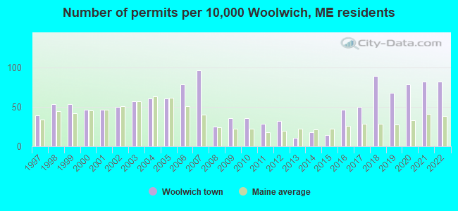
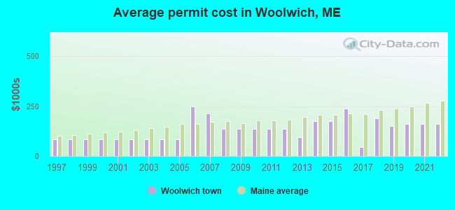
Single-family new house construction building permits:
- 2022: 23 buildings, average cost: $160,300
- 2021: 23 buildings, average cost: $159,700
- 2020: 22 buildings, average cost: $162,000
- 2019: 19 buildings, average cost: $151,600
- 2018: 25 buildings, average cost: $189,800
- 2017: 14 buildings, average cost: $44,600
- 2016: 13 buildings, average cost: $236,800
- 2015: 4 buildings, average cost: $175,000
- 2014: 5 buildings, average cost: $175,000
- 2013: 3 buildings, average cost: $93,300
- 2012: 9 buildings, average cost: $135,500
- 2011: 8 buildings, average cost: $135,500
- 2010: 10 buildings, average cost: $135,500
- 2009: 10 buildings, average cost: $135,500
- 2008: 7 buildings, average cost: $135,500
- 2007: 27 buildings, average cost: $213,100
- 2006: 22 buildings, average cost: $249,100
- 2005: 17 buildings, average cost: $83,400
- 2004: 17 buildings, average cost: $83,400
- 2003: 16 buildings, average cost: $83,400
- 2002: 14 buildings, average cost: $83,400
- 2001: 13 buildings, average cost: $83,400
- 2000: 13 buildings, average cost: $83,400
- 1999: 15 buildings, average cost: $83,400
- 1998: 15 buildings, average cost: $83,400
- 1997: 11 buildings, average cost: $83,400
| Here: | 3.3% |
| Maine: | 3.4% |
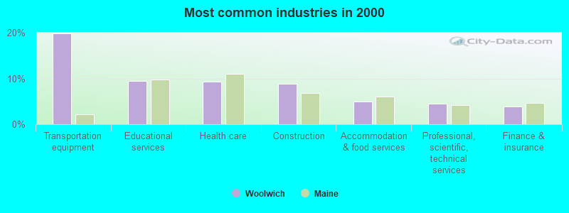
- Transportation equipment (19.8%)
- Educational services (9.4%)
- Health care (9.3%)
- Construction (8.8%)
- Accommodation & food services (5.0%)
- Professional, scientific, technical services (4.6%)
- Finance & insurance (3.8%)
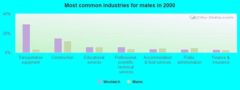
- Transportation equipment (29.5%)
- Construction (14.9%)
- Educational services (5.9%)
- Professional, scientific, technical services (5.8%)
- Accommodation & food services (3.7%)
- Public administration (3.3%)
- Finance & insurance (3.1%)
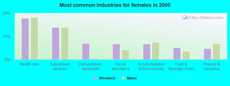
- Health care (17.9%)
- Educational services (13.9%)
- Transportation equipment (7.0%)
- Social assistance (6.7%)
- Accommodation & food services (6.7%)
- Food & beverage stores (5.1%)
- Finance & insurance (4.8%)
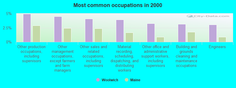
- Other production occupations, including supervisors (5.0%)
- Other management occupations, except farmers and farm managers (4.5%)
- Other sales and related occupations, including supervisors (4.1%)
- Material recording, scheduling, dispatching, and distributing workers (3.9%)
- Other office and administrative support workers, including supervisors (3.3%)
- Building and grounds cleaning and maintenance occupations (3.1%)
- Engineers (3.1%)
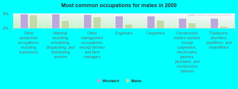
- Other production occupations, including supervisors (5.8%)
- Material recording, scheduling, dispatching, and distributing workers (5.8%)
- Other management occupations, except farmers and farm managers (5.6%)
- Engineers (5.0%)
- Carpenters (5.0%)
- Construction traders workers except carpenters, electricians, painters, plumbers, and construction laborers (4.0%)
- Pipelayers, plumbers, pipefitters, and steamfitters (4.0%)
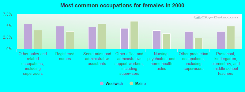
- Other sales and related occupations, including supervisors (5.4%)
- Registered nurses (4.9%)
- Secretaries and administrative assistants (4.8%)
- Other office and administrative support workers, including supervisors (4.4%)
- Nursing, psychiatric, and home health aides (4.0%)
- Other production occupations, including supervisors (3.8%)
- Preschool, kindergarten, elementary, and middle school teachers (3.8%)
Average climate in Woolwich, Maine
Based on data reported by over 4,000 weather stations


(lower is better)
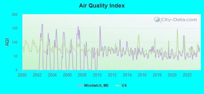
Air Quality Index (AQI) level in 2023 was 63.9. This is about average.
| City: | 63.9 |
| U.S.: | 72.6 |
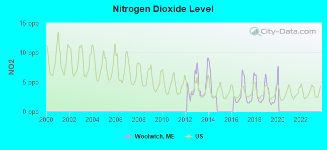
Nitrogen Dioxide (NO2) [ppb] level in 2019 was 2.80. This is significantly better than average. Closest monitor was 19.4 miles away from the city center.
| City: | 2.80 |
| U.S.: | 5.11 |
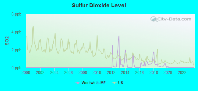
Sulfur Dioxide (SO2) [ppb] level in 2019 was 0.185. This is significantly better than average. Closest monitor was 2.8 miles away from the city center.
| City: | 0.185 |
| U.S.: | 1.515 |
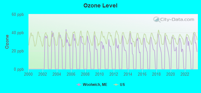
Ozone [ppb] level in 2023 was 30.6. This is about average. Closest monitor was 3.1 miles away from the city center.
| City: | 30.6 |
| U.S.: | 33.3 |
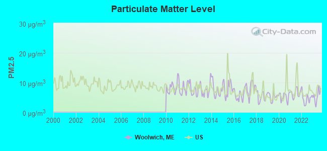
Particulate Matter (PM2.5) [µg/m3] level in 2023 was 5.52. This is significantly better than average. Closest monitor was 23.5 miles away from the city center.
| City: | 5.52 |
| U.S.: | 8.11 |
Earthquake activity:
Woolwich-area historical earthquake activity is significantly above Maine state average. It is 76% smaller than the overall U.S. average.On 10/16/2012 at 23:12:25, a magnitude 4.7 (4.7 ML, Depth: 10.0 mi, Class: Light, Intensity: IV - V) earthquake occurred 50.0 miles away from the city center
On 4/20/2002 at 10:50:47, a magnitude 5.3 (5.3 ML, Depth: 3.0 mi, Class: Moderate, Intensity: VI - VII) earthquake occurred 197.8 miles away from the city center
On 4/20/2002 at 10:50:47, a magnitude 5.2 (5.2 MB, 4.2 MS, 5.2 MW, 5.0 MW) earthquake occurred 198.5 miles away from Woolwich center
On 1/19/1982 at 00:14:42, a magnitude 4.7 (4.5 MB, 4.7 MD, 4.5 LG) earthquake occurred 96.0 miles away from Woolwich center
On 10/7/1983 at 10:18:46, a magnitude 5.3 (5.1 MB, 5.3 LG, 5.1 ML) earthquake occurred 227.0 miles away from the city center
On 2/26/1999 at 03:38:43, a magnitude 3.8 (3.8 LG, Depth: 2.0 mi, Class: Light, Intensity: II - III) earthquake occurred 38.9 miles away from Woolwich center
Magnitude types: regional Lg-wave magnitude (LG), body-wave magnitude (MB), duration magnitude (MD), local magnitude (ML), surface-wave magnitude (MS), moment magnitude (MW)
Natural disasters:
The number of natural disasters in Sagadahoc County (19) is greater than the US average (15).Major Disasters (Presidential) Declared: 14
Emergencies Declared: 4
Causes of natural disasters: Floods: 12, Storms: 10, Winter Storms: 6, Hurricanes: 2, Snows: 2, Blizzard: 1, Ice Storm: 1, Snowfall: 1, Snowstorm: 1, Wind: 1, Other: 1 (Note: some incidents may be assigned to more than one category).

Hospitals and medical centers near Woolwich:
- WINSHIP GREEN NURSING CENTER (Nursing Home, about 3 miles away; BATH, ME)
- COASTAL DIALYSIS CENTER (Dialysis Facility, about 4 miles away; BATH, ME)
- ST ANDREWS HOME HEALTH (Home Health Center, about 10 miles away; BOOTHBAY HARBOR, ME)
- ST ANDREWS HOSPITAL (LINCOLN COUNTY HEALTHCARE) Critical Access Hospitals (about 10 miles away; BOOTHBAY HARBOR, ME)
- BRUNSWICK MANOR (Nursing Home, about 10 miles away; BRUNSWICK, ME)
- MID COAST SENIOR HEALTH CENTER (Nursing Home, about 11 miles away; BRUNSWICK, ME)
- COMMUNITY HEALTH AND NURSING SERVICES (Home Health Center, about 11 miles away; BRUNSWICK, ME)
Colleges/universities with over 2000 students nearest to Woolwich:
- University of Maine at Augusta (about 27 miles; Augusta, ME; Full-time enrollment: 3,204)
- Southern Maine Community College (about 31 miles; South Portland, ME; FT enrollment: 4,666)
- University of Southern Maine (about 32 miles; Portland, ME; FT enrollment: 6,647)
- Saint Joseph's College of Maine (about 36 miles; Standish, ME; FT enrollment: 2,010)
- University of New England (about 46 miles; Biddeford, ME; FT enrollment: 4,539)
- University of Maine at Farmington (about 53 miles; Farmington, ME; FT enrollment: 2,036)
- Husson University (about 79 miles; Bangor, ME; FT enrollment: 2,421)
Private high school in Woolwich:
Public elementary/middle school in Woolwich:
- WOOLWICH CENTRAL SCHOOL (Location: 137 NEQUASSET ROAD, Grades: PK-8)
Points of interest:
Notable locations in Woolwich: Chops Crossroads (A), Chop Point Camp (B), Woolwich Volunteer Fire Department North Station (C), Woolwich Town House (D), Woolwich Fire Department (E). Display/hide their locations on the map
Churches in Woolwich include: Center Church (A), Bath Foursquare Church (B), Woolwich-Wiscasset Church (C). Display/hide their locations on the map
Cemeteries: Bailey Cemetery (1), Murphys Corner Cemetery (2), Riverside Cemetery (3), Laurel Grove Cemetery (4), Hodgkins Cemetery (5), Grover Cemetery (6). Display/hide their locations on the map
Lakes and reservoirs: Wolf Pond (A), Montsweag Reservoir (B), Nequasset Lake (C). Display/hide their locations on the map
Streams, rivers, and creeks: Back River Creek (A), Brox Creek (B), Montsweag Brook (C), Chops Creek (D), Nequasset Brook (E). Display/hide their locations on the map
Parks in Woolwich include: Days Ferry Historic District (1), Robert P Tristam Coffin Wildflower Sanctuary (2). Display/hide their locations on the map
Birthplace of: William Phips - Royal governor of the Province of Massachusetts Bay.
Drinking water stations with addresses in Woolwich and their reported violations in the past:
CHOP POINT (GREENHOUSE) (Population served: 120, Groundwater):Past health violations:MAPLEWOOD MOBILE HOME PARK (Population served: 75, Groundwater):Past monitoring violations:
- MCL, Monthly (TCR) - In JUL-2010, Contaminant: Coliform. Follow-up actions: St Public Notif requested (JUL-09-2010), St Formal NOV issued (JUL-09-2010), St Public Notif received (JUL-20-2010), St Compliance achieved (AUG-26-2011)
- MCL, Monthly (TCR) - In JUN-2010, Contaminant: Coliform. Follow-up actions: St Public Notif requested (JUN-24-2010), St Formal NOV issued (JUN-24-2010), St Compliance achieved (AUG-26-2011), St Public Notif received (MAR-22-2012)
- 2 routine major monitoring violations
Past health violations:
- MCL, Monthly (TCR) - In JUN-2006, Contaminant: Coliform. Follow-up actions: St Public Notif requested (JUN-26-2006), St Violation/Reminder Notice (JUN-26-2006), St Public Notif received (2 times from AUG-29-2006 to SEP-10-2007), St Compliance achieved (SEP-10-2007)
- MCL, Monthly (TCR) - In MAY-2006, Contaminant: Coliform. Follow-up actions: St Violation/Reminder Notice (MAY-18-2006), St Public Notif requested (MAY-18-2006), St Public Notif received (2 times from JUN-14-2006 to SEP-10-2007), St Compliance achieved (SEP-10-2007)
- MCL, Monthly (TCR) - In DEC-2005, Contaminant: Coliform. Follow-up actions: St Violation/Reminder Notice (JAN-03-2006), St Public Notif requested (JAN-03-2006), St Public Notif received (2 times from JAN-31-2006 to SEP-10-2007), St Compliance achieved (SEP-10-2007)
- MCL, Monthly (TCR) - In JUN-2005, Contaminant: Coliform. Follow-up actions: St Violation/Reminder Notice (JUN-29-2005), St Public Notif requested (JUN-29-2005), St Public Notif received (2 times from JUL-21-2005 to JUL-21-2005), St Compliance achieved (SEP-10-2007), St Public Notif received (SEP-10-2007)
| This town: | 2.5 people |
| Maine: | 2.3 people |
| This town: | 73.2% |
| Whole state: | 62.9% |
| This town: | 9.4% |
| Whole state: | 9.4% |
Likely homosexual households (counted as self-reported same-sex unmarried-partner households)
- Lesbian couples: 0.6% of all households
- Gay men: 0.5% of all households
| This town: | 6.1% |
| Whole state: | 10.9% |
| This town: | 1.2% |
| Whole state: | 4.1% |
For population 15 years and over in Woolwich:
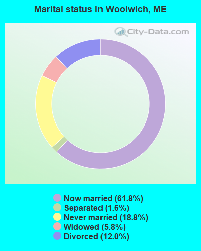
- Never married: 18.8%
- Now married: 61.8%
- Separated: 1.6%
- Widowed: 5.8%
- Divorced: 12.0%
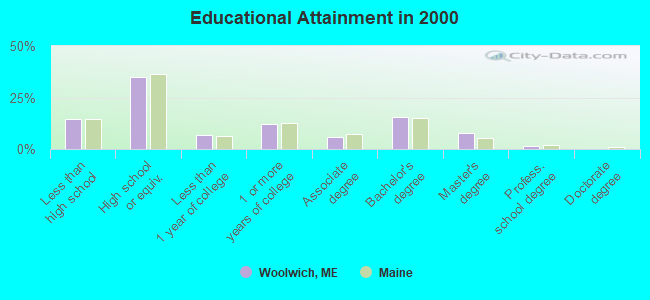
For population 25 years and over in Woolwich:
- High school or higher: 85.5%
- Bachelor's degree or higher: 24.9%
- Graduate or professional degree: 9.4%
- Unemployed: 1.6%
- Mean travel time to work (commute): 23.2 minutes
| Here: | 10.2 |
| Maine average: | 11.2 |
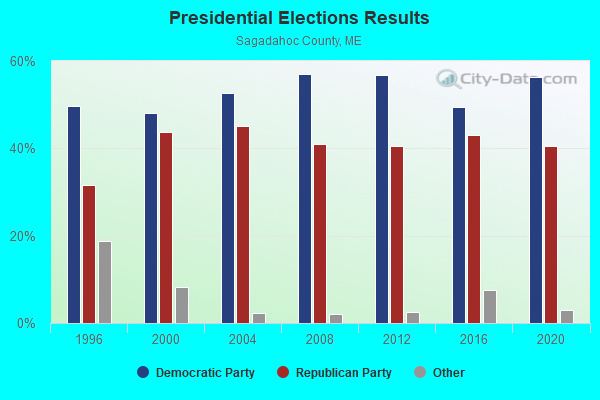
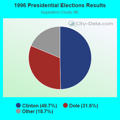
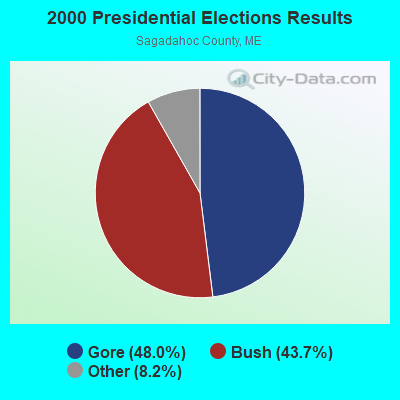
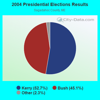

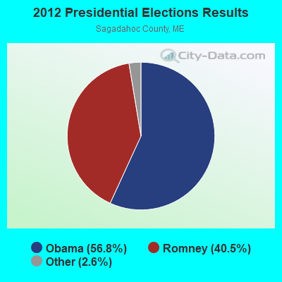
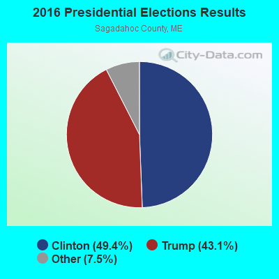
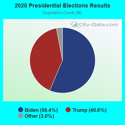
Graphs represent county-level data. Detailed 2008 Election Results
Religion statistics for Woolwich, ME (based on Sagadahoc County data)
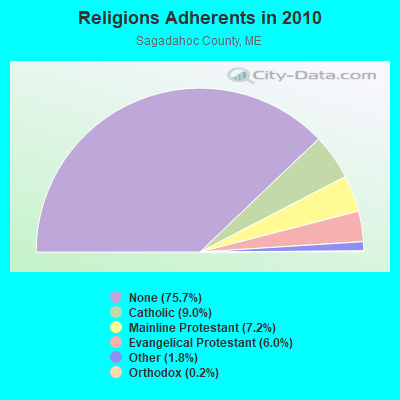
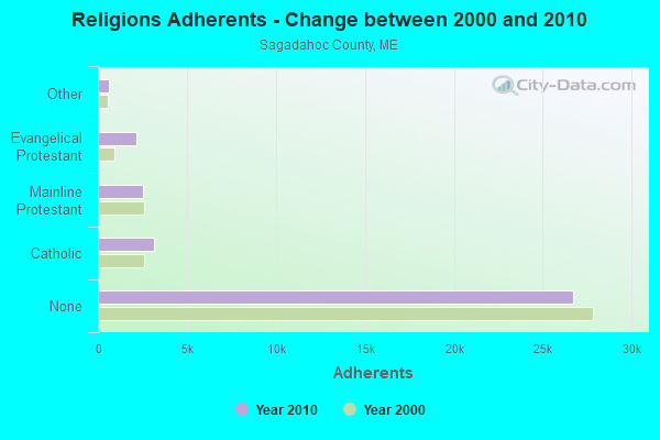
| Religion | Adherents | Congregations |
|---|---|---|
| Catholic | 3,177 | 3 |
| Mainline Protestant | 2,527 | 15 |
| Evangelical Protestant | 2,134 | 20 |
| Other | 646 | 2 |
| Orthodox | 88 | 1 |
| None | 26,721 | - |
Food Environment Statistics:
| Sagadahoc County: | 1.65 / 10,000 pop. |
| Maine: | 2.80 / 10,000 pop. |
| Here: | 1.93 / 10,000 pop. |
| Maine: | 2.20 / 10,000 pop. |
| This county: | 4.40 / 10,000 pop. |
| Maine: | 5.75 / 10,000 pop. |
| Sagadahoc County: | 10.18 / 10,000 pop. |
| Maine: | 11.02 / 10,000 pop. |
| Sagadahoc County: | 7.7% |
| Maine: | 8.2% |
| Sagadahoc County: | 26.5% |
| State: | 25.0% |
Businesses in Woolwich, ME
- Dairy Queen: 1
- Subaru: 1
Strongest AM radio stations in Woolwich:
- WJTO (730 AM; 1 kW; BATH, ME; Owner: BLUE JEY BROADCASTING COMPANY)
- WJJB (900 AM; 1 kW; BRUNSWICK, ME; Owner: ATLANTIC COAST RADIO, LLC)
- WFAU (1280 AM; 5 kW; GARDINER, ME; Owner: CAPSTAR TX LIMITED PARTNERSHIP)
- WGAN (560 AM; 5 kW; PORTLAND, ME; Owner: SAGA COMMUNICATIONS OF NEW ENGLAND, LLC)
- WMTW (870 AM; 10 kW; GORHAM, ME; Owner: RADIO PARTNERS OF MAINE, L.P.)
- WLAM (1470 AM; 5 kW; LEWISTON, ME; Owner: RADIO PARTNERS OF MAINE, L.P.)
- WRKO (680 AM; 50 kW; BOSTON, MA; Owner: ENTERCOM BOSTON LICENSE, LLC)
- WTME (780 AM; 10 kW; RUMFORD, ME; Owner: MOUNTAIN VALLEY BROADCASTING, INC.)
- WZAN (970 AM; 5 kW; PORTLAND, ME; Owner: SAGA COMMUNICATIONS OF NEW ENGLAND, LLC)
- WLOB (1310 AM; 5 kW; PORTLAND, ME; Owner: ATLANTIC COAST RADIO, LLC)
- WEEI (850 AM; 50 kW; BOSTON, MA; Owner: ENTERCOM BOSTON LICENSE, LLC)
- WBZ (1030 AM; 50 kW; BOSTON, MA; Owner: INFINITY BROADCASTING OPERATIONS, INC.)
- WJAE (1440 AM; 5 kW; WESTBROOK, ME; Owner: ALTANTIC COAST RADIO, LLC)
Strongest FM radio stations in Woolwich:
- WCLZ (98.9 FM; BRUNSWICK, ME; Owner: CITADEL BROADCASTING COMPANY)
- WBCI (105.9 FM; BATH, ME; Owner: BLOUNT COMMUNICATIONS, INC.)
- WCME (96.7 FM; BOOTHBAY HARBOR, ME; Owner: CAPSTAR TX LIMITED PARTNERSHIP)
- WJJB-FM (95.5 FM; TOPSHAM, ME; Owner: ATLANTIC COAST RADIO, LLC)
- WCYI (93.9 FM; LEWISTON, ME; Owner: CITADEL BROADCASTING COMPANY)
- WBLM (102.9 FM; PORTLAND, ME; Owner: CITADEL BROADCASTING COMPANY)
- WTHT (107.5 FM; LEWISTON, ME; Owner: RADIO PARTNERS OF MAINE, L.P.)
- WPKQ (103.7 FM; NORTH CONWAY, NH; Owner: CITADEL BROADCASTING COMPANY)
- WMEA (90.1 FM; PORTLAND, ME; Owner: MAINE PUBLIC BROADCASTING CORPORATION)
- WHOM (94.9 FM; MT. WASHINGTON, NH; Owner: CITADEL BROADCASTING COMPANY)
- WJBQ (97.9 FM; PORTLAND, ME; Owner: CITADEL BROADCASTING COMPANY)
- WMEP (90.5 FM; CAMDEN, ME; Owner: MAINE PUBLIC BROADCASTING CORP.)
- WQSS (102.5 FM; CAMDEN, ME; Owner: CLEAR CHANNEL BROADCASTING LICENSES, INC.)
- WMEK-FM (99.9 FM; AUBURN, ME; Owner: RADIO PARTNERS OF MAINE, L.P.)
- WMTW-FM (106.7 FM; NORTH WINDHAM, ME; Owner: RADIO PARTNERS OF MAINE, L.P.)
- WMCM (103.3 FM; ROCKLAND, ME; Owner: CLEAR CHANNEL BROADCASTING LICENSES, INC.)
- WYFP (91.9 FM; HARPSWELL, ME; Owner: BIBLE BROADCASTING NETWORK, INC.)
- WPOR (101.9 FM; PORTLAND, ME; Owner: SAGA COMMUNICATIONS OF NEW ENGLAND, LLC)
- WMME-FM (92.3 FM; AUGUSTA, ME; Owner: CITADEL BROADCASTING COMPANY)
- WBQX (106.9 FM; THOMASTON, ME; Owner: MARINER BROADCASTING LIMITED PARTNER)
TV broadcast stations around Woolwich:
- WPFO (Channel 23; WATERVILLE, ME; Owner: CMCG PORTLAND LICENSE LLC)
- WGME-TV (Channel 13; PORTLAND, ME; Owner: WGME LICENSEE, LLC)
- WCBB (Channel 10; AUGUSTA, ME; Owner: MAINE PUBLIC BROADCASTING CORP.)
- WMTW-TV (Channel 8; POLAND SPRING, ME; Owner: WMTW BROADCAST GROUP, LLC)
- WPXT (Channel 51; PORTLAND, ME; Owner: HMW, INC.)
- WCSH (Channel 6; PORTLAND, ME; Owner: PACIFIC AND SOUTHERN COMPANY, INC.)
- WPME (Channel 35; LEWISTON, ME; Owner: KB PRIME MEDIA LLC)
- W32CA (Channel 32; PORTLAND, ME; Owner: NATIONAL MINORITY T.V., INC.)
- W29CA (Channel 29; BRUNSWICK, ME; Owner: CRAIG MINISTRIES)
- National Bridge Inventory (NBI) Statistics
- 9Number of bridges
- 141ft / 42.6mTotal length
- 73,492Total average daily traffic
- 3,672Total average daily truck traffic
- 103,367Total future (year 2034) average daily traffic
FCC Registered Antenna Towers:
31 (See the full list of FCC Registered Antenna Towers in Woolwich)FCC Registered Broadcast Land Mobile Towers:
2- Walker Rd (Lat: 43.978417 Lon: -69.732556), Type: Bant, Structure height: 15.2 m, Call Sign: KES732,
Assigned Frequencies: 151.775 MHz, Grant Date: 03/16/2023, Expiration Date: 03/02/2033, Registrant: Jack A. Shaw & Sons, Inc., 911 Old Stage Road, Woolwich, ME 04579, Phone: (207) 443-3932, Email:
- 425 Chops Point Rd (Lat: 43.983222 Lon: -69.828139), Type: Upole, Structure height: 74.4 m, Overall height: 74.7 m, Call Sign: WRHZ402,
Assigned Frequencies: 9220.00 MHz, Grant Date: 07/20/2020, Expiration Date: 07/20/2030, Certifier: Jenna Muzzy, Registrant: Central Maine Power Company, 83 Edison Drive, Augusta, ME 04336, Phone: (800) 750-2976, Email:
FCC Registered Microwave Towers:
1- Nequasset Rd (Lat: 43.944278 Lon: -69.775528), Structure height: 10.7 m, Overall height: 12.2 m, Call Sign: WPNL586,
Assigned Frequencies: 928.393 MHz, 952.393 MHz, Grant Date: 03/31/1998, Expiration Date: 03/31/2008, Cancellation Date: 05/31/2008, Phone: (716) 242-8444
FCC Registered Amateur Radio Licenses:
28 (See the full list of FCC Registered Amateur Radio Licenses in Woolwich)FAA Registered Aircraft:
3- Aircraft: MAULE M-4-220C (Category: Land, Seats: 4, Weight: Up to 12,499 Pounds, Speed: 108 mph), Engine: FRANKLIN 6V 350 SERIES (235 HP) (Reciprocating)
N-Number: 40326, N40326, N-40326, Serial Number: 2101C, Year manufactured: 1972, Certificate Issue Date: 01/28/2011
Registrant (Individual): Andrew M Rice, 3 Eagle Cove, Woolwich, ME 04579 - Aircraft: PIPER PA-28-140 (Category: Land, Seats: 4, Weight: Up to 12,499 Pounds, Speed: 107 mph), Engine: LYCOMING 0-340 SERIES (170 HP) (Reciprocating)
N-Number: 498FL, N498FL, N-498FL, Serial Number: 28-7125315, Year manufactured: 1971, Airworthiness Date: 03/26/1971, Certificate Issue Date: 04/21/2016
Registrant (LLC): Farmers Aviation LLC, 300 George Wright Rd, Woolwich, ME 04579 - Aircraft: CESSNA 172M (Category: Land, Seats: 4, Weight: Up to 12,499 Pounds, Speed: 108 mph), Engine: LYCOMING 0-320 SERIES (180 HP) (4 Cycle)
N-Number: 9641V, N9641V, N-9641V, Serial Number: 17264421, Year manufactured: 1974, Airworthiness Date: 12/02/1974, Certificate Issue Date: 02/12/2002
Registrant (Individual): Douglas B Rink, 27 Delano Rd, Woolwich, ME 04579
2003 - 2018 National Fire Incident Reporting System (NFIRS) incidents
- Fire incident types reported to NFIRS in Woolwich, ME
- 6750.4%Structure Fires
- 4433.1%Outside Fires
- 1612.0%Other
- 64.5%Mobile Property/Vehicle Fires
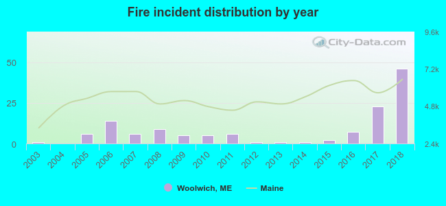 According to the data from the years 2003 - 2018 the average number of fires per year is 8. The highest number of fires - 46 took place in 2018, and the least - 0 in 2004. The data has a growing trend.
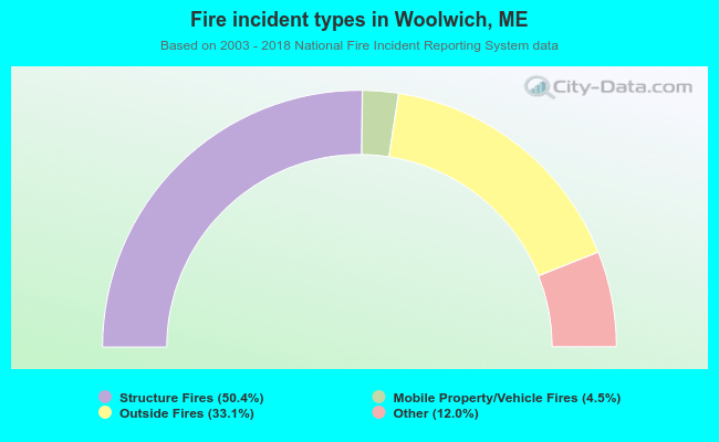 When looking into fire subcategories, the most reports belonged to: Structure Fires (50.4%), and Outside Fires (33.1%).
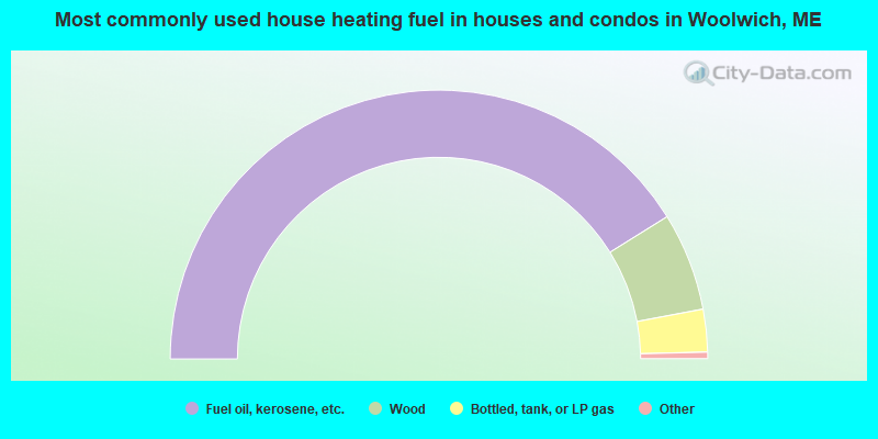
- 82.2%Fuel oil, kerosene, etc.
- 11.8%Wood
- 5.1%Bottled, tank, or LP gas
- 0.5%Utility gas
- 0.3%Electricity
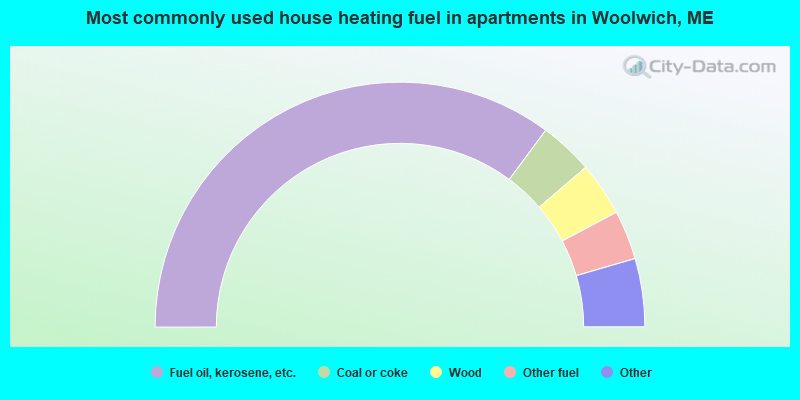
- 70.3%Fuel oil, kerosene, etc.
- 7.1%Coal or coke
- 7.1%Wood
- 6.5%Other fuel
- 3.2%Bottled, tank, or LP gas
- 3.2%Electricity
- 2.6%No fuel used
Woolwich compared to Maine state average:
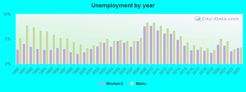
- Unemployed percentage significantly below state average.
- Black race population percentage significantly below state average.
- Foreign-born population percentage below state average.
- Renting percentage significantly below state average.
- Length of stay since moving in significantly above state average.
- Number of rooms per house significantly below state average.
- House age significantly below state average.
State forum archive:

|
|
Total of 26 patent applications in 2008-2024.