Woxhall, Pennsylvania
Submit your own pictures of this place and show them to the world
- OSM Map
- Google Map
- MSN Map
| Males: 666 | |
| Females: 652 |
| Median resident age: | 45.0 years |
| Pennsylvania median age: | 40.9 years |
| Woxhall: | $106,811 |
| PA: | $71,798 |
Estimated per capita income in 2022: $58,446
Woxhall CDP income, earnings, and wages data
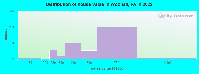
Estimated median house or condo value in 2022: $413,100
| Woxhall: | $413,100 |
| PA: | $245,500 |
Mean prices in 2022: all housing units: $451,310; detached houses: $444,771
Detailed information about poverty and poor residents in Woxhall, PA


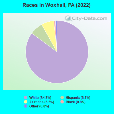
- 1,19084.7%White alone
- 946.7%Hispanic
- 926.5%Two or more races
- 110.8%Black alone
- 110.8%Other race alone
Races in Woxhall detailed stats: ancestries, foreign born residents, place of birth
 Recent articles from our blog. Our writers, many of them Ph.D. graduates or candidates, create easy-to-read articles on a wide variety of topics.

Ancestries: German (39.3%), Polish (13.1%), American (10.0%), Slovak (7.4%), Irish (5.1%), Pennsylvania German (3.9%).
Current Local Time: EST time zone
45 residents are foreign born (2.7% Latin America, 0.4% Europe).
| This place: | 3.2% |
| Pennsylvania: | 7.3% |
Median real estate property taxes paid for housing units with mortgages in 2022: $9,200 (1.6%)
Median real estate property taxes paid for housing units with no mortgage in 2022: $5,789 (1.6%)
Nearest city with pop. 50,000+: Allentown, PA  (20.2 miles , pop. 106,632).
Nearest city with pop. 200,000+: Philadelphia, PA (27.0 miles , pop. 1,517,550).
Nearest cities:
), ), Latitude: 40.31 N, Longitude: 75.45 W
| Here: | 2.4% |
| Pennsylvania: | 2.9% |
(lower is better)
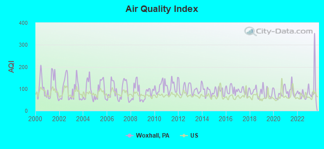
Air Quality Index (AQI) level in 2023 was 106. This is significantly worse than average.
| City: | 106 |
| U.S.: | 73 |
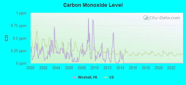
Carbon Monoxide (CO) [ppm] level in 2013 was 0.0642. This is significantly better than average. Closest monitor was 15.7 miles away from the city center.
| City: | 0.0642 |
| U.S.: | 0.2513 |
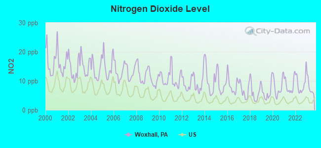
Nitrogen Dioxide (NO2) [ppb] level in 2023 was 7.85. This is significantly worse than average. Closest monitor was 15.7 miles away from the city center.
| City: | 7.85 |
| U.S.: | 5.11 |
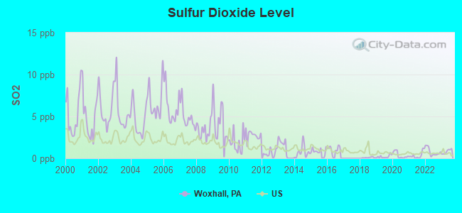
Sulfur Dioxide (SO2) [ppb] level in 2023 was 0.803. This is significantly better than average. Closest monitor was 9.6 miles away from the city center.
| City: | 0.803 |
| U.S.: | 1.515 |

Ozone [ppb] level in 2022 was 31.2. This is about average. Closest monitor was 15.7 miles away from the city center.
| City: | 31.2 |
| U.S.: | 33.3 |
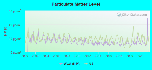
Particulate Matter (PM10) [µg/m3] level in 2022 was 13.0. This is significantly better than average. Closest monitor was 15.7 miles away from the city center.
| City: | 13.0 |
| U.S.: | 19.2 |
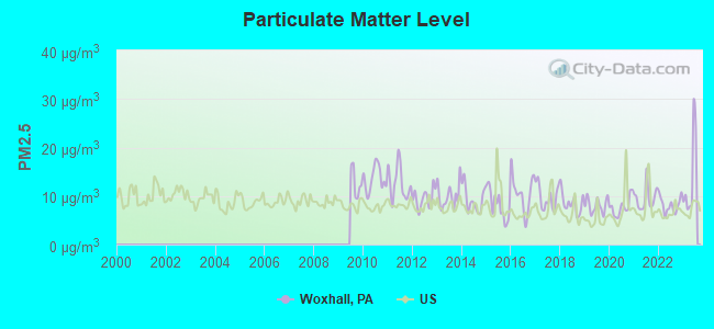
Particulate Matter (PM2.5) [µg/m3] level in 2023 was 13.8. This is significantly worse than average. Closest monitor was 15.7 miles away from the city center.
| City: | 13.8 |
| U.S.: | 8.1 |
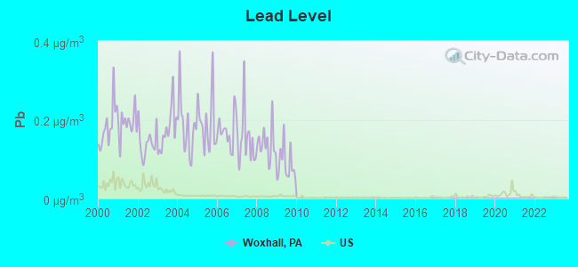
Lead (Pb) [µg/m3] level in 2009 was 0.0873. This is significantly worse than average. Closest monitor was 9.6 miles away from the city center.
| City: | 0.0873 |
| U.S.: | 0.0093 |
Tornado activity:
Woxhall-area historical tornado activity is slightly above Pennsylvania state average. It is 8% greater than the overall U.S. average.
On 7/27/1994, a category F3 (max. wind speeds 158-206 mph) tornado 6.6 miles away from the Woxhall place center killed 3 people and injured 25 people and caused between $5,000,000 and $50,000,000 in damages.
On 3/22/1955, a category F3 tornado 18.0 miles away from the place center killed one person and caused between $50,000 and $500,000 in damages.
Earthquake activity:
Woxhall-area historical earthquake activity is significantly above Pennsylvania state average. It is 66% smaller than the overall U.S. average.On 8/23/2011 at 17:51:04, a magnitude 5.8 (5.8 MW, Depth: 3.7 mi, Class: Moderate, Intensity: VI - VII) earthquake occurred 212.9 miles away from the city center
On 1/16/1994 at 01:49:16, a magnitude 4.6 (4.6 MB, 4.6 LG, Depth: 3.1 mi, Class: Light, Intensity: IV - V) earthquake occurred 30.9 miles away from the city center
On 1/16/1994 at 00:42:43, a magnitude 4.2 (4.2 MB, 4.0 LG, Depth: 3.1 mi) earthquake occurred 29.3 miles away from the city center
On 10/7/1983 at 10:18:46, a magnitude 5.3 (5.1 MB, 5.3 LG, 5.1 ML) earthquake occurred 258.3 miles away from Woxhall center
On 9/25/1998 at 19:52:52, a magnitude 5.2 (4.8 MB, 4.3 MS, 5.2 LG, 4.5 MW, Depth: 3.1 mi) earthquake occurred 271.0 miles away from the city center
On 4/20/2002 at 10:50:47, a magnitude 5.3 (5.3 ML, Depth: 3.0 mi) earthquake occurred 304.1 miles away from Woxhall center
Magnitude types: regional Lg-wave magnitude (LG), body-wave magnitude (MB), local magnitude (ML), surface-wave magnitude (MS), moment magnitude (MW)
Natural disasters:
The number of natural disasters in Montgomery County (26) is a lot greater than the US average (15).Major Disasters (Presidential) Declared: 20
Emergencies Declared: 6
Causes of natural disasters: Hurricanes: 7, Floods: 5, Winter Storms: 5, Storms: 4, Tropical Storms: 4, Snowstorms: 3, Blizzard: 1, Mudslide: 1, Snowfall: 1, Tropical Depression: 1, Water Shortage: 1, Other: 1 (Note: some incidents may be assigned to more than one category).
Hospitals and medical centers near Woxhall:
- INDIAN CREEK/PERK RD (Hospital, about 1 miles away; HARLEYSVILLE, PA)
- LIFEPATH, INC (Hospital, about 3 miles away; PENNSBURG, PA)
- LIFEPATH, INC (Hospital, about 4 miles away; HARLEYSVILLE, PA)
- PETER BECKER COMMUNITY (Nursing Home, about 5 miles away; HARLEYSVILLE, PA)
- INDIAN CREEK/FRANCONIA (Hospital, about 5 miles away; TELFORD, PA)
- INDIAN CREEK/LANDIS (Hospital, about 5 miles away; HARLEYSVILLE, PA)
- INDIAN CREEK KULP ROAD (Hospital, about 5 miles away; HARLEYSVILLE, PA)
Operable nuclear power plants near Woxhall:
- 11 miles: Limerick 1 and 2 in Pottstown, PA.
Colleges/universities with over 2000 students nearest to Woxhall:
- Montgomery County Community College (about 14 miles; Blue Bell, PA; Full-time enrollment: 8,723)
- Gwynedd Mercy University (about 14 miles; Gwynedd Valley, PA; FT enrollment: 2,125)
- Delaware Valley College (about 16 miles; Doylestown, PA; FT enrollment: 2,025)
- DeSales University (about 17 miles; Center Valley, PA; FT enrollment: 2,862)
- Cabrini College (about 19 miles; Radnor, PA; FT enrollment: 2,304)
- Eastern University (about 19 miles; Saint Davids, PA; FT enrollment: 3,220)
- Villanova University (about 20 miles; Villanova, PA; FT enrollment: 9,350)
Points of interest:
Churches in Woxhall include: Old Goshenhoppen Church (A), Tabor Church (B). Display/hide their locations on the map
Cemetery: Old Goschenhoppen Cemetery (1). Display/hide its location on the map
| This place: | 3.0 people |
| Pennsylvania: | 2.5 people |
| This place: | 85.1% |
| Whole state: | 65.0% |
| This place: | 4.3% |
| Whole state: | 6.6% |
Likely homosexual households (counted as self-reported same-sex unmarried-partner households)
- Lesbian couples: 0.9% of all households
- Gay men: 0.0% of all households
For population 15 years and over in Woxhall:
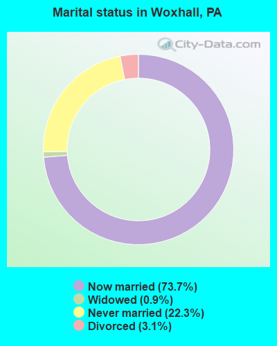
- Never married: 22.3%
- Now married: 73.7%
- Separated: 0.0%
- Widowed: 0.9%
- Divorced: 3.1%
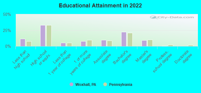
For population 25 years and over in Woxhall:
- High school or higher: 88.9%
- Bachelor's degree or higher: 31.2%
- Graduate or professional degree: 9.1%
- Mean travel time to work (commute): 20.3 minutes
| Here: | 9.1 |
| Pennsylvania average: | 11.4 |
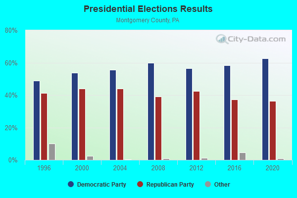
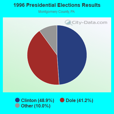
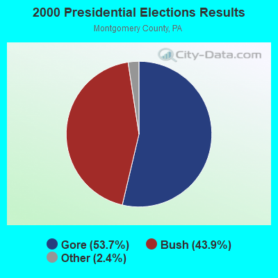
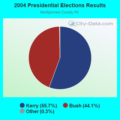
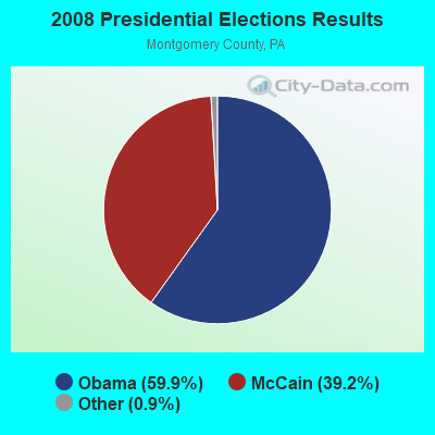
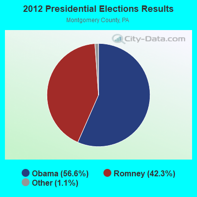
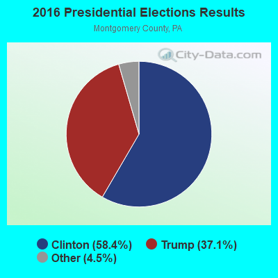
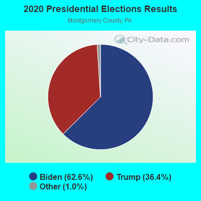
Graphs represent county-level data. Detailed 2008 Election Results
Religion statistics for Woxhall, PA (based on Montgomery County data)
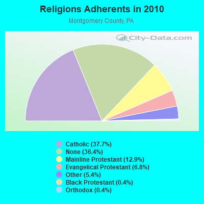
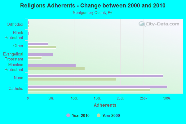
| Religion | Adherents | Congregations |
|---|---|---|
| Catholic | 301,220 | 55 |
| Mainline Protestant | 103,475 | 221 |
| Evangelical Protestant | 54,215 | 269 |
| Other | 43,532 | 68 |
| Black Protestant | 3,190 | 11 |
| Orthodox | 2,945 | 9 |
| None | 291,297 | - |
Food Environment Statistics:
| Here: | 1.63 / 10,000 pop. |
| Pennsylvania: | 2.04 / 10,000 pop. |
| Montgomery County: | 0.05 / 10,000 pop. |
| State: | 0.09 / 10,000 pop. |
| Montgomery County: | 1.16 / 10,000 pop. |
| Pennsylvania: | 0.88 / 10,000 pop. |
| Montgomery County: | 1.77 / 10,000 pop. |
| Pennsylvania: | 2.52 / 10,000 pop. |
| This county: | 7.61 / 10,000 pop. |
| State: | 7.12 / 10,000 pop. |
| This county: | 8.3% |
| Pennsylvania: | 9.1% |
| This county: | 23.4% |
| State: | 27.2% |
| Montgomery County: | 10.8% |
| Pennsylvania: | 11.5% |
6.73% of this county's 2021 resident taxpayers lived in other counties in 2020 ($101,242 average adjusted gross income)
| Here: | 6.73% |
| Pennsylvania average: | 5.27% |
0.01% of residents moved from foreign countries ($62 average AGI)
Montgomery County: 0.01% Pennsylvania average: 0.01%
Top counties from which taxpayers relocated into this county between 2020 and 2021:
| from Philadelphia County, PA | |
| from Bucks County, PA | |
| from Chester County, PA |
6.38% of this county's 2020 resident taxpayers moved to other counties in 2021 ($104,034 average adjusted gross income)
| Here: | 6.38% |
| Pennsylvania average: | 5.44% |
0.01% of residents moved to foreign countries ($121 average AGI)
Montgomery County: 0.01% Pennsylvania average: 0.01%
Top counties to which taxpayers relocated from this county between 2020 and 2021:
| to Philadelphia County, PA | |
| to Bucks County, PA | |
| to Chester County, PA |
Strongest AM radio stations in Woxhall:
- WWJZ (640 AM; 50 kW; MOUNT HOLLY, NJ; Owner: ABC, INC.)
- WZZD (990 AM; 50 kW; PHILADELPHIA, PA; Owner: PENNSYLVANIA MEDIA ASSOCIATES, INC.)
- KYW (1060 AM; 50 kW; PHILADELPHIA, PA; Owner: INFINITY BROADCASTING OPERATIONS, INC.)
- WWDB (860 AM; daytime; 10 kW; PHILADELPHIA, PA)
- WPEN (950 AM; 50 kW; PHILADELPHIA, PA; Owner: GREATER PHILADELPHIA RADIO, INC.)
- WVCH (740 AM; 50 kW; CHESTER, PA; Owner: WVCH COMMUNICATIONS, INC.)
- WNWR (1540 AM; 50 kW; PHILADELPHIA, PA)
- WPHT (1210 AM; 50 kW; PHILADELPHIA, PA; Owner: INFINITY BROADCASTING OPERATIONS, INC.)
- WEEU (830 AM; 20 kW; READING, PA; Owner: WEEU BROADCASTING COMPANY)
- WFIL (560 AM; 5 kW; PHILADELPHIA, PA; Owner: PENNSYLVANIA MEDIA ASSOCIATES, INC.)
- WNPV (1440 AM; 2 kW; LANSDALE, PA; Owner: WNPV INC.)
- WNAP (1110 AM; daytime; 5 kW; NORRISTOWN, PA; Owner: WNAP, INC)
- WISP (1570 AM; 5 kW; DOYLESTOWN, PA; Owner: HOLY SPIRIT RADIO FOUNDATION, INC.)
Strongest FM radio stations in Woxhall:
- WBYO (88.9 FM; SELLERSVILLE, PA; Owner: FOUR RIVERS COMMUNITY BROADCASTING CORP)
- WBYN (107.5 FM; BOYERTOWN, PA; Owner: WDAC RADIO COMPANY)
- WLEV (100.7 FM; ALLENTOWN, PA; Owner: CITADEL BROADCASTING COMPANY)
- WMWX (95.7 FM; PHILADELPHIA, PA; Owner: GREATER PHILADELPHIA RADIO, INC.)
- WMGK (102.9 FM; PHILADELPHIA, PA; Owner: GREATER PHILADELPHIA RADIO, INC.)
- WDIY (88.1 FM; ALLENTOWN, PA; Owner: LEHIGH VALLEY COMMUNITY BR/CST ASSOC)
- WOGL (98.1 FM; PHILADELPHIA, PA; Owner: INFINITY BROADCASTING OPERATIONS, INC.)
- WJCS (89.3 FM; ALLENTOWN, PA; Owner: BEACON BROADCASTING CORPORATION)
- WPLY (100.3 FM; MEDIA, PA; Owner: RADIO ONE LICENSES, LLC)
- WSNI-FM (104.5 FM; PHILADELPHIA, PA; Owner: AMFM RADIO LICENSES, L.L.C.)
- WBEB (101.1 FM; PHILADELPHIA, PA; Owner: WEAZ-FM RADIO, INC.)
- WRTI (90.1 FM; PHILADELPHIA, PA; Owner: TEMPLE UNIV. OF THE COMMONWEALTH, ET)
- WPHI-FM (103.9 FM; JENKINTOWN, PA; Owner: RADIO ONE LICENSES, LLC)
- WYSP (94.1 FM; PHILADELPHIA, PA; Owner: INFINITY BROADCASTING OPERATIONS, INC.)
- WXPN (88.5 FM; PHILADELPHIA, PA; Owner: TRUSTEES OF THE UNIVERSITY OF PENNA.)
- WHYY-FM (90.9 FM; PHILADELPHIA, PA; Owner: WHYY, INC.)
- WXTU (92.5 FM; PHILADELPHIA, PA; Owner: WXTU LICENSE LIMITED PARTNERSHIP)
- WBMR (91.7 FM; TELFORD, PA; Owner: UNITED MINISTRIES)
- WDAS-FM (105.3 FM; PHILADELPHIA, PA; Owner: AMFM RADIO LICENSES, L.L.C.)
- W278AI (103.5 FM; CENTER VALLEY, PA; Owner: BUX-MONT EDUCATIONAL RADIO ASSOCIATION)
TV broadcast stations around Woxhall:
- KYW-TV (Channel 3; PHILADELPHIA, PA; Owner: CBS BROADCASTING INC.)
- WPHL-TV (Channel 17; PHILADELPHIA, PA; Owner: TRIBUNE TELEVISION COMPANY)
- WPPX (Channel 61; WILMINGTON, DE; Owner: PAXSON PHILADELPHIA LICENSE, INC.)
- WPVI-TV (Channel 6; PHILADELPHIA, PA; Owner: ABC, INC.)
- WPSG (Channel 57; PHILADELPHIA, PA; Owner: VIACOM STATIONS GROUP OF PHILADELPHIA INC.)
- WCAU (Channel 10; PHILADELPHIA, PA; Owner: NBC SUBSIDIARY (WCAU-TV), L.P.)
- WGTW (Channel 48; BURLINGTON, NJ; Owner: BRUNSON COMMUNICATIONS, INC.)
- WYBE (Channel 35; PHILADELPHIA, PA; Owner: INDEPENDENCE PUBLIC MEDIA OF PHILADELPHIA, INC.)
- WTXF-TV (Channel 29; PHILADELPHIA, PA; Owner: FOX TV STATIONS OF PHILADELPHIA)
- WHYY-TV (Channel 12; WILMINGTON, DE; Owner: WHYY, INC.)
- WELL-LP (Channel 8; WILLOW GROVE, ETC., PA; Owner: WORD OF GOD FELLOWSHIP, INC.)
- WFMZ-TV (Channel 69; ALLENTOWN, PA; Owner: MARANATHA BROADCASTING COMPANY, INC.)
- WWJT-LP (Channel 7; PHILADELPHIA, PA; Owner: PHILADELPHIA TELEVISION NETWORK, INC)
- WLVT-TV (Channel 39; ALLENTOWN, PA; Owner: LEHIGH VALLEY PUBLIC TELECOMMUNICATIONS CORP.)
- W07DC (Channel 7; ALLENTOWN/BETHLEHEM, PA; Owner: NEW YORK TIMES MANAGEMENT SERVICES)
- WBPH-TV (Channel 60; BETHLEHEM, PA; Owner: SONSHINE FAMILY TELEVISION CORPORATION)
- WTVE (Channel 51; READING, PA; Owner: READING BROADCASTING, INC.)
- WPHA-LP (Channel 63; PHILADELPHIA, PA; Owner: COMMERCIAL BROADCASTING CORP.)
- WFPA-CA (Channel 28; PHILADELPHIA, PA; Owner: WXTV LICENSE PARTNERSHIP, G.P.)
- WNJT (Channel 52; TRENTON, NJ; Owner: NEW JERSEY PUBLIC BROADCASTING AUTHORITY)
- W46BL (Channel 46; ALLENTOWN-BETHLEHEM, PA; Owner: MARANATHA BROADCASTING COMPANY, INC.)
Woxhall fatal accident list:
Oct 1, 2007 05:49 PM, Sr-1017, Lat: 40.316258, Lon: -75.463825, Vehicles: 1, Persons: 1, Fatalities: 1, Drunk persons involved: 1
Jul 16, 2004 07:41 PM, Sr-63, Shady Ln, Lat: 40.313270, Lon: -75.435011, Vehicles: 2, Persons: 2, Fatalities: 1, Drunk persons involved: 1
Dec 16, 2001 08:20 PM, Sr-63, Vehicles: 2, Persons: 2, Fatalities: 1
- National Bridge Inventory (NBI) Statistics
- 19Number of bridges
- 151ft / 45.6mTotal length
- $4,508,000Total costs
- 50,179Total average daily traffic
- 4,012Total average daily truck traffic
- 61,491Total future (year 2015) average daily traffic
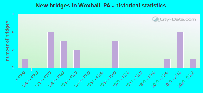
- New bridges - historical statistics
- 1Before 1900
- 41910-1919
- 31920-1929
- 21930-1939
- 31960-1969
- 12000-2009
- 42010-2019
- 12020-2022
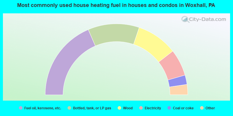
- 37.3%Fuel oil, kerosene, etc.
- 23.4%Bottled, tank, or LP gas
- 18.7%Wood
- 12.2%Electricity
- 4.3%Coal or coke
- 2.2%No fuel used
- 1.9%Utility gas
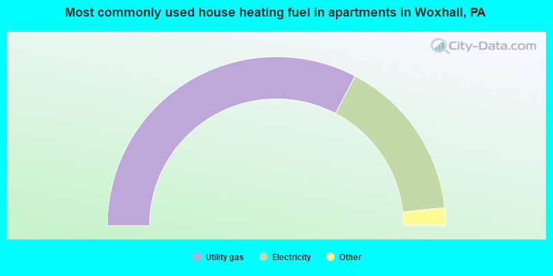
- 67.7%Utility gas
- 32.3%Electricity
Woxhall compared to Pennsylvania state average:
- Median house value above state average.
- Unemployed percentage significantly below state average.
- Black race population percentage significantly below state average.
- Foreign-born population percentage below state average.
- Renting percentage significantly below state average.
- Length of stay since moving in above state average.
- Number of rooms per house above state average.
- House age below state average.
- Number of college students below state average.