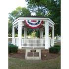
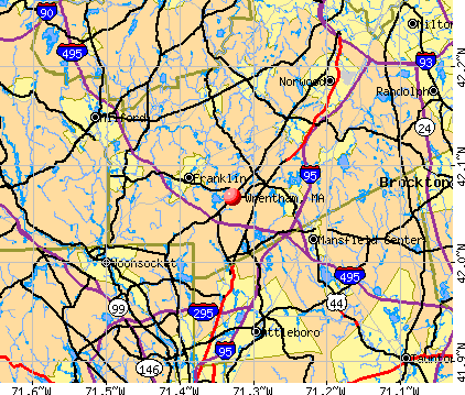
Wrentham, Massachusetts

Submit your own pictures of this town and show them to the world
- OSM Map
- General Map
- Google Map
- MSN Map
Population change since 2000: +3.8%
 |
| Males: 5,400 | |
| Females: 5,555 |
| Median resident age: | 43.6 years |
| Massachusetts median age: | 39.2 years |
Zip codes: 02093.
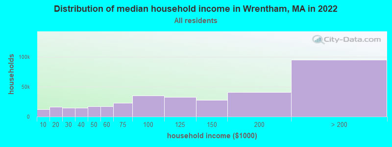
| Wrentham: | $142,681 |
| MA: | $94,488 |
Estimated per capita income in 2022: $62,720 (it was $30,792 in 2000)
Wrentham town income, earnings, and wages data
Estimated median house or condo value in 2022: $674,547 (it was $234,900 in 2000)
| Wrentham: | $674,547 |
| MA: | $534,700 |
Mean prices in 2022: all housing units: $811,449; detached houses: $851,375; townhouses or other attached units: $650,242; in 2-unit structures: $825,093; in 3-to-4-unit structures: $853,292; in 5-or-more-unit structures: $584,259; mobile homes: $91,001
Detailed information about poverty and poor residents in Wrentham, MA


Compare current foreclosures near Wrentham, MA:
| Photo | Address | Area | Beds / Baths | Price | Details |
|---|---|---|---|---|---|

|
#1
Bennett St
Wrentham, MA 02093
|
2,116 sq. feet
|
2 baths 4 beds |
show details | |

|
#2
Hillcrest Rd
Wrentham, MA 02093
|
2,062 sq. feet
|
2 baths 3 beds |
show details | |

|
#3
Oakhill Ave
Wrentham, MA 02093
|
2,628 sq. feet
|
2 baths 4 beds |
show details | |

|
#4
Lakeside Ave
Wrentham, MA 02093
|
- sq. feet
|
- baths - beds |
show details | |

|
#5
South St # 1
Wrentham, MA 02093
|
- sq. feet
|
- baths - beds |
show details | |

|
#6
Ridge Rd
Wrentham, MA 02093
|
- sq. feet
|
- baths - beds |
show details | |

|
#7
Ledgeview Way, Apt 2113
Wrentham, MA 02093
|
- sq. feet
|
- baths - beds |
show details | |

|
#8
Mount Pleasant Rd
Harrisville, RI 02830
|
1,232 sq. feet
|
1 baths 3 beds |
$449,900
|
show details |

|
#9
Loomis St
North Attleboro, MA 02760
|
2,294 sq. feet
|
2 baths 4 beds |
$700,000
|
show details |

|
#10
Stillman St
Framingham, MA 01702
|
1,122 sq. feet
|
1 baths 2 beds |
$440,000
|
show details |
| Photo | Address | Area | Beds / Baths | Price | Details |
|---|---|---|---|---|---|

|
#11
Hebron Ave
Attleboro, MA 02703
|
2,939 sq. feet
|
4 baths 6 beds |
$559,900
|
show details |

|
#12
Cook Rd
Cumberland, RI 02864
|
2,050 sq. feet
|
2 baths 4 beds |
$749,500
|
show details |

|
#13
Echo St
Brockton, MA 02301
|
1,527 sq. feet
|
2 baths 3 beds |
show details | |

|
#14
Maxwell St
Taunton, MA 02780
|
1,537 sq. feet
|
2 baths 5 beds |
show details | |

|
#15
Branch Ave
Providence, RI 02904
|
2,921 sq. feet
|
4 baths 6 beds |
show details | |

|
#16
Laurelwood Dr # No
Hopedale, MA 01747
|
1,440 sq. feet
|
1 baths 2 beds |
show details | |

|
#17
Colonel Bell Dr # 7
Brockton, MA 02301
|
886 sq. feet
|
1 baths 2 beds |
show details | |

|
#18
Glendale Ave
Uxbridge, MA 01569
|
1,302 sq. feet
|
2 baths 4 beds |
show details | |

|
#19
Cynthia Dr Apt 13
North Providence, RI 02911
|
768 sq. feet
|
1 baths 2 beds |
show details | |

|
#20
S Elm St
West Bridgewater, MA 02379
|
2,546 sq. feet
|
2 baths 4 beds |
show details |
| Photo | Address | Area | Beds / Baths | Price | Details |
|---|---|---|---|---|---|

|
#21
Oliver Ln
Hopkinton, MA 01748
|
2,002 sq. feet
|
2 baths 4 beds |
show details | |

|
#22
Mallard Dr
Medway, MA 02053
|
2,024 sq. feet
|
2 baths 5 beds |
show details | |

|
#23
Mount Hope St
North Attleboro, MA 02760
|
3,554 sq. feet
|
2 baths 4 beds |
show details | |

|
#24
Sidney Rd
Milford, MA 01757
|
1,184 sq. feet
|
1 baths 4 beds |
show details | |

|
#25
Depot St
North Attleboro, MA 02760
|
- sq. feet
|
2 baths 3 beds |
show details | |

|
#26
Zeller Ave
Plainville, MA 02762
|
888 sq. feet
|
1 baths 3 beds |
show details | |

|
#27
Grove St
Woonsocket, RI 02895
|
2,534 sq. feet
|
3 baths 6 beds |
show details | |

|
#28
Putnam Pike
Greenville, RI 02828
|
1,114 sq. feet
|
1 baths 2 beds |
show details | |

|
#29
Thacher St
Attleboro, MA 02703
|
1,040 sq. feet
|
1 baths 3 beds |
show details | |

|
#30
Bonaparte St
Providence, RI 02904
|
1,152 sq. feet
|
2 baths 4 beds |
show details |
| Photo | Address | Area | Beds / Baths | Price | Details |
|---|---|---|---|---|---|

|
#31
Oakhurst Rd
Hopkinton, MA 01748
|
1,008 sq. feet
|
1 baths 2 beds |
show details | |

|
#32
E Lakeview Dr
Providence, RI 02904
|
1,584 sq. feet
|
2 baths 3 beds |
show details | |

|
#33
Picard Ter
Framingham, MA 01702
|
2,484 sq. feet
|
3 baths 6 beds |
show details | |

|
#34
Meadow View Blvd
Providence, RI 02904
|
1,144 sq. feet
|
2 baths 3 beds |
show details | |

|
#35
Log Rd
Smithfield, RI 02917
|
1,276 sq. feet
|
1 baths 3 beds |
show details | |

|
#36
Nickerson Dr
Stoughton, MA 02072
|
2,232 sq. feet
|
2 baths 3 beds |
show details | |

|
#37
Healey Ter
Brockton, MA 02301
|
1,128 sq. feet
|
1 baths 3 beds |
show details | |

|
#38
Village St # 73
South Easton, MA 02375
|
1,254 sq. feet
|
1 baths 2 beds |
show details | |

|
#39
Coronation Dr
Dedham, MA 02026
|
1,581 sq. feet
|
1 baths 3 beds |
show details | |

|
#40
Twins Ln
Providence, RI 02904
|
1,248 sq. feet
|
2 baths 3 beds |
show details |
| Photo | Address | Area | Beds / Baths | Price | Details |
|---|---|---|---|---|---|

|
#41
Rosner Ave
Providence, RI 02904
|
1,236 sq. feet
|
1 baths 3 beds |
show details | |

|
#42
Fatima Dr
Ashland, MA 01721
|
2,708 sq. feet
|
2 baths 4 beds |
show details | |

|
#43
East St
Natick, MA 01760
|
882 sq. feet
|
1 baths 2 beds |
show details | |

|
#44
Church St
Hopkinton, MA 01748
|
5,497 sq. feet
|
2 baths 4 beds |
show details | |

|
#45
Glebe St
Taunton, MA 02780
|
2,826 sq. feet
|
2 baths 4 beds |
show details | |

|
#46
Hawthorne Pl # 12
Providence, RI 02904
|
1,280 sq. feet
|
1 baths 2 beds |
show details | |

|
#47
Ryan Cir
Taunton, MA 02780
|
1,992 sq. feet
|
2 baths 3 beds |
show details | |

|
#48
Mulhall Dr
Ashland, MA 01721
|
1,056 sq. feet
|
1 baths 3 beds |
show details | |

|
#49
9th St
Providence, RI 02906
|
2,652 sq. feet
|
2 baths 4 beds |
show details | |

|
Check over 1 million property listings on Foreclosure.com!
|
browse all offers | |||

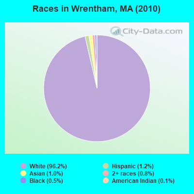
- 10,54196.2%White alone
- 1331.2%Hispanic
- 1121.0%Asian alone
- 870.8%Two or more races
- 600.5%Black alone
- 160.1%American Indian alone
- 60.05%Other race alone
Races in Wrentham detailed stats: ancestries, foreign born residents, place of birth
According to our research of Massachusetts and other state lists, there were 2 registered sex offenders living in Wrentham, Massachusetts as of April 18, 2024.
The ratio of all residents to sex offenders in Wrentham is 5,478 to 1.
The ratio of registered sex offenders to all residents in this city is much lower than the state average.
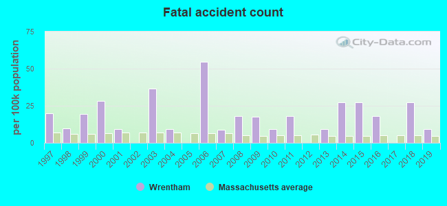
Type |
2009 |
2010 |
2011 |
2012 |
2013 |
2014 |
2015 |
2016 |
2017 |
2018 |
2019 |
2020 |
2021 |
2022 |
|---|---|---|---|---|---|---|---|---|---|---|---|---|---|---|
| Murders (per 100,000) | 0 (0.0) | 0 (0.0) | 0 (0.0) | 0 (0.0) | 0 (0.0) | 0 (0.0) | 0 (0.0) | 0 (0.0) | 0 (0.0) | 0 (0.0) | 0 (0.0) | 0 (0.0) | 0 (0.0) | 0 (0.0) |
| Rapes (per 100,000) | 2 (17.6) | 0 (0.0) | 2 (18.1) | 1 (9.0) | 1 (8.9) | 1 (8.8) | 1 (8.7) | 0 (0.0) | 0 (0.0) | 2 (16.7) | 2 (16.7) | 1 (8.3) | 1 (8.1) | 1 (8.1) |
| Robberies (per 100,000) | 0 (0.0) | 0 (0.0) | 1 (9.1) | 1 (9.0) | 0 (0.0) | 0 (0.0) | 2 (17.3) | 1 (8.6) | 0 (0.0) | 0 (0.0) | 0 (0.0) | 0 (0.0) | 1 (8.1) | 0 (0.0) |
| Assaults (per 100,000) | 1 (8.8) | 5 (45.6) | 1 (9.1) | 7 (62.9) | 7 (62.5) | 9 (79.1) | 5 (43.3) | 4 (34.4) | 8 (67.6) | 3 (25.1) | 2 (16.7) | 8 (66.1) | 20 (162.2) | 3 (24.3) |
| Burglaries (per 100,000) | 54 (475.4) | 49 (447.3) | 9 (81.7) | 10 (89.9) | 48 (428.8) | 25 (219.8) | 25 (216.6) | 9 (77.5) | 14 (118.3) | 11 (92.0) | 18 (150.1) | 5 (41.3) | 9 (73.0) | 17 (137.7) |
| Thefts (per 100,000) | 128 (1,127) | 175 (1,597) | 191 (1,733) | 84 (755.1) | 206 (1,840) | 171 (1,503) | 191 (1,655) | 198 (1,705) | 183 (1,546) | 195 (1,632) | 153 (1,276) | 61 (503.6) | 76 (616.2) | 183 (1,483) |
| Auto thefts (per 100,000) | 6 (52.8) | 4 (36.5) | 0 (0.0) | 6 (53.9) | 8 (71.5) | 10 (87.9) | 2 (17.3) | 8 (68.9) | 9 (76.0) | 12 (100.4) | 7 (58.4) | 1 (8.3) | 2 (16.2) | 2 (16.2) |
| Arson (per 100,000) | 1 (8.8) | 0 (0.0) | 0 (0.0) | 0 (0.0) | 0 (0.0) | 3 (26.4) | 0 (0.0) | 0 (0.0) | 0 (0.0) | 0 (0.0) | 0 (0.0) | 0 (0.0) | 0 (0.0) | 0 (0.0) |
| City-Data.com crime index | 98.4 | 107.3 | 94.1 | 63.3 | 129.0 | 105.4 | 103.5 | 88.6 | 89.7 | 98.1 | 82.9 | 43.5 | 72.4 | 81.6 |
The City-Data.com crime index weighs serious crimes and violent crimes more heavily. Higher means more crime, U.S. average is 246.1. It adjusts for the number of visitors and daily workers commuting into cities.
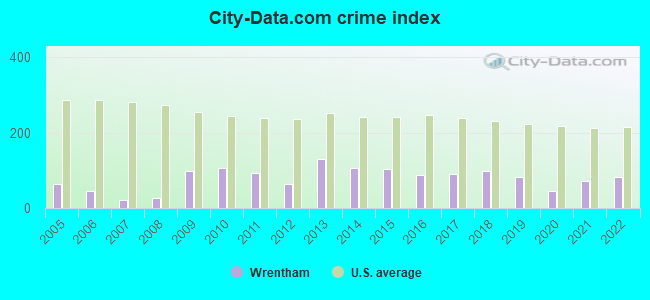
Crime rate in Wrentham detailed stats: murders, rapes, robberies, assaults, burglaries, thefts, arson
Full-time law enforcement employees in 2021, including police officers: 23 (22 officers - 22 male; 0 female).
| Officers per 1,000 residents here: | 1.78 |
| Massachusetts average: | 2.53 |
 Recent articles from our blog. Our writers, many of them Ph.D. graduates or candidates, create easy-to-read articles on a wide variety of topics.


 | Will people commute from Natick to Wrentham for work? (2 replies) |
| Gov Declares "State of Emergency" for Migrant Crisis (1384 replies) |
| 2022 Real Estate Observations (1122 replies) |
| Wrentham Outlet Shopping Safe? (8 replies) |
| Charlie Baker Will Not Seek Reelection in 2022 (280 replies) |
| What's going on in Wrentham?! (29 replies) |
Latest news from Wrentham, MA collected exclusively by city-data.com from local newspapers, TV, and radio stations
Wrentham, MA City Guides:
Ancestries: Irish (34.9%), Italian (16.8%), English (13.6%), French Canadian (8.6%), German (8.2%), French (5.3%).
Current Local Time: EST time zone
Incorporated in 1673
Elevation: 253 feet
Land area: 22.2 square miles.
Population density: 494 people per square mile (low).
393 residents are foreign born (1.6% Europe, 0.7% North America, 0.6% Asia, 0.5% Africa).
| This town: | 3.7% |
| Massachusetts: | 12.2% |
| Wrentham town: | 1.3% ($2,970) |
| Massachusetts: | 1.3% ($2,336) |
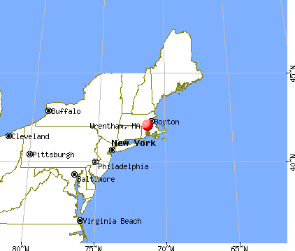
Nearest city with pop. 50,000+: Pawtucket, RI  (12.8 miles , pop. 72,958).
Nearest city with pop. 200,000+: Boston, MA (22.4 miles , pop. 589,141).
Nearest city with pop. 1,000,000+: Bronx, NY (155.6 miles , pop. 1,332,650).
Nearest cities:
), ), ), ), )Latitude: 42.06 N, Longitude: 71.35 W
Area codes: 508, 774
Wrentham, Massachusetts accommodation & food services, waste management - Economy and Business Data
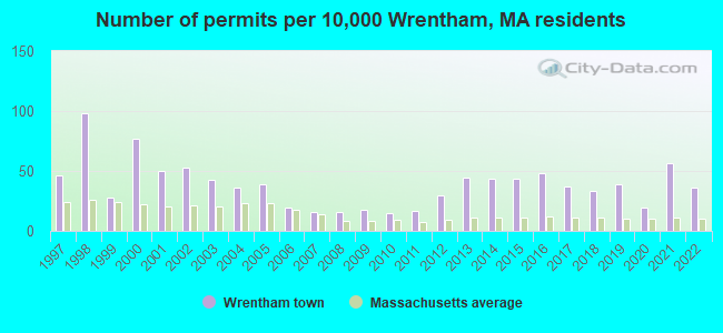
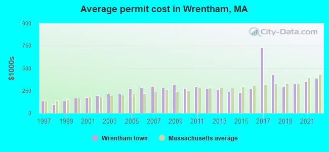
Single-family new house construction building permits:
- 2022: 38 buildings, average cost: $390,700
- 2021: 60 buildings, average cost: $350,400
- 2020: 21 buildings, average cost: $324,800
- 2019: 41 buildings, average cost: $291,100
- 2018: 35 buildings, average cost: $428,200
- 2017: 39 buildings, average cost: $727,800
- 2016: 51 buildings, average cost: $270,900
- 2015: 46 buildings, average cost: $229,800
- 2014: 46 buildings, average cost: $237,700
- 2013: 47 buildings, average cost: $257,500
- 2012: 31 buildings, average cost: $272,000
- 2011: 18 buildings, average cost: $293,400
- 2010: 16 buildings, average cost: $276,500
- 2009: 19 buildings, average cost: $319,900
- 2008: 17 buildings, average cost: $284,400
- 2007: 17 buildings, average cost: $301,100
- 2006: 21 buildings, average cost: $282,400
- 2005: 41 buildings, average cost: $279,300
- 2004: 38 buildings, average cost: $214,300
- 2003: 45 buildings, average cost: $211,900
- 2002: 56 buildings, average cost: $200,400
- 2001: 53 buildings, average cost: $173,300
- 2000: 81 buildings, average cost: $167,200
- 1999: 29 buildings, average cost: $135,600
- 1998: 104 buildings, average cost: $97,600
- 1997: 49 buildings, average cost: $133,700
| Here: | 2.8% |
| Massachusetts: | 3.5% |
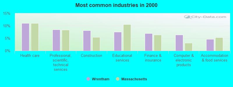
- Health care (11.0%)
- Professional, scientific, technical services (8.5%)
- Construction (8.1%)
- Educational services (7.6%)
- Finance & insurance (7.0%)
- Computer & electronic products (6.4%)
- Accommodation & food services (4.6%)
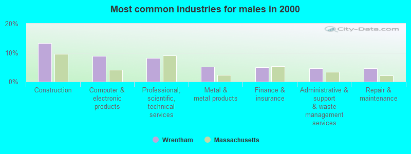
- Construction (13.2%)
- Computer & electronic products (8.9%)
- Professional, scientific, technical services (8.2%)
- Metal & metal products (5.1%)
- Finance & insurance (5.0%)
- Administrative & support & waste management services (4.7%)
- Repair & maintenance (4.5%)
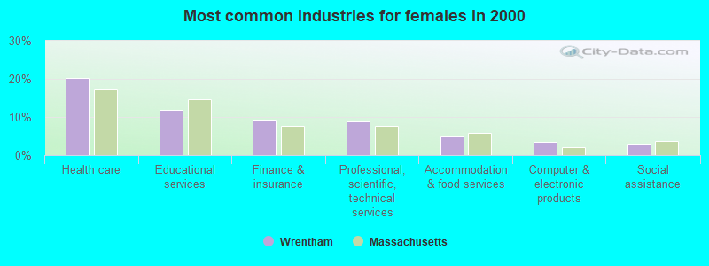
- Health care (20.1%)
- Educational services (11.8%)
- Finance & insurance (9.3%)
- Professional, scientific, technical services (8.8%)
- Accommodation & food services (5.1%)
- Computer & electronic products (3.4%)
- Social assistance (2.9%)
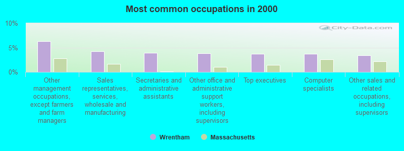
- Other management occupations, except farmers and farm managers (6.3%)
- Sales representatives, services, wholesale and manufacturing (4.2%)
- Secretaries and administrative assistants (3.9%)
- Other office and administrative support workers, including supervisors (3.8%)
- Top executives (3.7%)
- Computer specialists (3.7%)
- Other sales and related occupations, including supervisors (3.4%)
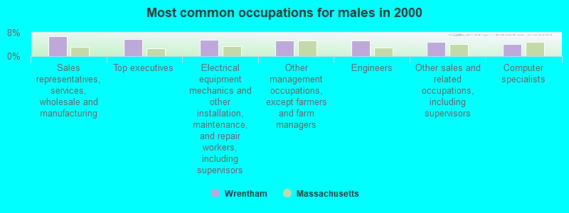
- Sales representatives, services, wholesale and manufacturing (6.8%)
- Top executives (5.8%)
- Electrical equipment mechanics and other installation, maintenance, and repair workers, including supervisors (5.6%)
- Other management occupations, except farmers and farm managers (5.4%)
- Engineers (5.3%)
- Other sales and related occupations, including supervisors (4.8%)
- Computer specialists (4.0%)

- Secretaries and administrative assistants (8.4%)
- Other management occupations, except farmers and farm managers (7.3%)
- Other office and administrative support workers, including supervisors (6.8%)
- Health technologists and technicians (6.1%)
- Registered nurses (5.6%)
- Retail sales workers, except cashiers (4.1%)
- Preschool, kindergarten, elementary, and middle school teachers (3.6%)
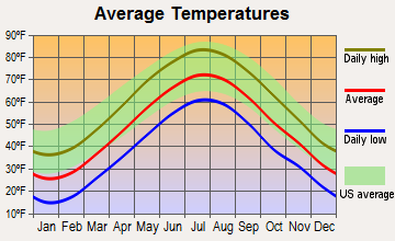
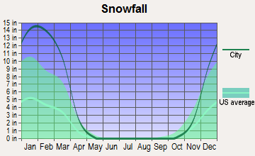
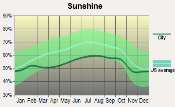
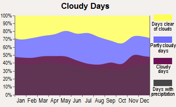
Average climate in Wrentham, Massachusetts
Based on data reported by over 4,000 weather stations


(lower is better)
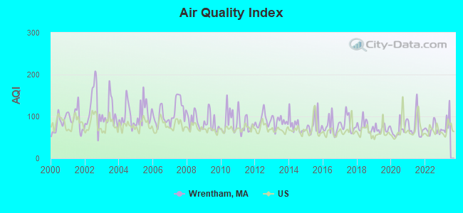
Air Quality Index (AQI) level in 2022 was 69.6. This is about average.
| City: | 69.6 |
| U.S.: | 72.6 |
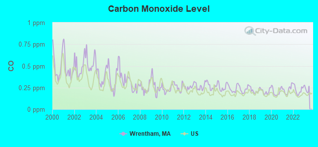
Carbon Monoxide (CO) [ppm] level in 2022 was 0.224. This is about average. Closest monitor was 12.8 miles away from the city center.
| City: | 0.224 |
| U.S.: | 0.251 |
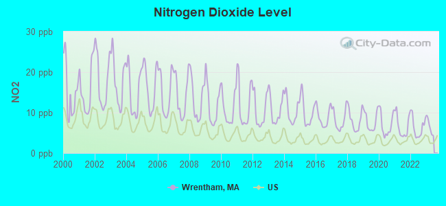
Nitrogen Dioxide (NO2) [ppb] level in 2022 was 6.40. This is worse than average. Closest monitor was 8.9 miles away from the city center.
| City: | 6.40 |
| U.S.: | 5.11 |
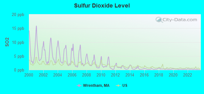
Sulfur Dioxide (SO2) [ppb] level in 2022 was 0.234. This is significantly better than average. Closest monitor was 8.9 miles away from the city center.
| City: | 0.234 |
| U.S.: | 1.515 |
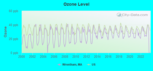
Ozone [ppb] level in 2022 was 29.9. This is about average. Closest monitor was 9.3 miles away from the city center.
| City: | 29.9 |
| U.S.: | 33.3 |
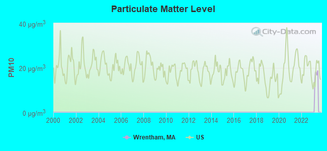
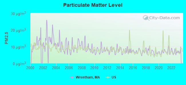
Particulate Matter (PM2.5) [µg/m3] level in 2022 was 6.73. This is better than average. Closest monitor was 12.6 miles away from the city center.
| City: | 6.73 |
| U.S.: | 8.11 |
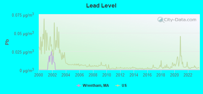
Lead (Pb) [µg/m3] level in 2001 was 0.0153. This is significantly worse than average. Closest monitor was 12.9 miles away from the city center.
| City: | 0.0153 |
| U.S.: | 0.0093 |
Tornado activity:
Wrentham-area historical tornado activity is near Massachusetts state average. It is 42% smaller than the overall U.S. average.
On 6/9/1953, a category F4 (max. wind speeds 207-260 mph) tornado 18.9 miles away from the Wrentham town center killed 90 people and injured 1228 people and caused between $50,000,000 and $500,000,000 in damages.
On 6/9/1953, a category F3 (max. wind speeds 158-206 mph) tornado 7.5 miles away from the town center injured 17 people and caused between $500,000 and $5,000,000 in damages.
Earthquake activity:
Wrentham-area historical earthquake activity is significantly above Massachusetts state average. It is 73% smaller than the overall U.S. average.On 10/7/1983 at 10:18:46, a magnitude 5.3 (5.1 MB, 5.3 LG, 5.1 ML, Class: Moderate, Intensity: VI - VII) earthquake occurred 200.3 miles away from Wrentham center
On 4/20/2002 at 10:50:47, a magnitude 5.3 (5.3 ML, Depth: 3.0 mi) earthquake occurred 206.8 miles away from the city center
On 1/19/1982 at 00:14:42, a magnitude 4.7 (4.5 MB, 4.7 MD, 4.5 LG, Class: Light, Intensity: IV - V) earthquake occurred 100.5 miles away from Wrentham center
On 4/20/2002 at 10:50:47, a magnitude 5.2 (5.2 MB, 4.2 MS, 5.2 MW, 5.0 MW) earthquake occurred 206.0 miles away from the city center
On 10/16/2012 at 23:12:25, a magnitude 4.7 (4.7 ML, Depth: 10.0 mi) earthquake occurred 112.0 miles away from Wrentham center
On 8/22/1992 at 12:20:32, a magnitude 4.8 (4.8 MB, 3.8 MS, 4.7 LG, Depth: 6.2 mi) earthquake occurred 211.3 miles away from the city center
Magnitude types: regional Lg-wave magnitude (LG), body-wave magnitude (MB), duration magnitude (MD), local magnitude (ML), surface-wave magnitude (MS), moment magnitude (MW)
Natural disasters:
The number of natural disasters in Norfolk County (31) is a lot greater than the US average (15).Major Disasters (Presidential) Declared: 18
Emergencies Declared: 13
Causes of natural disasters: Floods: 12, Storms: 10, Hurricanes: 6, Snowstorms: 5, Snows: 3, Winter Storms: 3, Blizzards: 2, Explosion: 1, Heavy Rain: 1, Snowfall: 1, Tropical Storm: 1, Water Main Break: 1, Wind: 1 (Note: some incidents may be assigned to more than one category).

Hospitals and medical centers in Wrentham:
Amtrak stations near Wrentham:
- 15 miles: ROUTE 128 (WESTWOOD, UNIVERSITY AVE. & RTE. 128) . Services: ticket office, enclosed waiting area, public restrooms, public payphones, vending machines, paid short-term parking, taxi stand, public transit connection.
- 16 miles: FRAMINGHAM (443 WAVERLY ST.) . Services: public payphones, snack bar, paid short-term parking, taxi stand, public transit connection.
- 17 miles: PROVIDENCE (100 GASPEE ST.) . Services: ticket office, fully wheelchair accessible, enclosed waiting area, public restrooms, public payphones, snack bar, ATM, paid short-term parking, paid long-term parking, call for car rental service, taxi stand, public transit connection.
Colleges/universities with over 2000 students nearest to Wrentham:
- Stonehill College (about 14 miles; Easton, MA; Full-time enrollment: 2,563)
- Bryant University (about 14 miles; Smithfield, RI; FT enrollment: 3,440)
- Providence College (about 16 miles; Providence, RI; FT enrollment: 4,312)
- Rhode Island College (about 17 miles; Providence, RI; FT enrollment: 7,189)
- Wellesley College (about 17 miles; Wellesley, MA; FT enrollment: 2,658)
- Brown University (about 17 miles; Providence, RI; FT enrollment: 8,458)
- Rhode Island School of Design (about 17 miles; Providence, RI; FT enrollment: 2,714)
Public high school in Wrentham:
- KING PHILIP REGIONAL HIGH (Students: 1,199, Location: 201 FRANKLIN STREET, Grades: 9-12)
Public elementary/middle schools in Wrentham:
- DELANEY (Students: 737, Location: 120 TAUNTON STREET, Grades: PK-3)
- CHARLES E RODERICK (Students: 490, Location: 120 TAUNTON STREET, Grades: 4-6)
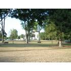
Points of interest:
Notable locations in Wrentham: Wrentham Fire Department Station 2 (A), Wrentham Fire Department Station 1 Headquarters (B), Fiske Public Library (C). Display/hide their locations on the map
Churches in Wrentham include: Trinity Episcopal Church (A), Sheldonville Baptist Church (B), Original Congregational Church (C), The Church of Jesus Christ of Latter Day Saints (D). Display/hide their locations on the map
Cemeteries: Burnt Swamp Cemetery (1), Center Cemetery (2), Sheldonville Cemetery (3). Display/hide their locations on the map
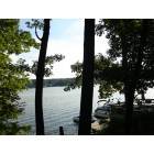
Lakes, reservoirs, and swamps: Lake Archer (A), Crocker Pond (B), Mirror Lake (C), Trout Pond (D), Lake Pearl (E), Stony Brook Pond (F), Hawes Pond (G), Hales Pond (H). Display/hide their locations on the map
Streams, rivers, and creeks: Uncas Brook (A). Display/hide its location on the map
Tourist attraction: Absolute Backorder Service (Cultural Attractions- Events- & Facilities; 475 Washington Street) (1). Display/hide its approximate location on the map
Hotel: Arbor Inn Motel (900 Washington St) (1). Display/hide its approximate location on the map
Court: Mass Commonwealth - District Court-Wrentham Division (60 East Street) (1). Display/hide its approximate location on the map
Birthplace of: Cyrus B. Comstock - Major general in the Army during the Civil War, Garth Snow - NHL player (New York Islanders, born: Jul 28, 1969), George O. Brastow - Politician, Sarah Elizabeth Forbush Downs - Women writer.
Drinking water stations with addresses in Wrentham and their reported violations in the past:
MOUNT ST MARYS ABBEY (Population served: 60, Groundwater):Past health violations:Past monitoring violations:
- MCL, Monthly (TCR) - In SEP-2011, Contaminant: Coliform. Follow-up actions: St AO (w/o penalty) issued (NOV-29-2011), St Compliance achieved (NOV-29-2011)
- MCL, Monthly (TCR) - In OCT-2007, Contaminant: Coliform. Follow-up actions: St AO (w/o penalty) issued (JUN-27-2008), St Compliance achieved (JUL-23-2008)
- One routine major monitoring violation
- 2 minor monitoring violations
- 13 regular monitoring violations
| This town: | 2.8 people |
| Massachusetts: | 2.5 people |
| This town: | 76.6% |
| Whole state: | 63.0% |
| This town: | 4.8% |
| Whole state: | 7.0% |
Likely homosexual households (counted as self-reported same-sex unmarried-partner households)
- Lesbian couples: 0.5% of all households
- Gay men: 0.2% of all households
| This town: | 3.9% |
| Whole state: | 9.3% |
| This town: | 1.6% |
| Whole state: | 4.4% |
People in group quarters in Wrentham in 2010:
- 279 people in state prisons
- 215 people in nursing facilities/skilled-nursing facilities
- 51 people in other noninstitutional facilities
- 4 people in residential treatment centers for adults
People in group quarters in Wrentham in 2000:
- 348 people in schools, hospitals, or wards for the intellectually disabled
- 306 people in nursing homes
- 49 people in religious group quarters
- 27 people in other noninstitutional group quarters
- 8 people in homes for the physically handicapped
Banks with branches in Wrentham (2011 data):
- Wrentham Co-operative Bank: South Street Branch at 1005 South Street, branch established on 2003/01/13; Wrentham Co-Operative Bank at 102 South Street, branch established on 1901/01/01. Info updated 2008/07/10: Bank assets: $108.3 mil, Deposits: $94.3 mil, local headquarters, positive income, 2 total offices
- TD Bank, National Association: Wrentham Branch at 127 South Street, branch established on 1977/09/09. Info updated 2010/10/04: Bank assets: $188,912.6 mil, Deposits: $153,149.8 mil, headquarters in Wilmington, DE, positive income, 1314 total offices, Holding Company: Toronto-Dominion Bank, The
For population 15 years and over in Wrentham:
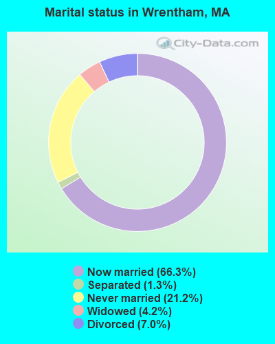
- Never married: 21.2%
- Now married: 66.3%
- Separated: 1.3%
- Widowed: 4.2%
- Divorced: 7.0%
For population 25 years and over in Wrentham:
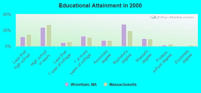
- High school or higher: 87.9%
- Bachelor's degree or higher: 39.1%
- Graduate or professional degree: 11.7%
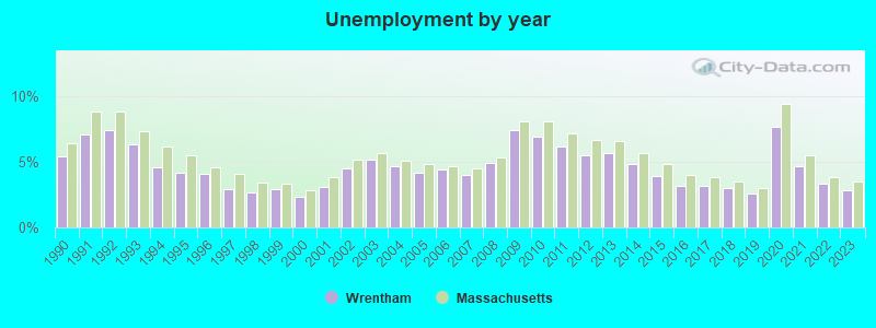
- Unemployed: 2.5%
- Mean travel time to work (commute): 30.5 minutes
| Here: | 11.6 |
| Massachusetts average: | 13.1 |
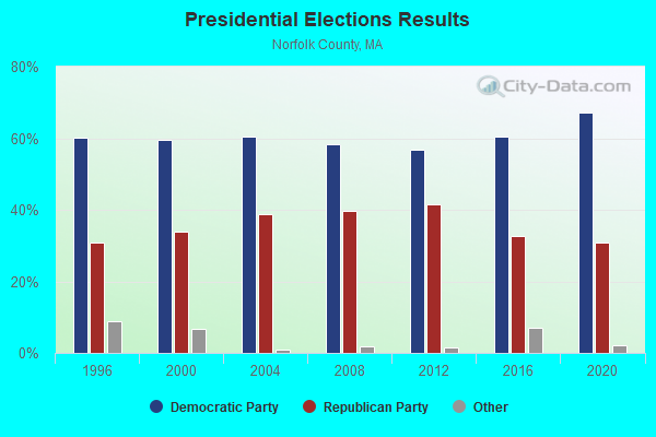
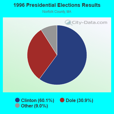
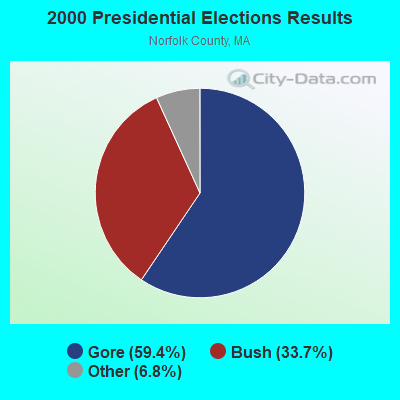
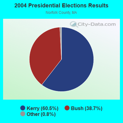
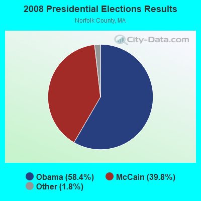
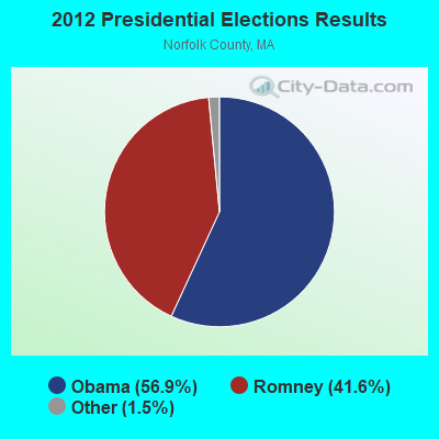

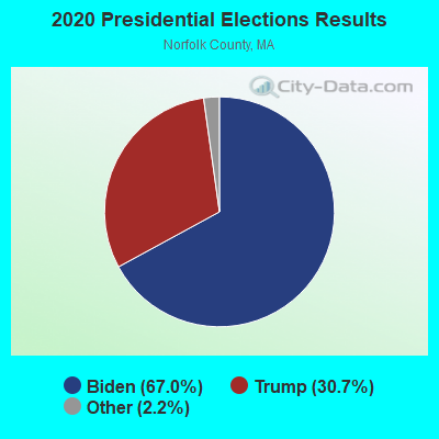
Graphs represent county-level data. Detailed 2008 Election Results
Religion statistics for Wrentham, MA (based on Norfolk County data)
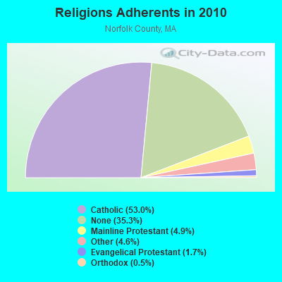
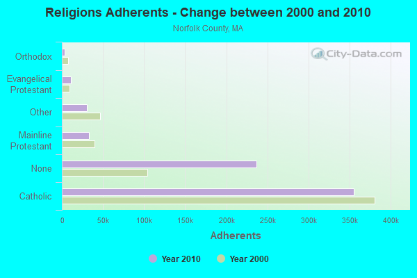
| Religion | Adherents | Congregations |
|---|---|---|
| Catholic | 355,321 | 52 |
| Mainline Protestant | 33,086 | 115 |
| Other | 30,593 | 75 |
| Evangelical Protestant | 11,323 | 89 |
| Orthodox | 3,539 | 9 |
| None | 236,988 | - |
Food Environment Statistics:
| Norfolk County: | 1.65 / 10,000 pop. |
| Massachusetts: | 1.98 / 10,000 pop. |
| Norfolk County: | 0.09 / 10,000 pop. |
| Massachusetts: | 0.05 / 10,000 pop. |
| This county: | 2.04 / 10,000 pop. |
| Massachusetts: | 2.22 / 10,000 pop. |
| Norfolk County: | 1.57 / 10,000 pop. |
| Massachusetts: | 1.77 / 10,000 pop. |
| Norfolk County: | 8.48 / 10,000 pop. |
| State: | 8.76 / 10,000 pop. |
| Here: | 7.1% |
| Massachusetts: | 8.1% |
| Here: | 19.1% |
| State: | 22.5% |
| Norfolk County: | 12.9% |
| State: | 16.5% |
8.01% of this county's 2021 resident taxpayers lived in other counties in 2020 ($110,572 average adjusted gross income)
| Here: | 8.01% |
| Massachusetts average: | 6.35% |
0.01% of residents moved from foreign countries ($78 average AGI)
Norfolk County: 0.01% Massachusetts average: 0.01%
Top counties from which taxpayers relocated into this county between 2020 and 2021:
| from Suffolk County, MA | |
| from Middlesex County, MA | |
| from Plymouth County, MA |
8.55% of this county's 2020 resident taxpayers moved to other counties in 2021 ($128,358 average adjusted gross income)
| Here: | 8.55% |
| Massachusetts average: | 7.18% |
0.01% of residents moved to foreign countries ($348 average AGI)
Norfolk County: 0.01% Massachusetts average: 0.02%
Top counties to which taxpayers relocated from this county between 2020 and 2021:
| to Suffolk County, MA | |
| to Middlesex County, MA | |
| to Plymouth County, MA |
| Businesses in Wrentham, MA | ||||
| Name | Count | Name | Count | |
|---|---|---|---|---|
| ALDO | 1 | IZOD | 1 | |
| Aeropostale | 1 | J. Jill | 1 | |
| Aerosoles | 1 | J.Crew | 2 | |
| American Eagle Outfitters | 1 | Jones New York | 1 | |
| Ann Taylor | 2 | Journeys | 1 | |
| Banana Republic | 1 | Juicy Couture | 1 | |
| Brooks Brothers | 1 | Justice | 1 | |
| Brookstone | 1 | Lane Bryant | 1 | |
| Casual Male XL | 1 | Levi Strauss & Co. | 1 | |
| Chico's | 1 | Motherhood Maternity | 1 | |
| Clarks | 1 | New Balance | 1 | |
| Cracker Barrel | 1 | Nike | 5 | |
| DressBarn | 1 | Pac Sun | 1 | |
| Dressbarn | 1 | Ruby Tuesday | 1 | |
| Dunkin Donuts | 2 | Rue21 | 1 | |
| Eddie Bauer | 1 | Skechers USA | 1 | |
| Famous Footwear | 1 | Talbots | 1 | |
| FedEx | 2 | UPS | 2 | |
| Gap | 1 | Vans | 2 | |
| Gymboree | 1 | |||
Strongest AM radio stations in Wrentham:
- WEEI (850 AM; 50 kW; BOSTON, MA; Owner: ENTERCOM BOSTON LICENSE, LLC)
- WALE (990 AM; 50 kW; GREENVILLE, RI; Owner: NORTH AMERICAN BROADCASTING CO., INC.)
- WKOX (1200 AM; 50 kW; FRAMINGHAM, MA; Owner: CAPSTAR TX LIMITED PARTNERSHIP)
- WAMG (890 AM; 25 kW; DEDHAM, MA; Owner: MEGA COMMUNICATIONS OF DEDHAM LICENSEE, LLC)
- WBIX (1060 AM; 40 kW; NATICK, MA; Owner: LANGER BROADCASTING CORPORATION)
- WDIS (1170 AM; daytime; 1 kW; NORFOLK, MA; Owner: DISCUSSION RADIO, INCORPORATED)
- WARL (1320 AM; 5 kW; ATTLEBORO, MA; Owner: THE ADD RADIO GROUP, INC.)
- WRKO (680 AM; 50 kW; BOSTON, MA; Owner: ENTERCOM BOSTON LICENSE, LLC)
- WDDZ (550 AM; 5 kW; PAWTUCKET, RI; Owner: ABC, INC.)
- WWZN (1510 AM; 50 kW; BOSTON, MA; Owner: ROSE CITY RADIO CORPORATION)
- WBZ (1030 AM; 50 kW; BOSTON, MA; Owner: INFINITY BROADCASTING OPERATIONS, INC.)
- WCRN (830 AM; 50 kW; WORCESTER, MA; Owner: CARTER BROADCASTING CORPORATION)
- WRCA (1330 AM; 25 kW; WALTHAM, MA; Owner: WRCA LICENSE, LLC)
Strongest FM radio stations in Wrentham:
- WGAO (88.3 FM; FRANKLIN, MA; Owner: DEAN COLLEGE)
- WWBB (101.5 FM; PROVIDENCE, RI; Owner: CLEAR CHANNEL BROADCASTING LICENSES, INC.)
- WBMX (98.5 FM; BOSTON, MA; Owner: INFINITY RADIO OPERATIONS INC.)
- WBOS (92.9 FM; BROOKLINE, MA; Owner: GREATER BOSTON RADIO, INC.)
- WJMN (94.5 FM; BOSTON, MA; Owner: AMFM RADIO LICENSES, L.L.C.)
- WCRB (102.5 FM; WALTHAM, MA; Owner: CHARLES RIVER BROADCASTING WCRB LICE)
- WTKK (96.9 FM; BOSTON, MA; Owner: GREATER BOSTON RADIO, INC.)
- WROR-FM (105.7 FM; FRAMINGHAM, MA; Owner: GREATER BOSTON RADIO, INC.)
- WGBH (89.7 FM; BOSTON, MA; Owner: WGBH EDUCATIONAL FOUNDATION)
- WBUR-FM (90.9 FM; BOSTON, MA; Owner: TRUSTEES OF BOSTON UNIVERSITY)
- WWKX (106.3 FM; WOONSOCKET, RI; Owner: AAA ENTERTAINMENT LICENSING LLC)
- WSNE-FM (93.3 FM; TAUNTON, MA; Owner: CAPSTAR TX LIMITED PARTNERSHIP)
- WODS (103.3 FM; BOSTON, MA; Owner: INFINITY BROADCASTING OPERATIONS, INC.)
- WXKS-FM (107.9 FM; MEDFORD, MA; Owner: AMFM RADIO LICENSES, L.L.C.)
- WMJX (106.7 FM; BOSTON, MA; Owner: GREATER BOSTON RADIO, INC.)
- WBOT (97.7 FM; BROCKTON, MA; Owner: RADIO ONE LICENSES, LLC)
- WBRU (95.5 FM; PROVIDENCE, RI; Owner: BROWN BROADCASTING SERVICE, INC.)
- WHJY (94.1 FM; PROVIDENCE, RI; Owner: CAPSTAR TX LIMITED PARTNERSHIP)
- WBCN (104.1 FM; BOSTON, MA; Owner: HEMISPHERE BROADCASTING CORPORATION)
- WZLX (100.7 FM; BOSTON, MA; Owner: INFINITY BROADCASTING CORPORATION OF BOSTON)
TV broadcast stations around Wrentham:
- WCVB-TV (Channel 5; BOSTON, MA; Owner: WCVB HEARST-ARGYLE TV, INC.)
- WGBH-TV (Channel 2; BOSTON, MA; Owner: WGBH EDUCATIONAL FOUNDATION)
- WPRI-TV (Channel 12; PROVIDENCE, RI; Owner: TVL BROADCASTING OF RHODE ISLAND, LLC)
- WNAC-TV (Channel 64; PROVIDENCE, RI; Owner: WNAC, LLC)
- WMFP (Channel 62; LAWRENCE, MA; Owner: WSAH LICENSE, INC.)
- WHDH-TV (Channel 7; BOSTON, MA; Owner: WHDH-TV)
- WSBK-TV (Channel 38; BOSTON, MA; Owner: VIACOM INC.)
- WWDP (Channel 46; NORWELL, MA; Owner: NORWELL TELEVISION, LLC)
- WLVI-TV (Channel 56; CAMBRIDGE, MA; Owner: WLVI, INC.)
- WLNE-TV (Channel 6; NEW BEDFORD, MA; Owner: FREEDOM BROADCASTING OF SOUTHERN NEW ENGLAND, INC.)
- WBZ-TV (Channel 4; BOSTON, MA; Owner: VIACOM INC.)
- WGBX-TV (Channel 44; BOSTON, MA; Owner: WGBH EDUCATIONAL FOUNDATION)
- WJAR (Channel 10; PROVIDENCE, RI; Owner: OUTLET BROADCASTING, INC.)
- WFXT (Channel 25; BOSTON, MA; Owner: FOX TELEVISION STATIONS INC.)
- WSBE-TV (Channel 36; PROVIDENCE, RI; Owner: RHODE ISLAND PUBLIC TELECOM. AUTHORITY)
- WUTF (Channel 66; MARLBOROUGH, MA; Owner: TELEFUTURA BOSTON LLC)
- W40BO (Channel 40; BOSTON, MA; Owner: PAXSON COMMUNICATIONS LPTV, INC.)
- WUNI (Channel 27; WORCESTER, MA; Owner: ENTRAVISION HOLDINGS, LLC)
- WBPX (Channel 68; BOSTON, MA; Owner: PAXSON BOSTON-68 LICENSE, INC.)
- WPXQ (Channel 69; BLOCK ISLAND, RI; Owner: OCEAN STATE TELEVISION, L.L.C.)
- WTMU-LP (Channel 32; BOSTON, MA; Owner: ZGS BOSTON, INC.)
- WCEA-LP (Channel 58; BOSTON, MA; Owner: CHANNEL 19 TV CORPORATION)
- WLWC (Channel 28; NEW BEDFORD, MA; Owner: C-28 FCC LICENSEE SUBSIDIARY, LLC)
- WRIW-LP (Channel 50; PROVIDENCE, RI; Owner: ZGS PROVIDENCE, INC.)
- WYDN (Channel 48; WORCESTER, MA; Owner: EDUCATIONAL PUBLIC TV CORPORATION)
- National Bridge Inventory (NBI) Statistics
- 13Number of bridges
- 102ft / 30.8mTotal length
- $29,940,000Total costs
- 384,071Total average daily traffic
- 14,603Total average daily truck traffic
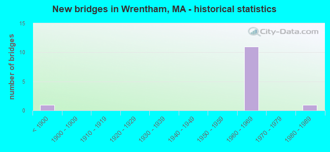
- New bridges - historical statistics
- 1Before 1900
- 111960-1969
- 11980-1989
FCC Registered Cell Phone Towers:
1 (See the full list of FCC Registered Cell Phone Towers in Wrentham)FCC Registered Antenna Towers:
12 (See the full list of FCC Registered Antenna Towers)FCC Registered Broadcast Land Mobile Towers:
15 (See the full list of FCC Registered Broadcast Land Mobile Towers in Wrentham, MA)FCC Registered Microwave Towers:
17 (See the full list of FCC Registered Microwave Towers in this town)FCC Registered Amateur Radio Licenses:
48 (See the full list of FCC Registered Amateur Radio Licenses in Wrentham)FAA Registered Aircraft:
2- Aircraft: CESSNA 150F (Category: Land, Seats: 2, Weight: Up to 12,499 Pounds, Speed: 90 mph), Engine: CONT MOTOR 0-200 SERIES (100 HP) (Reciprocating)
N-Number: 8224F, N8224F, N-8224F, Serial Number: 15064324, Year manufactured: 1966, Airworthiness Date: 06/10/1966, Certificate Issue Date: 07/09/2018
Registrant (Individual): David Z Diamond, 20 Shears St, Wrentham, MA 02093 - Aircraft: ALEXANDER BENKO R SCORPION 133 (Category: Land, Seats: 2, Weight: Up to 12,499 Pounds), Engine: AMA/EXPR UNKNOWN ENG (Reciprocating)
N-Number: 4209D, N4209D, N-4209D, Serial Number: BA-1412, Year manufactured: 1980, Airworthiness Date: 04/21/1981, Certificate Issue Date: 04/21/1981
Registrant (Individual): Benko R Alexander, 545 Thurston St, Wrentham, MA 02093
Deregistered: Cancel Date: 03/23/2018
2002 - 2018 National Fire Incident Reporting System (NFIRS) incidents
- Fire incident types reported to NFIRS in Wrentham, MA
- 60250.0%Other
- 25421.1%Structure Fires
- 23319.3%Outside Fires
- 1169.6%Mobile Property/Vehicle Fires
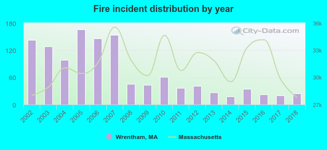 Based on the data from the years 2002 - 2018 the average number of fires per year is 71. The highest number of fires - 166 took place in 2005, and the least - 18 in 2014. The data has a declining trend.
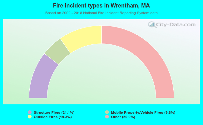 When looking into fire subcategories, the most reports belonged to: Other (50.0%), and Structure Fires (21.1%).
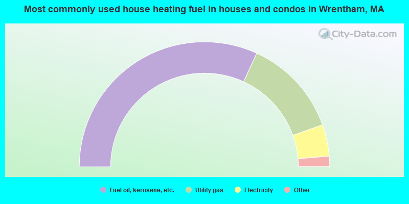
- 63.7%Fuel oil, kerosene, etc.
- 25.4%Utility gas
- 8.2%Electricity
- 1.2%Bottled, tank, or LP gas
- 1.2%Wood
- 0.3%Coal or coke
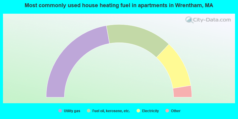
- 44.5%Utility gas
- 29.6%Fuel oil, kerosene, etc.
- 20.8%Electricity
- 3.4%Bottled, tank, or LP gas
- 1.7%Wood
Wrentham compared to Massachusetts state average:
- Median household income above state average.
- Unemployed percentage significantly below state average.
- Black race population percentage significantly below state average.
- Hispanic race population percentage significantly below state average.
- Median age above state average.
- Foreign-born population percentage significantly below state average.
- Renting percentage significantly below state average.
- Length of stay since moving in significantly above state average.
- Number of rooms per house significantly below state average.
- House age significantly below state average.
- Institutionalized population percentage above state average.
Wrentham on our top lists:
- #7 on the list of "Top 101 cities with largest percentage of females in industries: paper and paper products merchant wholesalers (population 5,000+)"
- #13 on the list of "Top 101 cities with largest percentage of males in occupations: special education teachers (population 5,000+)"
- #20 on the list of "Top 101 cities with the largest percentage of people in schools, hospitals, or wards for the mentally retarded (population 1,000+)"
- #21 on the list of "Top 101 cities with largest percentage of males in industries: electrical and electronic goods merchant wholesalers (population 5,000+)"
- #23 on the list of "Top 101 cities with largest percentage of females in occupations: other management occupations except farmers and farm managers (population 5,000+)"
- #23 on the list of "Top 101 cities with largest percentage of females in occupations: religious workers (population 5,000+)"
- #27 on the list of "Top 101 cities with the largest city-data.com crime index decrease from 2011 to 2012 (population 5,000+)"
- #46 on the list of "Top 101 cities with largest percentage of females in occupations: therapists (population 5,000+)"
- #49 on the list of "Top 101 cities with largest percentage of males in industries: computer and electronic products (population 5,000+)"
- #50 on the list of "Top 101 cities with largest percentage of males in industries: metals and minerals, except petroleum, merchant wholesalers (population 5,000+)"
- #53 on the list of "Top 101 cities with largest percentage of males in industries: furniture and home furnishing merchant wholesalers (population 5,000+)"
- #58 on the list of "Top 101 cities with largest percentage of males in occupations: sales representatives, services, wholesale and manufacturing (population 5,000+)"
- #62 on the list of "Top 101 cities with largest percentage of females in industries: machinery, equipment, and supplies merchant wholesalers (population 5,000+)"
- #63 on the list of "Top 101 cities with largest percentage of males in industries: drugs, sundries, and chemical and allied products merchant wholesalers (population 5,000+)"
- #64 on the list of "Top 101 cities with largest percentage of males in industries: apparel, fabrics, and notions merchant wholesalers (population 5,000+)"
- #68 on the list of "Top 101 cities with largest percentage of males in industries: sporting goods, camera, and hobby and toy stores (population 5,000+)"
- #70 on the list of "Top 101 cities with largest percentage of females in industries: repair and maintenance (population 5,000+)"
- #72 on the list of "Top 101 cities with largest percentage of males in industries: broadcasting and telecommunications (population 5,000+)"
- #80 on the list of "Top 101 cities with largest percentage of females in occupations: media and communication equipment workers (population 5,000+)"
- #80 on the list of "Top 101 cities with the lowest number of burglaries per 100,000 residents (population 5,000+)"
- #7 on the list of "Top 101 counties with the highest percentage of residents that visited a dentist within the past year"
- #12 on the list of "Top 101 counties with the lowest percentage of residents that keep firearms around their homes"
- #13 on the list of "Top 101 counties with the best general health status score of residents (1-5), 3 years of data"
- #18 on the list of "Top 101 counties with the lowest Nitrogen Dioxide air pollution readings in 2012 (ppm)"
- #25 on the list of "Top 101 counties with the lowest number of infant deaths per 1000 residents 2007-2013 (pop. 50,000+)"

|
|
Total of 362 patent applications in 2008-2024.