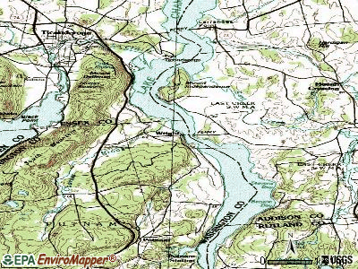
Wright, New York
Submit your own pictures of this town and show them to the world
- OSM Map
- General Map
- Google Map
- MSN Map

Population change since 2000: -0.5%
 |
| Males: 790 | |
| Females: 749 |
| Median resident age: | 44.3 years |
| New York median age: | 40.7 years |
Zip codes: 12157.
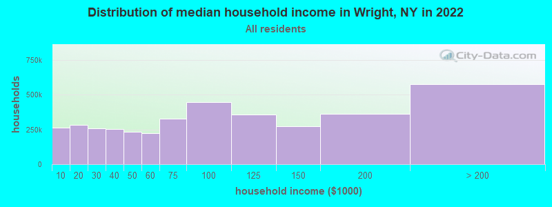
| Wright: | $81,930 |
| NY: | $79,557 |
Estimated per capita income in 2022: $41,551 (it was $19,711 in 2000)
Wright town income, earnings, and wages data
Estimated median house or condo value in 2022: $201,755 (it was $94,600 in 2000)
| Wright: | $201,755 |
| NY: | $400,400 |
Mean prices in 2022: all housing units: $252,981; detached houses: $251,743; townhouses or other attached units: $651,465; in 2-unit structures: $331,466; in 3-to-4-unit structures: $345,769; in 5-or-more-unit structures: $539,440; mobile homes: $176,556
Detailed information about poverty and poor residents in Wright, NY
Compare current foreclosures near Wright, NY:
| Photo | Address | Area | Beds / Baths | Price | Details |
|---|---|---|---|---|---|

|
#1
New Scotland Rd
Voorheesville, NY 12186
|
2,319 sq. feet
|
2 baths 4 beds |
$149,900
|
show details |

|
#2
Floral Ave
Schenectady, NY 12306
|
1,446 sq. feet
|
1 baths 3 beds |
show details | |

|
#3
Scribner Ave
Middleburgh, NY 12122
|
1,533 sq. feet
|
2 baths 2 beds |
show details | |

|
#4
Canady Hill Rd
Middleburgh, NY 12122
|
168 sq. feet
|
2 baths 3 beds |
show details | |

|
#5
Hendricks St
Schenectady, NY 12306
|
1,632 sq. feet
|
1 baths 3 beds |
show details | |

|
#6
Willett St
Schenectady, NY 12303
|
1,944 sq. feet
|
2 baths 4 beds |
show details | |

|
#7
State Route 30
Middleburgh, NY 12122
|
1,112 sq. feet
|
2 baths 4 beds |
show details | |

|
#8
May Ave
Schenectady, NY 12303
|
1,596 sq. feet
|
1 baths 2 beds |
show details | |

|
#9
Broadway
Schenectady, NY 12306
|
1,728 sq. feet
|
1 baths 4 beds |
show details | |

|
#10
Inner Dr
Schenectady, NY 12303
|
1,565 sq. feet
|
1 baths 4 beds |
show details |
| Photo | Address | Area | Beds / Baths | Price | Details |
|---|---|---|---|---|---|

|
#11
Marilyn St
Schenectady, NY 12303
|
1,924 sq. feet
|
1 baths 3 beds |
show details | |

|
#12
Outer Dr
Schenectady, NY 12303
|
1,937 sq. feet
|
1 baths 4 beds |
show details | |

|
#13
Eugene Dr
Schenectady, NY 12303
|
1,960 sq. feet
|
2 baths 3 beds |
show details | |

|
#14
State Highway 161
Amsterdam, NY 12010
|
2,240 sq. feet
|
2 baths 3 beds |
show details | |

|
#15
Chrisler Ave
Schenectady, NY 12303
|
1,790 sq. feet
|
2 baths 5 beds |
show details | |

|
#16
Clement Rd
Schenectady, NY 12303
|
1,170 sq. feet
|
1 baths 3 beds |
show details | |

|
#17
Gladstone St
Schenectady, NY 12303
|
1,296 sq. feet
|
1 baths 3 beds |
show details | |

|
#18
Chrisler Ave
Schenectady, NY 12303
|
2,320 sq. feet
|
2 baths 6 beds |
show details | |

|
#19
Roberta Rd
Schenectady, NY 12303
|
2,120 sq. feet
|
2 baths 3 beds |
show details | |

|
#20
Fifth St, # 2
Schenectady, NY 12306
|
2,320 sq. feet
|
2 baths 6 beds |
show details |
| Photo | Address | Area | Beds / Baths | Price | Details |
|---|---|---|---|---|---|

|
#21
Nott Rd
Guilderland, NY 12084
|
2,058 sq. feet
|
2 baths 4 beds |
show details | |

|
#22
Bernice St
Schenectady, NY 12303
|
1,596 sq. feet
|
1 baths 2 beds |
show details | |

|
#23
Pleasantview Ave
Schenectady, NY 12302
|
1,254 sq. feet
|
1 baths 3 beds |
show details | |

|
#24
S Toll St
Schenectady, NY 12302
|
1,152 sq. feet
|
1 baths 3 beds |
show details | |

|
#25
Carlton St
Schenectady, NY 12306
|
1,252 sq. feet
|
1 baths 3 beds |
show details | |

|
#26
Amsterdam Ave
Schenectady, NY 12303
|
2,000 sq. feet
|
2 baths 4 beds |
show details | |

|
#27
Spawn Rd
Schenectady, NY 12303
|
1,116 sq. feet
|
1 baths 3 beds |
show details | |

|
#28
Evergreen Rd
Cobleskill, NY 12043
|
1,708 sq. feet
|
1 baths 3 beds |
show details | |

|
#29
Gordon Rd
Schenectady, NY 12306
|
1,100 sq. feet
|
1 baths 2 beds |
show details | |

|
#30
Fort Hunter Rd
Schenectady, NY 12303
|
1,317 sq. feet
|
1 baths 2 beds |
show details |
| Photo | Address | Area | Beds / Baths | Price | Details |
|---|---|---|---|---|---|

|
#31
Deerfield Ct
Voorheesville, NY 12186
|
1,672 sq. feet
|
1 baths 3 beds |
show details | |

|
#32
Morning Glory Way
Schenectady, NY 12306
|
1,265 sq. feet
|
2 baths 2 beds |
show details | |

|
#33
Hollywood Ave
Schenectady, NY 12306
|
1,062 sq. feet
|
1 baths 2 beds |
show details | |

|
#34
Thirteenth St
Schenectady, NY 12306
|
1,232 sq. feet
|
1 baths 3 beds |
show details | |

|
#35
Manas Dr
Schenectady, NY 12303
|
1,344 sq. feet
|
1 baths 3 beds |
show details | |

|
#36
Bulls Head Rd
Amsterdam, NY 12010
|
1,300 sq. feet
|
1 baths 2 beds |
show details | |

|
#37
Ridgefield Dr
Voorheesville, NY 12186
|
1,745 sq. feet
|
2 baths 3 beds |
show details | |

|
#38
Helderberg Trl
Berne, NY 12023
|
2,198 sq. feet
|
2 baths 3 beds |
show details | |

|
#39
Elizabeth St
Schenectady, NY 12303
|
1,729 sq. feet
|
2 baths 4 beds |
show details | |

|
#40
Appleblossom Ln
Voorheesville, NY 12186
|
1,092 sq. feet
|
1 baths 3 beds |
show details |
| Photo | Address | Area | Beds / Baths | Price | Details |
|---|---|---|---|---|---|

|
#41
Elizabeth St
Schenectady, NY 12303
|
1,764 sq. feet
|
1 baths 4 beds |
show details | |

|
#42
Helderberg Ave
Schenectady, NY 12306
|
1,272 sq. feet
|
1 baths 3 beds |
show details | |

|
#43
Arthur St
Schenectady, NY 12306
|
891 sq. feet
|
1 baths 2 beds |
show details | |

|
#44
Christopher Ln
Schenectady, NY 12303
|
1,075 sq. feet
|
2 baths 3 beds |
show details | |

|
#45
Chrisler Ave
Schenectady, NY 12303
|
2,046 sq. feet
|
2 baths 6 beds |
show details | |

|
#46
Helderberg Trl
Berne, NY 12023
|
1,998 sq. feet
|
1 baths 3 beds |
show details | |

|
#47
Willett St
Schenectady, NY 12303
|
1,390 sq. feet
|
1 baths 4 beds |
show details | |

|
#48
New Scotland Rd
Slingerlands, NY 12159
|
2,343 sq. feet
|
2 baths 4 beds |
show details | |

|
#49
Elbert St
Schenectady, NY 12304
|
2,526 sq. feet
|
2 baths 6 beds |
show details | |

|
Check over 1 million property listings on Foreclosure.com!
|
browse all offers | |||

- 1,49697.2%White alone
- 201.3%Hispanic
- 90.6%Two or more races
- 80.5%Black alone
- 60.4%Asian alone
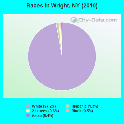
Races in Wright detailed stats: ancestries, foreign born residents, place of birth
 Recent articles from our blog. Our writers, many of them Ph.D. graduates or candidates, create easy-to-read articles on a wide variety of topics.


 | Buffalo-Boom/Bust II (584 replies) |
| smaller Upstate NY cities and towns/African American communities (5948 replies) |
| Remember when...Oceanside (175 replies) |
| Why don't we have a Hudson Valley forum? (61 replies) |
| Inno has arrived in Albany. Here's what to expect... (104 replies) |
| Buffalo Trip Ideas (12 replies) |
Latest news from Wright, NY collected exclusively by city-data.com from local newspapers, TV, and radio stations
Ancestries: German (21.7%), Irish (15.4%), English (13.0%), United States (11.0%), Italian (9.4%), Dutch (6.8%).
Current Local Time: EST time zone
Elevation: 158 feet
Land area: 28.6 square miles.
Population density: 54 people per square mile (very low).
21 residents are foreign born
| This town: | 1.4% |
| New York: | 20.4% |
| Wright town: | 1.7% ($1,634) |
| New York: | 1.9% ($2,847) |
Nearest city with pop. 50,000+: Schenectady, NY  (16.7 miles , pop. 61,821).
Nearest city with pop. 200,000+: Bronx, NY (127.5 miles , pop. 1,332,650).
Nearest cities:
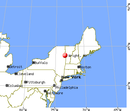
), ), ), ), ), ), ), )Latitude: 42.67 N, Longitude: 74.21 W
Area code commonly used in this area: 518

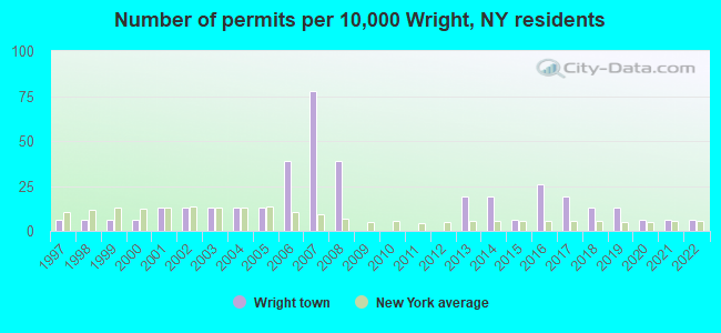
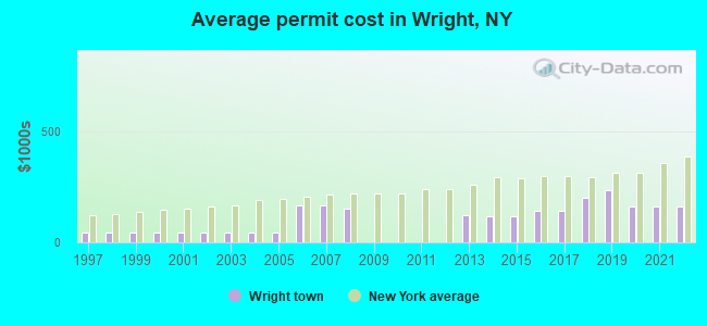
Single-family new house construction building permits:
- 2022: 1 building, cost: $160,000
- 2021: 1 building, cost: $160,000
- 2020: 1 building, cost: $160,000
- 2019: 2 buildings, average cost: $235,000
- 2018: 2 buildings, average cost: $200,000
- 2017: 3 buildings, average cost: $140,000
- 2016: 4 buildings, average cost: $140,000
- 2015: 1 building, cost: $116,700
- 2014: 3 buildings, average cost: $116,700
- 2013: 3 buildings, average cost: $123,300
- 2008: 6 buildings, average cost: $150,000
- 2007: 12 buildings, average cost: $166,700
- 2006: 6 buildings, average cost: $166,700
- 2005: 2 buildings, average cost: $45,000
- 2004: 2 buildings, average cost: $45,000
- 2003: 2 buildings, average cost: $45,000
- 2002: 2 buildings, average cost: $45,000
- 2001: 2 buildings, average cost: $45,000
- 2000: 1 building, cost: $45,000
- 1999: 1 building, cost: $45,000
- 1998: 1 building, cost: $45,000
- 1997: 1 building, cost: $45,000
| Here: | 4.5% |
| New York: | 4.4% |
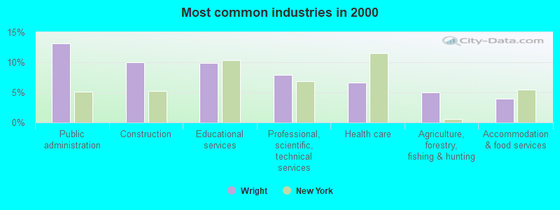
- Public administration (13.1%)
- Construction (10.0%)
- Educational services (9.9%)
- Professional, scientific, technical services (7.9%)
- Health care (6.6%)
- Agriculture, forestry, fishing & hunting (5.0%)
- Accommodation & food services (3.9%)
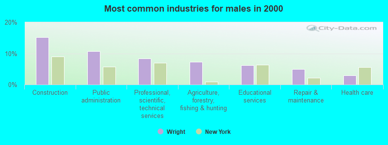
- Construction (15.3%)
- Public administration (10.7%)
- Professional, scientific, technical services (8.4%)
- Agriculture, forestry, fishing & hunting (7.3%)
- Educational services (6.2%)
- Repair & maintenance (5.0%)
- Health care (3.0%)
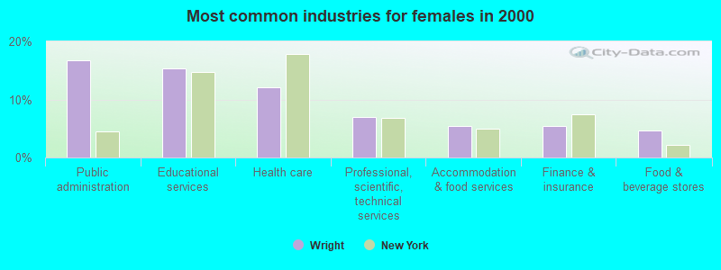
- Public administration (16.7%)
- Educational services (15.4%)
- Health care (12.0%)
- Professional, scientific, technical services (7.0%)
- Accommodation & food services (5.4%)
- Finance & insurance (5.4%)
- Food & beverage stores (4.7%)
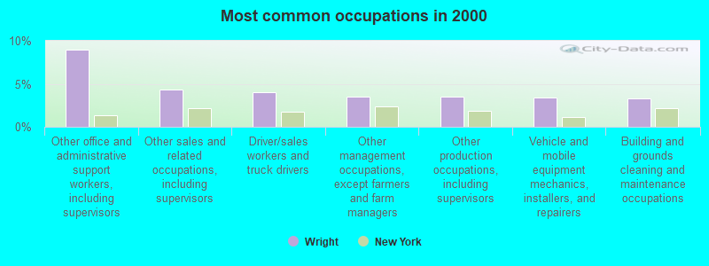
- Other office and administrative support workers, including supervisors (8.9%)
- Other sales and related occupations, including supervisors (4.3%)
- Driver/sales workers and truck drivers (4.1%)
- Other management occupations, except farmers and farm managers (3.5%)
- Other production occupations, including supervisors (3.5%)
- Vehicle and mobile equipment mechanics, installers, and repairers (3.4%)
- Building and grounds cleaning and maintenance occupations (3.3%)
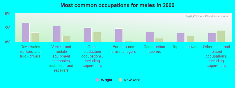
- Driver/sales workers and truck drivers (6.8%)
- Vehicle and mobile equipment mechanics, installers, and repairers (5.7%)
- Other production occupations, including supervisors (5.0%)
- Farmers and farm managers (4.8%)
- Construction laborers (3.6%)
- Top executives (3.2%)
- Other sales and related occupations, including supervisors (3.2%)
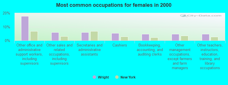
- Other office and administrative support workers, including supervisors (17.7%)
- Other sales and related occupations, including supervisors (6.0%)
- Secretaries and administrative assistants (6.0%)
- Cashiers (5.4%)
- Bookkeeping, accounting, and auditing clerks (4.7%)
- Other management occupations, except farmers and farm managers (4.7%)
- Other teachers, instructors, education, training, and library occupations (4.7%)
Average climate in Wright, New York
Based on data reported by over 4,000 weather stations


(lower is better)
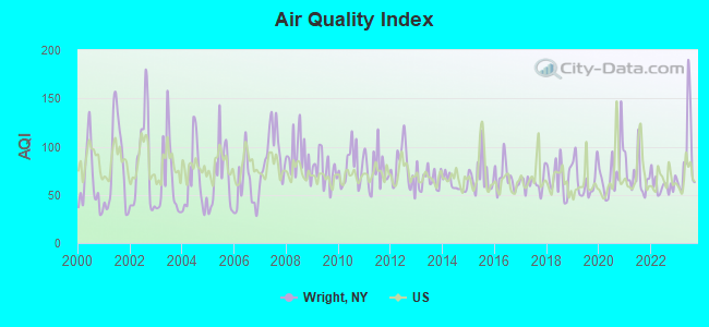
Air Quality Index (AQI) level in 2023 was 89.2. This is worse than average.
| City: | 89.2 |
| U.S.: | 72.6 |
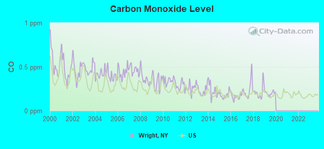
Carbon Monoxide (CO) [ppm] level in 2019 was 0.199. This is better than average. Closest monitor was 16.1 miles away from the city center.
| City: | 0.199 |
| U.S.: | 0.251 |
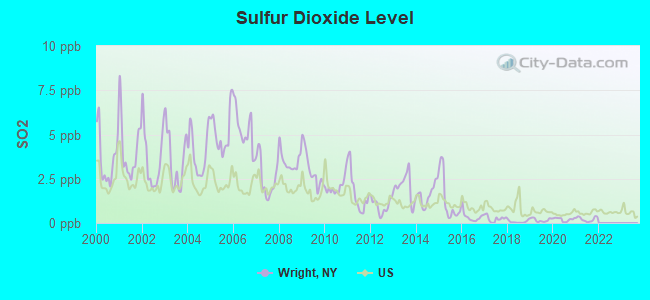
Sulfur Dioxide (SO2) [ppb] level in 2021 was 0.213. This is significantly better than average. Closest monitor was 16.1 miles away from the city center.
| City: | 0.213 |
| U.S.: | 1.515 |
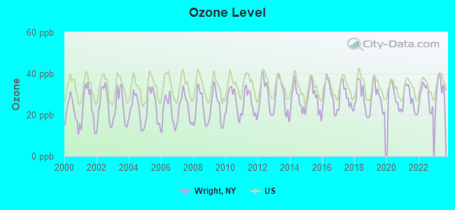
Ozone [ppb] level in 2023 was 32.1. This is about average. Closest monitor was 16.1 miles away from the city center.
| City: | 32.1 |
| U.S.: | 33.3 |
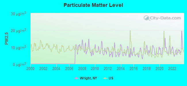
Particulate Matter (PM2.5) [µg/m3] level in 2023 was 9.66. This is about average. Closest monitor was 16.1 miles away from the city center.
| City: | 9.66 |
| U.S.: | 8.11 |
Tornado activity:
Wright-area historical tornado activity is slightly above New York state average. It is 55% smaller than the overall U.S. average.
On 7/10/1989, a category F4 (max. wind speeds 207-260 mph) tornado 19.7 miles away from the Wright town center injured 20 people and caused between $5,000,000 and $50,000,000 in damages.
On 6/24/1960, a category F3 (max. wind speeds 158-206 mph) tornado 18.7 miles away from the town center injured 9 people and caused between $5,000,000 and $50,000,000 in damages.
Earthquake activity:
Wright-area historical earthquake activity is significantly above New York state average. It is 67% smaller than the overall U.S. average.On 10/7/1983 at 10:18:46, a magnitude 5.3 (5.1 MB, 5.3 LG, 5.1 ML, Class: Moderate, Intensity: VI - VII) earthquake occurred 88.8 miles away from the city center
On 4/20/2002 at 10:50:47, a magnitude 5.3 (5.3 ML, Depth: 3.0 mi) earthquake occurred 129.7 miles away from Wright center
On 4/20/2002 at 10:50:47, a magnitude 5.2 (5.2 MB, 4.2 MS, 5.2 MW, 5.0 MW) earthquake occurred 127.8 miles away from Wright center
On 1/19/1982 at 00:14:42, a magnitude 4.7 (4.5 MB, 4.7 MD, 4.5 LG, Class: Light, Intensity: IV - V) earthquake occurred 143.5 miles away from the city center
On 6/17/1991 at 08:53:16, a magnitude 4.1 (4.0 MB, 4.0 LG, Depth: 3.1 mi) earthquake occurred 24.2 miles away from the city center
On 8/23/2011 at 17:51:04, a magnitude 5.8 (5.8 MW, Depth: 3.7 mi) earthquake occurred 383.7 miles away from Wright center
Magnitude types: regional Lg-wave magnitude (LG), body-wave magnitude (MB), duration magnitude (MD), local magnitude (ML), surface-wave magnitude (MS), moment magnitude (MW)
Natural disasters:
The number of natural disasters in Schoharie County (26) is a lot greater than the US average (15).Major Disasters (Presidential) Declared: 15
Emergencies Declared: 10
Causes of natural disasters: Floods: 8, Storms: 8, Hurricanes: 5, Snowstorms: 3, Winter Storms: 3, Tropical Storms: 2, Blizzard: 1, Power Outage: 1, Tropical Depression: 1, Other: 2 (Note: some incidents may be assigned to more than one category).
Amtrak stations near Wright:
- 17 miles: SCHENECTADY (332 ERIE BLVD.) . Services: ticket office, fully wheelchair accessible, enclosed waiting area, public restrooms, public payphones, vending machines, ATM, free short-term parking, free long-term parking, call for car rental service, taxi stand, public transit connection.
- 19 miles: AMSTERDAM (RAILROAD & W. MAIN STS.) . Services: enclosed waiting area, public restrooms, public payphones, free short-term parking, free long-term parking, call for car rental service, call for taxi service, public transit connection.
Colleges/universities with over 2000 students nearest to Wright:
- SUNY College of Agriculture and Technology at Cobleskill (about 16 miles; Cobleskill, NY; Full-time enrollment: 2,455)
- Schenectady County Community College (about 17 miles; Schenectady, NY; FT enrollment: 3,676)
- Union College (about 18 miles; Schenectady, NY; FT enrollment: 2,075)
- Excelsior College (about 18 miles; Albany, NY; FT enrollment: 4,723)
- SUNY at Albany (about 20 miles; Albany, NY; FT enrollment: 15,490)
- The College of Saint Rose (about 22 miles; Albany, NY; FT enrollment: 4,085)
- Fulton-Montgomery Community College (about 22 miles; Johnstown, NY; FT enrollment: 2,043)
Points of interest:
Cemeteries: Barton Hill Cemetery (1), Gallupville Rural Cemetery (2), Zimmer Cemetery (3). Display/hide their locations on the map
Reservoir: Echo Pond (A). Display/hide its location on the map
Streams, rivers, and creeks: Ox Kill (A), Louse Kill (B), King Creek (C). Display/hide their locations on the map
| This town: | 2.5 people |
| New York: | 2.6 people |
| This town: | 72.0% |
| Whole state: | 63.5% |
| This town: | 7.0% |
| Whole state: | 6.8% |
Likely homosexual households (counted as self-reported same-sex unmarried-partner households)
- Lesbian couples: 0.2% of all households
- Gay men: 0.3% of all households
| This town: | 8.9% |
| Whole state: | 14.6% |
| This town: | 5.0% |
| Whole state: | 7.4% |
For population 15 years and over in Wright:
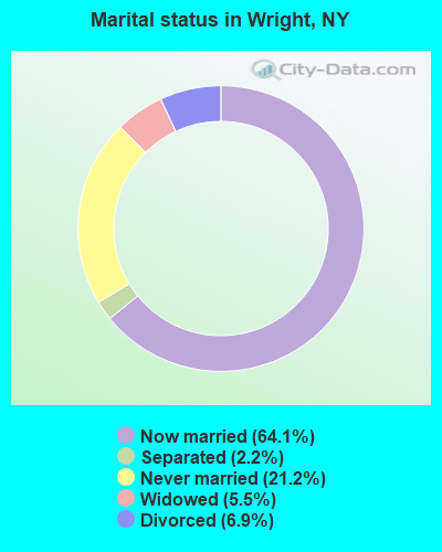
- Never married: 21.2%
- Now married: 64.1%
- Separated: 2.2%
- Widowed: 5.5%
- Divorced: 6.9%
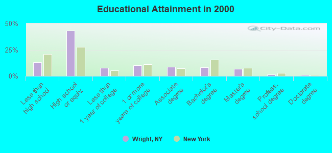
For population 25 years and over in Wright:
- High school or higher: 87.1%
- Bachelor's degree or higher: 17.7%
- Graduate or professional degree: 9.2%
- Unemployed: 3.9%
- Mean travel time to work (commute): 34.5 minutes
| Here: | 9.9 |
| New York average: | 14.2 |
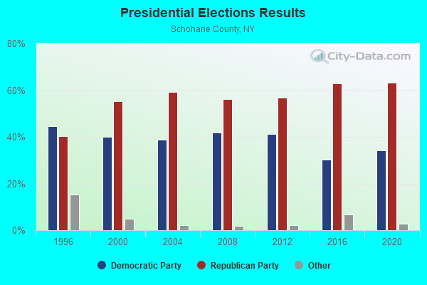
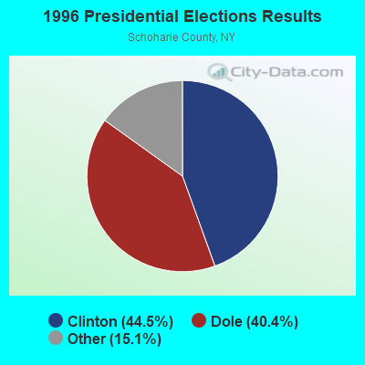
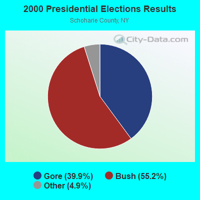
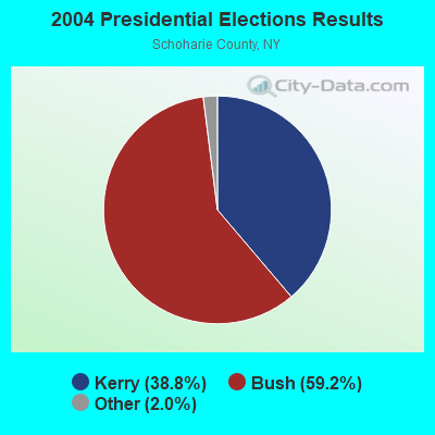
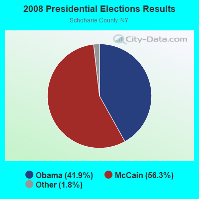
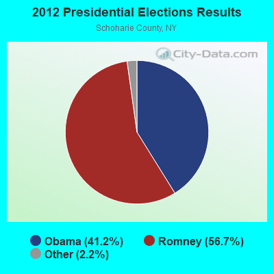
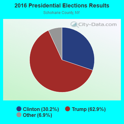
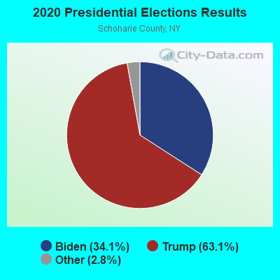
Graphs represent county-level data. Detailed 2008 Election Results
Religion statistics for Wright, NY (based on Schoharie County data)
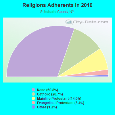
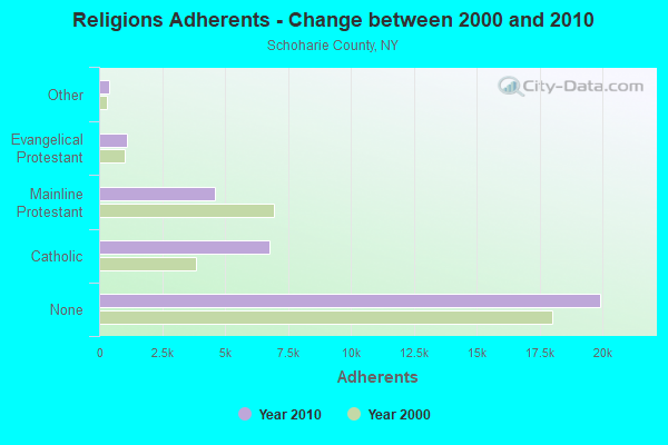
| Religion | Adherents | Congregations |
|---|---|---|
| Catholic | 6,768 | 3 |
| Mainline Protestant | 4,578 | 36 |
| Evangelical Protestant | 1,099 | 19 |
| Other | 391 | 2 |
| Orthodox | - | - |
| None | 19,913 | - |
Food Environment Statistics:
| Here: | 0.63 / 10,000 pop. |
| State: | 4.13 / 10,000 pop. |
| Schoharie County: | 0.31 / 10,000 pop. |
| New York: | 0.06 / 10,000 pop. |
| This county: | 0.31 / 10,000 pop. |
| New York: | 0.92 / 10,000 pop. |
| This county: | 5.95 / 10,000 pop. |
| State: | 1.68 / 10,000 pop. |
| Schoharie County: | 7.83 / 10,000 pop. |
| New York: | 8.82 / 10,000 pop. |
| Schoharie County: | 8.9% |
| State: | 8.2% |
| This county: | 24.3% |
| State: | 23.8% |
| Schoharie County: | 13.2% |
| New York: | 15.6% |
Strongest AM radio stations in Wright:
- WGY (810 AM; 50 kW; SCHENECTADY, NY; Owner: CLEAR CHANNEL BROADCASTING LICENSES, INC.)
- WPTR (1540 AM; 50 kW; ALBANY, NY; Owner: KIMTRON, INC.)
- WROW (590 AM; 5 kW; ALBANY, NY; Owner: 6 JOHNSON ROAD LICENSES, INC.)
- WOFX (980 AM; 5 kW; TROY, NY)
- WNNZ (640 AM; 50 kW; WESTFIELD, MA; Owner: CLEAR CHANNEL BROADCASTING LICENSES, INC.)
- WDDY (1460 AM; 5 kW; ALBANY, NY)
- WTMM (1300 AM; 5 kW; RENSSELAER, NY; Owner: REGENT LICENSEE OF MANSFIELD, INC.)
- WXBH (1190 AM; 1 kW; COBLESKILL, NY; Owner: NY COMMUNICATIONS, LLC)
- WTIC (1080 AM; 50 kW; HARTFORD, CT; Owner: INFINITY RADIO OPERATIONS INC.)
- WMCA (570 AM; 50 kW; NEW YORK, NY; Owner: SALEM MEDIA OF NEW YORK, LLC)
- WABY (1160 AM; 5 kW; MECHANICVILLE, NY; Owner: ANASTOS MEDIA GROUP, INC.)
- WFAN (660 AM; 50 kW; NEW YORK, NY; Owner: INFINITY BROADCASTING OPERATIONS, INC.)
- WCRN (830 AM; 50 kW; WORCESTER, MA; Owner: CARTER BROADCASTING CORPORATION)
Strongest FM radio stations in Wright:
- WMYY (97.3 FM; SCHOHARIE, NY; Owner: CAPITAL MEDIA CORPORATION)
- WAJZ (96.3 FM; VOORHEESVILLE, NY; Owner: 6 JOHNSON ROAD LICENSES, INC.)
- WZMR (104.9 FM; ALTAMONT, NY; Owner: 6 JOHNSON ROAD LICENSES, INC.)
- WYJB (95.5 FM; ALBANY, NY; Owner: 6 JOHNSON ROAD LICENSES, INC.)
- WGNA-FM (107.7 FM; ALBANY, NY; Owner: REGENT LICENSEE OF MANSFIELD, INC.)
- WMHT-FM (89.1 FM; SCHENECTADY, NY; Owner: WMHT EDUCATIONAL TELECOMMUNICATIONS)
- WPYX (106.5 FM; ALBANY, NY; Owner: CAPSTAR TX LIMITED PARTNERSHIP)
- WRVE (99.5 FM; SCHENECTADY, NY; Owner: CLEAR CHANNEL BROADCASTING LICENSES, INC.)
- WVCR-FM (88.3 FM; LOUDONVILLE, NY; Owner: SIENA COLLEGE)
- WFLY (92.3 FM; TROY, NY; Owner: 6 JOHNSON ROAD LICENSES, INC.)
- WPGL (90.7 FM; PATTERSONVILLE, NY; Owner: SOUND OF LIFE, INC.)
- WTRY-FM (98.3 FM; ROTTERDAM, NY; Owner: CAPSTAR TX LIMITED PARTNERSHIP)
- WGKR (105.3 FM; GRAND GORGE, NY; Owner: SOUND OF LIFE, INC.)
- WJIV (101.9 FM; CHERRY VALLEY, NY; Owner: CHRISTIAN BROADCASTING SYSTEM, LTD.)
- WRIP (97.9 FM; WINDHAM, NY; Owner: RIP RADIO, LLC)
- WAMK (90.9 FM; KINGSTON, NY; Owner: W A M C)
- WBKK (97.7 FM; AMSTERDAM, NY; Owner: GEM ASSOCIATES, L. P.)
- WFGB (89.7 FM; KINGSTON, NY; Owner: SOUND OF LIFE, INC.)
- WAMC-FM (90.3 FM; ALBANY, NY; Owner: WAMC)
- WEQX (102.7 FM; MANCHESTER, VT; Owner: NORTHSHIRE COMMUNICATIONS, INC.)
TV broadcast stations around Wright:
- WNYT (Channel 13; ALBANY, NY; Owner: WNYT-TV, LLC)
- WEWB-TV (Channel 45; SCHENECTADY, NY; Owner: WEWB, L.L.C.)
- WMHT (Channel 17; SCHENECTADY, NY; Owner: WMHT EDUCATIONAL TELECOMMUNICATIONS)
- WRGB (Channel 6; SCHENECTADY, NY; Owner: FREEDOM BROADCASTING OF NEW YORK, INC)
- WTEN (Channel 10; ALBANY, NY; Owner: YOUNG BROADCASTING OF ALBANY, INC.)
- WXXA-TV (Channel 23; ALBANY, NY; Owner: CLEAR CHANNEL BROADCASTING LICENSES, INC.)
- WYPX (Channel 55; AMSTERDAM, NY; Owner: PAXSON ALBANY LICENSE, INC.)
- W52DF (Channel 52; ALBANY, NY; Owner: TRINITY BROADCASTING NETWORK)
- WVBG-LP (Channel 25; GREENWICH, NY; Owner: WIRELESS ACCESS, LLC)
- W58CX (Channel 58; SARATOGA SPRINGS, NY; Owner: THREE ANGELS BROADCASTING NETWORK)
- W07AN (Channel 7; SCHOHARIE, ETC., NY; Owner: YOUNG BROADCASTING OF ALBANY, INC.)
- W04AJ (Channel 4; SCHOHARIE, ETC., NY; Owner: WMHT EDUCATIONAL TELECOMMUNICATIONS)
- National Bridge Inventory (NBI) Statistics
- 10Number of bridges
- 85ft / 26.2mTotal length
- $13,347,000Total costs
- 2,878Total average daily traffic
- 255Total average daily truck traffic
- 3,461Total future (year 2031) average daily traffic
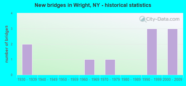
- New bridges - historical statistics
- 21930-1939
- 11960-1969
- 11970-1979
- 31990-1999
- 32000-2009
FCC Registered Antenna Towers:
4- Kory Fretto, 247 Zimmer Road (Lat: 42.652861 Lon: -74.195528), Type: 47.2, Overall height: 45.7 m, Registrant: Independent Towers, LLC, Kfretto@independenttowers.Com, , Latha-m, Phone: (518) 690-0790
- Todd J Bowman, 247 Zimmer Road (Lat: 42.652861 Lon: -74.195528), Type: 47.2, Overall height: 45.7 m, Registrant: Florida Tower Partners, LLC D/B/A North Atlantic Towers, Tbowman@tarpontowers.Com, , Brade-nton, Phone: (941) 757-5010
- Todd J Bowman, 247 Zimmer Road (Lat: 42.652861 Lon: -74.195528), Type: 47.2, Overall height: 45.7 m, Registrant: Florida Tower Partners, LLC D/B/A North Atlantic Towers, Tbowman@tarpontowers.Com, , Brade-nton, Phone: (941) 757-5010
- Bridget Carter, 247 Zimmer Road (Lat: 42.652861 Lon: -74.195528), Type: 47.2, Structure height: 36095 m, Overall height: 45.7 m, Registrant: Florida Tower Partners, LLC D/B/A North Atlantic Towers, Tbowman@tarpontowers.Com, , Brade-nton, Phone: (941) 757-5010
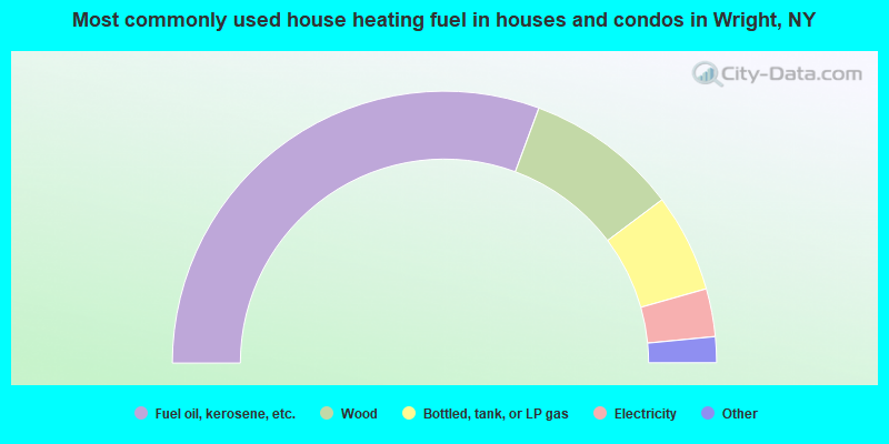
- 61.3%Fuel oil, kerosene, etc.
- 18.2%Wood
- 11.7%Bottled, tank, or LP gas
- 5.7%Electricity
- 1.2%Coal or coke
- 1.0%Utility gas
- 0.8%Solar energy
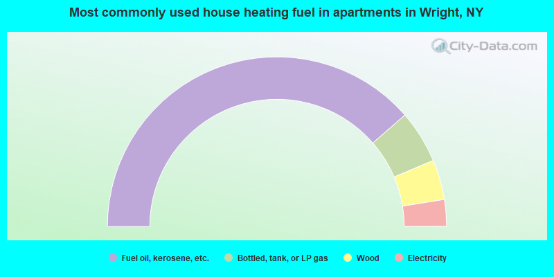
- 77.2%Fuel oil, kerosene, etc.
- 10.1%Bottled, tank, or LP gas
- 7.6%Wood
- 5.1%Electricity
Wright compared to New York state average:
- Median house value below state average.
- Unemployed percentage significantly below state average.
- Black race population percentage significantly below state average.
- Hispanic race population percentage significantly below state average.
- Foreign-born population percentage significantly below state average.
- Renting percentage significantly below state average.
- Length of stay since moving in significantly above state average.
- Number of rooms per house significantly below state average.
- House age significantly below state average.
- Number of college students below state average.
- Percentage of population with a bachelor's degree or higher below state average.

|
Total of 1 patent application in 2008-2024.