Cedar Rapids, Iowa

Cedar Rapids: Sunset on the Cedar River - at a park downstream of downtown
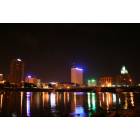
Cedar Rapids: Cedar Rapids Skyline
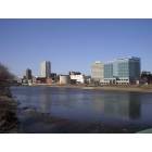
Cedar Rapids: Skyline in Early Spring
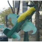
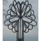
Cedar Rapids: Fly Away!
Cedar Rapids

Cedar Rapids: Winter Crabapple Tree - Jones Park area - Cedar Rapids
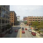
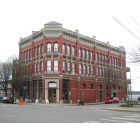
Cedar Rapids: another that i took from the skywalk

Cedar Rapids: Brucemore garden October 2012

Cedar Rapids: Cedar Rapids skyline from the west side of the Cedar River. April 2009
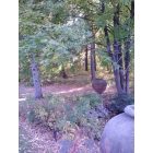
Cedar Rapids: Brucemore garden October 2012
Cedar Rapids: City of Five Seasons
- see
17
more - add
your


Submit your own pictures of this city and show them to the world
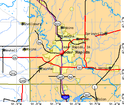
- OSM Map
- General Map
- Google Map
- MSN Map
Population change since 2000: +13.0%
 |
| Males: 66,653 | |
| Females: 69,776 |
| Median resident age: | 39.1 years |
| Iowa median age: | 38.9 years |
Zip codes: 52227, 52228, 52233, 52302, 52324, 52328, 52338, 52401, 52402, 52404, 52405, 52411.
Cedar Rapids Zip Code Map| Cedar Rapids: | $64,435 |
| IA: | $69,588 |
Estimated per capita income in 2022: $38,066 (it was $22,589 in 2000)
Cedar Rapids city income, earnings, and wages data
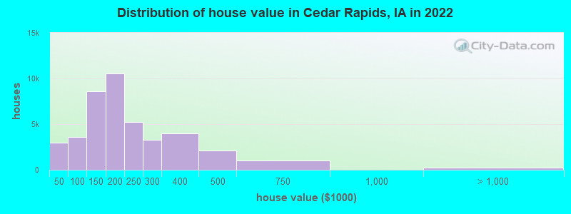
Estimated median house or condo value in 2022: $173,200 (it was $92,900 in 2000)
| Cedar Rapids: | $173,200 |
| IA: | $194,600 |
Mean prices in 2022: all housing units: $201,584; detached houses: $213,344; townhouses or other attached units: $208,186; in 2-unit structures: $181,669; in 3-to-4-unit structures: $123,362; in 5-or-more-unit structures: $180,307; mobile homes: $33,824
Median gross rent in 2022: $835.
(10.1% for White Non-Hispanic residents, 26.6% for Black residents, 17.4% for Hispanic or Latino residents, 11.0% for American Indian residents, 72.3% for Native Hawaiian and other Pacific Islander residents, 28.3% for other race residents, 24.3% for two or more races residents)
Detailed information about poverty and poor residents in Cedar Rapids, IA


- 106,40377.8%White alone
- 11,8848.7%Black alone
- 7,9415.8%Two or more races
- 6,2394.6%Hispanic
- 3,8852.8%Asian alone
- 1,3811.0%Other race alone
- 3830.3%Native Hawaiian and Other
Pacific Islander alone - 2720.2%American Indian alone
Races in Cedar Rapids detailed stats: ancestries, foreign born residents, place of birth
According to our research of Iowa and other state lists, there were 306 registered sex offenders living in Cedar Rapids, Iowa as of April 19, 2024.
The ratio of all residents to sex offenders in Cedar Rapids is 427 to 1.
The ratio of registered sex offenders to all residents in this city is near the state average.
The City-Data.com crime index weighs serious crimes and violent crimes more heavily. Higher means more crime, U.S. average is 246.1. It adjusts for the number of visitors and daily workers commuting into cities.
- means the value is smaller than the state average.- means the value is about the same as the state average.
- means the value is bigger than the state average.
- means the value is much bigger than the state average.
Crime rate in Cedar Rapids detailed stats: murders, rapes, robberies, assaults, burglaries, thefts, arson
Full-time law enforcement employees in 2021, including police officers: 280 (223 officers - 187 male; 36 female).
| Officers per 1,000 residents here: | 1.65 |
| Iowa average: | 1.76 |
 Recent articles from our blog. Our writers, many of them Ph.D. graduates or candidates, create easy-to-read articles on a wide variety of topics.


 | Cedar Rapids shooting 2 dead 10 injured (35 replies) |
| Possible move to Cedar Rapids area for retired couple (20 replies) |
| Cedar Rapids casino dream (4 replies) |
| Boating near Iowa City / Cedar Rapids? (2 replies) |
| Relocating to Cedar Rapids from Greensboro NC (19 replies) |
| School shooting, 1 dead, 2 critical, 6 teenagers charged (11 replies) |
Latest news from Cedar Rapids, IA collected exclusively by city-data.com from local newspapers, TV, and radio stations
Ancestries: German (23.8%), Irish (7.3%), English (6.6%), American (6.5%), European (3.6%), Norwegian (2.9%).
Current Local Time: CST time zone
Incorporated on 01/15/1849
Elevation: 727 feet
Land area: 63.1 square miles.
Population density: 2,161 people per square mile (low).
9,451 residents are foreign born (2.6% Asia, 2.3% Africa, 1.0% Latin America).
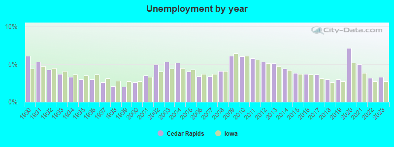
| This city: | 6.9% |
| Iowa: | 5.6% |
Median real estate property taxes paid for housing units with mortgages in 2022: $2,953 (1.7%)
Median real estate property taxes paid for housing units with no mortgage in 2022: $3,128 (1.8%)
Nearest city with pop. 200,000+: Madison, WI  (138.3 miles , pop. 208,054).
Nearest city with pop. 1,000,000+: Chicago, IL (205.5 miles , pop. 2,896,016).
Nearest cities:
), ), Latitude: 41.98 N, Longitude: 91.67 W
Daytime population change due to commuting: +24,276 (+17.8%)
Workers who live and work in this city: 56,759 (77.4%)
Area code: 319
Detailed articles:
- Cedar Rapids: Introduction
- Cedar Rapids Basic Facts
- Cedar Rapids: Communications
- Cedar Rapids: Convention Facilities
- Cedar Rapids: Economy
- Cedar Rapids: Education and Research
- Cedar Rapids: Geography and Climate
- Cedar Rapids: Health Care
- Cedar Rapids: History
- Cedar Rapids: Municipal Government
- Cedar Rapids: Population Profile
- Cedar Rapids: Recreation
- Cedar Rapids: Transportation
Cedar Rapids tourist attractions:
Cedar Rapids, Iowa accommodation & food services, waste management - Economy and Business Data
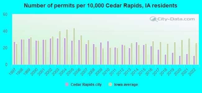
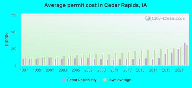
Single-family new house construction building permits:
- 2022: 129 buildings, average cost: $345,300
- 2021: 158 buildings, average cost: $253,500
- 2020: 130 buildings, average cost: $196,700
- 2019: 173 buildings, average cost: $170,800
- 2018: 147 buildings, average cost: $112,800
- 2017: 219 buildings, average cost: $106,200
- 2016: 268 buildings, average cost: $109,100
- 2015: 285 buildings, average cost: $98,600
- 2014: 325 buildings, average cost: $106,500
- 2013: 242 buildings, average cost: $101,400
- 2012: 289 buildings, average cost: $97,000
- 2011: 249 buildings, average cost: $94,000
- 2010: 342 buildings, average cost: $87,500
- 2009: 323 buildings, average cost: $94,700
- 2008: 299 buildings, average cost: $103,900
- 2007: 298 buildings, average cost: $113,500
- 2006: 356 buildings, average cost: $108,800
- 2005: 351 buildings, average cost: $108,500
- 2004: 383 buildings, average cost: $100,700
- 2003: 379 buildings, average cost: $102,200
- 2002: 380 buildings, average cost: $102,000
- 2001: 363 buildings, average cost: $121,900
- 2000: 349 buildings, average cost: $121,500
- 1999: 375 buildings, average cost: $97,400
- 1998: 367 buildings, average cost: $96,200
- 1997: 332 buildings, average cost: $99,200
| Here: | 3.3% |
| Iowa: | 2.7% |
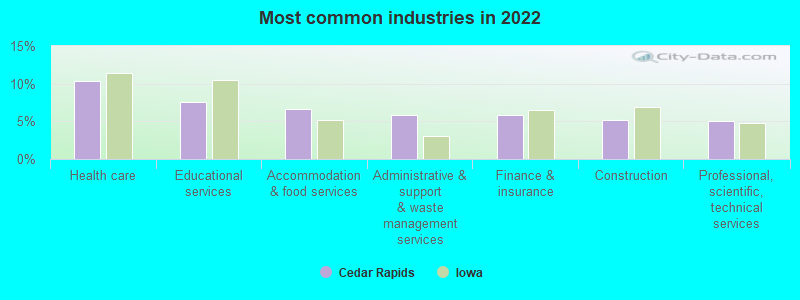
- Health care (10.4%)
- Educational services (7.6%)
- Accommodation & food services (6.6%)
- Administrative & support & waste management services (5.9%)
- Finance & insurance (5.8%)
- Construction (5.2%)
- Professional, scientific, technical services (5.0%)
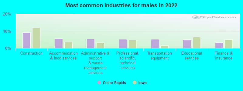
- Construction (9.2%)
- Accommodation & food services (5.6%)
- Administrative & support & waste management services (5.4%)
- Professional, scientific, technical services (5.3%)
- Transportation equipment (5.3%)
- Educational services (5.1%)
- Finance & insurance (3.4%)
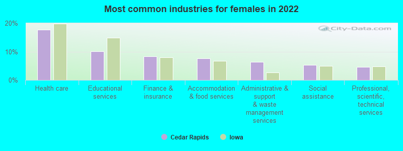
- Health care (17.6%)
- Educational services (10.1%)
- Finance & insurance (8.3%)
- Accommodation & food services (7.6%)
- Administrative & support & waste management services (6.3%)
- Social assistance (5.2%)
- Professional, scientific, technical services (4.7%)
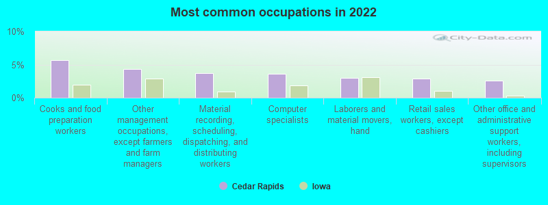
- Cooks and food preparation workers (5.7%)
- Other management occupations, except farmers and farm managers (4.4%)
- Material recording, scheduling, dispatching, and distributing workers (3.7%)
- Computer specialists (3.6%)
- Laborers and material movers, hand (3.0%)
- Retail sales workers, except cashiers (2.9%)
- Other office and administrative support workers, including supervisors (2.6%)
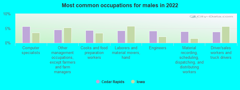
- Computer specialists (5.7%)
- Other management occupations, except farmers and farm managers (4.5%)
- Cooks and food preparation workers (4.3%)
- Laborers and material movers, hand (4.2%)
- Engineers (4.1%)
- Material recording, scheduling, dispatching, and distributing workers (3.9%)
- Driver/sales workers and truck drivers (3.8%)
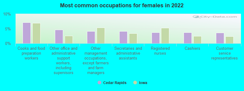
- Cooks and food preparation workers (7.1%)
- Other office and administrative support workers, including supervisors (4.6%)
- Other management occupations, except farmers and farm managers (4.2%)
- Secretaries and administrative assistants (4.1%)
- Registered nurses (3.8%)
- Cashiers (3.7%)
- Customer service representatives (3.6%)
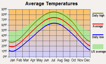
Average climate in Cedar Rapids, Iowa
Based on data reported by over 4,000 weather stations


|
|

(lower is better)
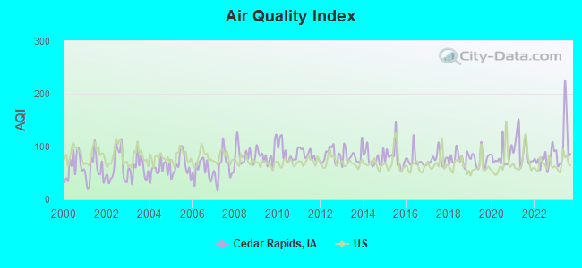
Air Quality Index (AQI) level in 2023 was 105. This is significantly worse than average.
| City: | 105 |
| U.S.: | 73 |
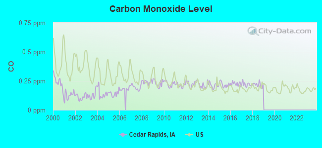
Carbon Monoxide (CO) [ppm] level in 2018 was 0.217. This is about average. Closest monitor was 0.2 miles away from the city center.
| City: | 0.217 |
| U.S.: | 0.251 |
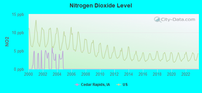
Nitrogen Dioxide (NO2) [ppb] level in 2004 was 3.43. This is significantly better than average. Closest monitor was 0.7 miles away from the city center.
| City: | 3.43 |
| U.S.: | 5.11 |

Sulfur Dioxide (SO2) [ppb] level in 2023 was 0.268. This is significantly better than average. Closest monitor was 0.3 miles away from the city center.
| City: | 0.268 |
| U.S.: | 1.515 |
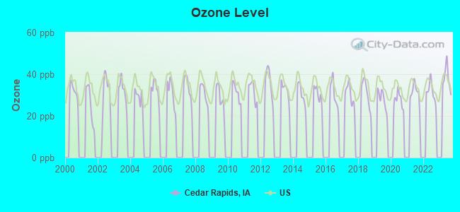
Ozone [ppb] level in 2023 was 38.0. This is about average. Closest monitor was 0.7 miles away from the city center.
| City: | 38.0 |
| U.S.: | 33.3 |
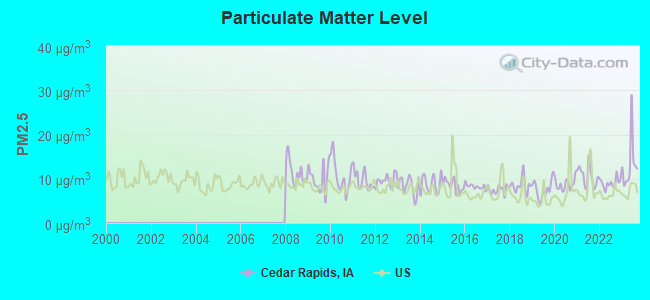
Particulate Matter (PM2.5) [µg/m3] level in 2023 was 13.2. This is significantly worse than average. Closest monitor was 1.1 miles away from the city center.
| City: | 13.2 |
| U.S.: | 8.1 |
Tornado activity:
Cedar Rapids-area historical tornado activity is near Iowa state average. It is 103% greater than the overall U.S. average.
On 4/30/1954, a category F4 (max. wind speeds 207-260 mph) tornado 9.1 miles away from the Cedar Rapids city center .
On 3/13/1990, a category F4 tornado 21.3 miles away from the city center caused between $5,000,000 and $50,000,000 in damages.
Earthquake activity:
Cedar Rapids-area historical earthquake activity is significantly above Iowa state average. It is 136% greater than the overall U.S. average.On 4/18/2008 at 09:36:59, a magnitude 5.4 (5.1 MB, 4.8 MS, 5.4 MW, 5.2 MW, Class: Moderate, Intensity: VI - VII) earthquake occurred 315.5 miles away from Cedar Rapids center
On 6/10/1987 at 23:48:54, a magnitude 5.1 (4.9 MB, 4.4 MS, 4.6 MS, 5.1 LG) earthquake occurred 295.8 miles away from Cedar Rapids center
On 4/18/2008 at 09:36:59, a magnitude 5.2 (5.2 MW, Depth: 8.9 mi) earthquake occurred 315.5 miles away from Cedar Rapids center
On 6/28/2004 at 06:10:52, a magnitude 4.2 (4.2 MW, Depth: 6.2 mi, Class: Light, Intensity: IV - V) earthquake occurred 147.4 miles away from Cedar Rapids center
On 6/18/2002 at 17:37:15, a magnitude 5.0 (4.3 MB, 4.6 MW, 5.0 LG) earthquake occurred 344.7 miles away from Cedar Rapids center
On 9/3/2016 at 12:02:44, a magnitude 5.8 (5.8 MW, Depth: 3.5 mi) earthquake occurred 476.5 miles away from the city center
Magnitude types: regional Lg-wave magnitude (LG), body-wave magnitude (MB), surface-wave magnitude (MS), moment magnitude (MW)
Natural disasters:
The number of natural disasters in Linn County (22) is greater than the US average (15).Major Disasters (Presidential) Declared: 20
Emergencies Declared: 1
Causes of natural disasters: Floods: 17, Storms: 14, Tornadoes: 6, Heavy Rains: 2, Winter Storms: 2, Hurricane: 1, Wind: 1, Other: 1 (Note: some incidents may be assigned to more than one category).
Main business address for: MCLEODUSA INC (RADIO TELEPHONE COMMUNICATIONS), POLAR MOLECULAR HOLDING CORP (MISCELLANEOUS CHEMICAL PRODUCTS), ROCKWELL COLLINS INC (AIRCRAFT PART & AUXILIARY EQUIPMENT, NEC), MACC PRIVATE EQUITIES INC , INTERSTATE POWER & LIGHT CO (ELECTRIC & OTHER SERVICES COMBINED), UNITED FIRE & CASUALTY CO (FIRE, MARINE & CASUALTY INSURANCE).
Hospitals in Cedar Rapids:
- AMENITY HOSPICE OF CEDAR RAPIDS (211 FIRST AVENUE SE)
- HOSPICE OF MERCY (2740 FIRST AVENUE NE)
- MERCY MEDICAL CENTER - CEDAR RAPIDS (Voluntary non-profit - Church, 701 10TH STREET SE)
- REM IOWA-36TH AVENUE (29 36TH AVENUE S W)
- REM IOWA-CRESTWOOD (3944 CRESTWOOD DRIVE N W)
- REM IOWA-MANSFIELD AVENUE (2901 MANSFIELD AVENUE)
- ST LUKES HOSPICE (1201 THIRD AVENUE SE)
- ST LUKES HOSPITAL (Voluntary non-profit - Private, 1026 A AVE NE)
- TANAGER PLACE (2309 C STREET SW)
Nursing Homes in Cedar Rapids:
- COTTAGE GROVE PLACE - THE CLUB (2115 FIRST AVENUE SE)
- HERITAGE NURSING AND REHAB CENTE (200 CLIVE DRIVE SW)
- LIVING CENTER WEST (1050 4TH AVENUE SE)
- MANORCARE HEALTH SERVICES (1940 FIRST AVENUE NE)
- MERCY MEDICAL CENTER (701 TENTH STREET SE)
- METH-WICK HEALTH CENTER (1224 13TH STREET NW)
- NORTHBROOK MANOR CARE CENTER (6420 COUNCIL STREET NE)
- WEST RIDGE CARE CENTER (3131 F AVENUE NW)
Dialysis Facilities in Cedar Rapids:
- MERCY MEDICAL CENTER - CEDAR RAPIDS (701 10TH ST SE)
- MERCY MEDICAL CENTER DIALYSIS - MERCY PLAZA (5264 COUNCIL ST NE SUITE 200)
Home Health Centers in Cedar Rapids:
- CAREPRO HOME HEALTH (402 TENTH STREET SE)
- COMFORT CARE MEDICARE INC (4027 GLASS ROAD NE)
- MERCY HOME HEALTH CARE (2740 FIRST AVENUE NE)
- RECOVER HEALTH OF IOWA, INC (1435 31ST STREET NE, SUITE A)
- RES CARE HOMECARE, IOWA (139 40TH STREET NE)
- THERAPY SOLUTIONS INC (3315 FIRST AVENUE SE)
- VISITING NURSES ASSOCIATION OF LINN COUNTY (600 BOYSON ROAD NE,SUITE 2)
Airports and heliports located in Cedar Rapids:
- The Eastern Iowa Airport (CID) (Runways: 2, Commercial Ops: 10,565, Air Taxi Ops: 15,252, Itinerant Ops: 15,792, Local Ops: 7,897, Military Ops: 403)
- Mercy Hospital Heliport (IA72)
- St Lukes Hospital Emergency Heliport (IA73)
Operable nuclear power plant near Cedar Rapids:
- 9 miles: Duane Arnold in Palo, IA.
Colleges/Universities in Cedar Rapids:
- Kirkwood Community College (Full-time enrollment: 11,503; Location: 6301 Kirkwood Blvd SW; Public; Website: www.kirkwood.edu)
- Coe College (Full-time enrollment: 1,504; Location: 1220 First Ave NE; Private, not-for-profit; Website: www.coe.edu; Offers Master's degree)
- Mount Mercy University (Full-time enrollment: 1,439; Location: 1330 Elmhurst Dr NE; Private, not-for-profit; Website: www.mtmercy.edu; Offers Master's degree)
- Kaplan University-Cedar Rapids Campus (Full-time enrollment: 1,022; Location: 3165 Edgewood Parkway SW; Private, for-profit; Website: www.kaplanuniversity.edu/cedar-rapids-iowa.aspx; Offers Master's degree)
- Capri College-Cedar Rapids (Full-time enrollment: 298; Location: 2945 Williams Parkway S.W.; Private, for-profit; Website: www.capricollege.edu)
- ITT Technical Institute-Cedar Rapids (Full-time enrollment: 83; Location: 3735 Queen Ct SW; Private, for-profit; Website: www.itt-tech.edu)
- Mercy-St Luke's School of Radiologic Technology (Full-time enrollment: 36; Location: 1026 A Ave NE; Private, not-for-profit; Website: www.isrt.org/ResourceCenter/mstl.aspx)
- American College of Hairstyling-Cedar Rapids (Full-time enrollment: 16; Location: 1531 First Ave SE; Private, for-profit; Website: americancollegeofhair.com)
Other colleges/universities with over 2000 students near Cedar Rapids:
- University of Iowa (about 24 miles; Iowa City, IA; Full-time enrollment: 24,735)
- Hawkeye Community College (about 46 miles; Waterloo, IA; FT enrollment: 7,160)
- University of Northern Iowa (about 55 miles; Cedar Falls, IA; FT enrollment: 10,816)
- Upper Iowa University (about 60 miles; Fayette, IA; FT enrollment: 5,275)
- Saint Ambrose University (about 64 miles; Davenport, IA; FT enrollment: 3,053)
- Eastern Iowa Community College District (about 65 miles; Davenport, IA; FT enrollment: 5,507)
- Kaplan University-Davenport Campus (about 65 miles; Davenport, IA; FT enrollment: 60,376)
Public high schools in Cedar Rapids:
- JOHN F KENNEDY HIGH SCHOOL (Students: 1,877, Location: 4545 WENIG RD NE, Grades: 9-12)
- GEORGE WASHINGTON HIGH SCHOOL (Students: 1,617, Location: 2205 FOREST DR SE, Grades: 9-12)
- THOMAS JEFFERSON HIGH SCHOOL (Students: 1,552, Location: 1243 20TH ST SW, Grades: 9-12)
- PRAIRIE HIGH SCHOOL (Students: 1,150, Location: 401 76TH AVE SW, Grades: 10-12)
- METRO HIGH SCHOOL (Students: 556, Location: 1212 7TH ST SE, Grades: 9-12)
- PRAIRIE EDGE (Students: 37, Location: 401 76TH AVE SW, Grades: KG-12)
- PRAIRIE POINT (Location: 8015 KIRKWOOD BLVD, Grades: 7-9)
Private high schools in Cedar Rapids:
- XAVIER HIGH SCHOOL (Students: 750, Location: 6300 42ND ST NE, Grades: 9-12)
- CEDAR VALLEY CHRISTIAN SCHOOL (Students: 219, Location: 3636 COTTAGE GROVE AVE SE, Grades: PK-12)
- TANAGER PLACE SCHOOL (Students: 22, Location: 2309 C ST SW, Grades: 3-11)
Biggest public elementary/middle schools in Cedar Rapids:
- HARDING MIDDLE SCHOOL (Students: 916, Location: 4801 GOLF ST NE, Grades: 6-8)
- PRAIRIE HILL ELEMENTARY SCHOOL (Students: 908, Location: 401 76TH AVENUE SW, Grades: PK-4)
- TAFT MIDDLE SCHOOL (Students: 708, Location: 5200 E AVE NW, Grades: 6-8)
- FRANKLIN MIDDLE SCHOOL (Students: 647, Location: 300 20TH ST NE, Grades: 6-8)
- ROOSEVELT MIDDLE SCHOOL (Students: 638, Location: 300 13TH ST NW, Grades: 6-8)
- MCKINLEY MIDDLE SCHOOL (Students: 613, Location: 620 10TH ST SE, Grades: 6-8)
- VIOLA GIBSON ELEMENTARY SCHOOL (Students: 538, Location: 6101 GIBSON DR NE, Grades: PK-5)
- WILSON MIDDLE SCHOOL (Students: 527, Location: 2301 J ST SW, Grades: 6-8)
- PRAIRIE RIDGE ELEMENTARY (Students: 503, Location: 401 76TH AVENUE SW, Grades: PK-4)
- PRAIRIE HEIGHTS ELEMENTARY SCHOOL (Students: 496, Location: 401 76TH AVE SW, Grades: PK-4)
Biggest private elementary/middle schools in Cedar Rapids:
- LASALLE MIDDLE SCHOOL - HOLY FAMILY (Students: 555, Location: 3700 1ST AVE NW, Grades: PK-8)
- REGIS MIDDLE SCHOOL (Students: 454, Location: 735 PRAIRIE DR NE, Grades: 6-8)
- ST PIUS X ELEMENTARY SCHOOL (Students: 397, Location: 4901 COUNCIL ST NE, Grades: KG-5)
- ALL SAINTS PARISH SCHOOL (Students: 291, Location: 720 29TH ST SE, Grades: PK-5)
- ST MATTHEW SCHOOL (Students: 279, Location: 2244 1ST AVE NE, Grades: PK-5)
- ISAAC NEWTON CHRISTIAN ACADEMY (Students: 230, Location: 1635 LINMAR DR NE, Grades: PK-8)
- TRINITY LUTHERAN SCHOOL (Students: 168, Location: 1361 7TH AVE SW, Grades: PK-8)
- SUMMIT SCHOOLS (Students: 140, Location: 1010 REGENT ST NE, Grades: PK-5)
- JN ANDREWS CHRISTIAN ACADEMY (Students: 19, Location: 2773 LOGGERHEAD RD, Grades: 1-7)
- GOOD SHEPHERD LUTHERAN SCHOOL (Students: 18, Location: 2900 42ND ST NE, Grades: KG-8)
User-submitted facts and corrections:
- Birthplace of Zach Johnson, PGA Tour
- Another private school is Cedar Valley Christian School in Cedar Rapids. 319-366-7462.
- Cedar Rapids is also the home of Zach Johnson, 2007 Masters Golf Champion, born 4/24/76. Also the correct address for Hamilton College is 3165 Edgewood Pkwy SW
- Zach Johnson Professional golfer on tour was born in Cedar Rapids, Iowa.
- AEGON USA is one of the largest employers in the city. AEGON is one of the Top 5 life companies in the world and is headquartered in the Hague in the Netherlands. Cedar Rapids is the primary center of U.S. operations with other offices in Louisville, KY; New York, NY; Los Angeles, CA; and executive offices in Baltimore, MD. AEGON is traded on the NYSE under the symbol AEG.
Points of interest:
Notable locations in Cedar Rapids: Konigsmark (A), Cedar Rapids (B), Czeck Village (C), Brucemore (D), Saint Andrews Golf Club (E), Veterans Memorial Tennis Center (F), Jones Park Golf Course (G), Indian Creek Nature Center (H), Ushers Ferry Historical Village (I), Ellis Golf Course (J), Cedar Rapids Country Club (K), Cedar Rapids South Bound Rest Area (L), Cedar Rapids North Bound Rest Area (M), Epley (N), Twin Pines Golf Course (O), J Avenue Water Plant (P), Bever Zoo (Q), Elmcrest Country Club (R), Hawkeye Downs (S), Cedar Rapids Fire Department Central Station (T). Display/hide their locations on the map
Shopping Centers: Plaza West Shopping Center (1), Mays Shopping Center (2), Westdale Mall (3), Town and Country Shopping Center (4), Northland Spuare Shopping Center (5), Lindale Plaza Shopping Center (6). Display/hide their locations on the map
Main business address in Cedar Rapids include: MCLEODUSA INC (A), POLAR MOLECULAR HOLDING CORP (B), ROCKWELL COLLINS INC (C), MACC PRIVATE EQUITIES INC (D), INTERSTATE POWER & LIGHT CO (E), UNITED FIRE & CASUALTY CO (F). Display/hide their locations on the map
Churches in Cedar Rapids include: Good Shepherd Church (A), Hope Church (B), Saint Ludmilas Church (C), New Life Church (D), Greek Orthodox Church (E), Grace Episcopal Church (F), Central Park Presbyterian Church (G), Salvation Army Church (H), Peace Christian Reformed Church (I). Display/hide their locations on the map
Cemeteries: Oak Hill Cemetery (1), Baker Cemetery (2), Bohemian Cemetery (3), Saint Johns Cemetery (4), Cedar Park Memorial Cemetery (5), Syrian Cemetery (6), Czech National Cemetery (7). Display/hide their locations on the map
Lakes: Robbins Lake (A), Cedar Lake (B). Display/hide their locations on the map
Streams, rivers, and creeks: Cold Stream (A), Prairie Creek (B), Willow Creek (C), Indian Creek (D). Display/hide their locations on the map
Parks in Cedar Rapids include: Alandale Park (1), Reed Park (2), Redmond Park (3), Anderson Park (4), Apache Park (5), Arrowhead Park (6), Riverside Park (7), Beaver Park (8), Sac and Fox Indian Trail Park (9). Display/hide their locations on the map
Tourist attractions: Grand Lodge of Iowa AF & Am (Museums; 813 1st Avenue Southeast) (1), Cedar Rapids Museum of Art (410 3rd Avenue Southeast) (2), Celebration Hall (Museums; 55 12th Avenue Southeast) (3), History Center (Museums; 615 1st Avenue Southeast) (4), African American Historical Mus & Cltrl Center of IWA (Museums; 55 12th Avenue Southeast) (5), Czech Village Association (Cultural Attractions- Events- & Facilities; 48 16th Avenue Southwest) (6), St Andrews Golf Course (Amusement & Theme Parks; 1866 Blairs Ferry Road Northeast) (7), Spacewalk of Cedar Rapids (Amusement & Theme Parks; 1000 Ellis Boulevard Northwest) (8), Planet X (Amusement & Theme Parks; 255 Collins Road Northeast) (9). Display/hide their approximate locations on the map
Hotels: Howard Johnson (9100 Atlantic Drive SW) (1), Marriott Cedar Rapids (1200 Collins Road Northeast) (2), Clarion Hotel & Convention Center (525 33rd Avenue Southwest) (3), Residence Inn Cedar Rapids (1900 Dodge Road Northeast) (4), Howard Johnson Airport Express Inn (9100 Atlantic Dr SW) (5), Best Western Longbranch Hotel (90 Twixt Town Road Northeast) (6), Windows Restaurant (350 1st Avenue Northeast) (7), Holiday Inn Express Fax Line (3320 Southgate Court Southwest) (8), Econo Lodge (622 33rd Avenue Southwest) (9). Display/hide their approximate locations on the map
Courts: Iowa State - Courts- District Court (50 3rd Avenue Bridge) (1), United States Government - Courts- District Court- Us Probation Office (101 1st Street Southeast) (2), United States Government - Courts- District Court (101 1st Street Southeast) (3), United States Government - Courts- Bankrupcy Court (425 2nd Street Southeast) (4), Iowa State - Courts- Juvenile Court Office (305 2nd Avenue Southeast) (5), Iowa State - Public Defender (215 4th Avenue Southeast) (6). Display/hide their approximate locations on the map
Birthplace of: Bobby Driscoll - Actor/Artist, Michael Emerson - Actor, Chris Carney - Politician, Joe Arenas - Recipient of the Purple Heart medal, Elijah Wood - (born 1981), actor, Ashton Kutcher - (born 1978), actor, Riley Smith - Film actor, Terry Farrell (actress) - Actress, Amy Sewell - Documentary filmmaker, Don DeFore - Actor.
Drinking water stations with addresses in Cedar Rapids and their reported violations in the past:
CEDAR RAPIDS WATER DEPARTMENT (Address: 761 J AVE NE , Population served: 128,201, Groundwater under infl of surface water):Past monitoring violations:CEDAR TERRACE MHC (Address: 9100 DEER RIDGE DR , Population served: 590, Purch groundwater under infl of surface water):
- Single Turbidity Exceed (Enhanced SWTR) - In DEC-2009, Contaminant: IESWTR. Follow-up actions: St Public Notif requested (DEC-22-2009), St Formal NOV issued (DEC-28-2009), St Public Notif received (JAN-19-2010), St Compliance achieved (JUL-07-2010)
- Single Turbidity Exceed (Enhanced SWTR) - In DEC-2009, Contaminant: IESWTR. Follow-up actions: St Public Notif requested (DEC-22-2009), St Formal NOV issued (DEC-22-2009), St Public Notif received (JAN-19-2010), St Compliance achieved (JUL-07-2010)
- Single Turbidity Exceed (Enhanced SWTR) - In MAR-2007, Contaminant: IESWTR. Follow-up actions: St Public Notif requested (MAR-02-2007), St Public Notif received (MAR-02-2007), St Formal NOV issued (MAR-02-2007), St Compliance achieved (OCT-11-2007)
Past monitoring violations:DEER RIDGE HOMEOWNERS WATER ASSC. (Address: 9422 DEER RIDGE DR , Population served: 94, Groundwater):
- Monitoring and Reporting (DBP) - In MAY-2013, Contaminant: Total Haloacetic Acids (HAA5). Follow-up actions: St Formal NOV issued (JUL-19-2013), St Public Notif requested (JUL-19-2013), St Public Notif received (JUL-31-2013), St Compliance achieved (AUG-28-2013)
- Monitoring and Reporting (DBP) - In MAY-2013, Contaminant: TTHM. Follow-up actions: St Public Notif requested (JUL-19-2013), St Formal NOV issued (JUL-19-2013), St Public Notif received (JUL-31-2013), St Compliance achieved (AUG-28-2013)
- Monitoring and Reporting (DBP) - Between APR-2006 and JUN-2006, Contaminant: Chlorine. Follow-up actions: St Public Notif received (JUN-01-2006), St Compliance achieved (JUN-01-2006), St Formal NOV issued (JUL-27-2006), St Public Notif requested (JUL-27-2006)
- Monitoring and Reporting (DBP) - Between JAN-2006 and MAR-2006, Contaminant: Chlorine. Follow-up actions: St Formal NOV issued (APR-24-2006), St Public Notif requested (APR-24-2006), St Public Notif received (JUN-01-2006), St Compliance achieved (JUN-01-2006)
- One routine major monitoring violation
Past health violations:BRITTANY ESTATES HOMEOWNERS ASSOCIATION (Address: 3092 BRITTANY CIRCLE , Population served: 72, Groundwater):
- MCL, Monthly (TCR) - In JUN-2010, Contaminant: Coliform. Follow-up actions: St Violation/Reminder Notice (JUN-03-2010), St Public Notif requested (JUN-17-2010), St Formal NOV issued (JUN-17-2010), St Public Notif received (JUN-28-2010), St Compliance achieved (DEC-02-2010)
- MCL, Monthly (TCR) - In JUN-2008, Contaminant: Coliform. Follow-up actions: St Violation/Reminder Notice (JUN-16-2008), St Formal NOV issued (JUN-24-2008), St Public Notif requested (JUN-24-2008), St Public Notif received (JUL-14-2008), St Compliance achieved (DEC-08-2008)
Past health violations:COACHLITE MOBILE HOME PARK (Serves WI, Population served: 70, Groundwater):
- MCL, Monthly (TCR) - In AUG-2013, Contaminant: Coliform. Follow-up actions: St Violation/Reminder Notice (AUG-16-2013), St Formal NOV issued (AUG-22-2013), St Public Notif requested (AUG-22-2013), St Public Notif received (SEP-03-2013), St Compliance achieved (SEP-24-2013)
- MCL, Monthly (TCR) - In FEB-2009, Contaminant: Coliform. Follow-up actions: St Violation/Reminder Notice (FEB-13-2009), St Formal NOV issued (FEB-23-2009), St Public Notif requested (FEB-23-2009), St Public Notif received (MAR-10-2009), St Compliance achieved (OCT-13-2009)
- MCL, Monthly (TCR) - In AUG-2005, Contaminant: Coliform. Follow-up actions: St Violation/Reminder Notice (AUG-31-2005), St Formal NOV issued (SEP-08-2005), St Public Notif requested (SEP-08-2005), St Compliance achieved (MAR-16-2006)
Past monitoring violations:FAIRVIEW TERRACE MOBILE HOME PARK LLC (Address: 4420 BOWLING ST SW H13 , Population served: 70, Groundwater):
- Lead Consumer Notice - In JAN-01-2013, Contaminant: Lead and Copper Rule. Follow-up actions: St Other (JAN-10-2013)
Past monitoring violations:LOYAL ORDER OF THE MOOSE LODGE/C RAPIDS (Address: 1820 W POST RD SW , Population served: 70, Groundwater):
- 2 minor monitoring violations
Past health violations:ROLLING ACRES GOLF COURSE (Address: 1526 MATTERHORN DR NE , Population served: 50, Groundwater):Past monitoring violations:
- MCL, Monthly (TCR) - Between APR-2014 and JUN-2014, Contaminant: Coliform. Follow-up actions: St Violation/Reminder Notice (JUN-16-2014), St Public Notif requested (JUN-25-2014), St Formal NOV issued (JUN-25-2014)
- Monitoring, Repeat Major (TCR) - Between JUL-2007 and OCT-2007, Contaminant: Coliform (TCR). Follow-up actions: St Formal NOV issued (NOV-28-2007), St Public Notif requested (NOV-28-2007), St Compliance achieved (FEB-07-2008)
- Monitoring, Repeat Major (TCR) - Between APR-2006 and JUL-2006, Contaminant: Coliform (TCR). Follow-up actions: St Public Notif requested (JUL-31-2006), St Formal NOV issued (JUL-31-2006), St Compliance achieved (NOV-07-2006)
- 11 routine major monitoring violations
Past health violations:Past monitoring violations:
- MCL, Monthly (TCR) - In MAY-2010, Contaminant: Coliform. Follow-up actions: St Formal NOV issued (MAY-28-2010), St Public Notif requested (MAY-28-2010), St Compliance achieved (OCT-25-2010)
- MCL, Monthly (TCR) - Between JUL-2008 and SEP-2008, Contaminant: Coliform. Follow-up actions: St Violation/Reminder Notice (OCT-02-2008), St Public Notif requested (OCT-23-2008), St Formal NOV issued (OCT-23-2008), St Public Notif received (NOV-12-2008), St Compliance achieved (JUN-30-2009)
- MCL, Monthly (TCR) - Between JUL-2007 and SEP-2007, Contaminant: Coliform. Follow-up actions: St Violation/Reminder Notice (AUG-07-2007), St Public Notif requested (AUG-21-2007), St Formal NOV issued (AUG-21-2007), St Public Notif received (APR-15-2008), St Compliance achieved (JUN-30-2008)
- MCL, Acute (TCR) - Between APR-2006 and JUN-2006, Contaminant: Coliform. Follow-up actions: St Formal NOV issued (JUL-05-2006), St Public Notif requested (JUL-05-2006), St Compliance achieved (JUN-12-2007)
- MCL, Monthly (TCR) - Between APR-2006 and JUN-2006, Contaminant: Coliform. Follow-up actions: St Formal NOV issued (JUL-05-2006), St Public Notif requested (JUL-05-2006), St Compliance achieved (JUN-12-2007)
- Monitoring, Repeat Major (TCR) - Between JUN-2011 and JUL-2011, Contaminant: Coliform (TCR). Follow-up actions: St Formal NOV issued (AUG-23-2011), St Public Notif requested (AUG-23-2011), St Compliance achieved (SEP-20-2011)
- Monitoring, Repeat Major (TCR) - Between JUL-2007 and AUG-2007, Contaminant: Coliform (TCR). Follow-up actions: St Formal NOV issued (SEP-24-2007), St Public Notif requested (SEP-24-2007), St Compliance achieved (OCT-01-2007), St Public Notif received (APR-15-2008)
- 11 routine major monitoring violations
- 6 regular monitoring violations
| This city: | 2.3 people |
| Iowa: | 2.4 people |
| This city: | 58.1% |
| Whole state: | 64.7% |
| This city: | 8.1% |
| Whole state: | 6.7% |
Likely homosexual households (counted as self-reported same-sex unmarried-partner households)
- Lesbian couples: 0.4% of all households
- Gay men: 0.3% of all households
People in group quarters in Cedar Rapids in 2010:
- 1,376 people in college/university student housing
- 769 people in nursing facilities/skilled-nursing facilities
- 311 people in local jails and other municipal confinement facilities
- 275 people in other noninstitutional facilities
- 181 people in residential treatment centers for juveniles (non-correctional)
- 171 people in correctional residential facilities
- 134 people in emergency and transitional shelters (with sleeping facilities) for people experiencing homelessness
- 101 people in group homes intended for adults
- 75 people in residential schools for people with disabilities
- 71 people in workers' group living quarters and job corps centers
- 42 people in in-patient hospice facilities
- 12 people in group homes for juveniles (non-correctional)
People in group quarters in Cedar Rapids in 2000:
- 1,265 people in college dormitories (includes college quarters off campus)
- 985 people in nursing homes
- 383 people in other noninstitutional group quarters
- 257 people in local jails and other confinement facilities (including police lockups)
- 142 people in halfway houses
- 86 people in homes for the mentally retarded
- 63 people in other group homes
- 60 people in homes for the mentally ill
- 51 people in religious group quarters
- 28 people in other nonhousehold living situations
- 26 people in homes for the physically handicapped
- 23 people in hospitals/wards and hospices for chronically ill
- 23 people in other hospitals or wards for chronically ill
Banks with most branches in Cedar Rapids (2011 data):
- U.S. Bank National Association: 8 branches. Info updated 2012/01/30: Bank assets: $330,470.8 mil, Deposits: $236,091.5 mil, headquarters in Cincinnati, OH, positive income, 3121 total offices, Holding Company: U.S. Bancorp
- Wells Fargo Bank, National Association: 7 branches. Info updated 2011/04/05: Bank assets: $1,161,490.0 mil, Deposits: $905,653.0 mil, headquarters in Sioux Falls, SD, positive income, 6395 total offices, Holding Company: Wells Fargo & Company
- Guaranty Bank and Trust Company: Bever Avenue Office, 42nd Street Branch, Wal*mart East Branch, Guaranty Bank And Trust Company, Cedar Hills Branch. Info updated 2006/11/03: Bank assets: $237.9 mil, Deposits: $189.5 mil, local headquarters, positive income, Commercial Lending Specialization, 7 total offices, Holding Company: Guaranty Bankshares, Ltd.
- Bank of the West: Cedar Rapids - Lindale, Cedar Rapids - North River Village, Cedar Rapids - Downtown, Cedar Rapids - Westdale. Info updated 2009/11/16: Bank assets: $62,408.3 mil, Deposits: $43,995.2 mil, headquarters in San Francisco, CA, positive income, 647 total offices, Holding Company: Bnp Paribas
- Bankers Trust Company: National Association, Mobile Branch, , National Association, at 221 Third Avenue, Southeast. Info updated 2010/01/13: Bank assets: $398.2 mil, Deposits: $285.7 mil, local headquarters, positive income, Commercial Lending Specialization, 3 total offices, Holding Company: Btc Financial Corporation
- Hills Bank and Trust Company: Southwest Cr Branch, Blairs Ferry Road Branch, Downtown Branch Cr. Info updated 2012/02/07: Bank assets: $2,018.3 mil, Deposits: $1,528.4 mil, headquarters in Hills, IA, positive income, Commercial Lending Specialization, 18 total offices, Holding Company: Hills Bancorporation
- Liberty Bank, F.S.B.: Council Street Branch at 5210 Council Street, Northeast, branch established on 2004/12/27; Cedar Rapids Branch at 320 3rd Street, Se, branch established on 2002/10/09. Info updated 2011/07/21: Bank assets: $934.1 mil, Deposits: $843.6 mil, headquarters in West Des Moines, IA, negative income in the last year, Commercial Lending Specialization, 27 total offices
- Farmers State Bank: Edgewood Road Branch at 399 Edgewood Road N.W., branch established on 1996/10/31; Van Buren Village Branch at 2755 Edgewood Road., S.W., branch established on 2001/11/19. Info updated 2006/11/03: Bank assets: $624.5 mil, Deposits: $526.5 mil, headquarters in Marion, IA, positive income, Commercial Lending Specialization, 8 total offices, Holding Company: Neighbor Insurance Agency, Inc.
- BankIowa of Cedar Rapids: Edgewood Parkway Branch at 2701 Edgewood Parkway, Sw, branch established on 2001/08/01; Bankiowa Of Cedar Rapids at 7045 C Avenue Northeast, branch established on 1881/01/01. Info updated 2006/11/03: Bank assets: $464.4 mil, Deposits: $375.8 mil, local headquarters, positive income, Commercial Lending Specialization, 11 total offices, Holding Company: Fidelity Ban Corporation
- 5 other banks with 7 local branches
For population 15 years and over in Cedar Rapids:
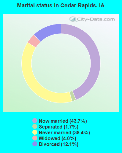
- Never married: 38.4%
- Now married: 43.7%
- Separated: 1.7%
- Widowed: 4.0%
- Divorced: 12.1%
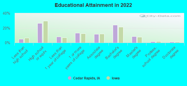
For population 25 years and over in Cedar Rapids:
- High school or higher: 95.0%
- Bachelor's degree or higher: 35.5%
- Graduate or professional degree: 11.3%
- Unemployed: 4.0%
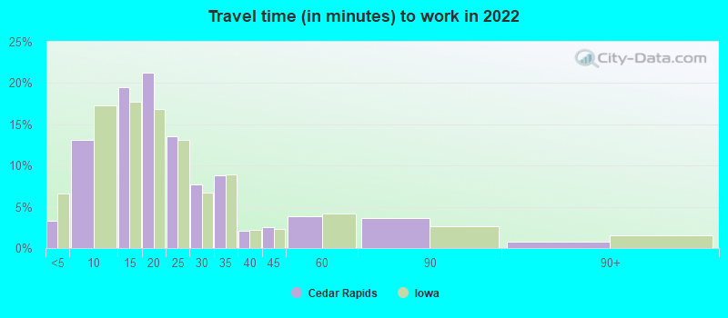
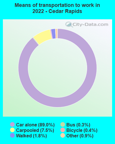
- Mean travel time to work (commute): 15.6 minutes
| Here: | 9.3 |
| Iowa average: | 10.5 |
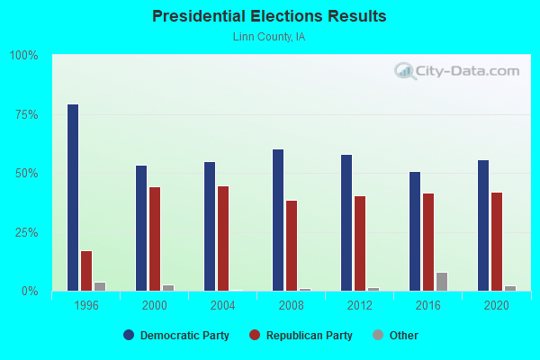
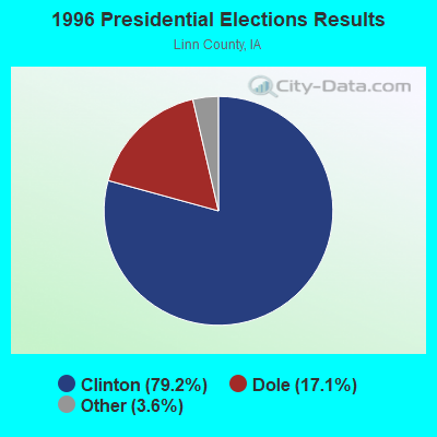
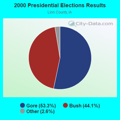
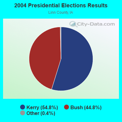
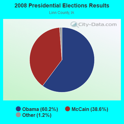
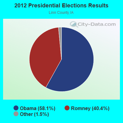
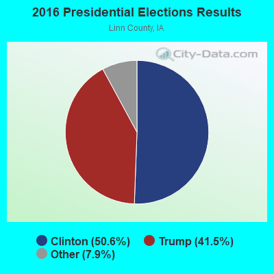

Graphs represent county-level data. Detailed 2008 Election Results
Neighborhoods in Cedar Rapids:
(Cedar Rapids, Iowa Neighborhood Map)Religion statistics for Cedar Rapids, IA (based on Linn County data)
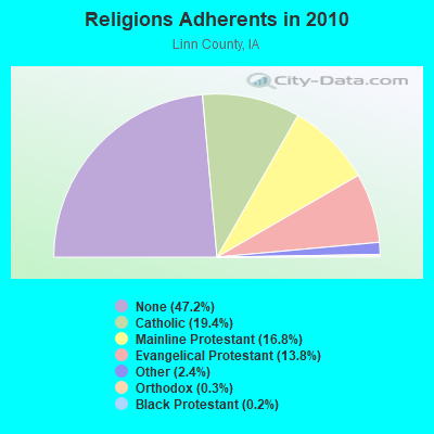
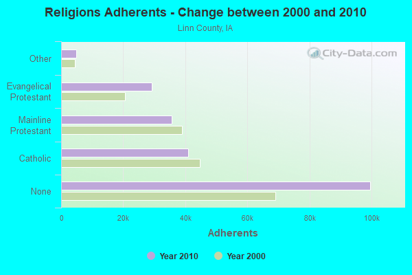
| Religion | Adherents | Congregations |
|---|---|---|
| Catholic | 40,930 | 18 |
| Mainline Protestant | 35,522 | 75 |
| Evangelical Protestant | 29,184 | 88 |
| Other | 4,969 | 18 |
| Orthodox | 545 | 2 |
| Black Protestant | 433 | 2 |
| None | 99,643 | - |
Food Environment Statistics:
| Here: | 1.31 / 10,000 pop. |
| State: | 2.14 / 10,000 pop. |
| Here: | 0.24 / 10,000 pop. |
| State: | 0.23 / 10,000 pop. |
| This county: | 0.15 / 10,000 pop. |
| State: | 0.43 / 10,000 pop. |
| This county: | 4.28 / 10,000 pop. |
| Iowa: | 5.55 / 10,000 pop. |
| Linn County: | 7.10 / 10,000 pop. |
| Iowa: | 8.01 / 10,000 pop. |
| Linn County: | 7.2% |
| Iowa: | 7.8% |
| Here: | 28.6% |
| Iowa: | 27.3% |
| Linn County: | 13.4% |
| Iowa: | 14.5% |
Health and Nutrition:
| This city: | 51.0% |
| Iowa: | 49.5% |
| Here: | 48.7% |
| Iowa: | 46.1% |
| Here: | 28.5 |
| State: | 28.6 |
| Here: | 20.1% |
| Iowa: | 21.4% |
| Here: | 10.2% |
| Iowa: | 10.4% |
| Cedar Rapids: | 6.9 |
| Iowa: | 6.8 |
| Cedar Rapids: | 33.4% |
| State: | 33.8% |
| Here: | 58.2% |
| Iowa: | 55.9% |
| This city: | 79.3% |
| Iowa: | 77.7% |
More about Health and Nutrition of Cedar Rapids, IA Residents
| Local government employment and payroll (March 2022) | |||||
| Function | Full-time employees | Monthly full-time payroll | Average yearly full-time wage | Part-time employees | Monthly part-time payroll |
|---|---|---|---|---|---|
| Police Protection - Officers | 219 | $1,683,269 | $92,234 | 0 | $0 |
| Streets and Highways | 157 | $921,548 | $70,437 | 1 | $3,176 |
| Firefighters | 141 | $1,051,325 | $89,474 | 0 | $0 |
| Sewerage | 112 | $670,889 | $71,881 | 1 | $1,594 |
| Water Supply | 107 | $646,943 | $72,554 | 0 | $0 |
| Other and Unallocable | 73 | $396,244 | $65,136 | 0 | $0 |
| Financial Administration | 70 | $459,066 | $78,697 | 1 | $3,572 |
| Transit | 57 | $289,653 | $60,980 | 0 | $0 |
| Police - Other | 56 | $294,965 | $63,207 | 0 | $0 |
| Solid Waste Management | 48 | $240,717 | $60,179 | 0 | $0 |
| Parks and Recreation | 48 | $278,812 | $69,703 | 69 | $32,408 |
| Other Government Administration | 45 | $322,354 | $85,961 | 9 | $17,663 |
| Airports | 43 | $264,749 | $73,883 | 12 | $8,660 |
| Fire - Other | 41 | $238,846 | $69,906 | 0 | $0 |
| Local Libraries | 41 | $233,857 | $68,446 | 43 | $93,022 |
| Housing and Community Development (Local) | 13 | $67,438 | $62,250 | 0 | $0 |
| Natural Resources | 11 | $55,751 | $60,819 | 0 | $0 |
| Health | 10 | $46,427 | $55,712 | 0 | $0 |
| Judicial and Legal | 6 | $55,951 | $111,902 | 0 | $0 |
| Totals for Government | 1,298 | $8,218,804 | $75,983 | 136 | $160,096 |
Cedar Rapids government finances - Expenditure in 2021 (per resident):
- Construction - General - Other: $58,072,000 ($425.66)
Natural Resources - Other: $31,724,000 ($232.53)
Air Transportation: $23,116,000 ($169.44)
Sewerage: $10,492,000 ($76.90)
Water Utilities: $9,994,000 ($73.25)
Parking Facilities: $516,000 ($3.78)
- Current Operations - General - Other: $125,498,000 ($919.88)
Police Protection: $48,133,000 ($352.81)
Sewerage: $28,741,000 ($210.67)
Regular Highways: $23,023,000 ($168.75)
Local Fire Protection: $21,996,000 ($161.23)
Water Utilities: $21,669,000 ($158.83)
Parks and Recreation: $11,296,000 ($82.80)
Solid Waste Management: $11,064,000 ($81.10)
Air Transportation: $10,561,000 ($77.41)
Transit Utilities: $9,138,000 ($66.98)
Libraries: $7,090,000 ($51.97)
Housing and Community Development: $6,922,000 ($50.74)
Financial Administration: $6,202,000 ($45.46)
Protective Inspection and Regulation - Other: $3,754,000 ($27.52)
Central Staff Services: $3,496,000 ($25.63)
Health - Other: $1,361,000 ($9.98)
General Public Buildings: $1,180,000 ($8.65)
Judicial and Legal Services: $962,000 ($7.05)
Parking Facilities: $188,000 ($1.38)
- General - Interest on Debt: $11,175,000 ($81.91)
- Other Capital Outlay - General - Other: $3,140,000 ($23.02)
Transit Utilities: $272,000 ($1.99)
- Total Salaries and Wages: $100,644,000 ($737.70)
- Water Utilities - Interest on Debt: $3,192,000 ($23.40)
Cedar Rapids government finances - Revenue in 2021 (per resident):
- Charges - Sewerage: $57,540,000 ($421.76)
Other: $26,329,000 ($192.99)
Parks and Recreation: $18,159,000 ($133.10)
Air Transportation: $14,390,000 ($105.48)
Solid Waste Management: $12,351,000 ($90.53)
Housing and Community Development: $453,000 ($3.32)
Parking Facilities: $437,000 ($3.20)
Regular Highways: $61,000 ($0.45)
- Federal Intergovernmental - Air Transportation: $14,475,000 ($106.10)
Other: $9,312,000 ($68.26)
Housing and Community Development: $9,103,000 ($66.72)
Transit Utilities: $6,548,000 ($48.00)
Natural Resources: $954,000 ($6.99)
Public Welfare: $295,000 ($2.16)
- Local Intergovernmental - Other: $728,000 ($5.34)
- Miscellaneous - Fines and Forfeits: $13,311,000 ($97.57)
General Revenue - Other: $8,937,000 ($65.51)
Interest Earnings: $2,420,000 ($17.74)
Special Assessments: $1,893,000 ($13.88)
Sale of Property: $989,000 ($7.25)
Rents: $610,000 ($4.47)
- Revenue - Water Utilities: $38,877,000 ($284.96)
Transit Utilities: $233,000 ($1.71)
- State Intergovernmental - Highways: $19,811,000 ($145.21)
Other: $16,545,000 ($121.27)
General Local Government Support: $4,104,000 ($30.08)
- Tax - Property: $121,307,000 ($889.16)
General Sales and Gross Receipts: $24,196,000 ($177.35)
Public Utilities Sales: $14,354,000 ($105.21)
Other License: $4,157,000 ($30.47)
Other Selective Sales: $3,145,000 ($23.05)
Cedar Rapids government finances - Debt in 2021 (per resident):
- Long Term Debt - Outstanding Unspecified Public Purpose: $476,899,000 ($3495.58)
Beginning Outstanding - Unspecified Public Purpose: $451,596,000 ($3310.12)
Issue, Unspecified Public Purpose: $96,164,000 ($704.86)
Retired Unspecified Public Purpose: $70,861,000 ($519.40)
Beginning Outstanding - Public Debt for Private Purpose: $56,000,000 ($410.47)
Outstanding Nonguaranteed - Industrial Revenue: $52,620,000 ($385.70)
Retired Nonguaranteed - Public Debt for Private Purpose: $3,380,000 ($24.77)
Cedar Rapids government finances - Cash and Securities in 2021 (per resident):
- Bond Funds - Cash and Securities: $73,046,000 ($535.41)
- Other Funds - Cash and Securities: $448,863,000 ($3290.08)
- Sinking Funds - Cash and Securities: $68,337,000 ($500.90)
| Businesses in Cedar Rapids, IA | ||||
| Name | Count | Name | Count | |
|---|---|---|---|---|
| ALDI | 2 | Lane Bryant | 1 | |
| AT&T | 2 | Lane Furniture | 3 | |
| Ace Hardware | 1 | LensCrafters | 2 | |
| Advance Auto Parts | 2 | Little Caesars Pizza | 3 | |
| Aeropostale | 1 | Long John Silver's | 2 | |
| AmericInn | 1 | Lowe's | 1 | |
| American Eagle Outfitters | 1 | MainStay | 1 | |
| Applebee's | 2 | Marriott | 2 | |
| Arby's | 4 | MasterBrand Cabinets | 20 | |
| Ashley Furniture | 1 | Maurices | 2 | |
| AutoZone | 3 | Mazda | 1 | |
| BMW | 1 | McDonald's | 6 | |
| Barnes & Noble | 1 | Men's Wearhouse | 1 | |
| Bath & Body Works | 2 | Menards | 1 | |
| Baymont Inn | 1 | Motel 6 | 1 | |
| Bed Bath & Beyond | 1 | Motherhood Maternity | 1 | |
| Best Western | 2 | New Balance | 2 | |
| Blockbuster | 2 | Nike | 11 | |
| Budget Car Rental | 1 | Nissan | 1 | |
| Buffalo Wild Wings | 2 | OfficeMax | 1 | |
| Burger King | 5 | Old Navy | 1 | |
| CVS | 2 | Olive Garden | 1 | |
| Carson Pirie Scott | 2 | Outback | 1 | |
| Chevrolet | 1 | Outback Steakhouse | 1 | |
| Chick-Fil-A | 1 | Panda Express | 1 | |
| Chuck E. Cheese's | 1 | Panera Bread | 2 | |
| Clarion | 1 | Papa John's Pizza | 2 | |
| Cold Stone Creamery | 2 | Payless | 2 | |
| Comfort Inn | 2 | Penske | 1 | |
| Curves | 1 | PetSmart | 1 | |
| DHL | 4 | Pizza Hut | 6 | |
| Dairy Queen | 6 | Plato's Closet | 1 | |
| Days Inn | 1 | Quality | 1 | |
| Deb | 1 | Quiznos | 3 | |
| Decora Cabinetry | 3 | RadioShack | 2 | |
| Domino's Pizza | 2 | Red Lobster | 1 | |
| DressBarn | 1 | Red Robin | 1 | |
| Dressbarn | 1 | Red Roof Inn | 1 | |
| Econo Lodge | 1 | Rodeway Inn | 1 | |
| Eddie Bauer | 1 | Ruby Tuesday | 2 | |
| Ethan Allen | 1 | Rue21 | 1 | |
| Express | 1 | Ryan's Grill | 1 | |
| Famous Footwear | 3 | Ryder Rental & Truck Leasing | 1 | |
| FedEx | 33 | SAS Shoes | 1 | |
| Finish Line | 2 | SONIC Drive-In | 2 | |
| Firestone Complete Auto Care | 2 | Sam's Club | 1 | |
| Foot Locker | 1 | Sears | 2 | |
| Ford | 1 | Slumberland | 1 | |
| GNC | 3 | Spencer Gifts | 1 | |
| GameStop | 3 | Sprint Nextel | 4 | |
| Goodwill | 2 | Staples | 2 | |
| H&R Block | 6 | Starbucks | 6 | |
| Hardee's | 5 | Subaru | 1 | |
| Hawthorn | 1 | Subway | 13 | |
| Hilton | 1 | Super 8 | 2 | |
| Holiday Inn | 3 | T.J.Maxx | 1 | |
| Home Depot | 1 | Taco Bell | 4 | |
| Honda | 1 | Talbots | 1 | |
| Hot Topic | 1 | Target | 2 | |
| Howard Johnson | 1 | Toys"R"Us | 1 | |
| Hyundai | 1 | True Value | 2 | |
| IHOP | 1 | U-Haul | 3 | |
| JCPenney | 1 | U.S. Cellular | 5 | |
| Jimmy John's | 2 | UPS | 40 | |
| Jones New York | 4 | Vans | 2 | |
| Journeys | 1 | Verizon Wireless | 2 | |
| Justice | 1 | Victoria's Secret | 1 | |
| KFC | 3 | Village Inn | 1 | |
| Kmart | 2 | Walgreens | 4 | |
| Kohl's | 1 | Walmart | 2 | |
| Kroger | 4 | Wendy's | 6 | |
| La-Z-Boy | 2 | YMCA | 3 | |
Strongest AM radio stations in Cedar Rapids:
- WMT (600 AM; 5 kW; CEDAR RAPIDS, IA; Owner: CITICASTERS LICENSES, L.P.)
- KMRY (1450 AM; 1 kW; CEDAR RAPIDS, IA; Owner: SELLERS BROADCASTING, INC.)
- KCRG (1600 AM; 5 kW; CEDAR RAPIDS, IA; Owner: CEDAR RAPIDS TELEVISION CO.)
- KMJM (1360 AM; 1 kW; CEDAR RAPIDS, IA; Owner: CAPSTAR TX LIMITED PARTNERSHIP)
- KXEL (1540 AM; 50 kW; WATERLOO, IA; Owner: KXEL BROADCASTING COMPANY, INC.)
- KCJJ (1630 AM; 10 kW; IOWA CITY, IA; Owner: RIVER CITY RADIO, INC.)
- WHO (1040 AM; 50 kW; DES MOINES, IA; Owner: CITICASTERS LICENSES, L.P.)
- WSUI (910 AM; 5 kW; IOWA CITY, IA; Owner: THE UNIVERSITY OF IOWA)
- KXIC (800 AM; 1 kW; IOWA CITY, IA; Owner: CITICASTERS LICENSES, L.P.)
- KDNZ (1650 AM; 10 kW; CEDAR FALLS, IA; Owner: FIFE COMMUNICATIONS CO., LLC)
- KCNZ (1250 AM; 10 kW; CEDAR FALLS, IA; Owner: FIFE COMMUNICATION COMPANY, L.C.)
- KKHQ (950 AM; 5 kW; OELWEIN, IA; Owner: CUMULUS LICENSING CORP.)
- WTMJ (620 AM; 50 kW; MILWAUKEE, WI; Owner: JOURNAL BROADCAST CORPORATION)
Strongest FM radio stations in Cedar Rapids:
- WMT-FM (96.5 FM; CEDAR RAPIDS, IA; Owner: CITICASTERS LICENSES, L.P.)
- KDAT (104.5 FM; CEDAR RAPIDS, IA; Owner: CUMULUS LICENSING CORP.)
- KZIA (102.9 FM; CEDAR RAPIDS, IA; Owner: KZIA, INC.)
- KHAK (98.1 FM; CEDAR RAPIDS, IA; Owner: CUMULUS LICENSING CORP.)
- KCCK-FM (88.3 FM; CEDAR RAPIDS, IA; Owner: KIRKWOOD COMMUNITY COLLEGE)
- KUNI (90.9 FM; CEDAR FALLS, IA; Owner: UNIVERSITY OF NORTHERN IOWA)
- KRNA (94.1 FM; IOWA CITY, IA; Owner: CUMULUS LICENSING CORP.)
- KFMW (107.9 FM; WATERLOO, IA; Owner: KXEL BROADCASTING COMPANY, INC.)
- KSUI (91.7 FM; IOWA CITY, IA; Owner: THE UNIVERSITY OF IOWA)
- KKRQ (100.7 FM; IOWA CITY, IA; Owner: CITICASTERS LICENSES, L.P.)
- KOKZ (105.7 FM; WATERLOO, IA; Owner: KXEL BROADCASTING COMPANY, INC.)
- KOEL-FM (92.3 FM; OELWEIN, IA; Owner: CUMULUS LICENSING CORP.)
- KNWS-FM (101.9 FM; WATERLOO, IA; Owner: NORTHWESTERN COLLEGE)
- KRNL-FM (89.7 FM; MOUNT VERNON, IA; Owner: CORNELL COLLEGE)
- K236AA (95.1 FM; CEDAR RAPIDS, IA; Owner: FAMILY STATIONS, INC.)
- K261CA (100.1 FM; CEDAR RAPIDS, IA; Owner: POWER DU PREE BROADCASTING COMPANY)
TV broadcast stations around Cedar Rapids:
- KFXA (Channel 28; CEDAR RAPIDS, IA; Owner: SECOND GENERATION OF IOWA, LTD.)
- K17ET (Channel 17; CEDAR RAPIDS, IA; Owner: TRINITY BROADCASTING NETWORK)
- KCDE-LP (Channel 67; CEDAR RAPIDS, IA; Owner: TIGER EYE BROADCASTING CORPORATION)
- KCDR-LP (Channel 55; CEDAR RAPIDS, IA; Owner: TIGER EYE BROADCASTING CORPORATION)
- KHHH-LP (Channel 57; CEDAR RAPIDS, IA; Owner: TIGER EYE BROADCASTING CORPORATION)
- KRUB-LP (Channel 65; CEDAR RAPIDS, IA; Owner: TIGER EYE BROADCASTING CORPORATION)
- KGAN (Channel 2; CEDAR RAPIDS, IA; Owner: KGAN LICENSEE, LLC)
- KCRG-TV (Channel 9; CEDAR RAPIDS, IA; Owner: CEDAR RAPIDS TELEVISION CO.)
- KWWL (Channel 7; WATERLOO, IA; Owner: RAYCOM AMERICA, INC.)
- KRIN (Channel 32; WATERLOO, IA; Owner: IOWA PUBLIC BROADCASTING BOARD)
- KWKB (Channel 20; IOWA CITY, IA; Owner: KM TELEVISION OF IOWA, L.L.C.)
- KIIN (Channel 12; IOWA CITY, IA; Owner: IOWA PUBLIC BROADCASTING BOARD)
- KPXR (Channel 48; CEDAR RAPIDS, IA; Owner: PAXSON COMMUNICATIONS LICENSE COMPANY, LLC)
- K64DG (Channel 64; IOWA CITY, IA; Owner: R B SHELDAHL)
- National Bridge Inventory (NBI) Statistics
- 276Number of bridges
- 5,814ft / 1,772mTotal length
- 2,733,298Total average daily traffic
- 288,202Total average daily truck traffic
- New bridges - historical statistics
- 2Before 1900
- 21900-1909
- 11910-1919
- 11920-1929
- 51930-1939
- 21940-1949
- 41950-1959
- 121960-1969
- 1221970-1979
- 591980-1989
- 91990-1999
- 162000-2009
- 412010-2019
FCC Registered Antenna Towers: 340 (See the full list of FCC Registered Antenna Towers)
FCC Registered Commercial Land Mobile Towers: 8 (See the full list of FCC Registered Commercial Land Mobile Towers in Cedar Rapids, IA)
FCC Registered Private Land Mobile Towers: 7 (See the full list of FCC Registered Private Land Mobile Towers)
FCC Registered Broadcast Land Mobile Towers: 147 (See the full list of FCC Registered Broadcast Land Mobile Towers)
FCC Registered Microwave Towers: 205 (See the full list of FCC Registered Microwave Towers in this town)
FCC Registered Paging Towers: 18 (See the full list of FCC Registered Paging Towers)
FCC Registered Maritime Coast & Aviation Ground Towers: 35 (See the full list of FCC Registered Maritime Coast & Aviation Ground Towers)
FCC Registered Amateur Radio Licenses: 1,057 (See the full list of FCC Registered Amateur Radio Licenses in Cedar Rapids)
FAA Registered Aircraft Manufacturers and Dealers: 1 (See the full list of FAA Registered Manufacturers and Dealers in Cedar Rapids)
FAA Registered Aircraft: 160 (See the full list of FAA Registered Aircraft)
| Home Mortgage Disclosure Act Aggregated Statistics For Year 2009 (Based on 18 full and 11 partial tracts) | ||||||||||||||
| A) FHA, FSA/RHS & VA Home Purchase Loans | B) Conventional Home Purchase Loans | C) Refinancings | D) Home Improvement Loans | E) Loans on Dwellings For 5+ Families | F) Non-occupant Loans on < 5 Family Dwellings (A B C & D) | G) Loans On Manufactured Home Dwelling (A B C & D) | ||||||||
|---|---|---|---|---|---|---|---|---|---|---|---|---|---|---|
| Number | Average Value | Number | Average Value | Number | Average Value | Number | Average Value | Number | Average Value | Number | Average Value | Number | Average Value | |
| LOANS ORIGINATED | 703 | $114,051 | 1,165 | $110,434 | 2,346 | $129,573 | 234 | $33,681 | 18 | $1,256,367 | 302 | $81,949 | 15 | $32,595 |
| APPLICATIONS APPROVED, NOT ACCEPTED | 32 | $110,240 | 89 | $106,781 | 236 | $119,558 | 23 | $33,989 | 1 | $96,230 | 11 | $76,593 | 4 | $36,352 |
| APPLICATIONS DENIED | 77 | $112,707 | 104 | $99,006 | 533 | $112,353 | 100 | $26,281 | 1 | $608,000 | 33 | $67,837 | 24 | $24,978 |
| APPLICATIONS WITHDRAWN | 53 | $101,603 | 100 | $125,673 | 499 | $120,312 | 27 | $47,509 | 0 | $0 | 18 | $58,989 | 1 | $54,190 |
| FILES CLOSED FOR INCOMPLETENESS | 15 | $103,862 | 17 | $85,654 | 100 | $120,010 | 13 | $70,174 | 0 | $0 | 5 | $67,490 | 1 | $37,220 |
Detailed mortgage data for all 29 tracts in Cedar Rapids, IA
| Private Mortgage Insurance Companies Aggregated Statistics For Year 2009 (Based on 17 full and 11 partial tracts) | ||||||
| A) Conventional Home Purchase Loans | B) Refinancings | C) Non-occupant Loans on < 5 Family Dwellings (A & B) | ||||
|---|---|---|---|---|---|---|
| Number | Average Value | Number | Average Value | Number | Average Value | |
| LOANS ORIGINATED | 238 | $126,182 | 193 | $142,277 | 3 | $101,770 |
| APPLICATIONS APPROVED, NOT ACCEPTED | 33 | $122,558 | 29 | $132,446 | 4 | $69,865 |
| APPLICATIONS DENIED | 11 | $134,332 | 17 | $131,485 | 0 | $0 |
| APPLICATIONS WITHDRAWN | 6 | $110,802 | 14 | $156,562 | 0 | $0 |
| FILES CLOSED FOR INCOMPLETENESS | 6 | $127,462 | 1 | $235,030 | 0 | $0 |
2002 - 2018 National Fire Incident Reporting System (NFIRS) incidents
- Fire incident types reported to NFIRS in Cedar Rapids, IA
- 2,20345.5%Structure Fires
- 1,55032.0%Outside Fires
- 91919.0%Mobile Property/Vehicle Fires
- 1663.4%Other
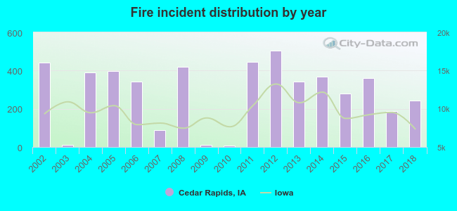 Based on the data from the years 2002 - 2018 the average number of fires per year is 285. The highest number of fire incidents - 503 took place in 2012, and the least - 6 in 2010. The data has a dropping trend.
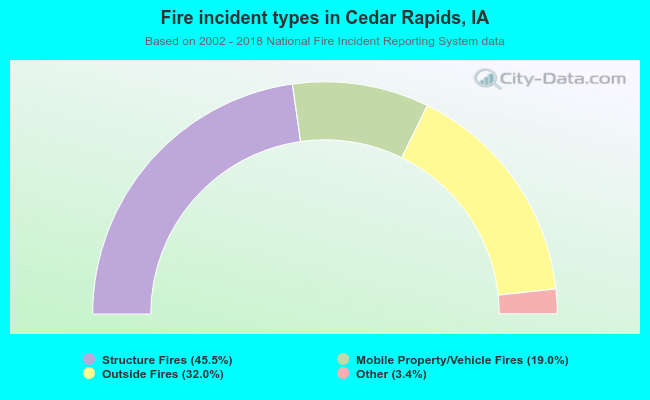 When looking into fire subcategories, the most reports belonged to: Structure Fires (45.5%), and Outside Fires (32.0%).
Fire-safe hotels and motels in Cedar Rapids, Iowa:
- Cedar Rapids Marriott, 1200 Collins Rd NE, Cedar Rapids, Iowa 52402 , Phone: (319) 393-6600, Fax: (319) 393-2308
- Quality Inn South, 390 33rd Ave SW, Cedar Rapids, Iowa 52404 , Phone: (319) 363-7934, Fax: (319) 363-7934
- Redroof Inn Cedar Rapids, 3243 Southridge Dr SW, Cedar Rapids, Iowa 52404 , Phone: (319) 364-2000, Fax: (319) 364-4620
- Heartland Inn, 3315 Southgate Ct SW, Cedar Rapids, Iowa 52404 , Phone: (319) 362-9012, Fax: (319) 362-9694
- Ramada Hotel & Convention Center, 525 33RD Ave SW, Cedar Rapids, Iowa 52406 , Phone: (319) 366-8671, Fax: (319) 362-1420
- Comfort Inn North, 5055 Rockwell Dr NE, Cedar Rapids, Iowa 52402 , Phone: (319) 393-8247, Fax: (319) 393-8247
- Best Western Longbranch Hotel, 90 Twixt Town Rd NE, Cedar Rapids, Iowa 52402 , Phone: (319) 377-6386, Fax: (319) 377-6386
- Hampton Inn Cedar Rapids, 3265 6TH St SW, Cedar Rapids, Iowa 52404 , Phone: (319) 364-8144, Fax: (319) 399-1877
- 23 other hotels and motels
| Most common first names in Cedar Rapids, IA among deceased individuals | ||
| Name | Count | Lived (average) |
|---|---|---|
| Mary | 846 | 80.4 years |
| John | 783 | 75.7 years |
| Robert | 659 | 72.2 years |
| William | 618 | 75.9 years |
| Charles | 527 | 76.3 years |
| James | 489 | 72.4 years |
| Helen | 443 | 81.4 years |
| George | 442 | 77.3 years |
| Joseph | 387 | 78.5 years |
| Margaret | 350 | 80.8 years |
| Most common last names in Cedar Rapids, IA among deceased individuals | ||
| Last name | Count | Lived (average) |
|---|---|---|
| Smith | 265 | 75.4 years |
| Johnson | 256 | 77.7 years |
| Miller | 210 | 77.6 years |
| Brown | 150 | 77.1 years |
| Jones | 142 | 75.6 years |
| Anderson | 130 | 76.5 years |
| Wilson | 121 | 74.6 years |
| Thompson | 116 | 78.0 years |
| Williams | 115 | 73.5 years |
| Nelson | 110 | 77.2 years |
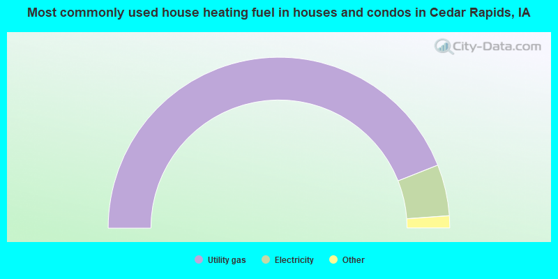
- 88.1%Utility gas
- 9.7%Electricity
- 1.8%Bottled, tank, or LP gas
- 0.2%No fuel used
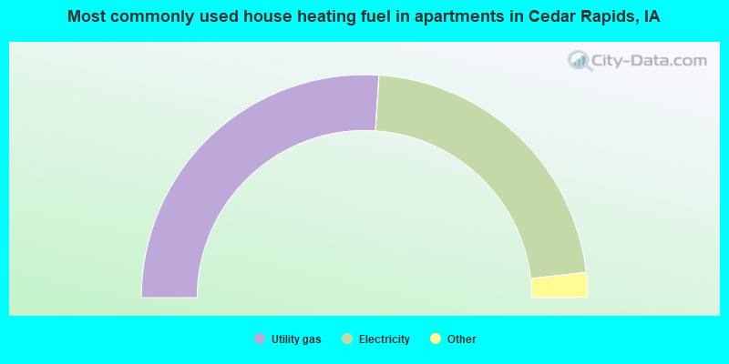
- 53.5%Utility gas
- 42.8%Electricity
- 1.5%Bottled, tank, or LP gas
- 1.3%Other fuel
- 0.8%No fuel used
Cedar Rapids compared to Iowa state average:
- Unemployed percentage significantly below state average.
- Black race population percentage above state average.
- Median age significantly below state average.
- Length of stay since moving in below state average.
- Percentage of population with a bachelor's degree or higher above state average.
Cedar Rapids on our top lists:
- #24 on the list of "Top 101 cities with the highest percentage of English-only speaking households, population 50,000+"
- #28 on the list of "Top 101 cities with the largest wind speed differences during a year (population 50,000+)"
- #34 on the list of "Top 101 cities with the largest temperature differences during a year (population 50,000+)"
- #41 on the list of "Top 101 cities with the coldest winters (population 50,000+)"
- #41 on the list of "Top 101 cities with the lowest daily low temperatures (population 50,000+)"
- #43 on the list of "Top 101 cities with the lowest cost per building permit (population 50,000+)"
- #57 on the list of "Top 101 cities with largest percentage of females in industries: manufacturing (population 50,000+)"
- #61 on the list of "Top 101 cities with largest percentage of females in occupations: production occupations (population 50,000+)"
- #63 on the list of "Top 101 cities with largest percentage of females in industries: retail trade (population 50,000+)"
- #73 on the list of "Top 101 cities with largest percentage of males in industries: manufacturing (population 50,000+)"
- #92 on the list of "Top 101 cities with the highest average humidity (population 50,000+)"
- #92 on the list of "Top 101 cities with the most people born in the same U.S. state as the city (population 50,000+)"
- #96 on the list of "Top 100 least racially diverse cities (pop. 50,000+)"
- #99 on the list of "Top 101 cities with the largest percentage of people in halfway houses (population 1,000+)"
- #99 on the list of "Top 100 cities with shortest commuting times (pop. 50,000+)"
- #100 on the list of "Top 101 cities with largest percentage of males in occupations: office and administrative support occupations (population 50,000+)"
- #101 on the list of "Top 101 cities with largest percentage of males in occupations: farming, fishing, and forestry occupations (population 50,000+)"
- #101 on the list of "Top 101 cities with largest percentage of females in industries: administrative and support and waste management services (population 50,000+)"
- #34 (52411) on the list of "Top 101 zip codes with the largest percentage of Czech first ancestries (pop 5,000+)"
- #76 (52411) on the list of "Top 101 zip codes with the largest percentage of taxpayers reporting taxable interest in 2012 (pop 5,000+)"
- #16 on the list of "Top 101 counties with the highest percentage of residents that drank alcohol in the past 30 days"
- #26 on the list of "Top 101 counties with the highest carbon monoxide air pollution readings in 2012 (ppm)"
- #41 on the list of "Top 101 counties with the highest percentage of residents that visited a dentist within the past year"
- #61 on the list of "Top 101 counties with the highest ground withdrawal of fresh water for public supply"
- #78 on the list of "Top 101 counties with the highest Particulate Matter (PM10) Annual air pollution readings in 2012 (µg/m3)"
State forum archive:

|
|
Total of 930 patent applications in 2008-2024.