Please register to participate in our discussions with 2 million other members - it's free and quick! Some forums can only be seen by registered members. After you create your account, you'll be able to customize options and access all our 15,000 new posts/day with fewer ads.
No where in Georgia is at 30 degrees North Latitude, and definitely not 30 degrees south latitude. 30 degrees NORTH latitude goes roughly through Jacksonville, Florida. If this line touches any of Georgia, it is the little tip created by the St. Mary's River.
Atlanta is at roughly 34 N latitude. Lake Lanier is at roughly 35 N latitude.
By the way, not all places are a desert at 30 N latitude.
If you check this out, parts of China and south Asia are anything but a desert.
Lake Lanier is not at 35 N latitude. 35 N latitude is the dividing line between the TN/NC and GA border. Also, extreme south GA is right around 30 N, maybe not exactly 30 N but very close.
Lake Lanier is not at 35 N latitude. 35 N latitude is the dividing line between the TN/NC and GA border. Also, extreme south GA is right around 30 N, maybe not exactly 30 N but very close.
But still he is pretty much right...roughly speaking. Lake Lanier and the watershed basin feeding into is located at approximately 34.14 degrees at Buford Dam and north close to the state line just short of 35th parallel.
But either way...what is important to understand.... the latitude is ultimately a red herring argument.
We are a humid, subtropical environment. It is measurable and there is no immediate risk of it turning into an arid environment.
The large continental mass to the west and north generates heat from the sun hitting land....hot air rises and creates low pressure and pulls in humid air from the coasts. It is a textbook case of what happens on the southeastern section or a large continental land mass.
Even Jacksonville, Fl, which is close to 30 degrees is no where near an arid environment or is threatened into being turned into one.
Don't get me wrong we need to be concerned with human effects on the environment and climate change for the long-run and for a variety of reasons, but there is nothing currently threatening to turn out humid climate into an arid. If there was a change that drastic it will occur over a veeeery long time period that is beyond what we need to be concerned with long-term regional planning.
Looks like GA is going back to court to appeal the water ruling. Even the judge stated the decision was "draconian". This is what I don't understand:
1. Although the water flows south to Alabama and Florida, the water is still as much ours as it originates here. Yeah, we need to be conscious of those downstream who also need it, but it was a rare drought. No matter what the water would have been lower.
2. The Army Corps of Engineers always let us use the lake for water usage and let us take out more water as we grew, so how is GA "stealing"? It's not like we can just take it without their permission. They should have never let us use it if they were going to one day decide to cut it off.
Even if they rule against us, again, they should at least give us a longer time period to figure this out. This isn't something that can be quickly and easily fixed. If anyone is at fault, it is the Army Corps of Engineers for ALLOWING us to use the lake for water usage.
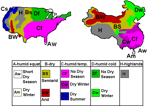
The closest climatic approximation to the United States in the world is China. It has almost the exact same latitudinal extent; the only think China lacks is a west coast which here in the United States has no bearing on the climate on the Southeast. So the Southeastern United States is under no threat of desertification...based on what? Your opinion? Please read below.
Drought Turns Southern China into Arid Plain (http://solveclimate.com/news/20100408/drought-turns-southern-china-arid-plain - broken link)
Southeastern China is actually wetter than the Southeastern United States; they certainly have the precipitation to grow more rice than Louisiana and South Carolina ever could. Desertification is neither slow nor impossible and surprise, in our latitude is directly correlated to overdevelopment and the damming of rivers!
Quote:
Originally Posted by cwkimbro
But still he is pretty much right...roughly speaking. Lake Lanier and the watershed basin feeding into is located at approximately 34.14 degrees at Buford Dam and north close to the state line just short of 35th parallel.
But either way...what is important to understand.... the latitude is ultimately a red herring argument.
We are a humid, subtropical environment. It is measurable and there is no immediate risk of it turning into an arid environment.
The large continental mass to the west and north generates heat from the sun hitting land....hot air rises and creates low pressure and pulls in humid air from the coasts. It is a textbook case of what happens on the southeastern section or a large continental land mass.
Even Jacksonville, Fl, which is close to 30 degrees is no where near an arid environment or is threatened into being turned into one.
Don't get me wrong we need to be concerned with human effects on the environment and climate change for the long-run and for a variety of reasons, but there is nothing currently threatening to turn out humid climate into an arid. If there was a change that drastic it will occur over a veeeery long time period that is beyond what we need to be concerned with long-term regional planning.
Last edited by Steelers10; 03-06-2011 at 11:50 AM..
That one falls into the "If it happens, we're all screwed anyways" category for me personally. We're talking tens of millions dead in the Sahel, Europe-turns-into-Siberia type of monumental change that will engluf the whole world; changes that will spare no human.
Yes, Atlanta will be in a lot of trouble if that's the case.
The closest climatic approximation to the United States in the world is China. It has almost the exact same latitudinal extent; the only think China lacks is a west coast which here in the United States has no bearing on the climate on the Southeast. So the Southeastern United States is under no threat of desertification...based on what? Your opinion? Please read below.
Drought Turns Southern China into Arid Plain (http://solveclimate.com/news/20100408/drought-turns-southern-china-arid-plain - broken link)
Southeastern China is actually wetter than the Southeastern United States; they certainly have the precipitation to grow more rice than Louisiana and South Carolina ever could. Desertification is neither slow nor impossible and surprise, in our latitude is directly correlated to overdevelopment and the damming of rivers!
So I am guessing your opinion is that the Southeastern US is going to turn into a desert climate by 2040??
Looks like GA is going back to court to appeal the water ruling. Even the judge stated the decision was "draconian". This is what I don't understand:
1. Although the water flows south to Alabama and Florida, the water is still as much ours as it originates here. Yeah, we need to be conscious of those downstream who also need it, but it was a rare drought. No matter what the water would have been lower.
2. The Army Corps of Engineers always let us use the lake for water usage and let us take out more water as we grew, so how is GA "stealing"? It's not like we can just take it without their permission. They should have never let us use it if they were going to one day decide to cut it off.
Even if they rule against us, again, they should at least give us a longer time period to figure this out. This isn't something that can be quickly and easily fixed. If anyone is at fault, it is the Army Corps of Engineers for ALLOWING us to use the lake for water usage.
First as the article mentioned there are some reasons to believe the judge got this ruling wrong.
That aside... You're right. To reinforce those key points and add to them and provide issues for discussion....
-The ruling doesn't apply on our access to water, but water stored by Lanier.
-Long-term if this sticks for Atlanta... Alabama in particular (and other states throughout the south) need to be careful. We have federally built and funded dam systems like this everywhere in the south. If the city of Atlanta proper can't withdrawl water from the Chattahoochee during a drought, because it will cause Lake Lanier to have to discharge more water to make it into the Gulf....who is to say that any other the other downstream use within the basin (that isn't navigation, flood control, and hydroelectric generation) should be allowed? If local towns and farmers withdrawl water from a smaller river that flows into the Chattahoochee that would require the federal reservoir system to discharge more water. We haven't made these arguments, because it would harm both states (and potentially more). However, in the long-run they will hold true if the judge's ruling stands. We aren't the only ones in this situation... for the long-run. All downstream communities have been living off that constant-flow, and this includes non-hydroelectric power stations, rural farmers, and municipal water who haven't built their own reservoir systems with full storage.
-If the ruling stands Lake Lanier's presence alone is partially in the way of us building and storing water upstream of Lake Lanier. This is in no small part why the federally run reservoirs has always supported our local needs. A medium-run strategy we might have to face is the sue the federal government for taking too much water from the upper 5% of the Chattahoochee Basin preventing us from being able to access and store it. (That is why the ARC spots out that Lake Lanier stores 60% of the federal systems water, but only from the upper 5% of the basin)
-The ruling doesn't provide us adequate time to engineer and build any alternatives. The ruling was structured to anticipate a negotiated settlement or an act of congress to step in so long-term solutions can be maintained. The problem with this is... it puts all the pressure on Georgia and none on Alabama and Florida. (hince the reason Florida refuses to negotiate and Alabama has been fickle about it)
Litigation aside.... looking at how much water we use... but importantly how we use it
I, particularly, want to draw attention to the Waste water plan more so than the Water Supply Plan.
When we use water for municipal purposes it doesn't just disappear... it goes somewhere and most of it makes it's way back into the stream. It is the difference between what we take out and what we return that really reflects what we used. In the area we return 78% directly to the river from waste water treatment facilities and under drought restrictions (with watering restrictions) we have the ability to return more.
For each gallon we return to the river... that is one less gallon that needs to be released from Buford Dam to meet river flow requirements (and one more gallon saved for future municipal water storage).
So lets quickly examine where the other 22% goes
-evaporation
-groundwater recharge into groundwater supply.
-or groundwater flow back into the stream system itself (so that 22% is actually lower, but parts of it can't be directly measured. Because it can't be measured well, we can't easily measure interbasin transfers caused by groundwater flows from septic tanks, etc..)
How does that 22% get to one of those three conditions, instead of the other 78%...
consumptive water uses
(also, make an effort to consider for each consumptive use... does it increase evaporation? evaporation through plant use? does it make its way to ground water recharge areas? does it make its way back into streams indirectly?)
-10% of our water use is treated by septic systems (about 20% of residents have septic systems)
-Outside watering - car wash, lawn care
-Golf courses are large water consumers
-outdoor water features ~swimming pools, fountains, etc..
-industrial cooling, which leads to evaporation.
-agricultural irrigation
Now lets keep in mind... during most years and most months there is more than enough water for these consumptive water uses w/o problem. It is also why during a drought the first requirements that go into affect are consumptive use restrictions. Outdoor watering bans.
(side argument: we should consider making a plan that would restrict -some- industrial consumptive uses and car washing uses during extreme droughts. If a business knows about it ahead of time long before a drought happens, then a well run business can operate effectively and mitigate/manage those risks [aka we might end up paying 30 cents more for a car wash now, so a car wash doesn't go out of business when they can't operate during a long drought])
Other things we have done is regulate consumptive water use. New car wash facilities are better treating and reusing water on site, blowing water off a car before it leaves a building, etc... It is still consumptive water use, but it is lessened. For outdoor water features, they can be redesigned to have smaller profiles and limit evaporation. During a drought the consumptive water use from municipal water is replacing what evaporates. We also deter industrial facilities that are particularly high consumptive water users (alot of this is done through increasing water rates as consumptive use increases). The irony of this.... doing so sends them to places like rural Alabama where there are no statewide water use plans.
-Septic system-
There is a double edge sword here. For most counties when they start growing septic systems are too costly, but this is a significant source of consumptive use. In reality alot of water treated by septic systems is returned to streams indirectly. However, this is not directly measured and alot of water taken from the Coosa Basin flows into septic systems at lower elevations in the Chattahoochee Basin. Alot of water from the Chattahoochee Basin flows to septic systems in the Ocmulgee Basin. Septic systems are usually located in places where it is the most expensive to run, maintain, and operate sewer mains. There is a good arguments that not all of the water going through septic systems are truly consumptive, but it can't be measured on a day-to-day basis during droughts.
Ultimately... we probably need to go further to map out where septic systems are... Figure out if they are located in 1) a ground water supply recharge area or 2) an area where the groundwater flows back into the stream system. Note which stream systems. Examine how much water is evaporated through plants and surface overflows and how much makes its way into streams. It might be more important to retrofit-sewers in some places than others. We also need to be able to make better arguments and say we are reliably sure x% of septic treated water is making its way into this basin.
-Interbasin Transfers-
Atlanta puts back 78% of its water use directly back into the rivers. We put exactly 78% back into the Chattahoochee as well. There really isn't much of an interbasin transfer problem for the Chattahoochee itself. The problem occurs with a transfer from the Coosa (lake Altoona) being treated and put into the Chattahoochee and a near equal amount of water being taken from the Chattahoochee and being treated into the Yellow River/Ocmulgee Basin. Poltically, this isn't lost on Alabama.
The Coosa Basin is what flows close to Birmingham, serves Montgomery and much of south central Alabama.
The Ocmulgee Basin serves Macon, much of central and southern Georgia (including farmers, industrial uses, and nuclear power plants) Nuclear power plants have a high consumptive use as alot of water used is evaporated from cooling towers.
Ultimately, the interbasin tranfer occurs from the Coosa to the Ocmulgee (even though it is an indirect 2-step process). This has been okayed in the past in part that the Ocmulgee basin doesn't have as much dam control as the Coosa basin. This helps the Ocmulgee maintain river flows without more federal reservoirs, but at the expense of water in the Coosa.
I mention this, because at the heart of this issue isn't just Atlanta vs everyone as some people want to make it seem. Large parts of central and south Georgia are involved on this (and in many ways benefit from Atlanta), whether people understand/know it or not. There are also indirect effects on the Oconee basin. The Oconee and the Ocmulgee both flow into the Altamaha and into the Atlantic. (so in a sense Atlanta isn't competing with south Georgia and actually helps many in South Georgia indirectly)
I write this trying to point to issues at hand. The importance of how we use the water and where it goes is key in most of the arguments we have with with Alabama and Florida. They are also key in crafting the policies we grow by.
(For example.. we have one problem growing in Paulding County where about 99% of residents are on septic. We should consider requiring sewers for all exurban growth, since the cost of later retrofitting to sewer is much higher. This might also mean we need to craft laws that force larger neighboring counties to share negotiated use of waste treatment plants for a limited amount of growth and a limited amount of time. We can also examine if septic tanks are used... where is the best place for them to be used appropriately.)
As far as Lake Lanier and the Chattahoochee goes... beyond looking at how we use and treat water... worries about it running dry need to be taken into consideration how water is discharged. If we have a 3-year drought again... the Army Corp of engineers really needs to consider lowering river levels sooner. The drought wasn't Atlanta's fault. If they use Lake Lanier up until it is empty (if the drought continued for another year). Then the flows to Florida would have started to dry up. They need to be honest with themselves and say... that wasn't just Atlanta taking up all of the water. If the drought continued that river flow couldn't have been sustained. At what point do we lower river flows to maintain lower, but constant flows longer. Both Florida and Alabama's stance have ignored this and focused on blaming Atlanta, which isn't entirely the case. Most of the water stored in Lanier isn't used for our water supply, even today, and is released for flow down river. If we built a reservoir just for ourselves... it wouldn't need to be near that large.
Well, I think I have said my piece. Although applying it in the other direction, I think cwkimbro made the most accurate description of these statements when he mentioned "red herring". No one is forced to read any of the articles or links posted in these forums, but a smidge of intellectual curiosity prior to posting would be fantastic. If you had bothered to read the article about Southern China, you would find that in a climate and topography identical to Atlanta (see the low rise mountains in the background) a drought combined with too much water diversion via increased dam building and consumption of water due to overdevelopment desert conditions can occur.
Then someone made an absolutely ridiculous, petulant statement of "We're talking tens of millions dead in the Sahel, Europe-turns-into-Siberia type of monumental change that will engluf the whole world; changes that will spare no human."
Yeah that is pretty funny and glib on your part. Is Europe Siberia right now? No, but portions of Southern China are turning into a desert. So folks, these changes don't occur globally, nor do they take a long time. But whatever, I have said what I need to say on the matter. So I guess continue to cross your fingers that a drought like the one that occurred in 2007 will never happen despite droughts in Georgia occurring in 10 to 25-year cycles. cwkimbro eschews local news and wants an "academic" paper. So here it goes:
Another important contributing factor to the current drought in Georgia is the fact that Atlanta is a large city with limited water resources available. Metropolitan Atlanta depends on both Lake Alatoona and Lake Lanier for almost eighty percent of its water supply. Since construction of the Lake Lanier reservoir in the 1950s, the population of Atlanta has quadrupled and pressure has increased on what limited water is available in the reservoir.
The metro Atlanta area consists of twenty counties covering an area of nearly 6,100 square miles. Atlanta is #1 in the twenty most land-consuming metropolitan areas, ranked by land area developed between 1982 and 1997.
A study was conducted in which researchers calculated the amount of rainwater that runs off the land instead of filtering through groundwater resources, comparing the year 1997 versus 1982. Results found that the potential amount of water not infiltrated in Atlanta was 56.9 billion gallons to 132.8 billion gallons. Atlanta's losses in 1997 amounted to enough water to supply the average daily household needs of 1.5 million to 3.6 million people per year. Since the area has continued to see a steady increase in development since the study conducted in 1997, one can only assume that the amount of water not infiltrated today is even more than that eleven years ago.
So congratulations. Droughts are naturally occurring and in turn exacerbated by Atlanta's urban sprawl. But I strongly encourage you all to read the entire article. Please by all means just don't take my word for it because I'm just making up conspiracies as to why Atlanta was down to a 90-day water supply back in 2007. Gee, I wonder what would happen under the exact same drought conditions but with 3 million more people. I may check back in on this forum but I think I have said enough and will just continue to post this article. In doing anything else, I will be involved in some weird process of helping individuals cope with their state of denial as they employ the use of slippery slope fallacies.
Please register to post and access all features of our very popular forum. It is free and quick. Over $68,000 in prizes has already been given out to active posters on our forum. Additional giveaways are planned.
Detailed information about all U.S. cities, counties, and zip codes on our site: City-data.com.

 Please register to participate in our discussions with 2 million other members - it's free and quick! Some forums can only be seen by registered members. After you create your account, you'll be able to customize options and access all our 15,000 new posts/day with fewer ads.