Please register to participate in our discussions with 2 million other members - it's free and quick! Some forums can only be seen by registered members. After you create your account, you'll be able to customize options and access all our 15,000 new posts/day with fewer ads.
While expanding high-capacity rail transit service to Stone Mountain seems to be comparatively much more plausible of an idea (but unfortunately still an extremely heavy, if not nearly impossible lift at this point in time), extending the Stone Mountain Freeway into the city by tunneling it under the US-23/29/78 Scott Boulevard and US-23/29/78/278 Ponce De Leon Avenue corridors between the current western terminus of the US-78 Stone Mountain Freeway and the current eastern terminus of Freedom Parkway at US-23 Moreland Avenue, does not at all seem to be a bad idea.
It’s just that extending the Stone Mountain Freeway into the city through a tunnel under the Scott Boulevard corridor does not seem to be a politically plausible idea in such a politically progressive area with much affluence that has a notable history of successfully fighting off and defeating large-scale highway construction proposals that local residents don’t like.
The political leaders of the jurisdictions that such a tunneled superhighway would be proposed to run under (the mayors of Atlanta proper and Decatur proper, and the CEO of DeKalb County along with the state legislators that represent the area in both chambers of the Georgia Legislature) most likely (if not most assuredly) would not support such a highly controversial highway construction project.
And the federal politicians who represent the area (including Georgia 5th District Congresswoman Nikema Williams, Georgia 4th District Congressman Hank Johnson, Georgia US Senator Jon Ossoff (who is from DeKalb County) and Georgia US Senator Raphael Warnock (who is from Atlanta), including if he were to win re-election to the US Senate) likely would work to block all federal funding for the road if it were to need any federal funding.
I contend that Moreland Ave US23 is one of the most vital workhorses of any intown road.
It moves thousands of commuters every morning and afternoon and I wish the leaders in that jurisdiction could get it completely overhauled for better safety for both cars and pedestrians. Little 5 Points gor some pavement fixes but it's a long thoroughfare and is very bumpy South of I-20.
Born2 Roll knows so much about these elected powers that be all over the metro. I wish we could have an easy to read list of these offificals then everyone could copy them on our thoughts and suggestions.
Hey you never know what could be just a request away from seeing action!
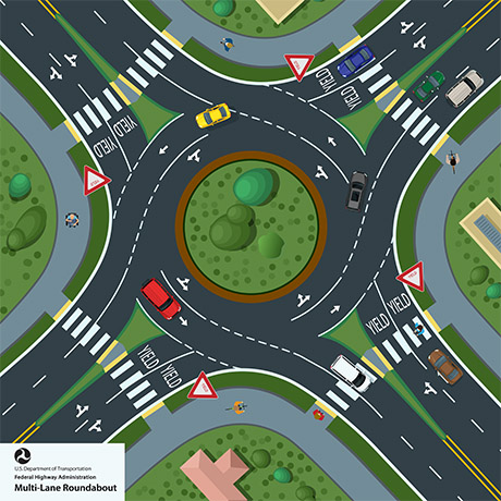
No left turns, no stop signs, no red lights, no stopping a whole line of cars just to wait around for a green light. Constant, efficient traffic flow 24/7. And much safer and fewer fatalities, too.
Even without grade separations, if Metro Atlanta replaced most of its intersections with roundabouts, traffic would flow a lot better.
And diverging diamonds at the freeway interchanges. Those are really good too, and much safer, with only 2 traffic lights.
If those freeways had been built, we still would've had the same congestion, only with more intown neighborhoods getting decimated for the benefit of suburban commuters.
That's not the City of Atlanta's problem.
A metro must decide how big it wants to ideally be and then build the adequate amount of road capacity to support it while maintaining a reasonable quality of life (i.e. not spending 1-2 hours a day in your car stuck in traffic)
I agree that freeways intown might be used by suburbs-residing commuters, however they supply the educated workforce just like intown residents that lures in growth and industries and high salaries.
Without those millions of OTP residents your home values and assets and salary would be lower and you wouldn't have international status as a place to be,
It's all indirectly connected to your and everyone's else's worth and bottom line.
No left turns, no stop signs, no red lights, no stopping a whole line of cars just to wait around for a green light. Constant, efficient traffic flow 24/7. And much safer and fewer fatalities, too.
Even without grade separations, if Metro Atlanta replaced most of its intersections with roundabouts, traffic would flow a lot better.
And diverging diamonds at the freeway interchanges. Those are really good too, and much safer, with only 2 traffic lights.
I do like the evolution into using traffic circles and DDIs.
Traffic circles with more than one lane can get dicey though for people to navigate.
No no B2R, I'm not suggesting some huge mega-expensive tunneling project through DeKalb for that route. I'm basically just saying, convert the existing Scott Blvd into a Stone Mountain Parkway (if not Freeway), by eliminating all the traffic lights on it between Ponce and 285, via upgrades such as grade separations at the major road intersections, consolidating some of the other intersections and eliminating left turns (maybe have a new small side street as like a collector/distributor), and maybe a couple of big UK-style roundabouts in the mix as well.
And then maybe a big roundabout at East Lake Rd, and that gets you as far west as roughly Fernbank, as basically a parkway with minimal intersection delays. And then the question is just how to connect the last ~2 miles or so, into Freedom Parkway.
Maybe some tunneling, maybe some road upgrading/grade separating/roundabouts, whatever would be feasible I guess.
But what should be feasible is making it all one (to some degree) free-flowing road corridor, and rename it all to one thing. Like call it the John Lewis Parkway, from the Connector all the way to Snellville or whatever.
And OTP in Gwinnett you would have 78/John Lewis Parkway have a grade separation at Scenic Highway and such.
Proposing to turn US-23/29/78 Scott Boulevard/Lawrenceville Highway into a largely grade-separated free-flowing parkway-style freeway with maybe a collector/distributor side street between Ponce De Leon Avenue and the US-78 Stone Mountain Freeway junction very likely (if not most assuredly) would be even less well-received and even less viable than a proposal for a tunneled expressway along and under that corridor.
The problem with that particular corridor (US-23/29/78 Scott Boulevard/Lawrenceville Highway between Ponce De Leon Avenue and the Stone Mountain Freeway junction) is the heavy amount of established residential development (including an elementary school and many mature trees) along the Scott Boulevard portion of the corridor (including many mature homes along Scott Boulevard itself).
The substantial amount of existing business commercial development along the upper part of the Scott Boulevard/Lawrenceville Highway corridor (between Eastland Drive and the Stone Mtn. Freeway junction) also would be a major obstacle to conversion of the Scott Boulevard corridor to a parkway-style freeway.
Though, the biggest obstacle to the conversion of the Scott Blvd corridor to a parkway-style freeway would be fierce public opposition to such a plan in an area where there is a very notable history of successful opposition to unpopular large-scale freeway construction proposals.
Attempting to name a new freeway-type road after the late Congressman John Lewis probably also likely would not be received all that well in a part of the metro area where Congressman Lewis fought against construction of a controversial parkway-style freeway proposal (the Presidential Parkway that was the precursor to what eventually became Freedom Parkway) when he was on the Atlanta City Council back in the 1980’s.
Constructing some grade separated intersections at busy junctions along the Gwinnett County portion of the US-78 (Stone Mountain Highway/Main Street) corridor is a good idea.
Though, it probably should be noted that the Gwinnett County portion of the US-78 corridor recently was upgraded (and made exponentially safer) from the east end of the Stone Mountain Freeway out to just east of the Georgia 124 junction where a major traffic improvement was installed in the form of displaced left-turn lanes from both directions of US-78 to GA-124.
... So with the recent significant safety and traffic flow improvements made to the Gwinnett County portion of the US-78 corridor from the east end of the Stone Mountain Freeway out to the GA-124 junction, the Georgia Department of Transportation very likely would be extremely hesitant to want to attempt to spend anymore money attempting to make more upgrades to a road that also is lined with a very heavy amount of tax revenue-generating commercial development.
Quote:
Originally Posted by primaltech
Another big one to do would be 141/Peachtree Pkwy, which runs halfway between 400 and I-85, through the suburbs of Peachtree Corners and Johns Creek, out into Forsyth County.
Similar type idea, I think. Key grade separations at the big intersections (like at Holcomb Bridge/Spalding/State Bridge), and elimination of other smaller intersections (basically seek to eliminate all the traffic lights along 141 out to where it connects to 400 in Forsyth, and do a proper freeway interchange there).
Then you'd have like a whole new semi-freeway for the northeast suburbs, even if it's not to interstate-standards. The portion between Holcomb Bridge and the Perimeter already exists.
Quote:
Originally Posted by primaltech
Have Peachtree Parkway start right here at the Buckhead Village triangle:
It would run through Buckhead/Brookhaven/Chamblee as an upgraded version of the existing Peachtree Rd, with the goal being of having no traffic signal intersections. Just a series of key roundabouts and grade separations, where feasible.
The end result being a free-flowing parkway from Buckhead to Cumming, taking some of the traffic pressure off of both 400 and I-85. Even if it would have generally lower speeds than either of those. It wouldn't need to be an interstate.
I like the idea of installing grade separated intersections at busy junctions along the Georgia State Route 141 Peachtree Parkway/Medlock Bridge Road/Peachtree Parkway corridor between the Peachtree Industrial Boulevard split in Peachtree Corners and the Georgia State Route 400 junction in Cumming.
Though, eliminating smaller intersections likely wouldn’t be possible because of the large and meaningful amount of commercial development closely lining the Georgia 141 corridor.
Converting Georgia 141 Peachtree Road/Peachtree Boulevard to a free-flowing parkway through extremely heavily developed ITP communities like Buckhead, Brookhaven and Chamblee very likely wouldn’t be possible because of the extremely heavy amount of existing development lining the urban roadway (especially through the Buckhead commercial district).
I do like the evolution into using traffic circles and DDIs.
Traffic circles with more than one lane can get dicey though for people to navigate.
Clear signage/ road markers/ arrows help, and always following the 2 basic rules, that you should never change lanes while in the roundabout, and cars/lanes outside the roundabout have to yield to all cars/lanes in the roundabout.
On a 2-lane it's pretty simple. On approach to the roundabout, slow your speed, and choose the right lane to turn right or go straight, or choose the left lane to make a left, make a U-turn, or go straight. The dicey part is when people break the rules and try to go around the roundabout to make a left turn or a U-turn from the right lane. That's a no-no.
Autonomous cars should be able to eventually replace bad drivers, hopefully. Computer technology seems ideal for roundabouts- you could just have cars constantly streaming around very efficiently.
Proposing to turn US-23/29/78 Scott Boulevard/Lawrenceville Highway into a largely grade-separated free-flowing parkway-style freeway with maybe a collector/distributor side street between Ponce De Leon Avenue and the US-78 Stone Mountain Freeway junction very likely (if not most assuredly) would be even less well-received and even less viable than a proposal for a tunneled expressway along and under that corridor.
The problem with that particular corridor (US-23/29/78 Scott Boulevard/Lawrenceville Highway between Ponce De Leon Avenue and the Stone Mountain Freeway junction) is the heavy amount of established residential development (including an elementary school and many mature trees) along the Scott Boulevard portion of the corridor (including many mature homes along Scott Boulevard itself).
Yeah, yeah. Boring reality is such a buzzkill. Bleh.
I guess it's more important to waste half of everyone's life in traffic jams, than to dare displace anything ever, in a state that has tons of space to relocate things. Georgia with its ever-logical priorities.
Quote:
Attempting to name a new freeway-type road after the late Congressman John Lewis probably also likely would not be received all that well in a part of the metro area where Congressman Lewis fought against construction of a controversial parkway-style freeway proposal (the Presidential Parkway that was the precursor to what eventually became Freedom Parkway) when he was on the Atlanta City Council back in the 1980’s.
I don't care what the name is, I'm just saying, if the roads didn't change name 10 times as you head in the same direction, then they would seem more like metropolitan corridors.
Like, just name all of 78 east of Ponce, as 'Stone Mountain Parkway'. All the way out through Snellville. Even if some parts of it are more free-flowing than others, it would at least then be one road.
Quote:
Constructing some grade separated intersections at busy junctions along the Gwinnett County portion of the US-78 (Stone Mountain Highway/Main Street) corridor is a good idea.
Though, it probably should be noted that the Gwinnett County portion of the US-78 corridor recently was upgraded (and made exponentially safer) from the east end of the Stone Mountain Freeway out to just east of the Georgia 124 junction where a major traffic improvement was installed in the form of displaced left-turn lanes from both directions of US-78 to GA-124.
What they did looks absolutely awful, though. I completely hate the design and look of it, and how much space it takes up (wastes):
They should have just done a simple underpass for a free-flowing 78, with a diverging diamond interchange for 124.
Terrible job, Snellville.
Quote:
... So with the recent significant safety and traffic flow improvements made to the Gwinnett County portion of the US-78 corridor from the east end of the Stone Mountain Freeway out to the GA-124 junction, the Georgia Department of Transportation very likely would be extremely hesitant to want to attempt to spend anymore money attempting to make more upgrades to a road that also is lined with a very heavy amount of tax revenue-generating commercial development.
They should have made a logical corridor in the first place. Then you wouldn't need to do anything to it. Instead they design everything like a country road, or a big country road. That seems to be the only 2 things GDOT knows how to do. And half of the roadway space gets used for left-hand turn lanes, with cars backed up at a red arrow waiting to make a left turn. And that's when it's the less dangerous variety.
Quote:
I like the idea of installing grade separated intersections at busy junctions along the Georgia State Route 141 Peachtree Parkway/Medlock Bridge Road/Peachtree Parkway corridor between the Peachtree Industrial Boulevard split in Peachtree Corners and the Georgia State Route 400 junction in Cumming.
Though, eliminating smaller intersections likely wouldn’t be possible because of the large and meaningful amount of commercial development closely lining the Georgia 141 corridor.
Where they can't do full grade separation, then do a roundabout, or allow only yielding right turns, and then turnaround at a roundabout at the next intersection ahead.
Left hand turns across major roads gotta go. That's prehistoric road design. And that's where most of the road fatalities happen, too.
Quote:
Converting Georgia 141 Peachtree Road/Peachtree Boulevard to a free-flowing parkway through extremely heavily developed ITP communities like Buckhead, Brookhaven and Chamblee very likely wouldn’t be possible because of the extremely heavy amount of existing development lining the urban roadway (especially through the Buckhead commercial district).
I still think you could feasibly do a few grade separations along 141 in Brookhaven and Chamblee. Buckhead is more difficult where the buildings are right up to the road.
But, again, where you can't grade separate, re-configure for more optimal flow. Embrace roundabouts.
But, again, where you can't grade separate, re-configure for more optimal flow. Embrace roundabouts.
Roundabouts aren't going to work with the freeway level traffic volumes you're suggesting. Plus they work the best with balanced traffic flows the unbalanced mainline/side street volumes along this hypothetical 141 would mean the side street won't have a chance to move. Beyond that you're taking about a footprint of at least 300ft for a the 3 lane RAB that would be needed.
So what would work? Interchange type designs where the mainline through movements dip below the intersection and turning and side street movements are handled at a mini SPI intersection above.
So what would work? Interchange type designs where the mainline through movements dip below the intersection and turning and side street movements are handled at a mini SPI intersection above.
Lenox Rd does something kind of like that at one point, right here:
Have the 2 straight lanes of 141 in each direction pass underneath the intersection, and keep the left and right turn lanes as is.
You could design the Holcomb Bridge overpass as a DDI to make it even better, too.
Please register to post and access all features of our very popular forum. It is free and quick. Over $68,000 in prizes has already been given out to active posters on our forum. Additional giveaways are planned.
Detailed information about all U.S. cities, counties, and zip codes on our site: City-data.com.

 Please register to participate in our discussions with 2 million other members - it's free and quick! Some forums can only be seen by registered members. After you create your account, you'll be able to customize options and access all our 15,000 new posts/day with fewer ads.