Please register to participate in our discussions with 2 million other members - it's free and quick! Some forums can only be seen by registered members. After you create your account, you'll be able to customize options and access all our 15,000 new posts/day with fewer ads.
"This is a Civil Defense Message for Monday, May 28 at 6:00 in the evening:
Hawaiian Volcano Observatory reports that a fast moving pahoehoe flow from Fissure 8 is advancing on Nohea and Kupono Streets north of Leilani Street. There are reports of lava fountains on Moku Street. Anyone in the area, from Pomaikai east, needs to leave now."
It's surprising to me how our orb has so easily maintained it's hellish core temperatures all these centuries.
A quick reading revealed that there may be some radioactive stuff going on down there.
The core is white-hot iron (hence our magnetic poles), however, the inner core is under such pressure that despite being white-hot, is still solid, floating in an outer core of molten iron.
As per the Civil Defense and the Honolulu Star-Advertiser, Hwy 132 is being closed because of a fast approaching lava flow. Government Beach will be left as the only access to the Kapoho end of lower Puna. While not yet cut, it is expected shortly.
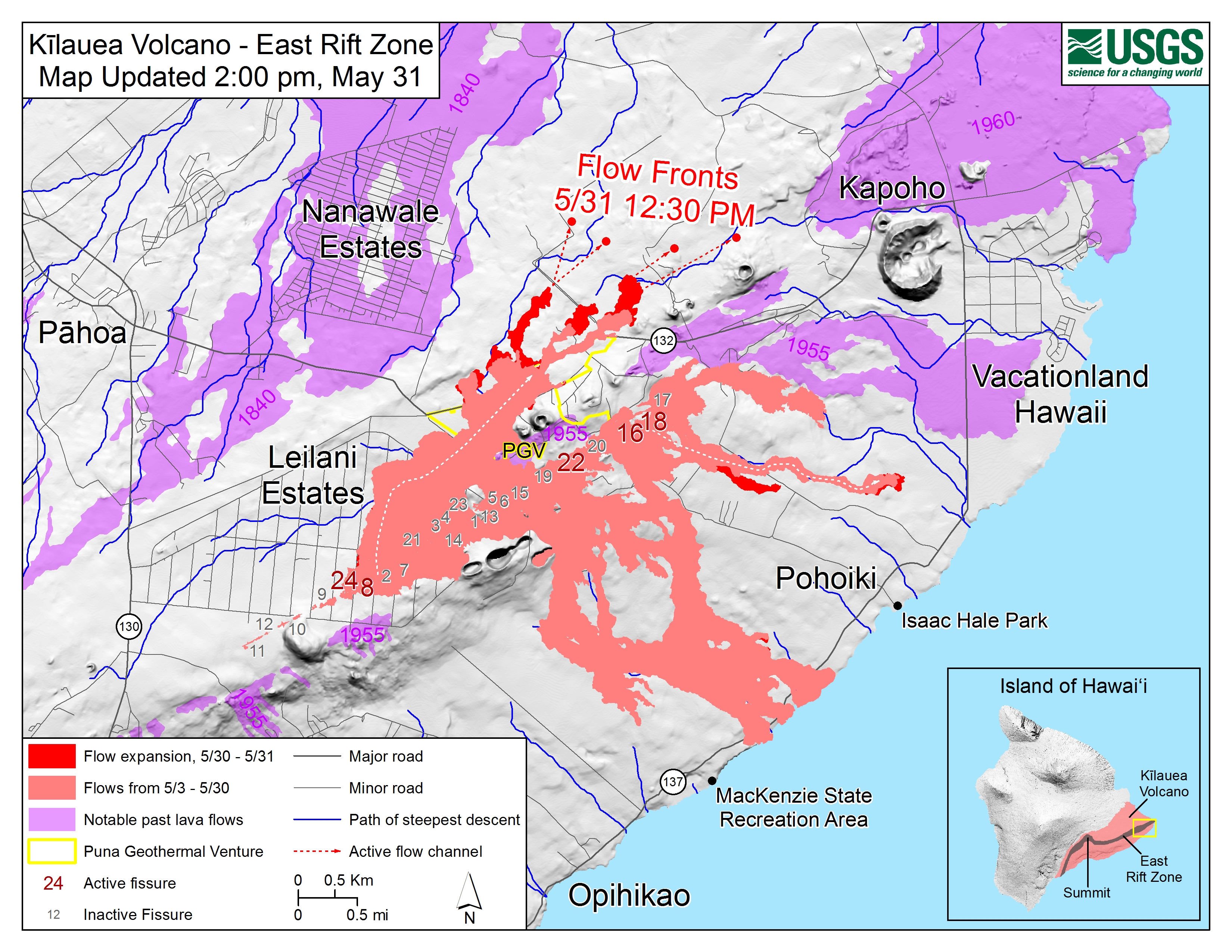
Now that the flow is on the other side of the ridge, how possible is it that it will reach all the way down to Government Beach Road? If it cuts across that road, all of that corner will be unreachable except by helicopter or possibly boat if they could find a spot for a landing. Chain of Craters road is already cut off from that corner of Puna since the flow went down to the ocean on that side.
There's quite a few folks in Kaphoho as well as that whole point of Puna who won't have access if the Gov. Beach road is covered.
"Now that the flow is on the other side of the ridge, how possible is it that it will reach all the way down to Government Beach Road?"
Nobody can say when, but if you look at this map you can see the lava following the blue line (path of steepest decent), and you can see where it goes. The image below will not be automatically updated. To get the most updated map go here- https://volcanoes.usgs.gov/volcanoes...edia_maps.html
So approximately how many people would end up stranded? Hope that doesn’t happen.
Kapoho, Vacationland and the farm lots over in that area are being evacuated. Hopefully, nobody will be left behind and be stranded, but they do have two big helicopters standing by in Hilo in case they do have to go in and get numbers of folks.
I'm not sure how many people would be affected, it's a pretty big area although most of it is really rural. There's quite a few houses in Kapoho, though. I dunno, maybe a thousand people?
Friend of mine lives in the area and starting on Wednesday, he says Gov. Beach Rd was one way. Folks could leave Lower Puna but couldn't go back in afterwards. The next day (Thursday) his area was evacuated. Instead of coming over here (along the Hamakua coast), he is staying in HPP which is much closer to the evacuated house so he can hopefully go back in and get some more stuff tomorrow. Seems a little dangerous to me, 'stuff' is pretty easy to get and not really worth someone being endangered, but some folks are more enamored of 'stuff' than others.
Good Luck and Godspeed to all of you living on The Big Island.
Please register to post and access all features of our very popular forum. It is free and quick. Over $68,000 in prizes has already been given out to active posters on our forum. Additional giveaways are planned.
Detailed information about all U.S. cities, counties, and zip codes on our site: City-data.com.

 Please register to participate in our discussions with 2 million other members - it's free and quick! Some forums can only be seen by registered members. After you create your account, you'll be able to customize options and access all our 15,000 new posts/day with fewer ads.