Please register to participate in our discussions with 2 million other members - it's free and quick! Some forums can only be seen by registered members. After you create your account, you'll be able to customize options and access all our 15,000 new posts/day with fewer ads.
Again density doesn’t matter! if you measure by density that it self would be an inaccurate way to determine a comparative city population. The only thing you can get out of that, is how dense a city is. I put it this way some cities don’t put all there eggs in one basket, some cities are laid out!
If suburbs are commuter towns, and the city is the industrial, commercial, commerce and employment center. The best way to determine a comparative city population is to measures the areas around the high industrial, commercial, commerce and employment core of a metropolitan. If a city has any major CBD’s beyond the city limits, the city developed is not totally annex. If large areas of a city have little industrial, commercial developed the city has over annex.
Your post I think is probably the best measure of how truly urban a city is. Your post takes into account different built environments. I think your post, with say a density of around 1-5k, could tell you how urban a city is. Plus commuting patterns.
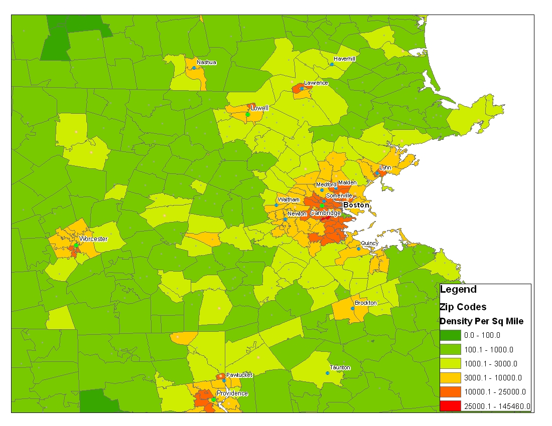
Boston, with over 25k per sq mile as an extra classification:
Boston's density dynamic exceeds that of any other city I've mapped, so far.
It has 35 zip codes with a population density of over 10k per square mile.
The top 3 Pop Density in 2007:
02113 57940 per sq mile
02115 32605.2 per sq mile
02116 23661 per sq mile
Boston's density dynamic exceeds that of any other city I've mapped, so far.
It has 35 zip codes with a population density of over 10k per square mile.
The top 3 Pop Density in 2007:
02113 57940 per sq mile
02115 32605.2 per sq mile
02116 23661 per sq mile
Boston's density dynamic exceeds that of any other city I've mapped, so far.
It has 35 zip codes with a population density of over 10k per square mile.
The top 3 Pop Density in 2007:
02113 57940 per sq mile
02115 32605.2 per sq mile
02116 23661 per sq mile
#35 = Roslindale 02131 at 10476.6 per sq mile
nice! I know you're probably getting a lot of requests, but do you think you could do this for some of the large CA cities?
He did one for LA earlier in thread and would also love to see Miami, NYC, Chicago, Houston and Atlanta but feel bad asking (oh I just did)
I'll get these four out to you, though I already did Houston a few pages ago.
Update: it's going to have to be tomorrow, if that's ok. My ArcMap just chugged out the virtual memory on my machine. Will have to start it up fresh and do it again tomorrow.
I'll get these four out to you, though I already did Houston a few pages ago.
Tried to rep you but wont let me (think i already did) and very much thanks!
Please register to post and access all features of our very popular forum. It is free and quick. Over $68,000 in prizes has already been given out to active posters on our forum. Additional giveaways are planned.
Detailed information about all U.S. cities, counties, and zip codes on our site: City-data.com.

 Please register to participate in our discussions with 2 million other members - it's free and quick! Some forums can only be seen by registered members. After you create your account, you'll be able to customize options and access all our 15,000 new posts/day with fewer ads.