There always seems to be questions about Connecticut’s climate from folks thinking of relocating here or even from residents. Having background in climate science and working with a firm that creates climate and demographic maps …I thought a page showing Connecticut climate data and Connecticut in relation to the rest of the USA would be useful. Perhaps the moderators can make this link appear near the top so folks looking for climate data can see it. If nothing else…at least there will be less misinformation about the true nature of Connecticut’s climate in relation to the rest of the USA.
All of the data is public information supplied by (NOAA) and the National Weather Service.
The two reference stations used were the National Weather Service station Bradley Airport in Windsor Locks (extreme northern CT) and the National Weather Service station in Bridgeport (in extreme southern CT).
The Climate of Connecticut
Connecticut is located in the lower middle latitudes between 41 and 42 latitude along the East Coast of the United States. In terms of climate classification…
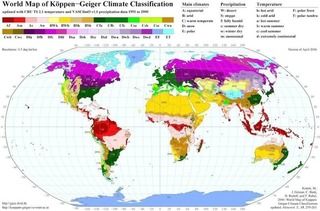
Connecticut is located in the climate type known as “Warm Temperate” Cfa. Here is a basic climate classification map. For reference - much of eastern China, Korea, Japan, and parts of eastern Australia are located in the same type of climate as the eastern United States.
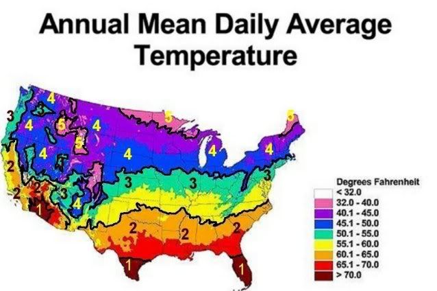
 ANNUAL MEAN DAILY TEMPERATURE
: The average annual mean temperature is the average surface temperature averaged throughout the entire year. Most of Connecticut has an annual mean temperature of about 51 F. Places in the far north (up along the Massachusetts state line) have the coldest mean temperatures (about 49 F)…while places along the I-95 corridor in coastal Connecticut have the warmest mean temperatures (about 52 F).
For international residents here is a quick reference to a few World cities and their annual mean temperatures:
Vermilion, Canada (27 F)
Helsinki, Finland (38 F)
Moscow, Russia (39 F)
Montreal, Canada (41 F)
Berlin, Germany (47 F)
London, England (51 F)
Beijing, China (52 F)
Pusan, S. Korea (54)
Nice, France (57 F )
Naples, Italy (62 F)
Hong Kong, China (73 F)
Kingston, Jamaica (77 F)
Bridgeport, CT (52 F) Windsor Locks, CT (49 F).
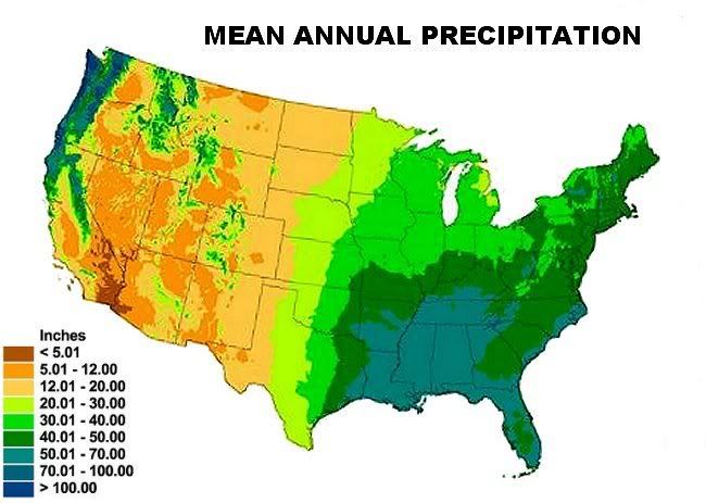
 MEAN ANNUAL PRECIPITATION
: The mean annual precipitation is the average amount of precipitation (rain/melted snow combined) that falls over thorughout the year.
With the exception of the Pacific Northwest…the far Eastern United States east of the Mississippi River (about 90 W) and south of the Northern New England States (about 44 N)… has the highest amount of precipitation on the USA mainland. Regionally, the eastern portion of the USA mainland becomes increasingly hotter and wetter as you move southward. In terms of seasonal rainfall, although most locations south of Boston and east of the Mississippi have slightly more rainfall in the warm season than in the cool season...rainfall is evenly distrubuted throughout the year. The monsoonal tendency of precipitation (dry winters – wet summers) increases rapidly toward the southern subtropical Gulf and South Atlantic States. Typically, rainfall in the eastern USA in the warm/hot months falls a quick convective showers/thunderstorms, which drop a lot of rain in a short time period. So sunshine is markedly greater than in the cool season.
Connecticut receives about 40 to 50 - inches of precipitation each year.
 MONTHLY MEAN TEMPERATURES FOR EXTREAM MONTHS:
 Generally January is the coldest month and July is the hottest month across the United States. The two maps below show the mean temperatures for the extreme months across the USA.
January mean temperatures range from the single numbers (5 to 7 F) across northeastern Wyoming, North Dakota, and Minnesota…to the upper 60’s across south Florida (Ft. Lauderdale 68 F/Key West 70 F). July temperatures are much more uniform across the USA. Most locations have a mean temperature of above 70 F. The subtropical South Atlantic/Gulf states and the deserts of the Southwest are the hottest…while northern New England, areas along the Canadian border, the mountain West, the Pacific NW, and coastal California are the coolest.
Bridgeport, CT - January (30 F)
July (74 F)
Windsor Locks, CT - January (27 F)
July (74 F)
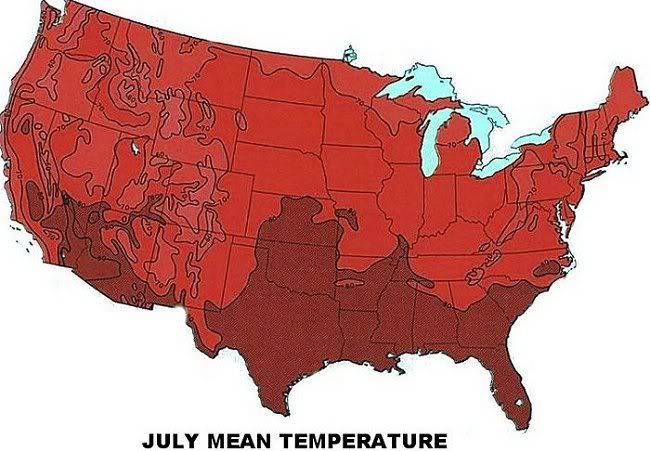
JULY
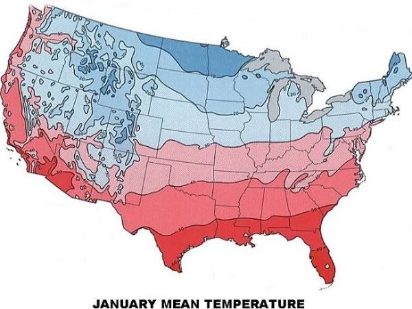
JANUARY
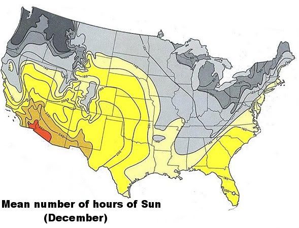
MEAN SUNSHINE IN WINTER: The maps below show the mean number of hours of sun for December… the cloudiest month on average across the United States. Winter sunshine is often a big issue when regions are contemplated. In summer most regions of the USA mainland have ample sunshine.
In December, the cloudiest areas of the USA have less than 140 hours of sunshine (meaning that around half the month may be cloudy)…while some areas have less than 100 hours in December of sunshine. The area around the Great Lakes and the Pacific Northwest are the cloudiest while areas in the Southwest and south Florida have the most sunshine. The USA mean average sunshine in December is (146.6 hours).
Bridgeport, CT averages 154 hours of sunshine in December and Windsor Locks, CT averages 148 hours of sunshine. As a whole…northwest Connecticut is the cloudiest region of the state.
 GARDEN ZONE
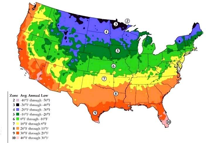
: Anyone who gardens is familiar with the USDA or Abor Day garden zone map. The USA is divided into 10 zones…based on the average annual yearly extreme low. Connecticut falls in the middle zones. Most of Connecticut is in southern Zone 6, while the I-95 corridor in southern Connecticut is in northern zone Zone.

 Please register to participate in our discussions with 2 million other members - it's free and quick! Some forums can only be seen by registered members. After you create your account, you'll be able to customize options and access all our 15,000 new posts/day with fewer ads.