Please register to participate in our discussions with 2 million other members - it's free and quick! Some forums can only be seen by registered members. After you create your account, you'll be able to customize options and access all our 15,000 new posts/day with fewer ads.
The core city of many American metro areas are located on the banks of a major river: New Orleans, Kansas City, Cincinnati, etc. That's because a lot of cities were established as river towns, and then grew by expanding away from each side of the river.
But among such metro areas, there is sometimes a great variance in what proportion of population resides on each side of the river. And sometimes not. Here are a few examples...
Minneapolis-St Paul MSA: The metro area is bisected by the Mississippi, and its population is nearly evenly split on both sides of the river. I have calculated that 52.3% live west of the river, and 47.7% east.
St Louis MSA: Again, the metro area is bisected by the Mississippi, but this time, the Missouri side has the lion's share of the population. I figure that 75.4% live west of the river, and 24.6% east.
Memphis MSA: This area is an example of extreme population imbalance. A whopping 95.7% of the population lives east of the Mississippi, with only 4.3% west.
Any thoughts as to why there is such a variance from metro to metro?
Please feel free to post the proportions for other river-based MSA's.
Memphis MSA: This area is an example of extreme population imbalance. A whopping 95.7% of the population lives east of the Mississippi, with only 4.3% west.
Any thoughts as to why there is such a variance from metro to metro?
Terrain?
Repeated flooding on the Arkansas side of the river would probably account for the discrepancy between Memphis TN and West Memphis AR. Memphis was better situated for growth because of it's more protected location on a bluff.
"The West Memphis area usually flooded in the spring until the St. Francis Levee District was established in 1893. However, private landowners along the Mississippi River built levees that were only three or four feet high. In 1912 and 1913, the St. Francis main levee broke, flooding the area from West Memphis to Forrest City; Hopefield was washed away in 1912. The current was so strong that steel rails wrapped around trees. During the Flood of 1927, another break in the levee left the area under water, and during the Flood of 1937, the river washed over the top of the levees." West Memphis (Crittenden County) - Encyclopedia of Arkansas
Location: Cleveland bound with MPLS in the rear-view
5,509 posts, read 11,870,451 times
Reputation: 2501
Minneapolis/St. Paul lies within its own state, whereas Memphis and St. Louis border other states and squeeze the population to spread more towards its own state. That's my guess.....political boundaries.
In may of the cities the river is a major barrier, resulting in the majority of the population living on one side or the other. In New Orleans there are only two bridges across the Mississippi which is quite a deterrent to development on the west bank. This is also an issue in Memphis and St. Louis, but less so in Minneapolis where the river is much smaller and bridges don't need to be built high enough for river traffic to pass under.
Location: Cleveland bound with MPLS in the rear-view
5,509 posts, read 11,870,451 times
Reputation: 2501
We have river barges in Minneapolis and St. Paul, so high bridges are not the deterrant for us, but the river isn't as wide as in N.O., so that may be parrt of it.
We have river barges in Minneapolis and St. Paul, so high bridges are not the deterrant for us, but the river isn't as wide as in N.O., so that may be parrt of it.
You are correct; I didn't mean to infer that there is no river traffic in Minneapolis, but river barges hardly require the clearance than ocean-going vessels require.
In most cases, which ever side of the river the main city is located, that is where the bulk of the population is going to be. In other cases, the city is located on both sides of the river. When a city is developed like that, then most likely the wealthier side has more people than the poorer side. I use Rockford as an example. Rockford's westside is generally the bad side and it is less populated.
Rockford
pop. 157,000
metro: 350k-400k
By looking at the map, the bulk of the population is on the eastside of the river.
Location: Cleveland bound with MPLS in the rear-view
5,509 posts, read 11,870,451 times
Reputation: 2501
So far I like the river as barrier to growth and the fact that in most cases another state becomes a barrier to growth as the two primary reasons why cities don't always spill over to the other side of a river.
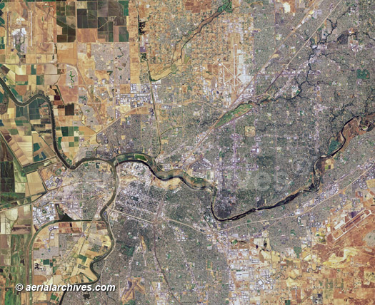
Sacramento's downtown is located at the location where the American River meet the Sacramento River. The 2.1 million population metro area grew overwhelmingly east into the foothills up towards Folsom Dam/Lake whereas western growth was limited. The land to the west of downtown Sacramento is some of the most prime farm land in California and excellent for growing rice in particular.
Please register to post and access all features of our very popular forum. It is free and quick. Over $68,000 in prizes has already been given out to active posters on our forum. Additional giveaways are planned.
Detailed information about all U.S. cities, counties, and zip codes on our site: City-data.com.

 Please register to participate in our discussions with 2 million other members - it's free and quick! Some forums can only be seen by registered members. After you create your account, you'll be able to customize options and access all our 15,000 new posts/day with fewer ads.