Please register to participate in our discussions with 2 million other members - it's free and quick! Some forums can only be seen by registered members. After you create your account, you'll be able to customize options and access all our 15,000 new posts/day with fewer ads.
Give us a map or a a detailed description of the the geography of your state/city/region- you can present any other areas you find interesting as well.
i find it interesting how the geography of cities affect the population density/structures, and the transportation infrastructure. nyc area is a prime example of how the population has settled along water, and where the land was available, as opposed to a land-locked city, where population trends generally seem to grow evenly in all directions (relatively).
In NY, the island of manhattan seemed to fill up from the bottom up first. Then, when the brooklyn bridge was built, brooklyn started to become populated. As more bridges connected manhattan to long island, the population moved eastward. The LIRR is a very busy commuter train line that allows people to live way out east on the island, and commute to the city:
Looking north, the population trends seemed to uniformly move up into the bronx and then to westchester, where it naturally tapers off as you get north of the I-287 corridor. However, on that same latitude across the Hudson (Rockland County), that area was farmland until the mid 20th century, beacuse no bridges gave access to it directly, unless one were to go way up to the Bear Mountain bridge, or cross the GW bridge into jersey and move north. With the introduction of the Tappan Zee Bridge, Rockland then began to fill up.
stuff like that is interesting with respect to geography.
I don't know anything about cities like Denver or Salt Lake City, but i bet they follow the valleys of the mountain ranges in a similar fashion
Did this thread die for lack of interest ? Hardly the case with so few posts. You can take any map, Sat or otherwise and build a history, a story , if told right would captivate the audience . As in science Neal dresse Tyson has been able to find this niche and it's working !
Did this thread die for lack of interest ? Hardly the case with so few posts. You can take any map, Sat or otherwise and build a history, a story , if told right would captivate the audience . As in science Neal dresse Tyson has been able to find this niche and it's working !
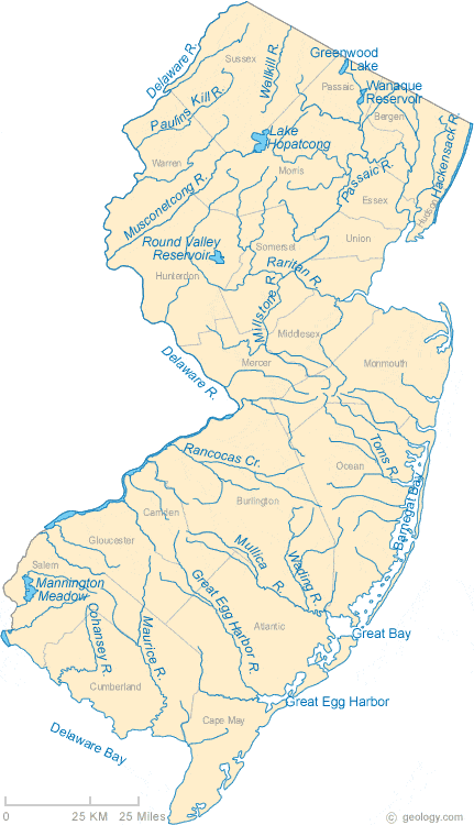
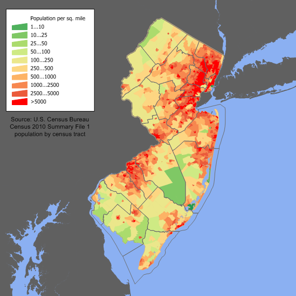
Ok I am game. If you look at the maps of New Jersey (post 3), you can see how the hilly areas of northwest New Jersey helped hold back the urban tide.
Ok I am game. If you look at the maps of New Jersey (post 3), you can see how the hilly areas of northwest New Jersey helped hold back the urban tide.
That area of NJ. Is quite hilly , the culture goes along with it. I had a friend who lived up there for many years. He had a successful business going in warehousing . The only time he went to The populated areas was reluctantly . His interest, family had more ties to Conn.,Mass,.And always vacationed on Cape Cod..
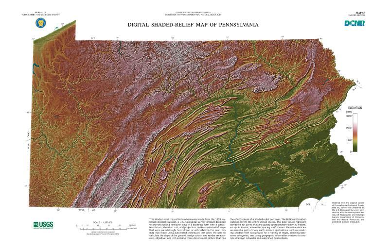
There's a reason why the Geology department at the University of Georgia has a map of the geological provinces of Pennsylvania on the wall in one of its classrooms: because it's actually pretty remarkable. Not only is it remarkable how not flat Pennsylvania is overall, but the topography actually looks unusual too, with a bunch of weird-looking and seemingly endless ridges in the middle. There are only a few places where highways, railroads and other critical cross-state infrastructure can go.
If you overlay the two maps on each other, you can figure out why nobody lives in northern Pennsylvania. You can also figure out that the population density in the Pittsburgh metropolitan area is skewed lower by its six outlying counties, which become somewhat thinly populated the farther away from Allegheny County you go.
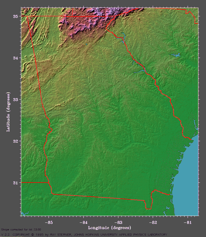
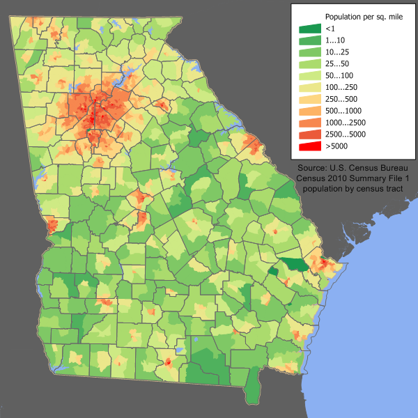
Not as pretty as Pennsylvania's topographic map, but it shows that the terrain is actually very diverse, with everything from coastal plains to mountains that are almost a mile above sea level. Those mountains are like atmospheric wringers, taking all the humid Southern air and wringing it out whenever there's a southerly wind flow. Much of that precipitation falls as snow in the winter too.
If you look at the maximum population densities in the Atlanta metropolitan area versus the Philadelphia and Pittsburgh metropolitan areas, you can see that the two Pennsylvania cities have larger areas of maximum density, though Atlanta seems to have a larger area of medium-high densities in outlying metropolitan counties.
I had a geography professor (from California) who made fun of Pennsylvania's mountains, "More like bumps!"
They may not be high, but if a geography professor, of all people, can't recognize the sheer unusual and varied nature of Pennsylvania's topography, I couldn't respect him. I dropped the class.
My guess your Geo Prof was not what the title suggest . Geography has been so short changed over the years that it gets no respect. There are plenty of hack academics that pose as a " geography professor " along with other varied informant endeavors, teaching our brightest students the wrong side of " fill in " subjects/ classes. I would have dropped that class too.
Now , there are several types of elevations. 3,000 feet in Pa. Could be equal to 7,000 ft. In the West depending on weather, definition , sea level, oceans, and age.
Please register to post and access all features of our very popular forum. It is free and quick. Over $68,000 in prizes has already been given out to active posters on our forum. Additional giveaways are planned.
Detailed information about all U.S. cities, counties, and zip codes on our site: City-data.com.

 Please register to participate in our discussions with 2 million other members - it's free and quick! Some forums can only be seen by registered members. After you create your account, you'll be able to customize options and access all our 15,000 new posts/day with fewer ads.