Please register to participate in our discussions with 2 million other members - it's free and quick! Some forums can only be seen by registered members. After you create your account, you'll be able to customize options and access all our 15,000 new posts/day with fewer ads.
Just sharing some images of sections/excerpts from old maps of various US cities that I've collected. These maps are all, at this point, out of copyright at this point: if the company went out of business, or if the map was otherwise not updated after 1964, it's public domain now.
It's interesting to see how cities have changed over the years. Each of these images are also interesting in another way - how hand-drawn or engineering-standard drafting first went the way of CAD systems, and now GPS. Pre-1960 or 70, most maps were sold in cardstock protective sleeves, and the map would fold out of the sleeve.
1. Anchorage, Alaska, 1957 (Map by MAPCO)
2. Biloxi, Mississippi, 1940s (Map by Dolph)
3. Boston, Massachusetts, ~1945 (Map by Geographia)
4. Charlotte, North Carolina, 1948 (map by Dansbury-Hill)
5. Fort Lauderdale, Florida, ~1950 (Map by Dolph)
6. Miami, Florida, 1945 (Map by Karl Squires Engineers)
7. Milwaukee, Wisconsin, 1937 (Map by The A. C. Wagner Company)
8. Oakland, California, 1939 (Map by Rand McNally)
9. Pittsburgh, Pennsylvania, 1957 (Map by MAPCO)
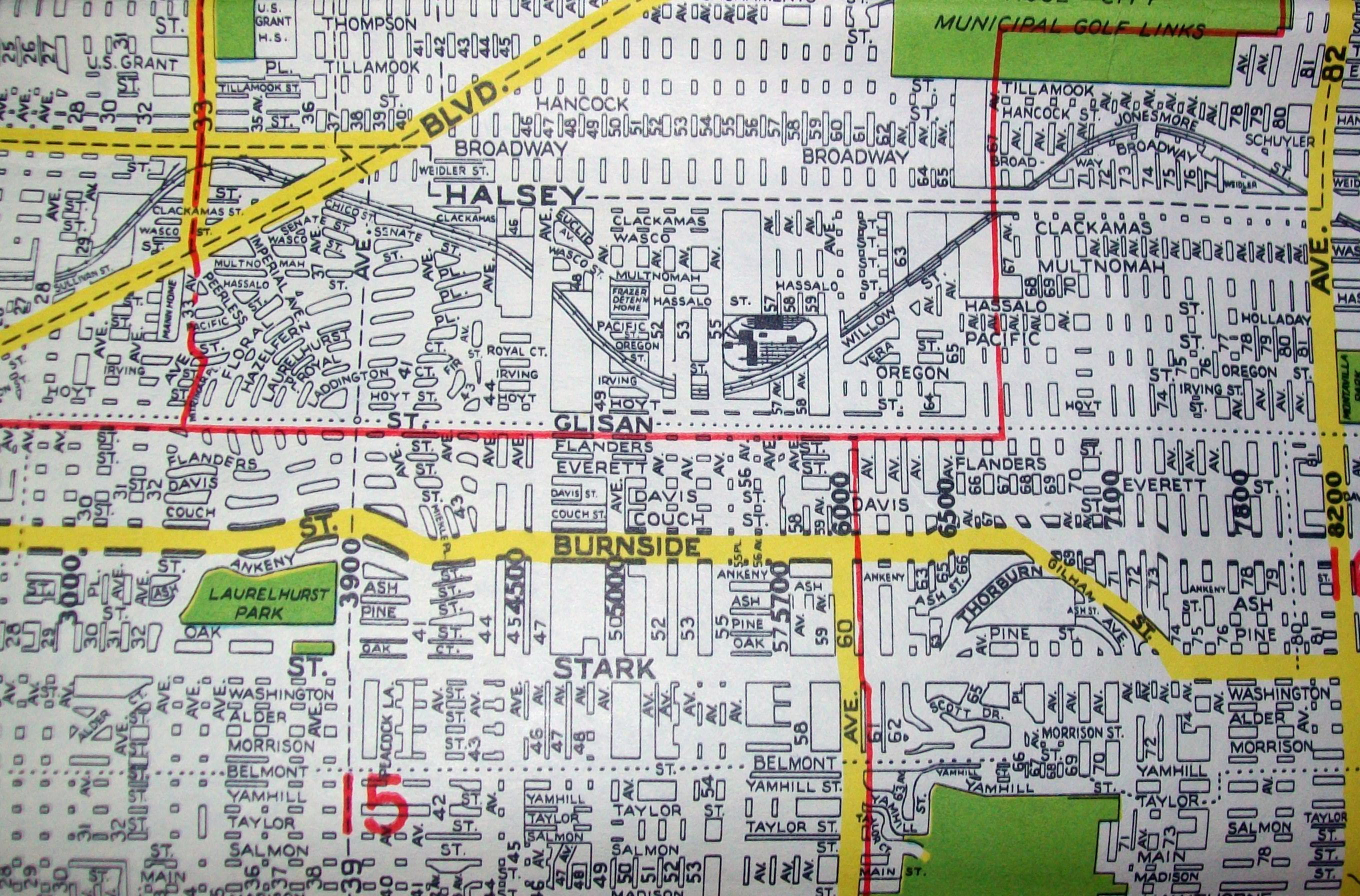
10. Portland, Oregon, 1948 (Map by Geographia)
11. Rochester, New York, 1930 (Map by Sampson & Murdock)
12. San Francisco, California, 1931 (pre Golden Gate and Bay Bridges)(Map by Bekins Moving & Storgae)
13. San Francisco, California, 1945 (Map by Thomas Brothers)
14. San Francisco, California, 1945 (Map by Rand McNally)
15. San Jose, California, 1943 (Map by Thomas Brothers)
16. Seattle, Washington, late 1940s (Map by Kroll)
17. Saint Petersburg, Florida, 1955 (Map by Dolph)
18. New Orleans, Louisiana, 1958 (Map by MAPCO)
19. Oakland, California, 1943 (Map by Thomas Brothers)
St Louis (1950s), Kansas City (1950), Phoenix (1957), Albany NY (1939), Cleveland (1960), Boston downtown (1940s), Schenectady (1954), Tallahassee (1960)
These are great! I love looking at old maps of cities before the interstates decimated them! Are they your private collection or are they accessible in line?
This might be of interest in this thread. The maps are Shell atlases from 1956. A lot of the freeways are either under contrustion or still in the planning stages for most cities. Maps are also zoomable. (listed in no particular order, pretty much posted what I found)
PS: After looking through these maps, freeways were a great idea for connecting cities over great distances, but definitely ruined and destroyed the fabric of their cores.
This is just a collection I've built up over the years - I started collecting when I was middle-school age, and I'm 43 now.
Several things strike me from looking at them:
* Street car and trolley lines in cities into the 1950s (they are typically red solid or dashed lines on otherwise b&w maps)
* Suburban growth really was at warp speed in the 1960s and 70s. I have maps of Detroit, Atlanta, Washington, San Diego, Denver, Cleveland, Miami, Charlotte, San Antonio, Fort Worth, Austin - to name just a diverse few, and the ONE thing that they had in common (NOT anymore) was a fairly dense core city, with rural - not suburban - territory starting not far beyond the city limits of the day. Price Georges and Montgomery Counties in Maryland, for example, were still predominantly rural, or small-ish towns that had distinct separations between them. The Megalopolis was something of an exception to this, at least from around Wilmington DE on up to Boston, but even it hadn't filled in to nearly the degree visible today. It has been within - say - a couple generations - that the sprawlopolis was invented, a blip historically speaking, which nonetheless has still wasted SO SO much land.
* There WERE Freeway Revolts (I think this has been a topic on C-D before) - for all the freeways that DID get built, dozens were cancelled. There were proposed 3-digit-interstates in Boston, Washington, Brooklyn, Queens, Manhattan, Bronx, Staten Island, Elizabeth NJ, Philadelphia, Somerset County NJ, Albany, Baltimore, Columbia (SC), Atlanta, St Petersburg (FL), Memphis, Detroit, Chicago, Milwaukee, San Francisco, Los Angeles, New Orleans, St Louis, Minneapolis, Portland (OR), Cleveland - along with some mainline segments of interstates that had to be draastically re-routed in all of those cities. Brutal to think - in retrospect - that - as cut up by freeways some of those cities are today, the original "vision" was worse.
I've really enjoyed this thread. It's endlessly fascinating to see how cities have grown and changed, in ways both great and awful.
I have a flickr page with many, many map pics, along with other things like gardening, nature, and family. There's a folder to the side on the first page called "Maps And Legends" (named after an old R.E.M. song about touring and traveling when they were young and poor). That folder has nearly 300 snaps of various cities - mostly street maps, a few road maps or geographical maps mixed in. You are welcome to check it out:
Thanks for the link to your page, davidals. Just spend ~30 minutes perusing your collection. I'll have to go back again and look some more. It's quite impressive!
Wow - I didn't realize until now, that there were SO MANY of the so-called "temporary" Federal office buildings stretching along the entire West end of Washington DC's National Mall (green park). My mother worked in one of them during the 1940s. Glad that the last of these eyesores were torn down about 1970. Now the Park Service needs to finish its restoration of the memorial reflecting pool area, which is presently all torn-up.
And think of how rich one could be, if they had bought up the rural land around suburban Tyson's Corner (where 100,000 people now work). Who would have guessed, back then?
Last edited by JMT; 08-12-2012 at 08:09 PM..
Reason: Please review the General U.S. forum sticky for rules for posting images.
Please register to post and access all features of our very popular forum. It is free and quick. Over $68,000 in prizes has already been given out to active posters on our forum. Additional giveaways are planned.
Detailed information about all U.S. cities, counties, and zip codes on our site: City-data.com.

 Please register to participate in our discussions with 2 million other members - it's free and quick! Some forums can only be seen by registered members. After you create your account, you'll be able to customize options and access all our 15,000 new posts/day with fewer ads.