Please register to participate in our discussions with 2 million other members - it's free and quick! Some forums can only be seen by registered members. After you create your account, you'll be able to customize options and access all our 15,000 new posts/day with fewer ads.
Andersonville was run by some Austrian. Not a Confederate. The Confederacy could barely feed their own army, let alone the Yankees.
In fact, thats why the prisoners were starving. They simply had no food for them.
Im not saying the South is perfect, but the North wrote history as if they were all about freeing slaves, and that was a flat out lie.
The North didn't care about slaves. They just wanted to preserve the Union.
I look at it from both perspectives. Each side was flawed in a certain way, each side wanted its way of life preserved, and the north was not interested in seeing a country become divided over this issue while the south was. THat I think is what the war was really about. For the South, it was about state's right and slavery. For the North, it was about both their way of life but to a much greater degree was about preservation of the Union. They did not want the country to become half of what it was because of slavery. In my eyes they didn't look at it so much as an inhuman practice as one that was threatening to divide the country. in any case, even though the Civil War was won, blacks were still discriminated against for years and years afterwards for the next 100 years. So really, it was a long time before blacks were given true equality. And both sides are to blame for that. In the end, the whole point of it is we are still a united country today and ultimately bettered ourselves. North, South, East, and West, we are all one and the same. I'm grateful to be born and raised in the United States. Each day I wake up and realize what life must be like in countries like Rwanda and Sudan and Central America, then realize just how lucky I was to be born in this country. I have been to several countries now...the whole United Kingdom, France, Canada, and Mexico, and while all these places are great countries, the country with the red stripes and white stars will always be my favorite country. Our food, our economic system, our diversity, and our culture, and most importantly, our spirit, cannot be matched by any other country in the world. In fact, lol, is it just me or do mexican and Chinese food taste better here? hehe.
I am deeply in love with New England and never get bored of its beauty, charming villages, from the stunning coast of Maine to the White Mountains of NH , Vermont, Massachusetts ,Rhode Island, Connecticut, it 's all a delight for me.
In the autumn in particular when the air is crisp and the nights grow longer, and the leaves are turning, it is so, so beautiful.
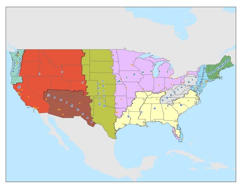
My perception of the U.S. is a little different in that I think an entire state, per se, should not be lumped into an entire categorization. Moreover, I think the person who polled would probably better have served the voters by reclassifying the "northeast" as New England, while keeping the Mid Atlantic as is. That said, I decided to make a map of the entire nation, with some additional regions. I think Appalachia is distinct enough to have its own region, as well as the Great Plains, which I think can be distinguished from the Midwest in that its land usage is more bent towards range and cattle, and is more arid, where as the Midwest is more breadbasket. I could have subcategorized further: for instance, the Upper Midwest could have served Minnesota, upper Michigan and parts of Wisconsin better. When I drew borders here, 3 states stood out as overly problematic: Texas, New York, and Florida. New York was the toughest: I think there are 4 distinct regions in New York, it has the tail end of New England, definitely Mid Atlantic, the southern Tier is Appalachia, and if you've ever been there, the Buffalo-Rochester area to me is more Midwest than anything. The upper part of New York, in the Adirondacks, is where I had trouble making borders. Florida, for obvious reasons, is a real ball buster: the panhandle is easy, definitely south. The interior, I made south as well, and would have been definitely south as recently as 25 years ago, however, people are relocating further inland to beat high real estate costs. The gold coast I made midwest, (due to the I-75 southbound migration from midwest cities) which is the only 'exclave' along with the southeast part of Florida, clearly more disposed to 'mid-Atlantic' than any other region. Texas was also very difficult, especially south Texas, which is almost more subtropical than anything else. South Texas almost should go back to Mexico, I felt when I was making borders it is more in common with Mexico than any other region of the U.S. but I very conveniently put it into Great Plains.
Anyway, here is my stab at it, 9 regions in total:
1) New England
2) Mid Atlantic
3) South
4) Appalachia
5) Midwest
6) Great Plains
7) Southwest
8) West
9) Pacific Northwest
Anyway, here is my stab at it, 9 regions in total:
1) New England
2) Mid Atlantic
3) South
4) Appalachia
5) Midwest
6) Great Plains
7) Southwest
8) West
9) Pacific Northwest
Mike, there are so many variations of what is considered a "region" I came up with the list when I Googled US Regions. I still feel the USA is one region together.
My perception of the U.S. is a little different in that I think an entire state, per se, should not be lumped into an entire categorization. Moreover, I think the person who polled would probably better have served the voters by reclassifying the "northeast" as New England, while keeping the Mid Atlantic as is. That said, I decided to make a map of the entire nation, with some additional regions. I think Appalachia is distinct enough to have its own region, as well as the Great Plains, which I think can be distinguished from the Midwest in that its land usage is more bent towards range and cattle, and is more arid, where as the Midwest is more breadbasket. I could have subcategorized further: for instance, the Upper Midwest could have served Minnesota, upper Michigan and parts of Wisconsin better. When I drew borders here, 3 states stood out as overly problematic: Texas, New York, and Florida. New York was the toughest: I think there are 4 distinct regions in New York, it has the tail end of New England, definitely Mid Atlantic, the southern Tier is Appalachia, and if you've ever been there, the Buffalo-Rochester area to me is more Midwest than anything. The upper part of New York, in the Adirondacks, is where I had trouble making borders. Florida, for obvious reasons, is a real ball buster: the panhandle is easy, definitely south. The interior, I made south as well, and would have been definitely south as recently as 25 years ago, however, people are relocating further inland to beat high real estate costs. The gold coast I made midwest, (due to the I-75 southbound migration from midwest cities) which is the only 'exclave' along with the southeast part of Florida, clearly more disposed to 'mid-Atlantic' than any other region. Texas was also very difficult, especially south Texas, which is almost more subtropical than anything else. South Texas almost should go back to Mexico, I felt when I was making borders it is more in common with Mexico than any other region of the U.S. but I very conveniently put it into Great Plains.
Anyway, here is my stab at it, 9 regions in total:
1) New England
2) Mid Atlantic
3) South
4) Appalachia
5) Midwest
6) Great Plains
7) Southwest
8) West
9) Pacific Northwest
I disagree with some of the boundaries of this map. First off, the South does not extend anywhere near as far north in Missouri or Illinois as this map says. I know this region probably better than anybody on here...trust me, the South does not really begin until around Cape Girardeau, really far south in Missouri and the very bottom of Illinois. This makes sense because it's where the Mason-Dixon line is. Also, Oklahoma and Texas are not part of the Midwest. That much I can conclusively say without a doubt. I could understand Oklahoma being called Midwestern, it does have some clear Midwestern characteristics but it also has many Southern and Southwestern characteristics. but there is nothing midwestern about Texas. The South covers a much broader region of Texas. And Upstate New York is not the Mid-Atlantic. Arkansas is not Midwestern whatsoever except maybe in its Northwestern-most corner. Other than that, I pretty much agree with this map. I agree with the rest of the map generally, although I don't think that Appalachia extends as far into Ohio as the map says. Also, Missouri when Kansas, Nebraska, and Illinois are not on its eastern and western borders, is more Southern than Midwestern. South of Joplin and Springfield and highway 60 in general, Missouri has a true Southern culture. this is overall a very small percentage of the state though, less than 10% roughly. the bootheel is unquestionably Southern.
I was going to vote Northeast, but then I read your definition, which is actually what most people would call New England. So using your definitions, I'd vote for "Mid-Atlantic" and "Northeast" together.
I voted wrong because I too was opting for the Mid-Atlantic by definition
I disagree with some of the boundaries of this map. First off, the South does not extend anywhere near as far north in Missouri or Illinois as this map says. I know this region probably better than anybody on here...trust me, the South does not really begin until around Cape Girardeau, really far south in Missouri and the very bottom of Illinois. This makes sense because it's where the Mason-Dixon line is. Also, Oklahoma and Texas are not part of the Midwest. That much I can conclusively say without a doubt. I could understand Oklahoma being called Midwestern, it does have some clear Midwestern characteristics but it also has many Southern and Southwestern characteristics. but there is nothing midwestern about Texas. The South covers a much broader region of Texas. And Upstate New York is not the Mid-Atlantic. Arkansas is not Midwestern whatsoever except maybe in its Northwestern-most corner. Other than that, I pretty much agree with this map. I agree with the rest of the map generally, although I don't think that Appalachia extends as far into Ohio as the map says. Also, Missouri when Kansas, Nebraska, and Illinois are not on its eastern and western borders, is more Southern than Midwestern. South of Joplin and Springfield and highway 60 in general, Missouri has a true Southern culture. this is overall a very small percentage of the state though, less than 10% roughly. the bootheel is unquestionably Southern.
I also believe that the South should go farther up and into Southern Indiana even. I have heard it said that people in Indy think that Corydon, IN and points south should secede and become part of KY!
Please register to post and access all features of our very popular forum. It is free and quick. Over $68,000 in prizes has already been given out to active posters on our forum. Additional giveaways are planned.
Detailed information about all U.S. cities, counties, and zip codes on our site: City-data.com.

 Please register to participate in our discussions with 2 million other members - it's free and quick! Some forums can only be seen by registered members. After you create your account, you'll be able to customize options and access all our 15,000 new posts/day with fewer ads.