Please register to participate in our discussions with 2 million other members - it's free and quick! Some forums can only be seen by registered members. After you create your account, you'll be able to customize options and access all our 15,000 new posts/day with fewer ads.
haha. I think in one of those threads I posted links to at least 10 other threads related to city skylines.
I think the next project is to find out how many threads begin with:
"Hi. I'm in my 20s and hate where I live. Help me find a town that meets these criteria: Lots of young people, hip, educated, lots of jobs, but undiscovered, cheap housing, cheap healthcare, at least 3 trader joes stores within walking distance, lots of sunshine and no rain but not a desert, four seasons but no cold weather, and apartment managers that allow you to have a cheetah."
"Hi. I'm in my 20s and hate where I live. Help me find a town that meets these criteria: Lots of young people, hip, educated, lots of jobs, but undiscovered, cheap housing, cheap healthcare, at least 3 trader joes stores within walking distance, lots of sunshine and no rain but not a desert, four seasons but no cold weather, and apartment managers that allow you to have a cheetah."
Although Kentucky is considered to be a southern state, and it is, you can't say that it is without saying that parts of Illinois, Indiana, Ohio, and Missouri aren't. The time I drove through Missouri into Illinois,if I hadn't known any better I could have gotten away with thinking that I was in some desolate part of the South. Accents and all!
It's true. Missouri, Illinois, Indiana, and Ohio all have major Southern components to them. I like to think of them as midwestern states with Little Dixies in their southern parts. THe historic Little Dixie region in Central and North Central Missouri is now very much a part of the Midwest, so that no longer really counts as a "Little Dixie."
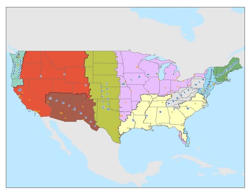
I made a map for another thread I thought I'd share for this board. I made the South a region, as I did Appalachia, because I think the mining extraction element as primary economy belongs in Appalachia. That's how I distinguished it from the South, which is more agricultural. I also put in all the other regions. To me, you can't just give an entire state and classify it as a region. For instance, New York to me, is four different regions (little New England, lot of Mid Atlantic, Appalachia on the Southern Tier, and a little Midwest flavor around Buffalo and Rochester).
Anyway, here is my map, and my perception of the South, as well as other regions:
Interesting! I don't agree with it, (especially the Great Plains and Midwestern extension into to Texas, which is to say they dont! LOL Although I do the SW part).
BUT...as you said, it is YOUR perception, which is the point and what counts. Anyway, I would (and bet a few others would too) be interested in making their own maps along these lines. Can you tell us what software or whatever you used to do it? Thanks in advance!
I made a map for another thread I thought I'd share for this board. I made the South a region, as I did Appalachia, because I think the mining extraction element as primary economy belongs in Appalachia. That's how I distinguished it from the South, which is more agricultural. I also put in all the other regions. To me, you can't just give an entire state and classify it as a region. For instance, New York to me, is four different regions (little New England, lot of Mid Atlantic, Appalachia on the Southern Tier, and a little Midwest flavor around Buffalo and Rochester).
Anyway, here is my map, and my perception of the South, as well as other regions:
I find this to be a pretty accurate map, and you definitely nailed Missouri. Here in St. Louis, we always say that south of us is "the South", and north of us is the Midwest. We're just about on the dividing line.
I'm say the Mason-Dixon LIne and everything south of it except for the part of Florida from Orlando southward. Also, culturally Montgomery County, MD and Northern Virginia, the suburbs of DC are not southern. I'm not sure about DC and Baltimore but Western, Eastern, and Southern Maryland are definitely southern. Some people also say that the Triangle in NC is not southern anymore and Atlanta too but I won't go that far.
Florida like I said is southern north of Orlando.
I consider East Texas southern but not the rest of the state. West Texas is very Southwestern with the desert landscapes and cowboys. Dallas-Fort Worth is also southwestern. South Texas is practically part of Mexico. Oklahoma is more Midwestern than southern.
I don't know where to place West Virginia.....its Appalachian, like parts of Maryland and Pennsylvania and western Virginia.
OR.....the south begins wherever the suburban sprawl ends in Northern Virginia. I think 20 years ago it was Springfield but now its Fredericksburg.
For some reason, Richmond is part of Amtrak's "Northeast corridor."
The most common definitions I've heard from friends are
1. the Mason-Dixon Line is still the boundary
2. the Potomac River is now the new border
3. The South starts where people start listening to country music. Nobody I know from north of the Mason-Dixon Line even listens to crossovers like Kenny Chesney or Tim McGraw. Only 2 major stars in Nashville are from the North, and one of them moved south halfway through her life
4. where Wal-Marts is a bigger deal than Starbucks
5. where you start seeing Sonic, Waffle House, Bojangles and Chick fil-A
Interesting! I don't agree with it, (especially the Great Plains and Midwestern extension into to Texas, which is to say they dont! LOL Although I do the SW part).
BUT...as you said, it is YOUR perception, which is the point and what counts. Anyway, I would (and bet a few others would too) be interested in making their own maps along these lines. Can you tell us what software or whatever you used to do it? Thanks in advance!
It's a pretty expensive application, and you need data sets to run it effectively. For instance, I used a county dataset: the boundaries you see here are delineated along county lines.
Last edited by Yac; 12-16-2020 at 01:24 AM..
Please register to post and access all features of our very popular forum. It is free and quick. Over $68,000 in prizes has already been given out to active posters on our forum. Additional giveaways are planned.
Detailed information about all U.S. cities, counties, and zip codes on our site: City-data.com.

 Please register to participate in our discussions with 2 million other members - it's free and quick! Some forums can only be seen by registered members. After you create your account, you'll be able to customize options and access all our 15,000 new posts/day with fewer ads.