Please register to participate in our discussions with 2 million other members - it's free and quick! Some forums can only be seen by registered members. After you create your account, you'll be able to customize options and access all our 15,000 new posts/day with fewer ads.
Vermont has Burlington, Brattleboro, Newphane etc, but where I lived, RUTland, and a lot of other areas in VT, could almost be considered southern 'redneck' if one might be prone to derogatory cliches. There are pockets of liberalism everywhere, but I find most rural areas to be largely 1960's style, conservative.
The OP's observations are likely based on voting results from the past few presidential elections. I would suggest that other posters in this thread base their discussions on empirical, rather than anecdotal, evidence.
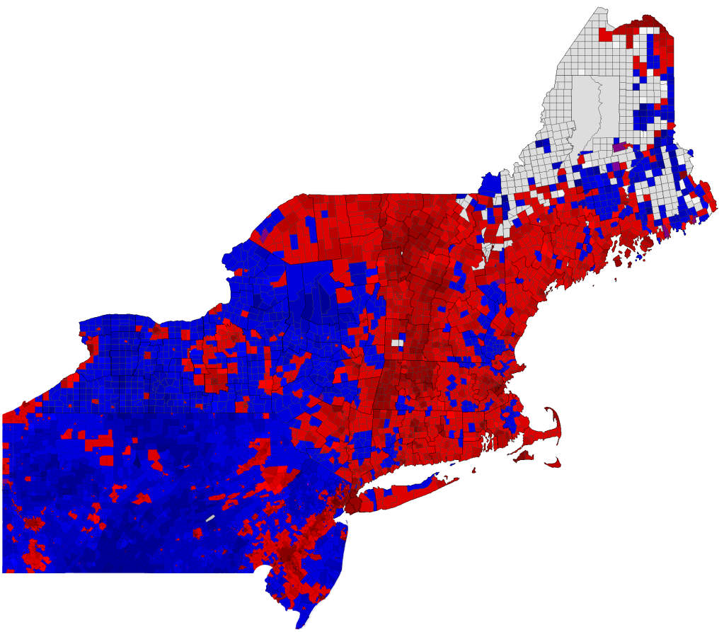
Here is a map of the 2008 election results in the Northeast, shaded by town. Note that this map was created for Dave Leip's Presidential Atlas website, which uses an inverted color scheme: BLUE for McCain and RED for Obama.
As per the OP's observations, the New England states lack the large swaths of NY, PA, and NJ that voted primarily for McCain.
Quote:
Originally Posted by Heyooooo
New England is also nowhere near as liberal as Norcal.
Its also extremely religious, which is hilarious when I see other Northeasterners talking about the Midwest in the same light.
This is inaccurate. New England is extremely religious? Think again: the four states with the lowest church attendance rates in the U.S. are all in New England. All six New England states fall within the bottom 11.
I will take time later to address the OP's question in more detail, but in the meantime I just wanted to talk about the aforementioned differences between VT and NH. These differences are nothing new - I have discussed the history behind this phenomenon here.
Quote:
Originally Posted by cacto
I don't know much about living in the area, though while spending 2 weeks in and around Conway, NH found 4 country stations on the radio and saw many atv's parked in front of the Wal-mart with many shoppers walking around the store in full hunter's camo. Hunting and fishing seemed huge around there and MA was called "Taxachussetts" often. It seemed like there was a rural conservative thing going on there that wasn't known to me before visiting.
I just wanted to point out that aside from the attitude towards "Taxachusetts," most of the things you observed are more characteristic of rural America than they necessarily are of conservatism. Even in the bluest areas of Vermont, you'll hear country stations, see ATVs and plenty of hunters and fishermen. Heck, the same is true of Quebec, just across the border, which is possibly the most liberal region of North America.
Unfortunately I haven't been able to find a town-by-town map of the 2012 results yet. But you're right about the population of NY being heavily concentrated in areas that voted for Obama; those large swaths of towns carried by McCain are mostly sparsely populated. But I think this speaks to the OP's original question, which is why this urban-rural divide doesn't really apply to the New England states. If you look at New Hampshire, for example, most of the towns carried by McCain are the large suburban towns near the Massachusetts border, whereas more rural areas (such as the Connecticut River Valley or the White Mountains) were primarily carried by Obama.
Edit: Although it's not a perfect correlation, I think the map below shows one of the most crucial factors in explaining these voting patterns. Compare this to the map above.
The OP's observations are likely based on voting results from the past few presidential elections. I would suggest that other posters in this thread base their discussions on empirical, rather than anecdotal, evidence.
Here is a map of the 2008 election results in the Northeast, shaded by town. Note that this map was created for Dave Leip's Presidential Atlas website, which uses an inverted color scheme: BLUE for McCain and RED for Obama.
...
I live in one of those grey towns on your map.
The topic of this thread is about rural / urban.
For the Maine portion of your map the grey towns are the rural townships.
Unfortunately I haven't been able to find a town-by-town map of the 2012 results yet. But you're right about the population of NY being heavily concentrated in areas that voted for Obama; those large swaths of towns carried by McCain are mostly sparsely populated. But I think this speaks to the OP's original question, which is why this urban-rural divide doesn't really apply to the New England states. If you look at New Hampshire, for example, most of the towns carried by McCain are the large suburban towns near the Massachusetts border, whereas more rural areas (such as the Connecticut River Valley or the White Mountains) were primarily carried by Obama.
Edit: Although it's not a perfect correlation, I think the map below shows one of the most crucial factors in explaining these voting patterns. Compare this to the map above.
Not exactly. Look at New Hampshire and Vermont - they are definitely not as densely populated as the urban centers along the East Coast, and yet they have similar levels of educational attainment. (Similarly, notice how the very sparsely populated Great Plains have relatively high attainment levels for such rural areas; and pockets of highly educated populations are scattered across the west in otherwise sparsely populated areas - Yellowstone and other places throughout the Rockies jump out most immediately).
It may be difficult to distinguish the shading for the 0-10% range from the white for 'uninhabited,' but I can assure you that this is a very precise map based on Census tracks.
The map doesn't say they're all uninhabited - the data is just missing. It may have to do with how the townships report their election results.
Please register to post and access all features of our very popular forum. It is free and quick. Over $68,000 in prizes has already been given out to active posters on our forum. Additional giveaways are planned.
Detailed information about all U.S. cities, counties, and zip codes on our site: City-data.com.

 Please register to participate in our discussions with 2 million other members - it's free and quick! Some forums can only be seen by registered members. After you create your account, you'll be able to customize options and access all our 15,000 new posts/day with fewer ads.