Please register to participate in our discussions with 2 million other members - it's free and quick! Some forums can only be seen by registered members. After you create your account, you'll be able to customize options and access all our 15,000 new posts/day with fewer ads.
NYC-metro seems to dominate New Jersey, possibly New York too, which might make New Jersey the only state dominated by a metropolitan area not located in it. (Kansas and Kansas-City, Missouri might be close)
Actually NJ is balanced in that it is domonated by two seperate metros NY to north and Philly to the south; both cities outside the state but directly on it its's borders seperated by either the Hudson or Delaware rivers
btw cool map in the earlier post by Billiam - reps to you
I am thinking that another factor is even if there is more than one city, it could still be unbalanced if they are very similar in nature. Also some states could have their rural areas count as a significant pole of balance, especially if there is a mid-sized and/or growing area that is similar in nature. Also in unbalanced states one factor can be if one area has a large number of non-natives who have different values, this is something to really consider with Georgia.
I am thinking Missouri might be more balanced as well and not just with STL and KC. Mainly due to larger growth outside those areas and the SW corner of the state developing faster, also with it being more common in values with the rural areas making another balance. As well as conisdering the state capital in the middle of the state and outside a major metro area.
This map is very interesting. Some things that pop out at me:
Assuming I'm reading it correctly, two states (NH and WY) are completely dominated by cities in other states.
RE: number of cities which dominate states, I'd expect that populous states with large areas would be most likely to be dominated by multiple cities, but wasn't always the case. TX is dominated by 14 cities, CA and FL by 9, NY by 8, but look at KS: 10. Meanwhile, states with the least cities dominating are: NH 1, MA (barely) and RI 2, CT, MI, UT (barely) 3, CO and WY 4. Quite a mix in terms of area and population size. It's really not just about the state itself, it's about the surrounding states, too.
It appears that Iowa City residents report they are dominated by Chicago, but the areas to the west, south and immediately east of Iowa City report they are dominated by Iowa City.
There is some leapfrogging: MI's Upper Penninsula central area is dominated by Green Bay, but the UP's western area is dominated by Detroit, like the rest of the state.
Most of MN is dominated by the "Twin Cities", but areas to the SW of the TwinCities say they are dominated by "Minneapolis". Even odder, the extreme tip of MN's Arrowhead says it is dominated by "Minneapolis", while all of the 200+ miles between it and the Twin Cities report they are dominated by the "Twin Cities". Apparently, no one in MN responded "St. Paul"
A lot of that is because almost half of the University of Iowa students come from the Chicago area. As a result, Iowa City has a somewhat strangely close connection to Chicago for what you'd expect from cities 200 miles apart. Iowa City also has direct interstate/air access to Chicago, so you see a LOT of Chicago sports representation in Iowa City, and a lot of people passing between the areas.
The areas to the Northeast tend to have really quick access to via highways, and because Chicago is so large, there's a big connection.
As far as areas to the south/west/east of Iowa City - they're a little further from Chicago, and less populated. For those areas, Iowa City would be their focal point.
I think Illinois is a bit more bipolar than people are led to believe, especially given St. Louis' sphere of influence. The 2nd largest metro area in IL is the sprawling metro East region of St. Louis. And then the central part of the state is split between Chicago influences and St. Louis influences. Chicago still dominates the state in politics (much the same as NY, GA, WA, MA, etc), but there are certainly cultural differences in the people in the southern half of the state that sometimes identify more with St. Louis as the closest, biggest, and most important city rather than Chicago.
I think the most well balanced state is the state of SC, There are 3 metros in the 3 geographic regions of the state, UpCountry/Appalachia has GSP(Greenville-Spartanburg), The Piedmont has Columbia, the capital, and the Coastal Plains has Charleston, which balnce the state out pretty evenly.
I think the most unbalanced states could be Virginia,Georgia,Arizona,Colorado, Illinois
I think the most well balanced state is the state of SC, There are 3 metros in the 3 geographic regions of the state, UpCountry/Appalachia has GSP(Greenville-Spartanburg), The Piedmont has Columbia, the capital, and the Coastal Plains has Charleston, which balnce the state out pretty evenly.
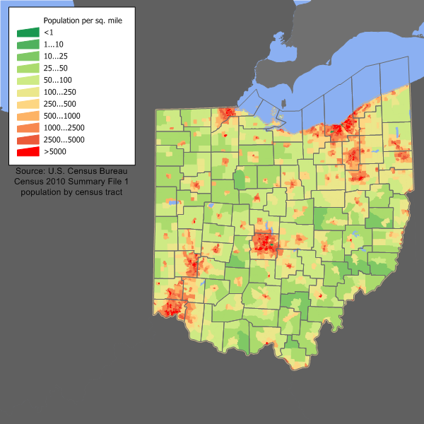
SC is pretty evenly balanced, but I think Ohio is probably the most well-balanced. The population in both states seems to be distributed pretty similarly:
I think the most unbalanced states could be Virginia,Georgia,Arizona,Colorado, Illinois
Virginia's not too bad. You've got Hampton Roads holding down the coast, Richmond holding the middle (somewhat), and NoVA holding the north. Roanoke, while not as big as any of those metro areas, serves as the hub of the mountainous region of the state.
Please register to post and access all features of our very popular forum. It is free and quick. Over $68,000 in prizes has already been given out to active posters on our forum. Additional giveaways are planned.
Detailed information about all U.S. cities, counties, and zip codes on our site: City-data.com.

 Please register to participate in our discussions with 2 million other members - it's free and quick! Some forums can only be seen by registered members. After you create your account, you'll be able to customize options and access all our 15,000 new posts/day with fewer ads.