Welcome to City-Data.com Forum!
U.S. CitiesCity-Data Forum Index
Go Back   City-Data Forum > U.S. Forums > General U.S.
 [Register]
Please register to participate in our discussions with 2 million other members - it's free and quick! Some forums can only be seen by registered members. After you create your account, you'll be able to customize options and access all our 15,000 new posts/day with fewer ads.
View detailed profile (Advanced) or search
site with Google Custom Search

Search Forums  (Advanced)
Reply Start New Thread
 
Old 06-05-2022, 01:36 PM
 
2,117 posts, read 1,739,523 times
Reputation: 2117

Advertisements

Quote:
Originally Posted by OyCrumbler View Post
It's just barely visible, but parts of Penobscot Bay is under the same oceanic Koppen climate classification as Brittany is.

I can't see any part of Maine having an oceanic climate...makes no sense. Would love to see hard data for these places rather than a picture. The only place in the lower 48 with a similar climate is going to be western Washington. Nowhere on the east coast is going to have a similar climate. This has been discussed many many times over on the weather forum.
Reply With Quote Quick reply to this message

 
Old 06-06-2022, 08:20 AM
 
Location: In the heights
37,153 posts, read 39,404,784 times
Reputation: 21252
Quote:
Originally Posted by fluffydelusions View Post
I can't see any part of Maine having an oceanic climate...makes no sense. Would love to see hard data for these places rather than a picture. The only place in the lower 48 with a similar climate is going to be western Washington. Nowhere on the east coast is going to have a similar climate. This has been discussed many many times over on the weather forum.
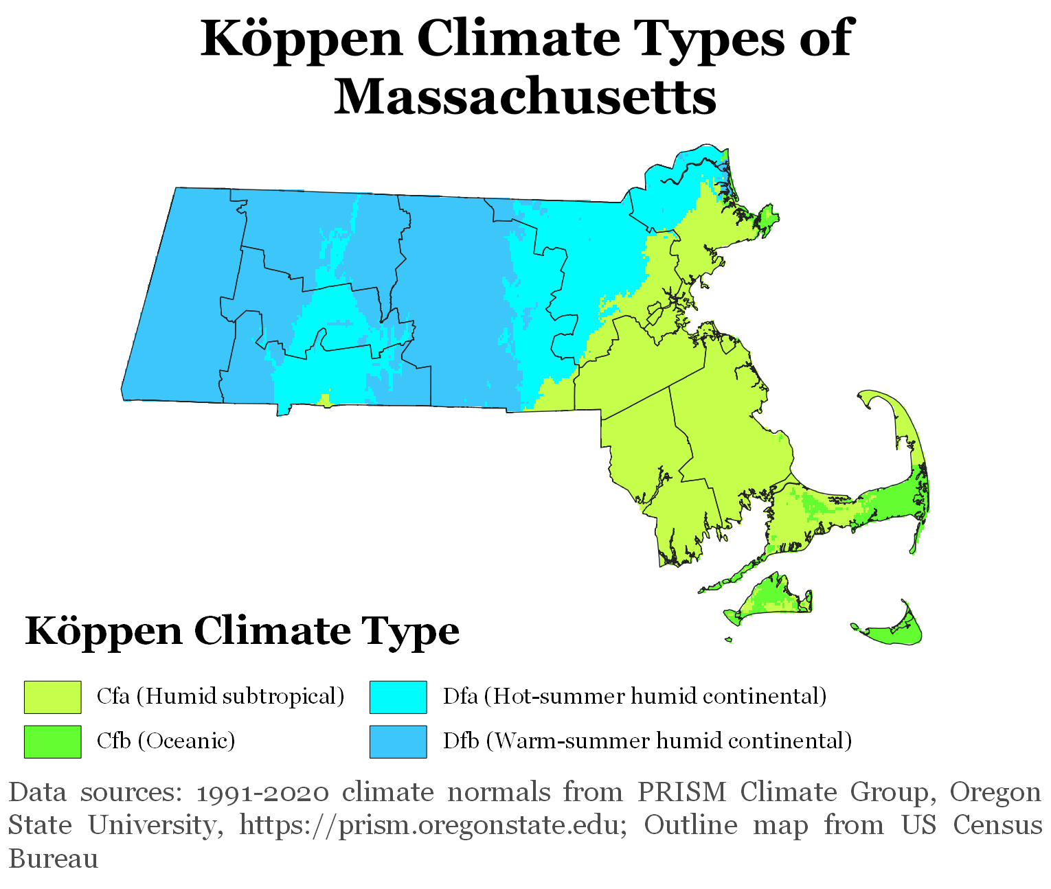
Yea, it is a bit weird. I do think places surrounded by water higher up in the north like Nantucket, Massachusetts and higher elevation parts of the southern reaches of the Appalachians like Waynesville, North Carolina technically do hit the temperature bands that the Koppen system puts under oceanic with the coldest monthly daily mean at or above freezing and the hottest month under 72F.

The odd thing is that these maps on wikipedia also put places surrounded by the ocean as far up north as Maine in there and even a narrow strip of the southeastern shore of Lake Erie (a small strip running along the lakefront of two counties in Ohio, one in Pennsylvania, and two in New York). Supposedly these maps are grabbing their temperature data from here: https://prism.oregonstate.edu/

What I think is possibly an explanation for this are differences in what years these are grabbing the average months from and over how many years that data is averaged and the time step used as a lot of these places are very close to the edge of being oceanic climate with a coldest month average sometimes being just slightly colder than freezing or the hottest month just slightly warmer than 72F. I've mentioned the tip of the southern fork of Long Island (like out in Montauk) where you can see that from what Wikipedia's entry is citing and for the timespan of 1991-2020 has it just slightly off of falling technically under oceanic due to July in their counting at an average of 73.2F and August at 72.9F which for a localized area is a pretty small distinction (and it's coldest monthly average for January being 33.7F which is just within the lower bounds).

As for what GeoffD said about the coast of Brittany and Penobscot Bay, I think saying they can be quite similar in terms of climate isn't necessarily that far off because they are certainly parts where the monthly daily means are fairly close to each other especially since his reference for Maine was during the summer months and within a pretty narrow band, though like you, I think something peculiar is going on for that to be technically under oceanic in the Koppen scheme.

Last edited by OyCrumbler; 06-06-2022 at 08:42 AM..
Reply With Quote Quick reply to this message
 
Old 06-06-2022, 09:16 AM
 
Location: Seattle WA, USA
5,699 posts, read 4,929,764 times
Reputation: 4943
@OyCrumbler, the reason why the maps are not “accurate” is because whoever created them was using Koppens original threshold of -3C, considering that Koppen lived in St. Petersburg Russia, it makes sense he would use such a low threshold to distinguish places that have consistently “real” snowy winters from those that don’t. But now days most people use 0C (freezing point) as the threshold, I guess the map maker didn’t get the memo?
Reply With Quote Quick reply to this message
 
Old 06-06-2022, 05:17 PM
 
Location: In the heights
37,153 posts, read 39,404,784 times
Reputation: 21252
Quote:
Originally Posted by grega94 View Post
@OyCrumbler, the reason why the maps are not “accurate” is because whoever created them was using Koppens original threshold of -3C, considering that Koppen lived in St. Petersburg Russia, it makes sense he would use such a low threshold to distinguish places that have consistently “real” snowy winters from those that don’t. But now days most people use 0C (freezing point) as the threshold, I guess the map maker didn’t get the memo?
I can believe that, though I didn't see where that was stated. Where did you find that?

Was what I wrote about the Koppen system putting under oceanic places with the coldest monthly daily mean at or above freezing and the hottest month under 72F accurate? If that's true, then wherever the wikipedia links for Nantucket and Waynesville in regards to their temps do technically fall under oceanic and are east of the Mississippi, right?
Reply With Quote Quick reply to this message
 
Old 06-07-2022, 12:27 AM
 
Location: Seattle WA, USA
5,699 posts, read 4,929,764 times
Reputation: 4943
Quote:
Originally Posted by OyCrumbler View Post
I can believe that, though I didn't see where that was stated. Where did you find that?

Was what I wrote about the Koppen system putting under oceanic places with the coldest monthly daily mean at or above freezing and the hottest month under 72F accurate? If that's true, then wherever the wikipedia links for Nantucket and Waynesville in regards to their temps do technically fall under oceanic and are east of the Mississippi, right?
It has been discussed on the weather forum, I guess I don’t know for sure, as I don’t see the threshold mentioned in the legend, but it’s the only way to explain why the map maker would have Boston as Cfa (humid subtropical)! But yes in theory the upper limits would be accurate so those “oceanic” coloured areas should be Dfb (warm-summer humid continental)


And I just looked up Chatham, MA, and surprisingly it’s actually almost oceanic with a minimum mean of 31.7F and highest mean of 69.5F

*oh and yes Nantucket does pass the threshold (33.1F), so yes it is oceanic after all.

Last edited by grega94; 06-07-2022 at 12:39 AM..
Reply With Quote Quick reply to this message
Please register to post and access all features of our very popular forum. It is free and quick. Over $68,000 in prizes has already been given out to active posters on our forum. Additional giveaways are planned.

Detailed information about all U.S. cities, counties, and zip codes on our site: City-data.com.


Reply
Please update this thread with any new information or opinions. This open thread is still read by thousands of people, so we encourage all additional points of view.

Quick Reply
Message:


Over $104,000 in prizes was already given out to active posters on our forum and additional giveaways are planned!

Go Back   City-Data Forum > U.S. Forums > General U.S.

All times are GMT -6.

© 2005-2024, Advameg, Inc. · Please obey Forum Rules · Terms of Use and Privacy Policy · Bug Bounty

City-Data.com - Contact Us - Archive 1, 2, 3, 4, 5, 6, 7, 8, 9, 10, 11, 12, 13, 14, 15, 16, 17, 18, 19, 20, 21, 22, 23, 24, 25, 26, 27, 28, 29, 30, 31, 32, 33, 34, 35, 36, 37 - Top