Please register to participate in our discussions with 2 million other members - it's free and quick! Some forums can only be seen by registered members. After you create your account, you'll be able to customize options and access all our 15,000 new posts/day with fewer ads.
I love these kinds of debates And I'm just eating up all the maps. I love maps.
Sorry to beat a dead horse, but...
If you've read my posts on the "What makes the South 'Southern'" and "Do people in Maryland consider themselves North, South or in between?" threads then y'all probably know my opinion on my home state. But I have to buy into the Wikipedia map. I take a more inclusive definition - everything that has some red in it is in the South, with the red striped states partially so The only state I might not include is Delaware. True, membership in the CSA is a key factor, but US states that sent men to fight with the Confederate army can't be completely thrown out, at least on an historical basis. That's why I hesitate to include Delaware - out of all the Border States, it was the only state where support for the Confederate cause was lukewarm at best. The Mason-Dixon line also, technically, divides Maryland (and West Virginia) not only from Pennsylvania but Delaware as well (oh boy, another map!):
Interesting history of the M-D Line: it was meant to settle land disputes between the Penn family and the family of Lord Baltimore. Frankly, I think Maryland got stiffed, but I would think that, wouldn't I?
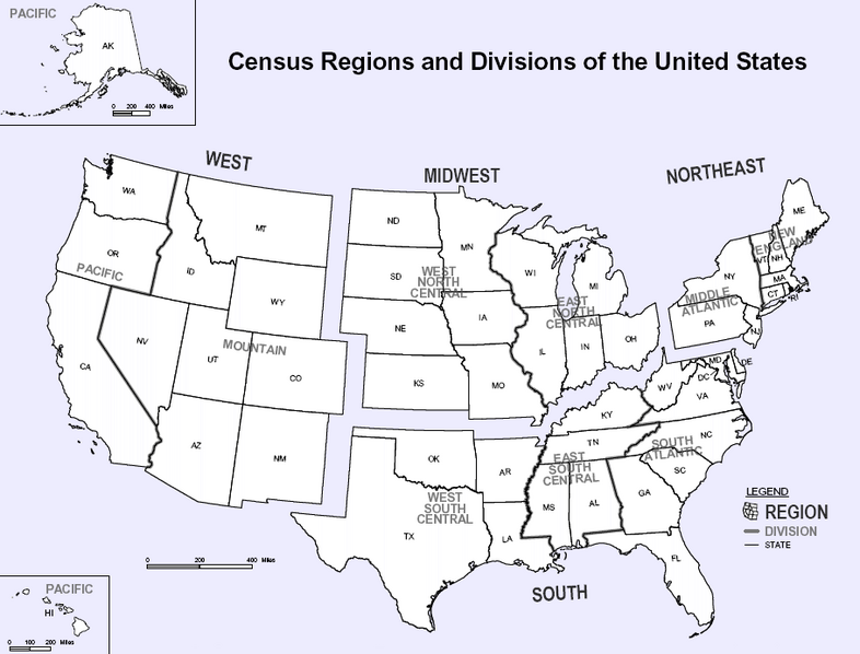
Another map to add to the discussion, the US Census Dept's official map of US regions. Apart from Missouri, which many posters I have read vociferously insist is Midwest, now if not always, it's pretty inclusive:
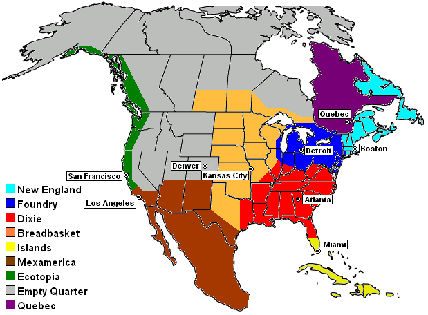
Finally I offer up one last map, which I have seen drawn slightly differently. It slices states up by cultural lines instead of just lumping whole states together in a region:
This was from a book written by Joel Garreau called The Nine Nations of North America (1981). It argued for specific regions that cut across state and national borders, carving up Texas into at least three pieces, lumping it in with the South, Southwest and Midwest (or as they call them, Dixie, Mexamerica and the Breadbasket). I've seen even more particular versions of this map, just to make it even more confusing. Has anyone seen this last map? I'm curious.
The Nine Nations of North America puts WAY too much Dixie influence in Illinois, it doesn't extend nearly that far north. Where Missouri is concerned, there is zero Dixie influence anywhere near St. Louis. The red parts in Missouri, Illinois, and Indiana need to be clipped if not in half at least a good quarter and moved about 50-100 miles to the south. Texas has 0 Midwestern characteristics to it at all, so I have no clue why anybody would make the argument for including it in. I for one am positive that the Nine Nations of North America has it wrong where Illinois and Missouri are concerned. Yes, there are pockets that could perhaps fit in with Dixie, but they are MUCH farther south than that map indicates. I don't feel like I'm in Dixie until I'm at least 100 miles south of St. Louis. The pockets of Dixie that the Nine Nations of North America labels in the Midwest are flat out wrong. Illinois has almost 0 Southern influence until maybe around Mount Vernon, but it's not truly Dixie until below Carbondale. When all else fails, go to Southern American English to decide what is the South and what isn't. That to me is the best indicator of the South. As you can clearly see, it occupies a very small amount of Missouri, so unless around 15-20% of Missouri having a Southern dialect makes it a Southern state, Missouri is clearly not Southern using this arguments. Also, being a historic border state IMO is not a way to argue for a state being part of the south. the border states during the Civil War and before it were divided and in a category of their own. The border states, IMO, were never part of the South unless they joined it after the Civil War, like Kentucky did. I also don't agree with Oklahoma being a Southern state. Oklahoma is far too ambiguous to have a clear identity. It is Southwestern and Southern. Texas I think has a pretty clear identity as a Southern state but it also has a lot of Southwestern influence to it. West Virginia IMO doesn't hav a clear identiy to it all. My argument of these still being border states is because these are the only ones which truly do not seem to lean more towards a single region than any other region. That is what defines a border state. It should be further noted that the Mason-Dixon line is also the Ohio River all the way to where it hits the Mississippi and then in sensible thinking that latitude across Missouri where the Ohio flows into the Mississippi. I don't consider Maryland or Delaware southern at all...they were border states before the Civil War, something else after. Maryland and Delaware clearly are part of the Mid-Atlantic region today (Maryland, Delaware, Pennsylvania, New Jersey, New York). Kentucky clearly fits in the best as a Southern state, Missouri the best as a Midwestern state. All things taken into account, this where all these states fit in best.
You have got to be kidding. This map has to be the biggest load of bs I've encountered in quite a while. Dallas and San Antonio considered Midwestern? Half of Illinois and Indiana is Southern? LMAO!!!
West Virginia IMO doesn't hav(sic) a clear identiy(sic) to it all.
Well, if you knew more about West Virginia maybe it would have a clear identity. West Virginia gave half of its soldiers and two-thirds of its territory to the Confederacy, far more than any other border state. As far as Colts map goes, the 2000 Census has a map of self-identified ethnic groups by county. The curious thing about it is that the nebulous group they called "American" repeats Colts map pretty well, even 140 years after the Civil War, though it includes parts of southern Ohio also. It should also be remembered that these northern states were centers of the Copperhead movement.
You have got to be kidding. This map has to be the biggest load of bs I've encountered in quite a while. Dallas and San Antonio considered Midwestern? Half of Illinois and Indiana is Southern? LMAO!!!
I agree.
I read this guy's book --Nine Nations of North America-- I believe that's the title, but I felt like the author didn't know what he was talking about.
when i visited east texas (new boston/texarkana area) this past spring it definately had a heavy southern appeal to it. it was a slightly different feel though when i got to ft. worth but maybe just because i was in the city. the dallas/ft. worth area still felt more southern then midwestern like to me though and being from the south i felt right at home. just my .02.
The Modern South (Dixie Land) technically consists of 17 states plus the District of Columbia:
The Lower (Deep) South-7 states:
South Carolina
Mississippi
Florida
Alabama
Georgia
Louisiana
Texas
The Middle (Mid) South-4 states:
Virginia
Arkansas
Tennessee
North Carolina
The Upper (Border) South-6 states:
Delaware
Maryland
West Virginia
Kentucky
Missouri
Oklahoma
The Confederate South (Dixie Land) consisted of 13 states-hence the 13 stars on the Confederate flag:
South Carolina
Mississippi
Florida
Alabama
Georgia
Louisiana
Texas
Virginia
Arkansas
Tennessee
North Carolina
Missouri
Kentucky
These states are the South. You can't divide a state in two if it's one single state. South Florida is part of Dixie. Similarities with the Caribbean landscape and foliage has nothing to do with being Southern or not. The Caribbean influence of people on South Florida is mainly confined to Miami, West Palm Beach, and that whole strip. The Everglades towns that dot the map are clearly Southern, drawl and all! Missouri is a Southern state with Northern cultures just like Illinois, Indiana, and Ohio are Northern states with Southern cultures.
You've obviously never been to Missouri. Missouri is not a Southern state. It was NEVER 100% Southern. It started out as a border state and then essentially became a more Northern state after the Civil War. Same with Maryland and Delaware. Kentucky and West Virginia became more Southern. The best way to describe Missouri these days is a Midwestern state with Southern culture. Also, Missouri did not really secede from the Union...the government that seceded from Missouri was not recognized by the vast majority of Missourians. Kentucky came very close to seceding...in fact, the Russellville Convention had 63 Kentucky counties present.
Ditto on the thumbs down as concerns the extent of "Dixie" influence into the north and the "Breadbasket" (Midwestern) to the south on the "Nine Nations" map.
As ajf131 said, there is just about zero Midwestern influence in Texas. The only POSSIBLE exeption to this might be the VERY upper tier of counties in the Texas Panhandle (above Amarillo) and even there it would be diluted as compared to the true Midwest states. Another isolated area might be some places in the DFW area where there has been a heavy influx of northern immigration over the years. But this is an anamoly found in many large Southern cities.
Please register to post and access all features of our very popular forum. It is free and quick. Over $68,000 in prizes has already been given out to active posters on our forum. Additional giveaways are planned.
Detailed information about all U.S. cities, counties, and zip codes on our site: City-data.com.

 Please register to participate in our discussions with 2 million other members - it's free and quick! Some forums can only be seen by registered members. After you create your account, you'll be able to customize options and access all our 15,000 new posts/day with fewer ads.


 And I'm just eating up all the maps. I love maps.