Please register to participate in our discussions with 2 million other members - it's free and quick! Some forums can only be seen by registered members. After you create your account, you'll be able to customize options and access all our 15,000 new posts/day with fewer ads.
"Sub tropical" for now. Expected to move southwest into Florida then back NorthEast to the east coast and out.
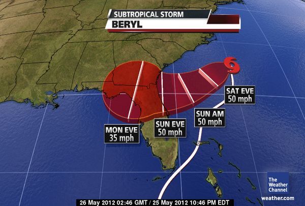
SUBTROPICAL STORM BERYL ADVISORY NUMBER 2 NWS NATIONAL HURRICANE CENTER MIAMI FL AL022012 500 AM EDT SAT MAY 26 2012
...BERYL MOVING WEST-SOUTHWESTWARD...TROPICAL STORM CONDITIONS EXPECTED IN THE WARNING AREA ON SUNDAY...
SUMMARY OF 500 AM EDT...0900 UTC...INFORMATION ----------------------------------------------LOCATION...32.3N 75.6W ABOUT 180 MI...285 KM SE OF CAPE FEAR NORTH CAROLINA ABOUT 260 MI...415 KM E OF CHARLESTON SOUTH CAROLINA MAXIMUM SUSTAINED WINDS...45 MPH...75 KM/H PRESENT MOVEMENT...WSW OR 255 DEGREES AT 5 MPH...7 KM/H MINIMUM CENTRAL PRESSURE...1001 MB...29.56 INCHES
------------
DISCUSSION AND 48-HOUR OUTLOOK ------------------------------AT 500 AM EDT...0900 UTC...THE CENTER OF SUBTROPICAL STORM BERYL WAS LOCATED NEAR LATITUDE 32.3 NORTH...LONGITUDE 75.6 WEST. BERYL IS MOVING TOWARD THE WEST-SOUTHWEST NEAR 5 MPH...7 KM/H. A WEST-SOUTHWEST OR SOUTHWEST MOTION WITH AN INCREASE IN FORWARD SPEED IS EXPECTED THROUGH SUNDAY...WITH A TURN TOWARD THE WEST EXPECTED ON SUNDAY NIGHT. ON THE FORECAST TRACK THE CENTER OF BERYL WILL APPROACH THE COAST IN THE WARNING AREA ON SUNDAY.
MAXIMUM SUSTAINED WINDS REMAIN NEAR 45 MPH...75 KM/H...WITH HIGHER GUSTS. A LITTLE STRENGTHENING IS POSSIBLE DURING THE NEXT DAY OR SO.
TROPICAL STORM FORCE WINDS EXTEND OUTWARD UP TO 115 MILES...185 KM FROM THE CENTER.
THE ESTIMATED MINIMUM CENTRAL PRESSURE IS 1001 MB...29.56 INCHES
It looks like this storm is heading exactly where they need it so thats some very good news. Lets hope its a good drencher and the winds are as minimal as they should likely be.
"Sub tropical" for now. Expected to move southwest into Florida then back NorthEast to the east coast and out.
SUBTROPICAL STORM BERYL ADVISORY NUMBER 2 NWS NATIONAL HURRICANE CENTER MIAMI FL AL022012 500 AM EDT SAT MAY 26 2012
...BERYL MOVING WEST-SOUTHWESTWARD...TROPICAL STORM CONDITIONS EXPECTED IN THE WARNING AREA ON SUNDAY...
SUMMARY OF 500 AM EDT...0900 UTC...INFORMATION ----------------------------------------------LOCATION...32.3N 75.6W ABOUT 180 MI...285 KM SE OF CAPE FEAR NORTH CAROLINA ABOUT 260 MI...415 KM E OF CHARLESTON SOUTH CAROLINA MAXIMUM SUSTAINED WINDS...45 MPH...75 KM/H PRESENT MOVEMENT...WSW OR 255 DEGREES AT 5 MPH...7 KM/H MINIMUM CENTRAL PRESSURE...1001 MB...29.56 INCHES
------------
DISCUSSION AND 48-HOUR OUTLOOK ------------------------------AT 500 AM EDT...0900 UTC...THE CENTER OF SUBTROPICAL STORM BERYL WAS LOCATED NEAR LATITUDE 32.3 NORTH...LONGITUDE 75.6 WEST. BERYL IS MOVING TOWARD THE WEST-SOUTHWEST NEAR 5 MPH...7 KM/H. A WEST-SOUTHWEST OR SOUTHWEST MOTION WITH AN INCREASE IN FORWARD SPEED IS EXPECTED THROUGH SUNDAY...WITH A TURN TOWARD THE WEST EXPECTED ON SUNDAY NIGHT. ON THE FORECAST TRACK THE CENTER OF BERYL WILL APPROACH THE COAST IN THE WARNING AREA ON SUNDAY.
MAXIMUM SUSTAINED WINDS REMAIN NEAR 45 MPH...75 KM/H...WITH HIGHER GUSTS. A LITTLE STRENGTHENING IS POSSIBLE DURING THE NEXT DAY OR SO.
TROPICAL STORM FORCE WINDS EXTEND OUTWARD UP TO 115 MILES...185 KM FROM THE CENTER.
THE ESTIMATED MINIMUM CENTRAL PRESSURE IS 1001 MB...29.56 INCHES
Isn't it early for hurricane season? I was under the impression that the season didn't begin until late summer. Hope it goes out to sea before it hits Florida or anyone else! Keep us informed.
Isn't it early for hurricane season? I was under the impression that the season didn't begin until late summer. Hope it goes out to sea before it hits Florida or anyone else! Keep us informed.
Yes, starts June 1st. I guess atmosphere is primed and ready. Its happened in the past in may but obviously out of the norm.
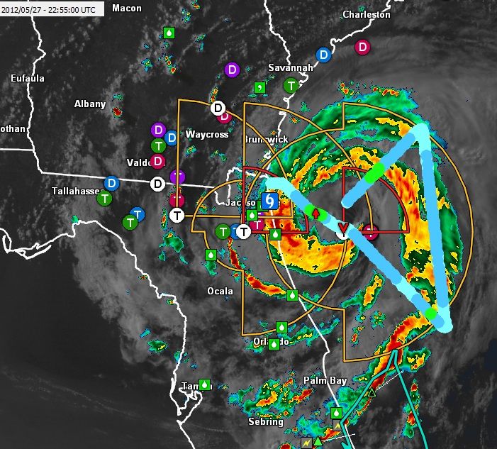
Air Force Reconnaissance aircraft in Tropical Storm Beryl indicated just moments ago that the storm is almost a Category 1 hurricane. With sustained winds of near 70mph and higher gusts, Beryl can easily become a hurricane before making landfall near Jacksonville, FL late tonight. This could be a life threatening situation and residents in northeastern FL , coastal GA, and coastal SC should rush to completion their storm preparations and evacuate if necessary.
Hurricane Able was the strongest recorded hurricane outside of the typical Atlantic hurricane season. The first tropical cyclone in 1951, Able developed from a trough of low pressure on May 15 about 300 miles (480 km) south of Bermuda. Initially subtropical in nature, Able acquired tropical characteristics as it moved over the warm waters of the Gulf Stream and attained hurricane status on May 17 off the coast of Florida
Please register to post and access all features of our very popular forum. It is free and quick. Over $68,000 in prizes has already been given out to active posters on our forum. Additional giveaways are planned.
Detailed information about all U.S. cities, counties, and zip codes on our site: City-data.com.

 Please register to participate in our discussions with 2 million other members - it's free and quick! Some forums can only be seen by registered members. After you create your account, you'll be able to customize options and access all our 15,000 new posts/day with fewer ads.