Please register to participate in our discussions with 2 million other members - it's free and quick! Some forums can only be seen by registered members. After you create your account, you'll be able to customize options and access all our 15,000 new posts/day with fewer ads.
TD7 STILL hasn't become Gordon yet and is supposed to dissipate soon, and 93L is now only 20% chance instead of 50%. So much for activity... lol.
lol. Hows the SAL looking lately? Things did get quiet again. Thanks for the updates!
I Posted this May 20th. How am I doing so far?
Quote:
Originally Posted by Cambium
So only 7 storms formed and 4 became a hurricane on average.
Reason why forecasts have low confidence on an active season this year is the atmosphere is not condusive for development.
lol. Hows the SAL looking lately? Things did get quiet again. Thanks for the updates!
I Posted this May 20th. How am I doing so far?
The inactivity might be short-lived, a few models are showing a monster hurricane in about 2 weeks, whether the forecast is accurate or not I don't know, but it sure looks menacing. Check my previous post on page 2, all the way at the bottom, to see the model and a massive wave in the middle of Africa that might become the possible "big bad wolf" hurricane of the year.
As for your post, they're saying it's not going to be as active as the past two seasons because an El Nino is developing or already developed. Even then though, it's still supposed to be "average", so not quite inactive.
looks like current winds will not allow any storms to the United States unless they come up the Gulf. I think we are going to end up with lots of named storms kind of just floating around the Atlantic, maybe Bermuda could take a hit but don't see much else.
2. DISORGANIZED SHOWER AND THUNDERSTORM ACTIVITY CONTINUES IN ASSOCIATION WITH A TROPICAL WAVE LOCATED IN THE EASTERN ATLANTIC BETWEEN THE CAPE VERDE ISLANDS AND THE WEST COAST OF AFRICA. SOME SLOW DEVELOPMENT OF THIS SYSTEM IS POSSIBLE DURING THE NEXT FEW DAYS. THIS SYSTEM HAS A LOW CHANCE...10 PERCENT...OF BECOMING A TROPICAL CYCLONE DURING THE NEXT 48 HOURS AS IT MOVES TOWARD THE WEST AT 15 TO 20 MPH. Look what the Euro's doing with it.
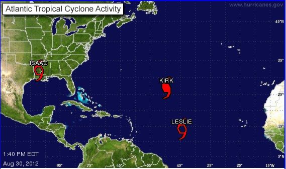
Looks like Kirk will be an open water storm, but could get close to Bermuda. There is a systen further south in the Central Atlantic that has 90% of developing into a named storm in the next day or two.
8 named storms so far this August, tied for most active August ever with 2004. Doesn't look like we'll beat it though since nothing is forecasted to develop in the next two days. Still a very active season so far, so much for El Nino.
Also TS LESLIE has officially formed. Track says out to sea or Bermuda, but still too early to tell.
No thread on kirk. Sounds like both Leslie and Kirk rapidly strengthening out there.
...KIRK RAPIDLY STRENGTHENING OVER THE OPEN ATLANTIC...
SUMMARY OF 500 PM AST...2100 UTC...INFORMATION ----------------------------------------------LOCATION...28.2N 50.3W ABOUT 1065 MI...1715 KM NE OF THE NORTHERN LEEWARD ISLANDS ABOUT 1505 MI...2420 KM WSW OF THE AZORES MAXIMUM SUSTAINED WINDS...90 MPH...150 KM/H PRESENT MOVEMENT...NNW OR 330 DEGREES AT 13 MPH...20 KM/H MINIMUM CENTRAL PRESSURE...982 MB...29.00 INCHES
DISCUSSION AND 48-HOUR OUTLOOK ------------------------------AT 500 PM AST...2100 UTC...THE CENTER OF HURRICANE KIRK WAS LOCATED NEAR LATITUDE 28.2 NORTH...LONGITUDE 50.3 WEST. KIRK IS MOVING TOWARD THE NORTH-NORTHWEST NEAR 13 MPH...20 KM/H...AND THIS MOTION IS EXPECTED TO CONTINUE TONIGHT. A TURN TOWARD THE NORTH IS EXPECTED ON FRIDAY...FOLLOWED BY AN ACCELERATION TO THE NORTH-NORTHEAST FRIDAY NIGHT.
MAXIMUM SUSTAINED WINDS HAVE INCREASED TO NEAR 90 MPH...150 KM/H... WITH HIGHER GUSTS. KIRK IS A CATEGORY ONE HURRICANE ON THE SAFFIR-SIMPSON SCALE. ADDITIONAL STRENGTHENING IS FORECAST DURING THE NEXT COUPLE OF DAYS...AND KIRK COULD BECOME A CATEGORY TWO HURRICANE ON FRIDAY.
HURRICANE-FORCE WINDS EXTEND OUTWARD UP TO 15 MILES...30 KM...FROM THE CENTER...AND TROPICAL-STORM-FORCE WINDS EXTEND OUTWARD UP TO 70 MILES...110 KM.
Please register to post and access all features of our very popular forum. It is free and quick. Over $68,000 in prizes has already been given out to active posters on our forum. Additional giveaways are planned.
Detailed information about all U.S. cities, counties, and zip codes on our site: City-data.com.

 Please register to participate in our discussions with 2 million other members - it's free and quick! Some forums can only be seen by registered members. After you create your account, you'll be able to customize options and access all our 15,000 new posts/day with fewer ads.