Welcome to City-Data.com Forum!
U.S. CitiesCity-Data Forum Index
Go Back   City-Data Forum > General Forums > Weather > Hurricanes
 [Register]
Please register to participate in our discussions with 2 million other members - it's free and quick! Some forums can only be seen by registered members. After you create your account, you'll be able to customize options and access all our 15,000 new posts/day with fewer ads.
View detailed profile (Advanced) or search
site with Google Custom Search

Search Forums  (Advanced)
Reply Start New Thread
 
Old 10-21-2012, 12:46 PM
 
Location: Near the Coast SWCT
83,514 posts, read 75,277,900 times
Reputation: 16619

Advertisements

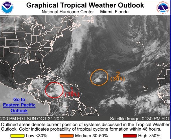
99L in the Carribean should beome TS Sandy soon and its the one that gets caught inside the trough and gets pulled into the NorthEast coast per some models.


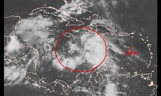
1. A BROAD AREA OF LOW PRESSURE...ASSOCIATED WITH A TROPICAL WAVE...ISPRODUCING A LARGE AREA OF SHOWERS AND THUNDERSTORMS OVER THECENTRAL CARIBBEAN SEA. ENVIRONMENTAL CONDITIONS ARE EXPECTED TO BECONDUCIVE FOR THE FORMATION OF A TROPICAL DEPRESSION DURING THENEXT COUPLE OF DAYS...AND THIS SYSTEM HAS A HIGH CHANCE...70PERCENT...OF BECOMING A TROPICAL CYCLONE DURING THE NEXT 48 HOURSAS IT MOVES SLOWLY WESTWARD AND BECOMES NEARLY STATIONARY WELLSOUTH OF JAMAICA. HEAVY RAINS FROM THIS DISTURBANCE ARE LIKELY TOSPREAD OVER JAMAICA...HISPANIOLA...AND EASTERN CUBA OVER THE NEXTSEVERAL DAYS. THESE RAINS COULD PRODUCE LIFE-THREATENING FLASHFLOODS AND MUD SLIDES...ESPECIALLY IN AREAS OF HIGH TERRAIN.
Reply With Quote Quick reply to this message

 
Old 10-21-2012, 12:56 PM
 
Location: Near the Coast SWCT
83,514 posts, read 75,277,900 times
Reputation: 16619
Sterring Currents. One thing is for sure... It will not go into the Gulf.

Since models have a system near the East coast they are saying its going to take the middle path..

http://tropic.ssec.wisc.edu/real-tim...lm1&zoom=&time=

Reply With Quote Quick reply to this message
 
Old 10-21-2012, 01:05 PM
 
Location: Near the Coast SWCT
83,514 posts, read 75,277,900 times
Reputation: 16619
Euro12z 10/21/12


GFS12z 10/21/12


Reply With Quote Quick reply to this message
 
Old 10-21-2012, 01:14 PM
 
Location: Near the Coast SWCT
83,514 posts, read 75,277,900 times
Reputation: 16619
Dont believe the models yet until they get more samples from this system... But the consistancy of them all is a bit interesting.
Reply With Quote Quick reply to this message
 
Old 10-21-2012, 01:25 PM
 
Location: Out in the stix
1,607 posts, read 3,090,219 times
Reputation: 1030
I still don't believe we will get a direct hit in the tri state area, maybe some rain etc etc but way too early to tell
Reply With Quote Quick reply to this message
 
Old 10-21-2012, 01:31 PM
 
Location: Near the Coast SWCT
83,514 posts, read 75,277,900 times
Reputation: 16619
Quote:
Originally Posted by ctwhitechin View Post
I still don't believe we will get a direct hit in the tri state area, maybe some rain etc etc but way too early to tell
The odds of another hurricane hitting the NorthEast has to be slim. Maybe someone has actual numbers for us.
Reply With Quote Quick reply to this message
 
Old 10-21-2012, 02:04 PM
 
Location: Near the Coast SWCT
83,514 posts, read 75,277,900 times
Reputation: 16619
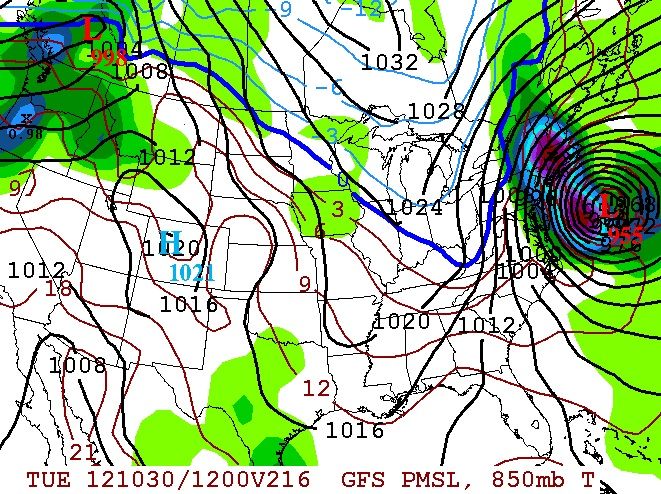
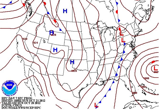
HPC Shows the Cyclone in the Atlantic as well now given the fact that all models do. This is the last frame in its loop. Timing of all features will be everything.

HPC Sea-level Pressures and Fronts through Day 7

Reply With Quote Quick reply to this message
 
Old 10-21-2012, 03:18 PM
 
Location: New York
11,326 posts, read 20,328,314 times
Reputation: 6231
This is looking a little scary, still too far out but this is definitely something to keep an eye on.
Reply With Quote Quick reply to this message
 
Old 10-21-2012, 03:26 PM
 
Location: Near the Coast SWCT
83,514 posts, read 75,277,900 times
Reputation: 16619
Couple of Tweets from Alan.

Meteorologist Allan Huffman has 10+ years of experience in weather forecasting and modeling with a Master’s Degree in meteorology from NC State University.
Raleigh, NC · http://www.examiner.com/x-4053-Raleigh-Weather-Examiner

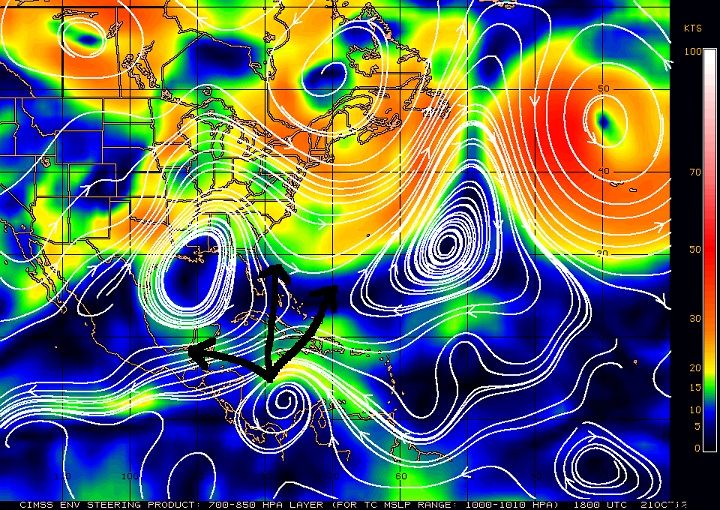
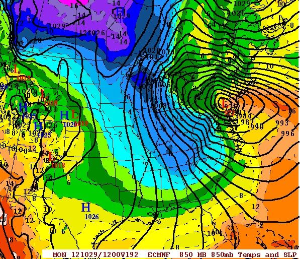
12z Euro showing it as well as last 3 runs of GFS. Whole east coast needs to watch, especially from Outer Banks north

A look at 12z Euro ensemble members show operational near the middle of envelope. Meaning phasing scenario is very much on table

What would a phase mean? It would mean that even though this storm would likely be transitioning from a tropical system to an extra-tropical

one. The strong trough will absorb the tropical energy and create a very intense cold-core or hybrid cyclone that will bring high winds,

heavy rain, coastal flooding etc. In short a huge impact event just before or on Halloween. Greatest threat Outer Banks to New Englad. But? The latest model ideas of driving the storm NW well inland would mean a widespread damaging event for much of the populated NE corridor

https://twitter.com/RaleighWx
Reply With Quote Quick reply to this message
 
Old 10-21-2012, 04:44 PM
 
Location: Near the Coast SWCT
83,514 posts, read 75,277,900 times
Reputation: 16619
Levi doesnt show the last Euro12z which phases a full storm but the video is worth it.

If your on facebook like his page. //www.facebook.com/tropicaltidbits?ref=stream


Tropical Tidbit for Sunday, October 21st, 2012 - YouTube#!
Reply With Quote Quick reply to this message
Please register to post and access all features of our very popular forum. It is free and quick. Over $68,000 in prizes has already been given out to active posters on our forum. Additional giveaways are planned.

Detailed information about all U.S. cities, counties, and zip codes on our site: City-data.com.


Reply
Please update this thread with any new information or opinions. This open thread is still read by thousands of people, so we encourage all additional points of view.

Quick Reply
Message:


Over $104,000 in prizes was already given out to active posters on our forum and additional giveaways are planned!

Go Back   City-Data Forum > General Forums > Weather > Hurricanes
Similar Threads

All times are GMT -6. The time now is 07:20 PM.

© 2005-2024, Advameg, Inc. · Please obey Forum Rules · Terms of Use and Privacy Policy · Bug Bounty

City-Data.com - Contact Us - Archive 1, 2, 3, 4, 5, 6, 7, 8, 9, 10, 11, 12, 13, 14, 15, 16, 17, 18, 19, 20, 21, 22, 23, 24, 25, 26, 27, 28, 29, 30, 31, 32, 33, 34, 35, 36, 37 - Top