Please register to participate in our discussions with 2 million other members - it's free and quick! Some forums can only be seen by registered members. After you create your account, you'll be able to customize options and access all our 15,000 new posts/day with fewer ads.
8Jul18 945pEDT/AST: Likely strongest part of storm remnants islands will see passing over Guadeloupe and parts of Dominica currently. Infrared satellite and radar shown below:
8Jul18 11pEDT/AST - No Tropical Storm force winds(39mph+) were reported from Dominica & Guadeloupe so TS advisories have been canceled. This is the last advisory the NHC will issue unless Beryl reorganizes near Bahamas or W Atlantic (low chance still). Archive of previous advisories can be found here: https://www.nhc.noaa.gov/archive/2018/BERYL.shtml?
9Jul18 2pEDT/AST - Remnants of Beryl now have a 50% chance of redevelopment as it turns North near Bahamas later this week. I believe it would retain the same name as long as its orgins can easily be traced back to the original Low of the named storm.
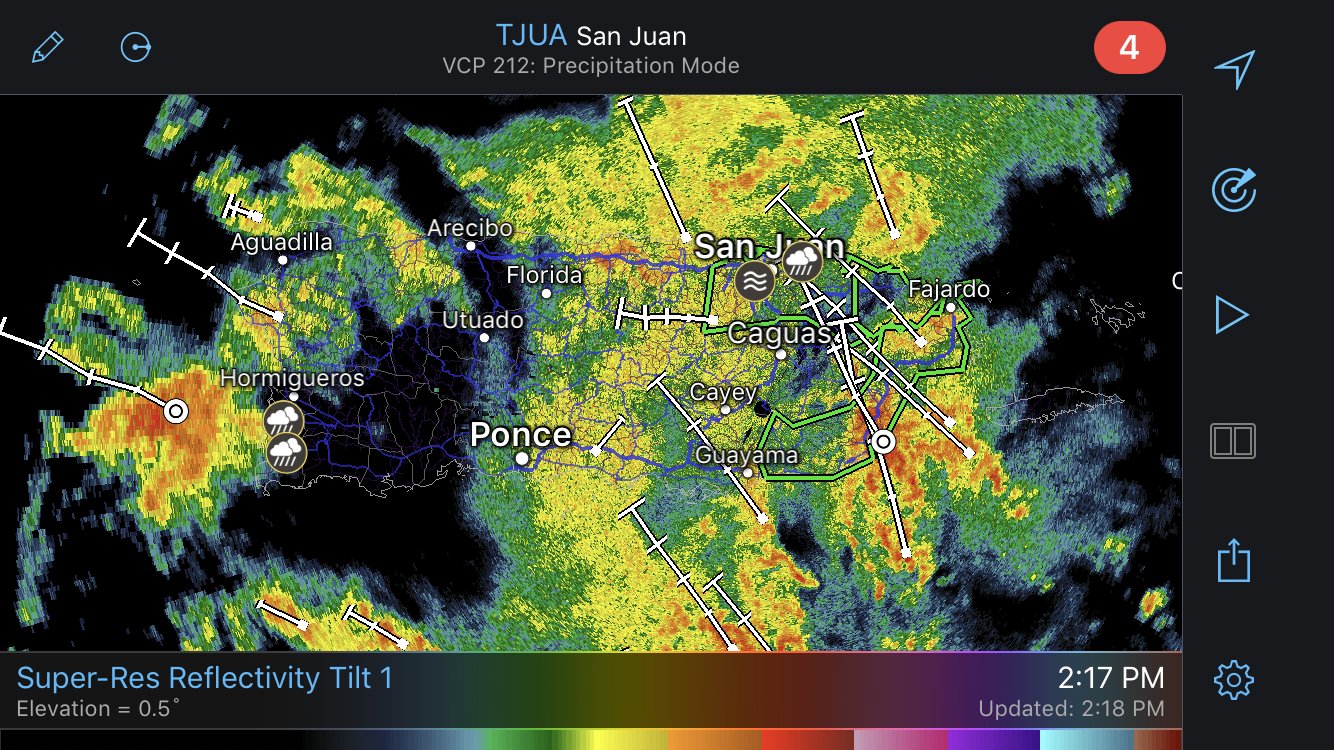
Puerto Rico radar showing scattered showers across a broad area, some flash flood warnings in effect (radar was restored to Puerto Rico in June 2018 after being destroyed by Maria in September of 2017):
Don't want to leave you completely empty handed so I believe the Euro(ECMWF) is twice a day around 3am/pmEDT (0z/12z initialized runs (#z = Zulu(UTC+0) time model started running data, data comes out hours later). GFS 4 times a day, initializing at 0z,6z,12z & 18z , every 6hrs, data starts a couple hours before the Euro. There are several products that come out with each run including tropical system storm path main model run and the ensembles, or multiple models, that make that up, and various other products.
Thanks for that. Last year, I made it a habit to check the GFS and Euro often, especially when Irma was threatening the East Coast as well as the year before when Matthew did the same. I'm no expert, but since I live close enough to the coast that if the path is "close" about 2-3 days out it doesn't matter what the estimated strength is - I need to bail.
Thanks for that. Last year, I made it a habit to check the GFS and Euro often, especially when Irma was threatening the East Coast as well as the year before when Matthew did the same. I'm no expert, but since I live close enough to the coast that if the path is "close" about 2-3 days out it doesn't matter what the estimated strength is - I need to bail.
Ya, I used to watch them more often as they came out but the back and forth model swings started driving me crazy so now I just wait until someone post on social media somewhere or here since someone always seems to have them. Always good to know what your limit for storms is, or what would make you evacuate in advance so its not as stressful or anxiety filled as much. The wondering if should go or not gets to a lot of people last minute. Have a plan early, it makes a difference. I still have a lot to learn about storms but I just try to learn at least something new each year as time allows.
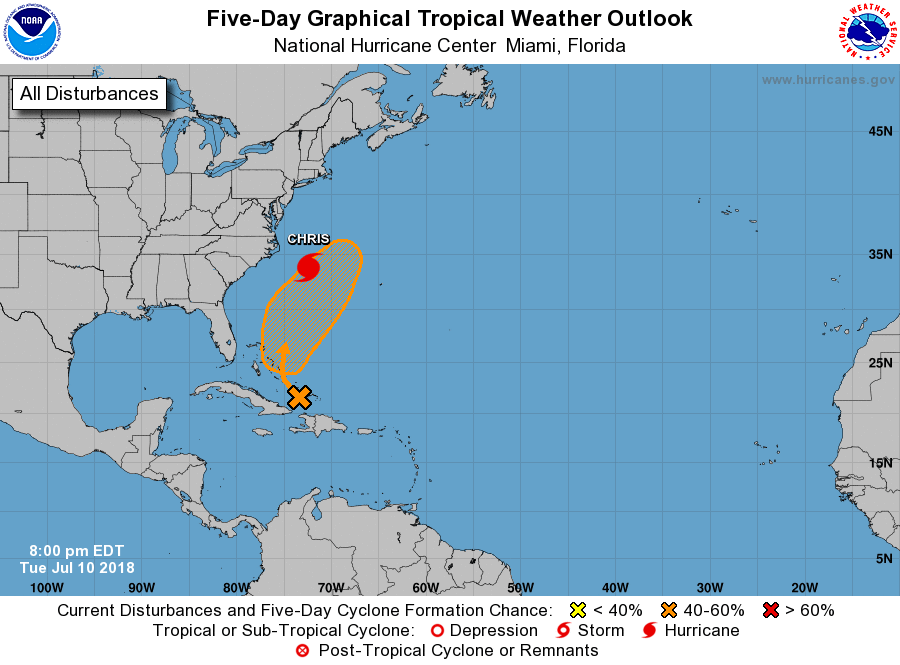
8pEDT NHC evening tropics update shows 50% chance Beryl remnants will try and reform as it curves up and out:
11July18 8pEDT - NHC's evening tropical update still has Beryl remnants at 50% chance development later this week into the weekend as it looks to follow Chris out to sea:
12July18 8aEDT NHC's tropical update still go's with 50% chance of development next few days, and potential development area ticked a little more Westward. NHC: "conditions could become a little more favorable over the weekend when the disturbance will be moving northward over the warm waters of the western Atlantic and interacting with a strong upper-level trough."
Not much to Beryl remnants at the moment (Water vapor image):
14July18 1pEDT/AST: Subtropical Storm Beryl regenerates North of Bermuda. Estimated winds 40mph, moving NE 12mph, pressure 1010mb. Per NHC: " the upper-level trough is likely contributing baroclinic energy to the system, and thus the regenerated Beryl is being called a subtropical cyclone rather than a tropical cyclone". Little to no further intensification, may effect Newfoundland, then out to sea. No US threat.
14July18 11pEDT/AST: Winds 40mph, moving NNE 13mph, pressure 1010mb.
Please register to post and access all features of our very popular forum. It is free and quick. Over $68,000 in prizes has already been given out to active posters on our forum. Additional giveaways are planned.
Detailed information about all U.S. cities, counties, and zip codes on our site: City-data.com.

 Please register to participate in our discussions with 2 million other members - it's free and quick! Some forums can only be seen by registered members. After you create your account, you'll be able to customize options and access all our 15,000 new posts/day with fewer ads.