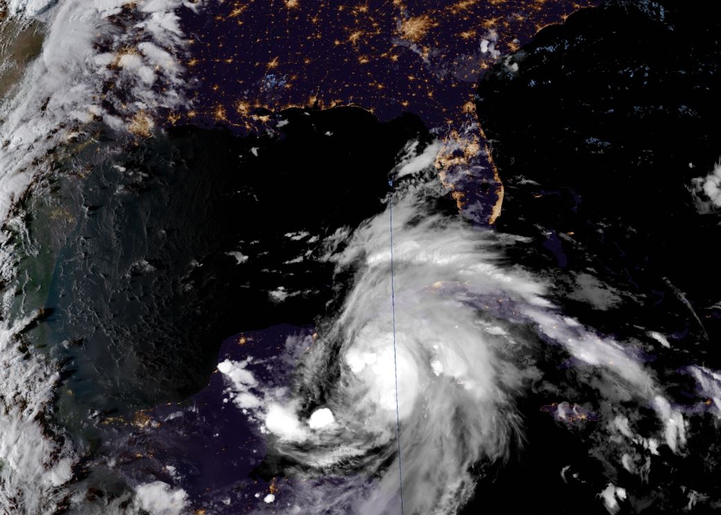
7Oct18 4pCDT/5pEDT: Winds 50mph(85km/h), moving NNE 3mph(6km/h), pressure 999mb. Tropical Storm force winds extend up to 205miles(335km) from storm center, mainly its East side. Expected to become a Hurricane Monday or Tuesday.
Current Warnings:
-Tropical Storm Warning (winds 39+mph within 24hours or less these locations now) Tulum to Cabo Catoche (includes Cozumel) Mexico and Pinar del Rio & the Isle of Youth Cuba.
Rains:
-3-7inches, isolated 12inches W Cuba.
-2-4inches Yucatan Peninsula, Belize.
--Life-threatening floods/mudslides possible.
-These rains will move up into the US as we go through the week. .**This will be track dependent and continue to adjust, do NOT focus on specific points/locations yet, but note the potential that is building**, but in general, preliminary guidance suggest scattered totals of:
NOAA current 7-day chart:

Euro showing possible 12inches plus some locations **again totals are all track dependent!**

Some areas of the Carolina's are still dealing with affects from Florence flooding. Any additional rainfall is not welcome. On the other hand other portions of SC and GA really need the rains.
Storm Surge
The threat for storm surge is increasing for the US Gulf Coast. Surge is like a really high tide with waves on top, and stretches inland up rivers, bays, and sometimes even reverse up through street storm drains, etc. It is on average the most deadly part of a hurricane. Surge is generally highest with a hurricane at the storm center and points Eastward of it with onshore winds pushing water in as the storm makes landfall. It starts rising hours before the center arrives though. It can vary greatly location to location based on many factors such as barrier islands, shapes of bays, high or low tide times, etc. The shallower the waters at the coast and the stronger the storm, then in general the greater the surge height.
Official storm surge maps for Michael will be released once Tropical Storm or Hurricane Watch/Warnings are posted for the US coast line which will likely be Monday or Tuesday, at the 5 or 11 am/pm EDT updates. These storm surge maps will be updated as needed about 30 to 90minutes AFTER each main 5 & 11 am/pm EDT update.
Tornado:
Small brief lived tornadoes are very common in land-falling tropical systems as rain bands come onshore and move inland. They are mostly found on the NE side/corner of the storm. The threat for these will increase as the storm approaches the US Gulf coast and well after landfall into the SE US.
Winds:
Too early to know what winds will be with storm, and will be very track dependent. Models have been increasing their wind speeds for the storm with a few bringing it to Cat2 or Cat3 at landfall now. It is still too early to know what it will be. With a quick moving storm strong winds may carry well inland becoming a tree/power concern. Please keep an eye on the storm if anywhere in the SE US.

Intensity Guidance modeling:

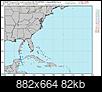
Euro main model looks like a Cat2/3 into the FL coast:
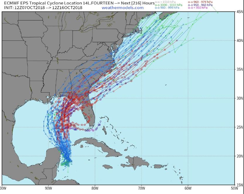
Euro model members that make up the main model (Ensembles):
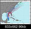
The official cone map (where center of storm could be in time) by the humans at NHC who actually have a pretty good track record:

And possible arrival time of Tropical Storm force winds (39+mph) which is considered the you are done preparing/evacuating and where you will be to ride this storm out threshold as those winds usher in power/tree problems.

NHC now going with a 100mph Cat2 hurricane at landfall. This may continue to adjust, please keep up to date with changing conditions of this system.

 Please register to participate in our discussions with 2 million other members - it's free and quick! Some forums can only be seen by registered members. After you create your account, you'll be able to customize options and access all our 15,000 new posts/day with fewer ads.