Please register to participate in our discussions with 2 million other members - it's free and quick! Some forums can only be seen by registered members. After you create your account, you'll be able to customize options and access all our 15,000 new posts/day with fewer ads.
HOUSTON - Tropical Storm Gordon continues to drench parts of South Florida as it is moving into the open Gulf of Mexico later this evening. What we know
- Tropical Storm Gordon is moving into the Gulf of Mexico today with sustained winds of 50 mph, gusts to 65 mph and will strengthen moving through water with temperatures close to 90 degrees.
- Landfall is expected overnight Tuesday into Wednesday morning well east of SE TX somewhere along the LA/MS coastline as strong as potentially a Category 1 hurricane.
- Impacts to SE Texas appear to be minimal at this point with a slight chance of some increased surf and rip current mid-week.
- A tropical storm warning has been issued from Shell Island, Louisiana, to just east of Destin, Florida. It also includes Lake Pontchartrain and Lake Maurepas.
- A hurricane warning has been issued from the mouth of the Pearl River to the Alabama-Florida state line.
3Sept18 10pCDT/11pEDT: Winds still at 60mph(95km/h), moving WNW 17mph(28km/h), pressure holding 1003mb which tells us no surprises expected next few hours at least, we'll have to check in the morning to see if luck still holding (pressure goes down = storm strengthening, up = weakening/leveling off). Light wind shear hampering storm currently, with possible easing of that tomorrow which would allow intensification. NHC notes this is a small system which are prone to sudden intensity changes up/down.
Landfall expected later Tuesday. Tropical Storm force winds (39mph+) extend up to 60miles(95km) from storm center.
Changes:
-Rain of 4-8in, isolated 12+in possible in portions of Alabama, Mississippi, Louisiana, and Arkansas. Flooding concerns.
Flash flood potentials (Note: this map represents chances of seeing flash flooding occur within 25miles of those locations):
Adding: it has to be said it doesn't look that great on satellite(infrared image shown below), but radar it has that band trying to wrap around its center/eye still.
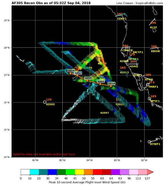
4Sept18 1aCDT/2aEDT: Winds 65mph(100km/h), moving WNW 17mph(28km/h), pressure 1004mb. Air Force reconnaissance plane flying through the storm found slightly higher winds but overall an unchanged system from a few hours ago.
Gordon is a sheared system. There's virtually nothing on the SW half of it...like if you took and cut across it at a 45-degree angle from top left corner to bottom right corner and kept the top right part of it, even part of the top/top left corner is missing compared to a traditional well built storm. Banding pretty much all on the East side of the storm center that's more indicative of a sub-tropical system. Aircraft recon currently flying in/around storm measuring a small pocket of winds near 50/60mph near the storm center and a large area with all the showers in the 30-45mph range but the left side that's missing winds only in the 10-20mph range.
So it may not look like a traditional tropical system but it still has a kick to it with plenty of features/events/hazards you'd expect from a tropical system.
Infrared imagery:
Microwave imagery shows more of a squally blob then a tropical system:
Gordon is a sheared system. There's virtually nothing on the SW half of it...like if you took and cut across it at a 45-degree angle from top left corner to bottom right corner and kept the top right part of it, even part of the top/top left corner is missing compared to a traditional well built storm. Banding pretty much all on the East side of the storm center that's more indicative of a sub-tropical system. Aircraft recon currently flying in/around storm measuring a small pocket of winds near 50/60mph near the storm center and a large area with all the showers in the 30-45mph range but the left side that's missing winds only in the 10-20mph range.
So it may not look like a traditional tropical system but it still has a kick to it with plenty of features/events/hazards you'd expect from a tropical system.
Microwave imagery shows more of a squally blob then a tropical system: Attachment 202013
Out flow does not look good or the exhaust. Loop sided system at best and forward speed is too fast for it to get real strong. Not enough time nor upper level support.
4Sept18 7aCDT/8aEDT: Winds 65mph(100km/h), moving WNW 15mph(25km/h), pressure 1004mb. No changes from 4a/5a post above.
Rain shield and windy conditions pushing into portions of the N Gulf coast now. Tornado threat will increase as these move onshore throughout the day and into tonight.
Just adding a quick note on surge: last night maps indicated St. Louis Bay may have some of the higher surge, now peak could be a little more to the East...Gulfport, MS general area. Surge will still effect a wide swath though.
Storms firing up around the storm center once again as it tries it hand at intensifying before landfall, pressure falling (= strengthening), and lightning around core (= probable intensity change occuring).
Changes:
-Tropical Storm Warning discontinued West of Grand Isle, LA.
Tropical Storm force winds extend up to 80miles from storm center, almost exclusively on the East and North side. Rain, flood threat, tornado threat, and rising surge will increase into the afternoon. Conditions will quickly deteriorate as these rain bands come inland.
And a reminder that in the US on average over 75% of deaths in tropical systems come from surge & inland flooding.
Last edited by Psychoma; 09-04-2018 at 09:03 AM..
Please register to post and access all features of our very popular forum. It is free and quick. Over $68,000 in prizes has already been given out to active posters on our forum. Additional giveaways are planned.
Detailed information about all U.S. cities, counties, and zip codes on our site: City-data.com.

 Please register to participate in our discussions with 2 million other members - it's free and quick! Some forums can only be seen by registered members. After you create your account, you'll be able to customize options and access all our 15,000 new posts/day with fewer ads.