Welcome to City-Data.com Forum!
U.S. CitiesCity-Data Forum Index
Go Back   City-Data Forum > General Forums > Weather > Hurricanes
 [Register]
Please register to participate in our discussions with 2 million other members - it's free and quick! Some forums can only be seen by registered members. After you create your account, you'll be able to customize options and access all our 15,000 new posts/day with fewer ads.
View detailed profile (Advanced) or search
site with Google Custom Search

Search Forums  (Advanced)
Reply Start New Thread
 
Old 10-09-2018, 12:22 AM
 
Location: The canyon (with my pistols and knife)
14,186 posts, read 22,747,384 times
Reputation: 17398

Advertisements

Quote:
Originally Posted by BullochResident View Post
I'm right in the bulls eye of that rain. For some reason, though, I'm doubtful it'll be that much because the storm is expected to pick up speed as it moves inland across Georgia.
I'm just glad that it'll likely be passing to my southeast. That'll put me on the "good" side of the storm, so I'll probably just get an inch or two of rain from Wednesday night through Thursday afternoon, and tropical-depression-force winds. It'll feel nice after the relentless 90s from mid-May to last week. If this is what it takes to put a merciful end to this **** for the year, then so be it. Bring it on.

The last thing I wanted was another Opal, which came screaming on shore at a high rate of speed and passed west of Atlanta, putting me on the "bad" side of the storm with strong tropical-storm-force winds. My family moved into a brand-new house that summer, and we had to refasten some of the vinyl siding and roof shingles that blew off. Listening to the big trees splintering during the strongest wind gusts freaked me out too.
Reply With Quote Quick reply to this message

 
Old 10-09-2018, 04:05 AM
 
30,432 posts, read 21,255,233 times
Reputation: 11984
Another miss for me. Just unreal i can't even get a tropical system.
Reply With Quote Quick reply to this message
 
Old 10-09-2018, 04:13 AM
 
Location: In Miami but, Inside the Resistance !!
1,790 posts, read 1,414,037 times
Reputation: 981
Quote:
Originally Posted by LKJ1988 View Post
Another miss for me. Just unreal i can't even get a tropical system.
You're goinn to get lots of rain, and that is what you have been praying for since I joined this place.

Don't WORRY, be Happy !!!!
Reply With Quote Quick reply to this message
 
Old 10-09-2018, 04:22 AM
 
7,259 posts, read 4,629,838 times
Reputation: 2105
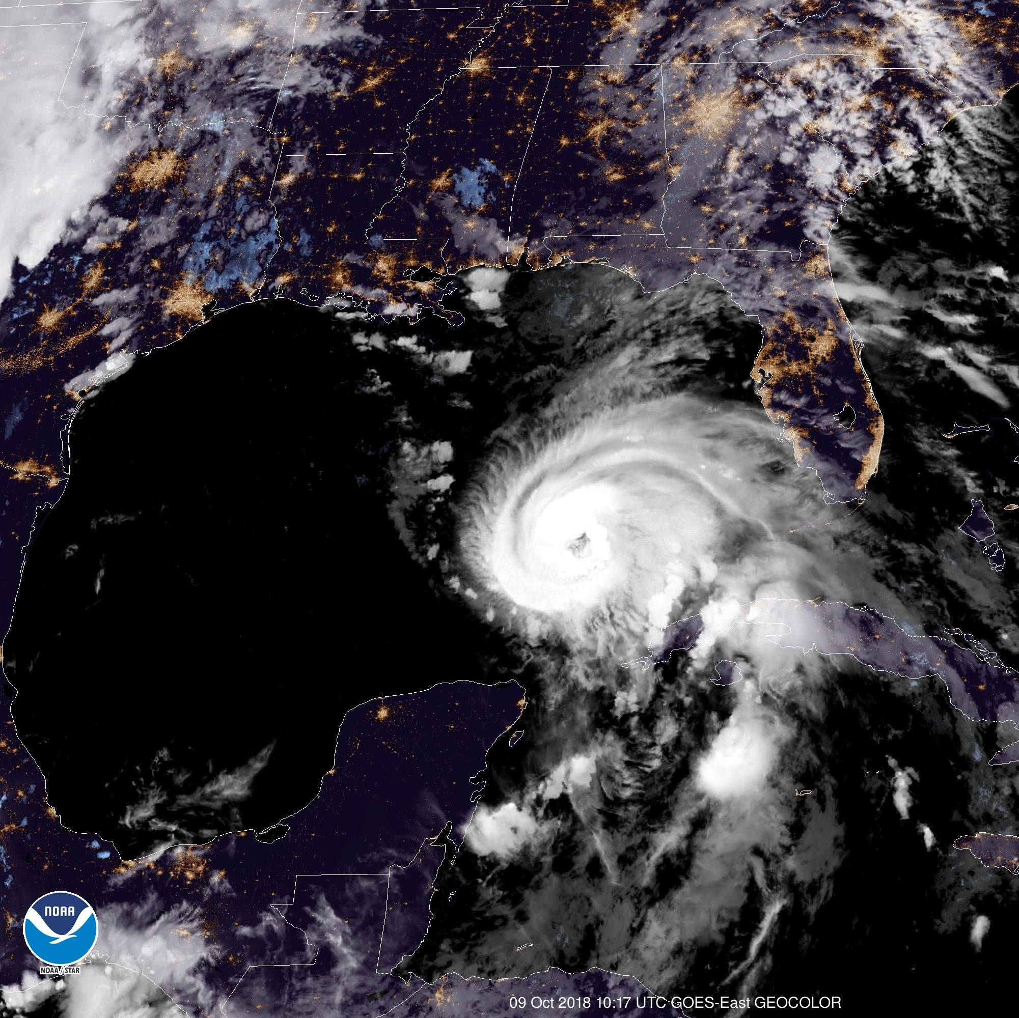
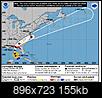
9Oct18 4aCDT/5aEDT - Winds 90mph(150km/h), moving NNW 12mph(19km/h), pressure 973mb.

Current Watches/Warnings:
-Storm Surge Warning (life-threatening danger of surge within 36hours or less, waters start rising hours before storm center arrives and can cut off escape routes early on, leave if told to do so) Okaloosa/Walkton line FL to Anclote River FL
-Storm Surge Watch Anclote River FL to Anna Maria Island FL, including Tampa Bay & AL/FL border to Okaloosa/Walton County Line FL
-Hurricane Warning AL/FL border to Suwannee River Fl
-Hurricane Watch AL/FL border to the MS/AL border
-Tropical Storm Warning AL/FL border to the MS/AL border; Suwanee River FL to Chassahowitzka FL; The Cuban province of Pinar del Rio
-Tropical Storm Watch Chassahowitzka, FL to Anna Maria Island FL, including Tampa Bay; MS/AL border to the Mouth of the Pearl River; Fernandina Beach, FL to South Santee River, SC.

Interactive storm surge map (worst case scenario that could happen given current storm forecast that should be planned to, but hope for less): https://www.nhc.noaa.gov/refresh/gra...ation#contents


Landfall expected Wednesday. Continued strengthening likely until landfall. Hurricane force winds (74+mph) currently extend up to 40miles from storm center, Tropical Storm force winds (39-73mph) extend up to 195miles.

Rains:
Cuba: 4-8inches, isolated 12inches
FL Panhandle / Big Bend, SE AL, S GA: 4-8in, isolated 12in.
E GA, NC, SC, and S VA: 3-6in.
Other areas of FL, mid Atlantic states near the coast and S New England potentially 1-3in depending on track.

Tornadoes: Will likely start seeing across portions of FL Panhandle, N FL, and S GA late tonight into Wednesday, mainly as rain bands come in.

At least it'll move fast once ashore.
Atlantic - Michael forms October 7, 2018-15s.jpg
Reply With Quote Quick reply to this message
 
Old 10-09-2018, 04:24 AM
 
30,432 posts, read 21,255,233 times
Reputation: 11984
Quote:
Originally Posted by Hammocks Bum View Post
You're goinn to get lots of rain, and that is what you have been praying for since I joined this place.

Don't WORRY, be Happy !!!!
I am not gonna get anything. At most under .25" unless it tracks a 100 miles more to the east. Wanna make a bet on the rain?
Reply With Quote Quick reply to this message
 
Old 10-09-2018, 04:27 AM
 
7,259 posts, read 4,629,838 times
Reputation: 2105
Eye has formed:
Atlantic - Michael forms October 7, 2018-img_4153.jpg
Reply With Quote Quick reply to this message
 
Old 10-09-2018, 04:29 AM
 
Location: Near the Coast SWCT
83,518 posts, read 75,307,397 times
Reputation: 16619
Quote:
Originally Posted by Psychoma View Post
Eye has formed and getting that classic hurricane shape:
Whoa! Nice! Let me grab a loop.

P.S .. You're going to run out of CityData attachment space. I'd hate for you to start deleting photos to make room for new ones on C-D. All the previous threads will have missing photos in your posts. Have you considered using another hosting site like Imgur? Its very easy to use and free.
Reply With Quote Quick reply to this message
 
Old 10-09-2018, 04:31 AM
 
7,259 posts, read 4,629,838 times
Reputation: 2105
Ya, I've been thinking about where to store them, I'm around 75+% of my allotted space and climbing fast with these higher res sat images.
Reply With Quote Quick reply to this message
 
Old 10-09-2018, 04:38 AM
 
Location: Near the Coast SWCT
83,518 posts, read 75,307,397 times
Reputation: 16619
Infrared Loop last 4hrs of Hurricane Michael.

From 4am Update:
MAXIMUM SUSTAINED WINDS 90 MPH
NNW OR 345 DEGREES AT 12 MPH
MINIMUM CENTRAL PRESSURE...973 MB
Hurricane-force winds extend out 40 miles from the
center
Tropical-storm-force winds extend to 195 miles


Reply With Quote Quick reply to this message
 
Old 10-09-2018, 04:47 AM
 
Location: the sticks
935 posts, read 1,649,412 times
Reputation: 646
sure appreciate these threads, you all do great work. TWC is nothing but Hollywood wannabes and I'm grateful for the knowledge and updates. I'm in SC two hours inland and have learned to rely on CD/weather/hurricane/psycoma cambium and more!
Reply With Quote Quick reply to this message
Please register to post and access all features of our very popular forum. It is free and quick. Over $68,000 in prizes has already been given out to active posters on our forum. Additional giveaways are planned.

Detailed information about all U.S. cities, counties, and zip codes on our site: City-data.com.


Reply
Please update this thread with any new information or opinions. This open thread is still read by thousands of people, so we encourage all additional points of view.

Quick Reply
Message:


Over $104,000 in prizes was already given out to active posters on our forum and additional giveaways are planned!

Go Back   City-Data Forum > General Forums > Weather > Hurricanes

All times are GMT -6. The time now is 07:07 AM.

© 2005-2024, Advameg, Inc. · Please obey Forum Rules · Terms of Use and Privacy Policy · Bug Bounty

City-Data.com - Contact Us - Archive 1, 2, 3, 4, 5, 6, 7, 8, 9, 10, 11, 12, 13, 14, 15, 16, 17, 18, 19, 20, 21, 22, 23, 24, 25, 26, 27, 28, 29, 30, 31, 32, 33, 34, 35, 36, 37 - Top