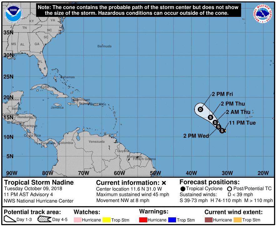
9Oct18 11aEDT/AST: On Tuesday morning Tropical Depression 15 formed and by 11am has become Tropical Storm Nadine in the far Eastern Atlantic off W Africa.
11pEDT/AST: Estimated winds 45mph(75km/h), moving NW 8mph(13km/h), pressure 1003mb.
Expected to strengthen some over the next day or so then gradually weaken as interacts with a trough, increasing shear, and eventually cooler waters. Official NHC forecast has it dissipating this weekend but has it getting to a strong Tropical Storm prior to then. There is some disagreement in models on track in a few days. Will watch for what it does in a few days.

Official updates for Atlantic basin storms comes from the US National Hurricane Center based in Miami, FL. Updates are issued at 5 & 11am/pmEDT/AST (If Watches/Warnings issued then updates are also added at 2 & 8am/pmEDT/AST) here:
https://www.nhc.noaa.gov
Cone map (Shows: Current storm wind field at storm center(orange: winds 39mph+, red: 74mph+), Classification (Black/white dots with letters: "D" = Depression, "S" = Tropical Storm, "H" = Cat1 or Cat2 Hurricane, "M" = Major Hurricane (Cat3+)), any coastal tropical Watches/Warnings, and the "cone" is where the center of the storm could be over time (it's NOT the size of the storm), effects of the storm can be felt outside this area:
Some Satellite imagery sources:
-Tropical Tidbits:
https://www.tropicaltidbits.com/sat/
-GOESeast(GOES16):
https://www.star.nesdis.noaa.gov/GOES/index.php )
-WeatherNerds (includes ASCAT overlay option when available):
https://www.weathernerds.org/satellite/floaters/
 Please register to participate in our discussions with 2 million other members - it's free and quick! Some forums can only be seen by registered members. After you create your account, you'll be able to customize options and access all our 15,000 new posts/day with fewer ads.