Please register to participate in our discussions with 2 million other members - it's free and quick! Some forums can only be seen by registered members. After you create your account, you'll be able to customize options and access all our 15,000 new posts/day with fewer ads.
NOAA released their predictions for the season this week. These will be revised in August just before peak season arrives. Just general guidance, doesn’t really mean much. Really just highlights if conditions are overall more or less favorable given similar conditions of years past. No way to know if something will effect land or not.
Only area being monitored for possible storm development currently is either side of Central America but nothing really standing out yet. Enjoy your extended holiday weekend.
Atlantic (Atlantic, Gulf of Mexico, Caribbean):
-Likely near normal season
-9 to 15 named storms
-4 to 8 hurricanes
-2 to 4 Cat3+ hurricanes
E Pacific:
-70% chance of above normal season
-15 to 22 named storms
-8 to 13 hurricanes
-4 to 8 Cat3+ hurricanes
Central Pacific:
-70% chance of above normal season
-5 to 8 cyclones between depression & hurricane
Hey guys I’m TJ! I’m new to this forum site but I wanted to branch out more and discuss meteorological topics with more people. I would really like if you guys could possibly check out an article I wrote about some potential tropical development and maybe give me some feedback too!
Hey guys I’m TJ! I’m new to this forum site but I wanted to branch out more and discuss meteorological topics with more people. I would really like if you guys could possibly check out an article I wrote about some potential tropical development and maybe give me some feedback too!
Hey TJ, and welcome to the CD Hurricane board! I find I love info/data especially on hurricanes so additional input/voices are always welcome! The board here is pretty inactive in the off season but when a storm arises can become quite busy.
You asked for feedback so my own half a cent input would just be: Your article has the MJO passage and CAG info (with research from Philippe Papin who’s studied CAGs) which as you mention may be a catalyst so good science & understanding behind the possibility. Maybe include the mention of MJO in the article text instead of just inside an imbedded tweet. And the word “Note:” just seemed to seperate the closeing paragraph from article, could just be the way website loaded on cell phone too. But you know your audience better than me.
I personally find models have a hard time predicting tropical genesis from CAGs more then a couple days out and tend to spin up hints of ghost storms but one does form every now and then. NHC still keeping 30-40% chance of development on the Pacific side near Nicaragua. If the Atlantic side sees any consistent convection wouldn’t be surprised to see them put out a Low chance region, but nothing as of yet.
Here’s a tweet/thread that go’s along with your article with some additional reasoning from Tropical Tidbits. Although I can follow what they’re saying, being a fan and not a meteorologist, I may not always fully understand the underlying science behind it but I try to learn a little more each year:
Wow thank you for the amazing feedback, I’m definitely taking what you said into consideration for future articles! I also saw that thread that Levi Cowan posted actually yesterday. Definitely Helped to clear a few questions I had. Do you have a Twitter account? I’d sure love to follow ya!
For those that follow along from Hawaii: On Saturday June 1, 2019 (also the start date of the Central Pacific Hurricane Season) the Hurricane Hunter G-IV aircraft NOAA49 “Gonzo” (the one that looks like a modified private jet) will be available to tour at Castle & Cooke Aviation at 155 Kapalulu Place, adjacent to the Daniel K. Inouye International Airport in Honolulu from 10a-2p local time, free admission & parking. Meet the flight crew, NWS & Hurricane forecasters & other educational info/activities on hand. The G-IV doesn’t fly through hurricane storm centers like its bigger brother & sister P3 Orion aircraft but does fly important missions collecting data around and in front of hurricanes for better modeling data input and insight into what a storm may do next.
31May2019 2pEDT/1pCDT:
Atlantic:
Models have quickly jumped onto a system trying to form in the Bay of Campeche (SW Gulf of Mexico) late this weekend into early next week. This is likely from the earlier CAG (Central American Gyre, which can help spit out Tropical systems occasionally on the Atlantic or Pacific sides) moving up that direction and the shape of the land in that area can help facilitate winds that encourage a spin on a Low Pressure trying to form. Currently the area being watched is a disorganized very small blob heading generally Westward over the Yucatán Peninsula. Models seem to indicate it may come into the Mexico coast or near the coast as turns more NW / N early next week and subsequent moisture into SE / E Texas, with a few models wanting to keep it more near the coast and head towards Texas / Louisiana region by mid to late next week. Regardless of any development, Tropical moisture may spread into these regions at some point next week. Water temps across the entire Gulf of Mexico are warm enough to support tropical development. Wind shear is currently high across the Northern coast of the Gulf of Mexico which would limit or weaken anything that tries to move up that way though, but I did not look at wind shear models for next week yet to see if shear changes or not. The NHC is currently giving this small blob a low 20-30% chance of development.
For climatology reference, per Philip Klotzbach, the earliest Hurricane (winds 74+mph) to ever hit the US mainland was “Alma” on June 9, 1966. (Tropical Storms have earlier though).
1Jun19 2pEDT/1pCDT: First official day of the 2019 Atlantic & Central Pacific Hurricane seasons.
Atlantic:
The disturbance mentioned in last post has been designated as Invest 91L, just a number assigned for tracking purposes...it's still just a blob of disorganized showers. NHC now giving it a medium 60% chance of development. Storm details haven't changed since yesterday otherwise. Tropical Tidbits has posted a video discussing the scenarios ahead for this system, please give it a look here: https://youtu.be/c6zwPOwDshU
Some of the possible tropical moisture into E Texas and Louisiana that may be forced up starting to show up in the NOAA 7-day possible rain totals. These values may go up as we start the week depending what the system does.
2Jun19 2pEDT/1pCDT:
Atlantic: invest 91L in Bay of Campeche (SW Gulf of Mexico) visually has a nice general spin to it today but IR & Water Vapor imagery show lack of organized convection so remains a blob of disorganized showers. Hurricane Hunter reconnaissance aircraft originally scheduled to check it out today has been postponed until Monday now. A reminder: potential areas being watched for development, including 91L, are updated by the National Hurricane Center (NHC) 4 times a day, every 6hours (or as needed if something suddenly changed), at or just before 2 & 8am/pmEDT (1 & 7a/pCDT) here: https://www.nhc.noaa.gov/gtwo.php?basin=atlc&fdays=5
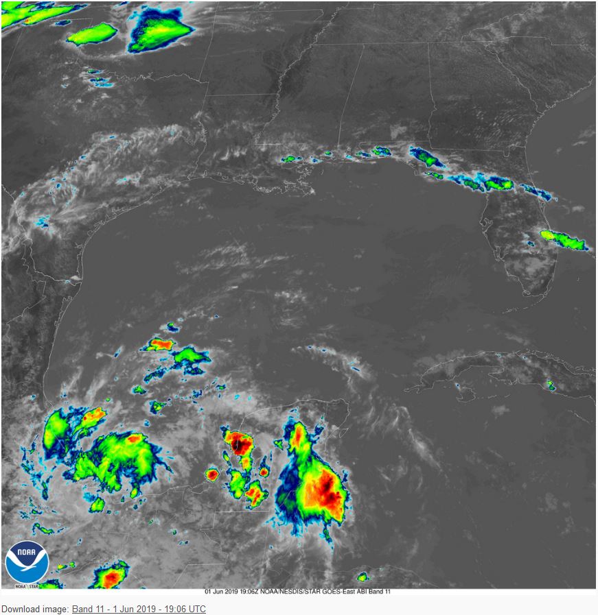
And satellite imagery of the Gulf of Mexico updated every 5 minutes, courtesy GOES-East (GOES16)...love tech these days...used to be 15 to 30 min between images just a couple years ago!), updated here (times in “UTC” or Zulu time which is 4-hours ahead of EDT or 5hours CDT, so 18:00 UTC means pic taken at 6p UTC = 2p EDT / 1pCDT): https://www.star.nesdis.noaa.gov/GOE...=G16§or=gm
3Jun19 8pEDT/7pCDT Monday:
Atlantic: Invest 91L in Bay of Campeche (SW Gulf of Mexico) (again just a blob of disorganized scattered showers) is running out of time to develop. Hurricane Hunter recon aircraft was again canceled today. They'll try again tomorrow if it looks better organized. Regardless of development, scattered showers are likely to start being funneled up into parts of SE/E Texas and Louisiana by Wednesday. These may be scattered but where they do fall could be heavy. See your local NWS or local news for additional details. Tropical moisture is likely to help feed additional moisture up into the Midwest and eventually spread eastward across portions of the US as well. High wind shear is present across the entire Northern Gulf of Mexico. Higher wind shear can tear tropical systems apart. I like to never say never, so yes there's still a chance it eeks out a name but the main focus will & should remain on the upcoming rains.
Please register to post and access all features of our very popular forum. It is free and quick. Over $68,000 in prizes has already been given out to active posters on our forum. Additional giveaways are planned.
Detailed information about all U.S. cities, counties, and zip codes on our site: City-data.com.

 Please register to participate in our discussions with 2 million other members - it's free and quick! Some forums can only be seen by registered members. After you create your account, you'll be able to customize options and access all our 15,000 new posts/day with fewer ads.