Please register to participate in our discussions with 2 million other members - it's free and quick! Some forums can only be seen by registered members. After you create your account, you'll be able to customize options and access all our 15,000 new posts/day with fewer ads.
26Jun19 11aEDT/8aPDT: On Tuesday 25Jun Invest 93E became Tropical Depression One-E. On Wednesday 26Jun system has organized enough to become Tropical Storm Alvin, the first named storm of the 2019 East Pacific Hurricane season. This is the third latest first named storm formation on record since 1966 (Satellite era) in the EPAC, only behind 1969 & 2016 seasons with first named storm forming July 2.
Winds 40mph(65km/h), moving W 14mph(22km/h), pressure 1005mb. Heading away from land. May brush Clarion Island with showers/breeze. Expected to strengthen some over the next 24 hours or so then begin weakening as encounters higher wind shear, cooler waters and drier air. May dissipate by this weekend. The track was shifted a little more South to be more in line with the Euro model today as Tuesday the Euro was considered an outlier S of all the other models but today it won.
Official updates are released by the US National Hurricane Center every 6 hours at 5 & 11am/pmEDT (2 & 8am/pmPDT) here: https://www.nhc.noaa.gov/?epac
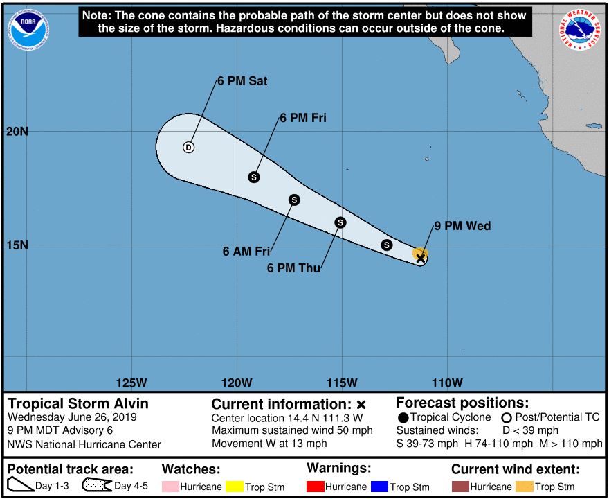
26Jun19 11pEDT/8pPDT: Winds 50mph(85km/h), moving W 13mph(20km/h), pressure 1001mb. Located about 595miles(955km) South of S tip of Baja. Has a good 24 hours to continue intensifying then falls apart by the weekend.
27Jun19 morning update: the 5aEDT/2aPDT NHC advisory bumped up the estimated winds to 60mph, pressure 999mb, and it doesn’t look like its changed much since then. But recent microwave imagery shows a VERY tiny core which can allow a tropical system to very rapidly change wind speed up or down so sudden changes are possible next 12-24hours FYI. Still heading away from land, still falls apart this weekend, very small physical size storm now including its cloud cover.
27Jun19 11pEDT/8pPDT: Estimated winds 75mph(120km/h), moving NW 16mph(26km/h), pressure 992mb. Cat1 hurricane. Located about 520miles(840km) South of S tip of Baja, heading away from land. Very small storm. As was mentioned earlier the very tiny core was noticed on microwave imagery and through this evening with a short time of an eye trying to clear out on visible satellite at one point but never fully materialized. Estimated hurricane force winds only go out about 10 miles(20km) from the center, Tropical Storm winds 45miles(75km). Small storms are prone to sudden changes up or down in wind speed but either way by Friday evening will be reaching the end of the line and falls apart quickly this weekend.
28Jun19 11aEDT/8aPDT: Estimated winds 65mph(100km/h), moving NW 15mph(24km/h), pressure 999mb. Drier air, increasing wind shear, and cooler waters visibly taking a toll on Tropical Storm Alvin. Un-recoverable at this point. It’s on its way out.
29Jun19 11aEDT/8aPDT: and Alvin is no more. Just a swirl of a remnant Low pressure. An archive of all previous official advisories from the US NHC can be found here: https://www.nhc.noaa.gov/archive/2019/ALVIN.shtml?
Please register to post and access all features of our very popular forum. It is free and quick. Over $68,000 in prizes has already been given out to active posters on our forum. Additional giveaways are planned.
Detailed information about all U.S. cities, counties, and zip codes on our site: City-data.com.

 Please register to participate in our discussions with 2 million other members - it's free and quick! Some forums can only be seen by registered members. After you create your account, you'll be able to customize options and access all our 15,000 new posts/day with fewer ads.