Please register to participate in our discussions with 2 million other members - it's free and quick! Some forums can only be seen by registered members. After you create your account, you'll be able to customize options and access all our 15,000 new posts/day with fewer ads.
The more damage in a less developed country/area, the more difficult to return to normal—
Did you consider that?
Most of those people are living below poverty line
Infrastructure gone can be devastating for months vs days or weeks as in areas w/better resources
Just to GET to the Bahamas w/relief supplies will take time and effort that wouldn’t be required if it were driveable from the state next door...
I can’t imagine how terrible that noise and pressure must have been for people that were not someplace with very thick concrete walls—
PTSD can be an after effect of something like this for long time...
What happened in the Bahamas was horrible, but I guess the silver lining was that the areas impacted were of relatively low population. If Dorian had stalled like it did near Florida, or slammed into Florida as the slow moving Category 5 it was, the impacts would have been much, much worse as Florida is a much more densely populated area. Yes, Florida can recover faster and more easily than the Bahamas, but A LOT more people are affected. Also, Dorian has stayed far enough off shore to spare the Southeastern Seaboard states the worst of the impacts. They're still taking a hit but the worst of the hurricane is staying offshore.
Dorian is a bad hurricane. Definitely worthy of retirement. But it could have been so much worse. It was the strongest landfalling hurricane in history. Most Category 5 hurricanes cause hundreds (or even thousands) of deaths and have at least $10 billion in damage. I'm guessing (and certainly hoping) that Dorian's death toll falls below 100.
All things considered, I'd say Dorian, in terms of overall damage and impact, is about on the level of Hurricane Michael last year.
Heard from my relative on St Simons around noon today - no serious issues there. Around 95% of the residents evacuated and most businesses shut down, but were reopening.
Big sigh of relief for my relative - but so sad for others' terrible losses.
Thurs 1155p radar & wind velocity image. The colored wind image on right is radar interpretation of wind speeds...basically the brighter colors around the eye (Orange/deep blues) are the highest winds which are just barely ( or not ) touching the coast near Wilmington, NC currently. Outside this zone is less, near it likely near hurricane force or less and further less as you get away from the eye although in heavier rain bands the winds can pick up some. We’ll see if this comes onshore more or not by Friday, otherwise most locations just Tropical Storm winds, only a few have recorded hurricane force (74mph+) so only a few areas have experienced a hurricane today, rest a Tropical Storm (saying that so if another ever comes you can’t say I made it through a Cat2/3, no you didn’t). And that colored wind ring around eye doesn’t look complete because wind direction is relative to the radar tower so it can only color based on if wind heading away or towards radar so that’s why there’s a gap between orange/peach and blues that surround the calm/clear eye.
5a Friday - Winds 90mph, moving NE 14mph, pressure 956mb. Storm Surge Warnings South of Surf City, NC all canceled (so Wilmington, NC and southward no surge higher than 3ft anymore). Hurricane force winds extend up to 45miles from center.
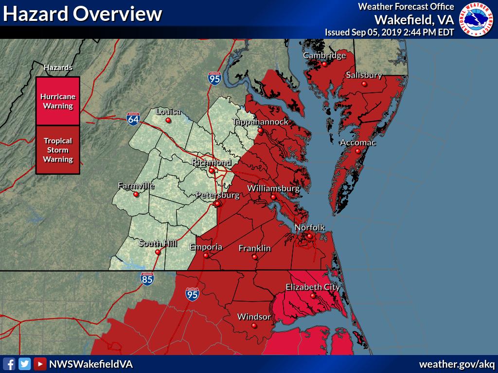
Expected wind gusts:
75-85 MPH for immediate coast of Northeast NC
65-75 MPH along VA Beach coast
55-65 MPH Hampton Roads
50-60 MPH Lower Eastern Shore
35-45 MPH I-95 Corridor (Richmond)
Please register to post and access all features of our very popular forum. It is free and quick. Over $68,000 in prizes has already been given out to active posters on our forum. Additional giveaways are planned.
Detailed information about all U.S. cities, counties, and zip codes on our site: City-data.com.

 Please register to participate in our discussions with 2 million other members - it's free and quick! Some forums can only be seen by registered members. After you create your account, you'll be able to customize options and access all our 15,000 new posts/day with fewer ads.