Please register to participate in our discussions with 2 million other members - it's free and quick! Some forums can only be seen by registered members. After you create your account, you'll be able to customize options and access all our 15,000 new posts/day with fewer ads.
With it currently forecast to hit between Houston and New Orleans..it looks like that would send the brunt of the winds and surge into the fairly thinly settled coastal areas of Western LA. Seems like that's where you'd want it to come in to avoid the worst issues for the Houston or NOLA areas.
Ya much more rural considering the alternatives. Still very flat....that surge can go an awfully long ways inland...
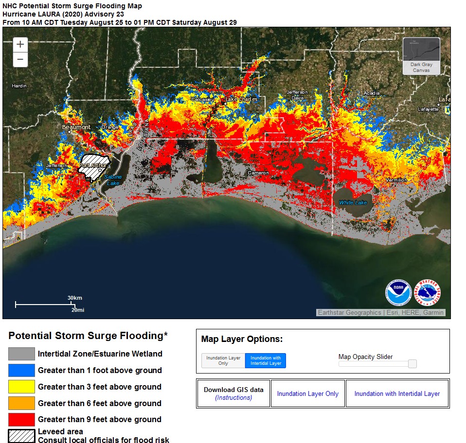
(This is the 11aEDT/10aCDT potential surge map that has a 1 in ten chance of being exceeded. So plan to and hope for less map, final track will determine final heights but will be high across a huge swath.)
Tue 2pEDT/1pCDT
Winds 75mph(120km)
Moving WNW 16mph(26km/h)
Pressure 990mb
Center about 525miles(845km) SE of Lake Charles, LA
Center about 560miles(900km) SE of Galveston, TX
NHC’s 2p update reveals no new changes. Storm still organizing itself.
Since this is a factor for those evacuating and for recovery after the storm, here’s the cone map overlaid onto COVID 7day averaged per capita of new cases map: https://twitter.com/burgwx/status/1298292876443557894
And Levi of Tropical Tidbits mentioning the larger size results in slower intensification but sets it up to be healthier for later and may see increase in the strengthening by tomorrow. https://twitter.com/tropicaltidbits/...97845695610882
Tue 5pEDT/4pCDT
Winds 80mph(130km)
Moving WNW 17mph(28km/h)
Pressure 990mb
Center about 480miles(770km) SE of Lake Charles, LA
Center about 510miles(820km) SE of Galveston, TX
Hurricane winds extend up to 45miles(75km) from center, TS winds 175miles(280km)
No changes. Just slight bump up in winds as center continues to better organize. Expected to intensify & Landfall Wednesday night / early Thurs. NHC states to remember that the average error in track of storm 36hours out is around 60miles, don't focus on an exact point, shifts are possible and wide reaching impacts. Average 36hour error in intensity forecast is 10mph.
With flat land and lots of water ways, on surge NHC mentions “This storm surge could penetrate up to 30 miles inland from the immediate coastline in southwestern Louisiana and far southeastern Texas.”
Interactive map showing coastal and inland threats wind, storm surge, tornado and rain.
Click “threats and impacts” tab this page, then select the radio button/circles to cycle through different maps: https://www.weather.gov/srh/tropical
Please register to post and access all features of our very popular forum. It is free and quick. Over $68,000 in prizes has already been given out to active posters on our forum. Additional giveaways are planned.
Detailed information about all U.S. cities, counties, and zip codes on our site: City-data.com.

 Please register to participate in our discussions with 2 million other members - it's free and quick! Some forums can only be seen by registered members. After you create your account, you'll be able to customize options and access all our 15,000 new posts/day with fewer ads.