Please register to participate in our discussions with 2 million other members - it's free and quick! Some forums can only be seen by registered members. After you create your account, you'll be able to customize options and access all our 15,000 new posts/day with fewer ads.
28Aug18 5pHST/8pPDT/11pEDT: Tropical Depression 16E has organized enough to become Tropical Storm Norman off the West Mexico coast, west of Socorro Island. Estimated winds 50mph(85km/h), moving WNW 10mph(17km/h), pressure 1000mb. Located about 455miles(730km) SW of S Tip of Baja.
Warm waters and low shear = likely to quickly strengthen. NHC notes rapid intensification is highly probable as it continues to move away from the Mexico coast. Hawaii should keep an eye on this one as it crosses the Pacific...track would definitely get it near the islands in time, question is how close.
Intensity guidance models:
Official updates for Eastern North Pacific basin storms comes from the US National Hurricane Center based in Miami, FL. Updates are issued at 2 & 8am/pmPDT (5 & 11am/pmHST/EDT) (If Watches/Warnings issued then updates are also added at 5 & 11am/pmPDT(2 & 8am/pmHST/EDT)) here: https://www.nhc.noaa.gov/?epac
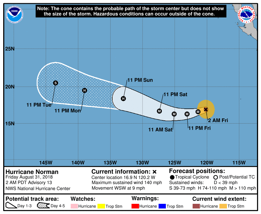
Cone map (Shows: Current storm wind field at storm center(orange: winds 39mph+, red: 74mph+), Classification (Black/white dots with letters: "D" = Depression, "S" = Tropical Storm, "H" = Cat1 or Cat2 Hurricane, "M" = Major Hurricane (Cat3+)), any coastal tropical Watches/Warnings, and the "cone" is where the center of the storm could be over time (it's NOT the size of the storm), effects of the storm can be felt outside this area):
Satellite imagery Links (and a random sample from each):
-GOES 16 (GOESeast) until it gets too far West (Out newest operational weather satellite): https://www.star.nesdis.noaa.gov/GOES/index.php
-GOESwest (New "GOES17" JUST came into 'non-operational' access!! We're in! Limited imagery but it's coming out finally! And after suffering a cooling failure which knocked most of its channels offline it's been brought back to some degree...some imagery will be limited based on temps): https://weather.msfc.nasa.gov/cgi-bi...roduct=11p20um
30Aug18 2aPDT/5aEDT - Estimated winds 115mph(185km/h), moving W 7mph(11km/h), pressure 964mb. There's the rapid intensification...now just enough for a Cat3.
Models in fairly tight agreement on track, although effects on Hawaii cannot be ruled out, model guidance suggest the storm will go just North of Hawaii next week. But will watch to make sure that doesn't change.
30Aug18 5aPDT/8aEDT - Rapid intensification continues and a special advisory was issued to update storm stats: Estimated winds 145mph(230km/h), moving W 8mph(13km/h), pressure 942mb. Strong Cat4 now.
31Aug18 2aPDT/5aEDT Estimated winds 140mph(220km/h), moving WSW 9mph(15km/h), pressure 946mb. Looks like Norman peaked at around 150mph after rapid intensification. Majority of models still take a weaker storm North of Hawaii but should keep an eye on it in case something were to change.
3Sept18 2aPDT/5aEDT (2Sept18 11pHST) Estimated winds 125mph(205km/h), moving WNW 20mph(31km/h), pressure 955mb. Weakening once more after it ramped back up again. Strong Cat3 currently. Generally steady weakening overall expected from here on out. Located about 1,335miles(2,150km) E of Hilo, HI. Hurricane force winds extend out only 35miles(55km from storm center).
Will cross 140W into the Central Pacific soon, which would transfer responsibility from the NHC to the CPHC. Overall guidance supports storm not affecting Hawaii, but I would still keep an eye on it to make sure the track doesn't shift a little more westward.
4Sept18 5pHST/8pPDT/11pEDT - Estimated winds 80mph(130km/h), moving W 12mph(19km/h), pressure 984mb. Large swells expected to reach Hawaii Tuesday evening through the week. NOAA Hurricane Hunter Gulfstream aircraft NOAA9 ("Gonzo") has been out taking measurements around the region for better modeling data.
Probability map of seeing Tropical Storm force winds (39+mph):
5Sept18 5pHST/8pPDT/11pEDT - Norman with a last minute burst of energy there. Estimated winds 120mph(195km/h), moving WNW 9mph(15km/h), pressure 960mb.
Please register to post and access all features of our very popular forum. It is free and quick. Over $68,000 in prizes has already been given out to active posters on our forum. Additional giveaways are planned.
Detailed information about all U.S. cities, counties, and zip codes on our site: City-data.com.

 Please register to participate in our discussions with 2 million other members - it's free and quick! Some forums can only be seen by registered members. After you create your account, you'll be able to customize options and access all our 15,000 new posts/day with fewer ads.