Please register to participate in our discussions with 2 million other members - it's free and quick! Some forums can only be seen by registered members. After you create your account, you'll be able to customize options and access all our 15,000 new posts/day with fewer ads.
Wow, I wouldn't even know where to start!!! A lot has changed over the past couple of years, or just in the years I've been around. Mcclain has obviously renovated the bowling alley and movie theater. The bus area was moved to Truman road. The Community Service League moved to Noland Road, and is currently vacant, however that building will house Jackson County employees in the future. The historic courthouse is also being renovated, and will once again house Jackson County employees as well. The current courthouse will only be used for courts.
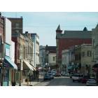
There have been a few businesses open and close recently. The Sunshine Center is currently vacant. The fudge place has closed, and is now another business. Gregory G’s BBQ, which started around 2008 closed. The Main Street Coffee house is still open, but under new ownership.
There are quite a few new eating places. On Maple, next to Big John’s Bar is a place called UpDog, which neighbors another new place, Yogurtini. Yogurtini is the only franchise on the square, as they are starting to turn up everywhere, including one opening in the Independence Center soon. Updog is a hot dog place – they serve various sizes of hot dogs and sides.
Other eating places still include Café Verona, Dave’s Deli, Courthouse Exchange, The Rheinland (German Food), O’Phelia’s, Clinton’s, Square Pizza (also newer, as of a few years ago) and even Diamond Bowl, which serves food. There is a taffy store called Just Taffy that’s been around for a few years, and their taffy is amazing! They also serve snacks and fudge.
For leisure nowadays, the movie theater and bowling alley are two of the more populated places on the square in the evenings. There is also a place called “Game Café” on Lexington, which hosts all sorts of games to be played and has games for sale, etc.
I’d like to do a full run-down of the square sometime… What do many of you consider to be the square? What streets? Main, Osage, Liberty, Lexington, Maple, Kansas? Obviously not the entire street, but you know what I mean… Just curious what many of you would consider officially to be “the square”.
I take all kinds of pictures… would love to get out soon and take some more and share them if anyone would be interested in seeing!
I take all kinds of pictures… would love to get out soon and take some more and share them if anyone would be interested in seeing!
As many photos as you can--that would be a lot fun for some of us old timers.If you can, can you tell us what the marker at the southwest corner of Kansas and Liberty could be. I thought it was for the Weston Blacksmith Shop but it may just be a Santa Fe Trail marker.
Between you and Mad, we could see a lot of photos.
“Order No. 11 was the most drastic and repressive military measure directed against civilians by the Union Army during the Civil War. In fact, with the exception of the hysteria-motivated herding of Japanese-Americans into concentration camps during World War II, it stands as the harshest treatment ever imposed on United States citizens under the plea of military necessity in our nation's history.” Albert Castel, Missouri Historical Review 57, State Historical Society of Missouri, July 1963, 357-368.
President Abraham Lincoln personally approved Order Number 11. The Union army commander in Kansas City issued the order on August 25, 1863, against a predominantly enemy population in Jackson and two other area counties. The order imposed a total depopulation of men, women, and children in the affected area.
Most people in Jackson County were sympathetic to the rebel cause and provided aid and assistance to the Missouri Bushwhackers, an irregular and particularly vicious rebel fighting group. Bushwhackers sometimes included Jesse James, William Quantrill, Bloody Bill Anderson, and others. Order number 11 was an attempt to dissolve the aid.
The order had no direct effect on the citizens of Independence or those living within a mile of Independence, but for the vast majority of those living in Jackson, Cass, and Bates counties; these people without exception had to vacate their homes and farms.
Those who could prove their loyalty to the nearest Union commander received a certificate of such loyalty. A “certified” loyalist could then move into Independence or another military district such as Hickman Mills, Pleasant Hill, or Harrisonville. Loyalists also had the option of moving to the state of Kansas west beyond its eastern column of counties.
It is not that Independence did not have any southern sympathizers, it did. By one account nine-tenths of the people in Jackson County were aiding and abetting the Bushwhackers with food and shelter, ammunition, and Union military movements. However, Union forces occupied Independence and presumably had the rebel population under control.
Those people living in the area of the order who could not or would not prove their loyalty had to move out of the affected counties to wherever they could find. Those who remained were subject to military punishment—forced shipping as far south as Arkansas.
Whether a family was loyal or not, all hay and grain had to be taken to the nearest military district and vacancy completed within fifteen days of the order. If not, the hay and grain were to be destroyed in place by Union forces and those people remaining shipped south.
A story of the Missouri Bushwhackers was most recently told in the 1999 Ang Lee movie “Ride with the Devil” starring Tobey Maguire.
Order number 11 generally had the opposite effect to what was intended.
Bushwhackers could go to any of the vacated farms where they found plenty of hay and grain and much to eat. The hens kept laying and abandoned livestock were roaming at will.
As long as the Bushwhackers stayed ahead of the Union soldiers, who were methodically burning each farm, they had plenty to eat and feed their horses.
Order Number 11 was partially rescinded a few months later in November 1863 by allowing those who had pledged loyalty and those who would pledge an oath of allegiance to the Union to return and rebuild their farms and homes.
Of all the places you mentioned, only the Diamond Bowl is familiar! Unbelievably, that place is going on 60, yes, sixty years old. It would have been one of the first places I had guessed would be long gone.
Literally, The Square is that one square block around the courthouse. In looking at map, I would say we probably could expand it to Lynn (some might say Noland), Kansas, Pleasant, and Truman Rd. That pretty much takes it the commercial establishments as I remember them.
James Butler Hickok was born in Illinois in 1837. He became known as Wild Bill Hickok.
In 1859 at age 22 he moved to Independence and became a cross country freighter driving from Independence to Santa Fe and back. On one of these trips a bear standing its ground in the middle of the trail mauled him so badly he had to quit the business.
In 1862, only 14 years before his death at age 39, he received the moniker “Wild Bill” from an incident that occurred in front of an Independence saloon. Drawing his pistol and firing into the air, he daringly saved a town resident from an angry lynch mob.
A woman on the square watching what was happening, and perhaps thinking he was someone else, shouted out “Good for you Wild Bill!” The name stuck.
Last edited by WCHS'59; 06-27-2012 at 08:40 PM..
Reason: doh
In Independence Noland Road runs almost six miles from Fisher Avenue in the north through the heart of the city to US Highway 40 in the south.
In the mid-fifties, with one exception, I recall nothing but cornfields on Noland Road from 35th Street to 40 Highway where there was a truck weighing station, the Highway 40 Drive In, and the Hawthorne Café. That one exception on Noland was just south of where I-70 is now. At that location was a rather large cattle auction barn. That barn later became the starter home of Wild Woody’s, a discount sale barn type of place that was way ahead of its time and just seemed to keep growing. Wild Woody’s was the equivalent of today’s Wal-Mart. Practically everyone in the Kansas City area came to shop or just look around at some point in their lives. Edgar Wood, or Wild Woody as he was called, advertised his specials on local television.
In the early sixties, Noland from US Highway 24 south was a very congested two lanes except for a half mile section from Pacific Street to 23rd Street. This portion was four lanes as far back as I can remember.
The entire length of Noland was concrete pavement thanks to Harry S Truman and his county road project of the 1930s. However, both 39th and 35th streets were very narrow “oil and chat” farm roadways. I am not certain when Noland was widened to four lanes from Pacific north to Highway 24 but the south part from 23rd Street to 35th or 39th was widened around 1962 or 63.
I-70 came along in 1964 and the city made a final effort to push Noland’s four lanes south to the new Interstate. Even after I-70 came through, though, Noland to Highway 40 remained two lanes for many months. (South from Highway 40, today, Noland Road runs two lanes for another seven miles almost to I-470.)
The bridge and intersection at Noland and I-70 would prove to be highly inadequate. Both have been rebuilt within the past two years.
Part of the two mile stretch widened between 23rd and 35th in 1962 or 63 became known as the Miracle Mile because there were so many new businesses erected almost overnight. A good many of these businesses were new car dealers.
There were many people named Noland settling in Independence in the early days and Noland Road may or may not have been named after either Smallwood Turner Noland or Smallwood Valentine Noland.
"Part of the two mile stretch widened between 23rd and 35th in 1962 or 63 became known as the Miracle Mile because there were so many new businesses erected almost overnight. A good many of these businesses were new car dealers"
The continued expansion of businesses up to I-70 became the Poster Child for the "Excessive Signage" crowd. The Star did a Sunday story, accompanied by a photo looking north taken from about Wild Woody's, that showed the mass of signs up Noland from that vantage point. Small wonder many of the newer suburbs today have sign restrictions on size and height.
In Independence Noland Road runs almost six miles from Fisher Avenue in the north through the heart of the city to US Highway 40 in the south.
In the mid-fifties, with one exception, I recall nothing but cornfields on Noland Road from 35th Street to 40 Highway where there was a truck weighing station, the Highway 40 Drive In, and the Hawthorne Café. That one exception on Noland was just south of where I-70 is now. At that location was a rather large cattle auction barn. That barn later became the starter home of Wild Woody’s, a discount sale barn type of place that was way ahead of its time and just seemed to keep growing. Wild Woody’s was the equivalent of today’s Wal-Mart. Practically everyone in the Kansas City area came to shop or just look around at some point in their lives. Edgar Wood, or Wild Woody as he was called, advertised his specials on local television.
In the early sixties, Noland from US Highway 24 south was a very congested two lanes except for a half mile section from Pacific Street to 23rd Street. This portion was four lanes as far back as I can remember.
The entire length of Noland was concrete pavement thanks to Harry S Truman and his county road project of the 1930s. However, both 39th and 35th streets were very narrow “oil and chat” farm roadways. I am not certain when Noland was widened to four lanes from Pacific north to Highway 24 but the south part from 23rd Street to 35th or 39th was widened around 1962 or 63.
I-70 came along in 1964 and the city made a final effort to push Noland’s four lanes south to the new Interstate. Even after I-70 came through, though, Noland to Highway 40 remained two lanes for many months. (South from Highway 40, today, Noland Road runs two lanes for another seven miles almost to I-470.)
The bridge and intersection at Noland and I-70 would prove to be highly inadequate. Both have been rebuilt within the past two years.
Part of the two mile stretch widened between 23rd and 35th in 1962 or 63 became known as the Miracle Mile because there were so many new businesses erected almost overnight. A good many of these businesses were new car dealers.
There were many people named Noland settling in Independence in the early days and Noland Road may or may not have been named after either Smallwood Turner Noland or Smallwood Valentine Noland.
Part II
The following two men are the likely candidates for whom Noland Road was named after.
Smallwood Turner Noland
· Farmer
· Owner of the Noland House hotel at 100 West Maple (Across the street from Katz or Ophelia’s)
· One of the largest slave owners in Jackson County with 26 at one time
· Food served at the hotel grown on the Noland farm
· Took part in the Mormon expulsion from Jackson County
Smallwood Valentine Noland
· Politician
· First person to represent Jackson County in state legislature
· State Senator
· Slave owner
· Bid $179 to build the first Jackson County courthouse in 1827 but was outbid by $29. Noland was going to have his slaves build if he won the contract. Instead another man’s slaves did the work.
· Eventually purchased the first Jackson County courthouse after a new building was constructed but then sold it to Mormon merchants for $371 in 1832. This is the same building that stands in the 100 west block of Kansas Avenue.
· Took part in the Mormon expulsion from Jackson County
· Lived at 1024 S Forest Street and the house, constructed around 1845, sits on two acres and is on the National Register of Historic Places.
Besides following a practice of polygamy, or plural marriage as it was officially called within the church, Mormons welcomed free blacks to their midst. Free blacks were invited to Independence and Jackson County via an item in The Evening and the Morning Star, the Independence Mormon newspaper. This approach did not set very well with the many Independence and Jackson County slave holders. The Mormons were expelled from the county five months after the article appeared.
Both of these Noland men took part in negotiations in Liberty in reference to compensation for Mormon property. Both came close to losing their lives after a ferry capsized on the Missouri River when they were returning from Liberty.
Please register to post and access all features of our very popular forum. It is free and quick. Over $68,000 in prizes has already been given out to active posters on our forum. Additional giveaways are planned.
Detailed information about all U.S. cities, counties, and zip codes on our site: City-data.com.

 Please register to participate in our discussions with 2 million other members - it's free and quick! Some forums can only be seen by registered members. After you create your account, you'll be able to customize options and access all our 15,000 new posts/day with fewer ads.