Please register to participate in our discussions with 2 million other members - it's free and quick! Some forums can only be seen by registered members. After you create your account, you'll be able to customize options and access all our 15,000 new posts/day with fewer ads.
Pretty sure Krispy Kreme is in Collingswood, not Haddon Twp. On that intersection, the side of Cuthbert where the Krispy Kreme is and is Cwood and the Walgreens side is Haddon Twp. Check the maps.
Thanks, Sal. My sincere apologies as when I am wrong, I'll admit it. Krispy Kreme IS IN COLLINGSWOOD so cheers to brining in a bigger player in the town's economy.
No problemo, Grays. I actully live in Westmont, right on Cuthbert, so I have a horse in both races so to speak. Love to see both towns prosper and keep moving forward.
Haddon/Westmont area cuts in on the same side of Cuthbert as KK (called Bluebird section).
So the first few residential blocks are actually Westmont. KK though is Collingswood.
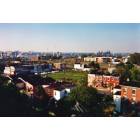
Having grown up and lived in Collingswood for over 20 years, I still can't tell you where the border actually sits on a street by street basis and most maps are no help at all, lol.
Looking at it again, as far as I can tell:
South of Atlantic Ave.
-Everything east of Ogden from the south side of Stokes through Belmont is Haddon Twp. Stokes is actually split with the north side of the street east of Ogden in Collingswood, while the south side is Haddon Twp. If you lived there, your neighbors across the street are literally in another town, lol.
-Everything south of Belmont and east of Lees Lane is in Haddon Twp.
North of Atlantic Ave.
-The section containing the Presbyterian Church and Krispy Kreme is in Collingswood. Though there is an interesting feature if you look at that site on the map. You can literally see an angled cut through the churches parking lot that extends from Cuthbert to the intersection of Lawnside Emerald and Homestead. Everything east of that line is Haddon Twp., everything west is Collingswood. So that means sections of Oriental, Penn and Linden as well as the entirety of Addison are in Haddon Twp.
-After that there is a clear distinction with everything northeast of Burmwood/Emerald being in Haddon Twp.
Wow, it's rather confusing, lol. So, for some reason that little "bump" with the church and KK is in Collingswood, but pretty much everything else north and south of that are in Haddon Twp. I'm guessing a blind, drunken monkey drew the map at some point.
Haha can't you guys just check the address on the receipt?
Doesn't always work do to the zipcodes, same with real estate listings. Haddon Township doesn't have a post office and sections of the town are covered by 08104, 08107, 08108 and 08033.
08104 is Camden and covers the sections of Haddon Twp. west of Route 130.
08107 is Oaklyn and that covers the sections of Haddon Twp. along the White Horse Pike and the part between Audubon and Gloucester City.
08108 is Collingswood and that covers all of Westmont and the sections of Haddon Twp. closest/pretty much in Collingswood.
08033 is Haddonfield and covers portions of Haddon Twp. that border Haddonfield directly.
Many places don't use the Westmont/Haddon Twp. name on things. For instance the Wawa on the corner of Cuthbert and Haddon lists their address as Collingswood, but that is most definitely in Haddon Twp. The PJ Whelihans on Haddon Ave. is actually in Haddon Twp., but they claim and use a Haddonfield address.
Even a lot of real estate listings for houses that are definitely in Westmont or Haddon Twp. will often show up with Collingswood or Oaklyn addresses on the listings.
Those blind, drunken monkeys are notoriously poor cartographers.
Thanks for the detail, Goat! That's good to know.
Don't give me too much credit, a page back I was quite certain KK was in Haddon Twp., lol. It took looking at the Google Map and the county map (off wikipedia) to sort of see where the sections were.
Having grown up and lived in Collingswood for over 20 years, I still can't tell you where the border actually sits on a street by street basis and most maps are no help at all, lol.
Looking at it again, as far as I can tell:
South of Atlantic Ave.
-Everything east of Ogden from the south side of Stokes through Belmont is Haddon Twp. Stokes is actually split with the north side of the street east of Ogden in Collingswood, while the south side is Haddon Twp. If you lived there, your neighbors across the street are literally in another town, lol.
-Everything south of Belmont and east of Lees Lane is in Haddon Twp.
North of Atlantic Ave.
-The section containing the Presbyterian Church and Krispy Kreme is in Collingswood. Though there is an interesting feature if you look at that site on the map. You can literally see an angled cut through the churches parking lot that extends from Cuthbert to the intersection of Lawnside Emerald and Homestead. Everything east of that line is Haddon Twp., everything west is Collingswood. So that means sections of Oriental, Penn and Linden as well as the entirety of Addison are in Haddon Twp.
-After that there is a clear distinction with everything northeast of Burmwood/Emerald being in Haddon Twp.
Wow, it's rather confusing, lol. So, for some reason that little "bump" with the church and KK is in Collingswood, but pretty much everything else north and south of that are in Haddon Twp. I'm guessing a blind, drunken monkey drew the map at some point.
That's absurd haha. How do schooling and police work? Does everyone within the town go to Haddon Twp. High School?
Also, looking at the Wikipedia map, it looks like there are two exclaves called West Collingswood, how do those fit into this mess?
Please register to post and access all features of our very popular forum. It is free and quick. Over $68,000 in prizes has already been given out to active posters on our forum. Additional giveaways are planned.
Detailed information about all U.S. cities, counties, and zip codes on our site: City-data.com.

 Please register to participate in our discussions with 2 million other members - it's free and quick! Some forums can only be seen by registered members. After you create your account, you'll be able to customize options and access all our 15,000 new posts/day with fewer ads.


 It took looking at the Google Map and the county map (off wikipedia) to sort of see where the sections were.