Please register to participate in our discussions with 2 million other members - it's free and quick! Some forums can only be seen by registered members. After you create your account, you'll be able to customize options and access all our 15,000 new posts/day with fewer ads.
Does anyone know of a detailed map (with street names) of the different neighborhoods in Newark?
Anyway, I am also trying to settle once and for all how the neighborhoods rate in terms of safety. Please use the following categories for safety (assuming the visitor has a complexion that makes him stand out)...
Green - Safe
Yellow - Safe during day - dangerous at night
Yellow/Red - Main Avenues Safe during Day - dangerous at night.
Red - Dangerous
Bright Red - War Zone
So far, I got the following
Forest Hills - Green
Ivy Hill - Yellow or maybe green
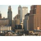
Downtown (by skyscrapers) yellow or maybe green
Ironbound - green
But what are the names of the rest of the neighborhoods? Where would they rank?
(((I am interesting in Newark because it is our largest city but when people are always taking about the different areas, I am a bit confused still)))
What is this the Middle East? I'll play along though. But there's no difference between Red and Bright Red, so I'll use Red separately. To me, Red means you shouldn't be there period:
Clinton Hill--Red
Vailsburg--Yellow(mostly Green southwest of Sanford/SO Aves towards Ivy Hill)
Ivy Hill--Green(except along Mt. Vernon Place, that's Red)
Upper Roseville--Yellow; Lower Roseville--Red
Springfield/Belmont--Yellow along Springfield Ave and around the new residental areas, Red anywhere else
Mt. Pleasant/Broadway--Yellow except for the projects
Fairmount: Red
West Side: Red
Weequahic: Red west of Bergen Street, Yellow/Green to Weequahic Park
7th Avenue: Yellow
Dayton: Red
Lincoln Park: Yellow
University Heights: Yellow(Green in and around the campuses)
Wikipedia has a list of these neighborhoods and you can match em up with the map on Google.
North Ward
Broadway: Green/Yellow
Forest Hill: Green
Mt. Pleasant/Lower Broadway: Yellow/red
Roseville: yellow
7th Ave: yellow
South Ward
Clinton Hill: Yellow/red
Dayton: yellow/red (Boyden Terrace = bright red)
South Broad Valley: red
Weeqhaic: yellow
Central Ward
Lincoln Park: yellow
Gov't center: yellow/green
Belmont: red
University Heights: green
East Ward
5 Corners: green
The Ironbound: green
Downtown: green
West Ward
Fairmount: Red
Ivy Hill: yellow/red
Vailsburg: red, some parts bright red
West Side: red, bright red in some parts
Yeah Ironbound looks pretty good esp around Prudential Center, I know it from McCarter Hwy, never got off that road though. I know it's a few blocks away from Broad St which is supposedly fine, but I'm worried about the streets that I would take from McCarter to get to Broad. Newark fascinates me more and more. Just from knowing people who were born and raised there before it got real bad, telling me how great it used to be. It'd be nice if it got fixed up again because it does seem like it has a lot of potential.
Vailsburg is right next to East Orange. Drove through there once during the day and freaked out at the sight of it. Had to drive a friend, who is semi-ghetto-obsessed, to some class in East Orange and dropped him off and sped out as quick as possible.
Green:Fairly safe throughout the neighborhood
Forest Hill
North Broadway
Seventh Ave
Ironbound
Yellow:Fairly Safe in the predominantly residential areas only
Central Business District
South Broad St.
Lower Clinton Hill
Upper Roseville
(I'll throw in orange) Orange: Pretty dangerous, not the worst in the city.
Upper Clinton Hill
Springfield/Belmont
Upper Valisburg
Red: The worst neighborhoods in Newark West Side
Fairmount
Lower Valisburg
Lower Roseville
Green:Fairly safe throughout the neighborhood
Forest Hill North Broadway Seventh Ave
Ironbound
Yellow:Fairly Safe in the predominantly residential areas only Central Business District
South Broad St. Lower Clinton Hill
Upper Roseville
(I'll throw in orange) Orange: Pretty dangerous, not the worst in the city.
Upper Clinton Hill
Springfield/Belmont Upper Valisburg
No way Upper Vailsburg(next to South Orange) is worse than anything in Clinton Hill. Walked through the former and the latter several times, and UV is Millburn compared to that dump. And even though the CBD is outdated and sometimes dreadful for 2010, it's not worse than 7th Ave or North Broadway.
Please register to post and access all features of our very popular forum. It is free and quick. Over $68,000 in prizes has already been given out to active posters on our forum. Additional giveaways are planned.
Detailed information about all U.S. cities, counties, and zip codes on our site: City-data.com.

 Please register to participate in our discussions with 2 million other members - it's free and quick! Some forums can only be seen by registered members. After you create your account, you'll be able to customize options and access all our 15,000 new posts/day with fewer ads.