Please register to participate in our discussions with 2 million other members - it's free and quick! Some forums can only be seen by registered members. After you create your account, you'll be able to customize options and access all our 15,000 new posts/day with fewer ads.
I live in Florida and have been watching this whole Sandy thing, and even though it is good to prepare and to keep people informed on the possible event, there are something that are not making any sense to me, and I am talking how The Weather Channel is handling this.
They are talking like this is going to be worse than Irene and for the experience here with Isaac it all resulted in a big hysteria. Nothing significant happened in the peninsular area and they made people believe it was going to be kind of massive.
I suggest preparing but keep an eye on NOAA. Remember we are nearing elections and this could all be a big economic hoax, I mean prepare, because the projections are putting Sandy entering the area (I am not sure yet if Sandy will obliterate before or if something pulls it to the east, it's not like it's really close to be sure it will hit the area) but don't get neurotic and frantic. My advice.
I stopped watching TWC and visiting their website. The script for every live report is the same, "EHRMERGERD!! WURZT STURRM EVARRR!" I just go to the NWS website. Just the facts, no sensationalizing.
This video from CNN illustrates the hype quite well.
My European friends wind modals show it from 20-30mph with gusts up to 45mph for Tuesday....not the 50-60mph the TWC predicts...in line with other stations....lately the TWC has been geting the local forcast wrong..
My European friends wind modals show it from 20-30mph with gusts up to 45mph for Tuesday....not the 50-60mph the TWC predicts...in line with other stations....lately the TWC has been geting the local forcast wrong..
Sure looks like 50-60mph gusts to me. You're looking too late I think.
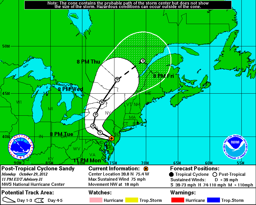
Don't see a surface Euro chart, but 850mb shows 80kt winds at that altitude. Quick googling says converting down to surface speeds is a 0.8 factor, or 64mph winds. http://www.instantweathermaps.com/EC...850mb&hour=072
All of which makes sense, seeing as the NHC chart has it as a hurricane a couple hours before landfall, which means >73mph winds at that time.
Note: I am not a professional met, or even particularly educated on the weather, just been following this storm for a few days.
Sure looks like 50-60mph gusts to me. You're looking too late I think.
Don't see a surface Euro chart, but 850mb shows 80kt winds at that altitude. Quick googling says converting down to surface speeds is a 0.8 factor, or 64mph winds. Instant Weather Maps
All of which makes sense, seeing as the NHC chart has it as a hurricane a couple hours before landfall, which means >73mph winds at that time.
Note: I am not a professional met, or even particularly educated on the weather, just been following this storm for a few days.
Alot of maps have it downgraded to a strong Low with winds of 50mph....then losing even more steam to 35mph winds....but it all depends on where u live. I live closer to New York state in a shielded valley , the winds tend to be 15mph less then on the other sides oh the hill...but they said 40-50mph gusts on tuesday...with 20-35mph winds... Irene was alot worse then that...
I live in Florida and have been watching this whole Sandy thing, and even though it is good to prepare and to keep people informed on the possible event, there are something that are not making any sense to me, and I am talking how The Weather Channel is handling this.
They are talking like this is going to be worse than Irene and for the experience here with Isaac it all resulted in a big hysteria. Nothing significant happened in the peninsular area and they made people believe it was going to be kind of massive.
I suggest preparing but keep an eye on NOAA. Remember we are nearing elections and this could all be a big economic hoax, I mean prepare, because the projections are putting Sandy entering the area (I am not sure yet if Sandy will obliterate before or if something pulls it to the east, it's not like it's really close to be sure it will hit the area) but don't get neurotic and frantic. My advice.
NOAA is calling for a higher storm surge than Irene.
And here in Sandy Hook, they ran their big ships off shore and tucked their smaller ones (50ft) way out of the way up the Arthur Kill.
I don't think either action is neurotic or frantic.
Reality is there is a good chance for loss of power, and even more significant time period than Irene. And there is an even greater chance for coastal flooding. And that is according to NOAA.
Alot of maps have it downgraded to a strong Low with winds of 50mph....then losing even more steam to 35mph winds....but it all depends on where u live. I live closer to New York state in a shielded valley , the winds tend to be 15mph less then on the other sides oh the hill...but they said 40-50mph gusts on tuesday...with 20-35mph winds... Irene was alot worse then that...
Depends on where you are. I live in Squan and work on Sandy Hook. This will likely be worse than Irene in terms of max. winds and flooding.
My European friends wind modals show it from 20-30mph with gusts up to 45mph for Tuesday....not the 50-60mph the TWC predicts...in line with other stations....lately the TWC has been geting the local forcast wrong..
Which would be relevant if the strongest predicted winds were for Tues. Strongest predicted winds are for Monday in NJ.
Please register to post and access all features of our very popular forum. It is free and quick. Over $68,000 in prizes has already been given out to active posters on our forum. Additional giveaways are planned.
Detailed information about all U.S. cities, counties, and zip codes on our site: City-data.com.

 Please register to participate in our discussions with 2 million other members - it's free and quick! Some forums can only be seen by registered members. After you create your account, you'll be able to customize options and access all our 15,000 new posts/day with fewer ads.