Please register to participate in our discussions with 2 million other members - it's free and quick! Some forums can only be seen by registered members. After you create your account, you'll be able to customize options and access all our 15,000 new posts/day with fewer ads.
Looking to purchase a house in Branchburg, specifically off of Burnt Mills road. Should I be concerned about flooding, presumably because its proximity to the Raritan River? If so, do things get bad only after Sandy like weather or is it pretty common? Thanks.
Looking to purchase a house in Branchburg, specifically off of Burnt Mills road. Should I be concerned about flooding, presumably because its proximity to the Raritan River? If so, do things get bad only after Sandy like weather or is it pretty common? Thanks.
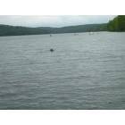
Burnt Mills Rd at the Lamington River is frequently closed do to flooding. While the home you are looking at may not itself flood, access to the home is likely to be an issue, as when the road is closed, you may not be able to get to or out of your home. Also the some of the area is subject to mandatory evacuations during flood threats. Not all homes are affected though as the topography in the area includes some hills. Best bet would be to call/contact the township and talk with their Emergency Management Council head, Sgt. Kevin Anderson. here is a link to their website Branchburg Township New Jersey Branchburg Township New Jersey
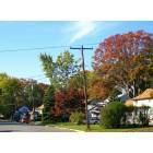
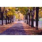
Please bear in mind that this isnt reflective of most of Branchburg. Burnt Mills road is a BEAUTIFUL area, but although it is in Branchburg, it may as well be in Bedminster because of it's location. However, it is classified as Branchburg, so that's who you pay taxes to, and that's where the kids will go to school.
Please bear in mind that this isnt reflective of most of Branchburg. Burnt Mills road is a BEAUTIFUL area, but although it is in Branchburg, it may as well be in Bedminster because of it's location. However, it is classified as Branchburg, so that's who you pay taxes to, and that's where the kids will go to school.
It's pretty interesting to see Branchburg's transformation as one drives through town from North to South
The rockaway river joins up with the lamington river which flows into the north branch near burnt mill rd bridge. Only select areas flood and are well defined. floyd, being the one which set the boundaries. So no surprises what and where floods.
Also see the Branchburg news, a monthly paper for life in Bburg.
The area around burnt mills and the north border of Bburg is quite beautiful and open.
Please register to post and access all features of our very popular forum. It is free and quick. Over $68,000 in prizes has already been given out to active posters on our forum. Additional giveaways are planned.
Detailed information about all U.S. cities, counties, and zip codes on our site: City-data.com.

 Please register to participate in our discussions with 2 million other members - it's free and quick! Some forums can only be seen by registered members. After you create your account, you'll be able to customize options and access all our 15,000 new posts/day with fewer ads.