Please register to participate in our discussions with 2 million other members - it's free and quick! Some forums can only be seen by registered members. After you create your account, you'll be able to customize options and access all our 15,000 new posts/day with fewer ads.
There is not a big advantage to it, it's up to the person individually. I lived in Alamogordo because I worked there, that's my reason. One thing to think about is there's a lot of housing in Alamogordo for rent, if you like to rent. There are many for sale, too. But in some places it's difficult to get rentals, not so in Alamogordo, of course, it's subject to your credit rating, whether or not you have animals, etc.
Last edited by elkotronics; 02-08-2016 at 11:01 AM..
Then what is the advantage of living in Alamogordo over Las Cruces, if you have a choice? Las Cruces offers more of everything, if you want to live in southern NM. NMSU is a great cultural asset, and there are many more options for entertainment, dining, shopping, etc. in Las Cruces. If you're not stationed at Holloman AFB or tied to a job in Alamogordo, I don't see the point in living or retiring there.
If you value a slower pace, the great outdoors, a lower crime rate, lower COL, and slightly cooler temperatures, then Alamogordo wins.
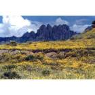
Alamogordo sits right next to a very nice mountain range and forest. Takes only a few minutes to get up there to cool off in the summer or play in the snow in winter. The closest mountains to Las Cruces are the ones next to Alamogordo.
The closest mountains to Las Cruces are the ones next to Alamogordo.
Not true. The Organ Mountains are almost as close to LC as the Sacramentos are to Alamo and while there isn't a road up into them in quite the same way, the Organs have lots of cool, green places for exploring and hiking within a very short distance of Las Cruces. The popular picnic area and hiking trailhead at Dripping Springs, for instance, is less than a half-hour from the Mesilla Valley Mall...
Alamogordo sits right next to a very nice mountain range and forest. Takes only a few minutes to get up there to cool off in the summer or play in the snow in winter. The closest mountains to Las Cruces are the ones next to Alamogordo.
I understand what you're trying to convey - that there are cool forested areas in easy reach from Alamogordo. And there are numerous opportunities for living in the forest, either as weekend getaways or for year-around living. I've known people who commute daily from both the Cloudcroft and Ruidoso areas to work in Alamogordo.
If I lived in Las Cruces, I'd probably toss a coin to decide whether to drive to the Gila Natl. Forest or the Lincoln Natl. Forest.
But as Cactus points out, there are many different un-forested mountain ranges within easy driving distance of both Alamogordo and Las Cruces. The Organ Mountains have two BLM recreation areas with good picnicking, camping and hiking opportunities, as well as now being designated as a National Monument.
The Organ Mountains have two BLM recreation areas with good picnicking, camping and hiking opportunities, as well as now being designated as a National Monument.
This area has some great hikes - one is on your right on Hwy.70 east to Alamogordo as you come down off of the Organ Mountains. It's name escapes me but I can guarantee you that you will love it for hiking. Right above the desert floor you'll find this trailhead to park at and then you go up the mountain towards Las Cruces. I'll never forget it's beauty and if the Mrs. and I do retire in the desert SW like we're planning we're gonna come back to this place.
It's just before you get down the hill and there's the White Sands Missile Range exiting to the right just a bit further down the hill. This area is beautiful - White Sands National Monument is worth seeing in all its grandeur, too.
T
This area has some great hikes - one is on your right on Hwy.70 east to Alamogordo as you come down off of the Organ Mountains. It's name escapes me...
You're thinking of Aguirre Springs (uh-gare-ay). The other BLM area on the west side is Dripping Springs.
There are similar recreation sites north and south of Alamogordo that are also good for day hikes, camping and picnicking year around:
>Three Rivers campground/petroglyphs.
>Oliver Lee State Park and Dog Canyon.
And don't want to overlook White Sands Nat. Monument between Las Cruces and Alamogordo.
You're thinking of Aguirre Springs (uh-gare-ay). The other BLM area on the west side is Dripping Springs.
Thanks, joqua. Also, there's a spot north of Tularosa where you can see the old Indian petroglyphs - it's 50-70 miles north of Tularosa. Very interesting hikes because of all the ancient artwork etched on the rocks there. Right off of Highway 54.
But as Cactus points out, there are many different un-forested mountain ranges
Yes, I haven't spent any time in the Organ Mountains, just passing through. They are pretty enough, but I never noticed much greenery. Nothing like the mountain range that runs through Ruidoso and Cloudcroft, or the Gila.
Yes, I haven't spent any time in the Organ Mountains, just passing through. They are pretty enough, but I never noticed much greenery. Nothing like the mountain range that runs through Ruidoso and Cloudcroft, or the Gila.
That is correct, the Organ Mountains are fairly brown. I'd like ta check out Dripping Springs on the west side of the Organ Mountains - on the Las Cruces side of the Organ Mountains. Dripping Springs will be pretty brown, too, but I'll bet it's beautiful. Anyone on city-data New Mexico ever been there?
That is correct, the Organ Mountains are fairly brown. I'd like ta check out Dripping Springs on the west side of the Organ Mountains - on the Las Cruces side of the Organ Mountains. Dripping Springs will be pretty brown, too, but I'll bet it's beautiful. Anyone on city-data New Mexico ever been there?
I have been to Dripping Springs a number of times and it is nice, but my favorite on the west side is Soledad Canyon. This is just to the south of Dripping Springs.
The video below begins at the end of the canyon up against the Organs where the waterfall is located. Of course you are very unlikely to find more than a trickle but on the day I took this video it was the most impressive flow I have yet seen. Towards the end of the video, some of the more open area of the canyon can be seen but it is still a ways from the parking lot.
I think the best route in Soledad is to take the first fork to the south soon after leaving the parking lot. This trail loops up to a higher elevation with nice views down into the flat part of the canyon and out to the valley. It then curves back down to the main trail in the wide and flatter section of the canyon. At the junction, going to the right then takes you to the narrow / waterfall section. It is a short distance in the narrow section to the "waterfall". On the way back out, we leave the main trail to loop to the north to go by a small stone structure, then work our way back to the main trail closer to the parking lot.
Please register to post and access all features of our very popular forum. It is free and quick. Over $68,000 in prizes has already been given out to active posters on our forum. Additional giveaways are planned.
Detailed information about all U.S. cities, counties, and zip codes on our site: City-data.com.

 Please register to participate in our discussions with 2 million other members - it's free and quick! Some forums can only be seen by registered members. After you create your account, you'll be able to customize options and access all our 15,000 new posts/day with fewer ads.


")