Please register to participate in our discussions with 2 million other members - it's free and quick! Some forums can only be seen by registered members. After you create your account, you'll be able to customize options and access all our 15,000 new posts/day with fewer ads.
Location: Used to live in Poughkeepsie, Staten Island, and Howard Beach
16 posts, read 16,611 times
Reputation: 23
Advertisements
I'm curious on what New Yorkers usually perceive/consider to be the border zone.
In my subjective opinion, I would guess somewhere in between Peekskill and Newburgh area(s)?
Perhaps westpoint?
Yet again, I don't know the validity of my opinion.
Just curious.
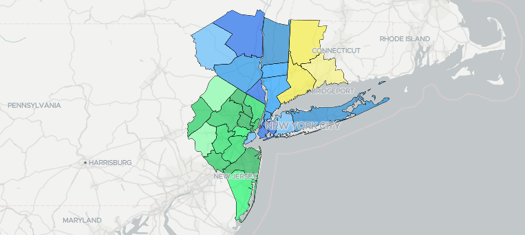
That map is the CSA (combined statistical area), which is geographically much larger than the MSA (metropolitan statistics area) where most of the area population lives and works. The MSA is more compact and more populous.
Practically speaking, I’d say you’re in metro NYC whenever a commute to Manhattan every day is doable fairly easily. So while Monroe County in the Poconos In Pennsylvania or Jersey shore places in Ocean County are in the larger CSA, I wouldn’t consider them metro NYC. Many folks, however will come in from Rockland, Durchess, and Putnam counties in NY. I think going north those counties are edge of an everyday commute for most folks.
Of course this has a lot to do with the access to commuter rail line and buses as well as highway access and conditions, though I’m sure some folks from further out places regularly do make these commutes.
Please register to post and access all features of our very popular forum. It is free and quick. Over $68,000 in prizes has already been given out to active posters on our forum. Additional giveaways are planned.
Detailed information about all U.S. cities, counties, and zip codes on our site: City-data.com.

 Please register to participate in our discussions with 2 million other members - it's free and quick! Some forums can only be seen by registered members. After you create your account, you'll be able to customize options and access all our 15,000 new posts/day with fewer ads.