Welcome to City-Data.com Forum!
U.S. CitiesCity-Data Forum Index
Go Back   City-Data Forum > U.S. Forums > North Carolina
 [Register]
Please register to participate in our discussions with 2 million other members - it's free and quick! Some forums can only be seen by registered members. After you create your account, you'll be able to customize options and access all our 15,000 new posts/day with fewer ads.
View detailed profile (Advanced) or search
site with Google Custom Search

Search Forums  (Advanced)
Reply Start New Thread
 
Old 03-06-2014, 09:09 AM
 
4,596 posts, read 6,427,227 times
Reputation: 4193

Advertisements

A Winter Weather Advisory has been issued for much of central and western North Carolina for today and tomorrow. As usual, computer models are all over the place with regards to the amount and form of precipitation the region will receive from this developing winter system. There is the potential for a significant snow in western North Carolina and significant ice in the foothills and Triad. The foothills and Triad may also see accumulating snow in addition to ice and sleet. This is a very complex and difficult storm to predict, and residents should prepare for the possibility of some power outages in central and western North Carolina. The biggest uncertainty is where a band of heavy, wet snow will develop tomorrow and how large that band will be. It could develop in the foothills or the Triad along the deformation band, but there is virtually no way to know now where it will occur.

Last edited by Tarheelhombre; 03-06-2014 at 09:24 AM..
Reply With Quote Quick reply to this message

 
Old 03-06-2014, 09:18 AM
 
4,596 posts, read 6,427,227 times
Reputation: 4193
From Meteorologis WxSouth:

WxSouth
Overall, I'm sticking with my map from yesterday. This is playing out about like this. Snow in northwest NC turns to sleet. Several inches of snow from Asheville to Boone to southwest VA mountains but the max snow should be near Boone to the middle NC foothills where most moisture arrives when its cold enough aloft. The worst part will be in Greensboro and just west of the Triangle down to middle NC, Salisbury, Hickory, Statesville to Forest City Marion areas where temps will fall into upper 20's during the night and freezing rain and sleet is falling hard. The high pressure remains inland all the way up until 7 am Friday morning, then we lose that tap of dry cold dewpoint air, and that allows temps at the surface to finally go above freezing.
For southern and middle Virginia, it depends on when the moisture comes that far north, while the high is still in position. It looks like the best moisture is arriving in Lynchburg to Richmond just around 7 to 10 am, and by then, the time of day and the fact the high is pulling out means less ice and snow threat there, so you see a tight graident on how this evolves. For upper SC, the models may not be quite cold enough. I don't trust the surface temps just yet when it shows the 32 line stopping at the GSP area, but it could.Its always looked close there.
For northeast GA, same..the sub 32 degree air could come into that region tonight and lock in at the surface. Its very close, adn that could mean a big ice storm there as well. don't let your guard down. This will come down to watching radars and temps, observations tonight, not the models anymore.
Bottom line is this looks pretty bad for the middle and western part of NC because of perfect timing and evolution of the storm. I expect some power outages by dawn tomorrow somewhere in the tarheel state and possibly for southern tier of counties in VA as well, possibly even northeast GA and upper SC too..
Map issued yesterday.
Reply With Quote Quick reply to this message
 
Old 03-06-2014, 09:43 AM
 
4,596 posts, read 6,427,227 times
Reputation: 4193
Duke Energy is in preparation mode:

Reply With Quote Quick reply to this message
 
Old 03-06-2014, 12:54 PM
 
4,596 posts, read 6,427,227 times
Reputation: 4193
Note: the all-caps are a feature of official National Weather Service watches and warnings, not my preference.

Winter Storm Warning for NC High Country

Snow: 2 to 5 inches

WWUS42 KGSP 061938
WSWGSP

URGENT - WINTER WEATHER MESSAGE
NATIONAL WEATHER SERVICE GREENVILLE-SPARTANBURG SC
238 PM EST THU MAR 6 2014

...SIGNIFICANT WINTER STORM EXPECTED TO IMPACT PORTIONS OF WESTERN
NORTH CAROLINA TONIGHT AND EARLY FRIDAY...

.A LOW PRESSURE SYSTEM DEVELOPING OVER THE NORTHEASTERN GULF OF
MEXICO WILL MOVE OFF THE SOUTHEAST COAST THIS EVENING.
PRECIPITATION WILL CONTINUE TO OVERSPREAD THE REGION THROUGH THE
EVENING. AS THE LOW PRESSURE SYSTEM INTENSIFIES OFF THE SOUTHEAST
COAST TONIGHT...COOLER AIR WILL SURGE DOWN FROM HIGH PRESSURE OVER
NEW ENGLAND. THE COOLER AIR WILL ALLOW THE PRECIPITATION TO CHANGE
OVER TO A WINTRY MIX ACROSS MUCH OF THE MOUNTAINS...PIEDMONT...AND
FOOTHILLS OF NORTH CAROLINA. THE PRECIPITATION SHOULD CHANGE TO
RAIN ON FRIDAY MORNING BEFORE ENDING.

NCZ033-049-050-053-064-065-501>507-509-070400-
/O.UPG.KGSP.WW.Y.0014.140306T2300Z-140307T1700Z/
/O.NEW.KGSP.WS.W.0006.140307T0000Z-140307T1700Z/
AVERY-YANCEY-MITCHELL-BUNCOMBE-TRANSYLVANIA-HENDERSON-
CALDWELL MOUNTAINS-GREATER CALDWELL-BURKE MOUNTAINS-GREATER BURKE-
MCDOWELL MOUNTAINS-EASTERN MCDOWELL-RUTHERFORD MOUNTAINS-
POLK MOUNTAINS-
INCLUDING THE CITIES OF...NEWLAND...SPRUCE PINE...ASHEVILLE...
BREVARD...HENDERSONVILLE
238 PM EST THU MAR 6 2014

...WINTER STORM WARNING IN EFFECT FROM 7 PM THIS EVENING TO NOON
EST FRIDAY...

THE NATIONAL WEATHER SERVICE IN GREENVILLE-SPARTANBURG HAS ISSUED
A WINTER STORM WARNING FOR SNOW...SLEET...AND FREEZING RAIN...WHICH
IS IN EFFECT FROM 7 PM THIS EVENING TO NOON EST FRIDAY. THIS
REPLACES THE WINTER WEATHER ADVISORY.

* LOCATIONS...THE EASTERN BLUE RIDGE ESCARPMENT...AND THE NORTHERN
FOOTHILLS OF NORTH CAROLINA.

* HAZARDS...HEAVY SNOW AND SLEET ACCUMULATIONS TONIGHT...THEN
POSSIBLE LIGHT ICE ACCUMULATION FRIDAY MORNING.

* TIMING...SNOW AND SLEET WILL DEVELOP OVER THE AREA DURING EARLY
TO MID EVENING. PRECIPITATION WILL CHANGE MAINLY TO SLEET
DURING THE EARLY MORNING HOURS...POSSIBLY CHANGING TO FREEZING
RAIN BEFORE CHANGING TO ALL RAIN BY LATE FRIDAY MORNING.

* ACCUMULATIONS...SNOW AND SLEET ACCUMULATION OF 2 TO 5 INCHES... ALONG
WITH AROUND A TRACE OF ICE.

* IMPACTS...SLIPPERY ROADS DUE TO THE COMBINATION OF SNOW...
SLEET... AND ICE.

* TEMPERATURES...LOWS IN THE LOWER 30S.

* WINDS...NORTHEAST 5 TO 15 MPH WITH GUSTS UP TO 25 MPH.

PRECAUTIONARY/PREPAREDNESS ACTIONS...

A WINTER STORM WARNING MEANS SIGNIFICANT AMOUNTS OF SNOW...
SLEET...AND ICE ARE EXPECTED OR OCCURRING. GUSTY WINDS ARE ALSO
POSSIBLE. THIS WILL MAKE TRAVEL VERY HAZARDOUS OR IMPOSSIBLE.

PLEASE REPORT SNOW AND ICE ACCUMULATIONS...AS WELL AS ANY DAMAGE
TO TREES OR STRUCTURES...BY CALLING THE NATIONAL WEATHER SERVICE
TOLL FREE AT...1...800...2 6 7...8 1 0 1. LEAVE A MESSAGE WITH
YOUR OBSERVATION AND THE SPECIFIC LOCATION WHERE IT OCCURRED. YOU
CAN ALSO POST YOUR REPORT TO NATIONAL WEATHER SERVICE GREENVILLE
SPARTANBURG FACEBOOK OR TWEET YOUR REPORT USING HASHTAG NWSGSP.
Reply With Quote Quick reply to this message
 
Old 03-06-2014, 12:56 PM
 
4,596 posts, read 6,427,227 times
Reputation: 4193
And the I-40 corridor also has been upgraded to a Winter Storm Warning.


NCZ035>037-056-057-070400-
/O.UPG.KGSP.WW.Y.0014.140306T2300Z-140307T1700Z/
/O.NEW.KGSP.WS.W.0006.140307T0000Z-140307T1700Z/
ALEXANDER-IREDELL-DAVIE-CATAWBA-ROWAN-
INCLUDING THE CITIES OF...STATESVILLE...MOCKSVILLE...HICKORY...
SALISBURY
238 PM EST THU MAR 6 2014

...WINTER STORM WARNING IN EFFECT FROM 7 PM THIS EVENING TO NOON
EST FRIDAY...

THE NATIONAL WEATHER SERVICE IN GREENVILLE-SPARTANBURG HAS ISSUED
A WINTER STORM WARNING FOR SLEET AND FREEZING RAIN...WHICH IS IN
EFFECT FROM 7 PM THIS EVENING TO NOON EST FRIDAY. THIS REPLACES
THE WINTER WEATHER ADVISORY.

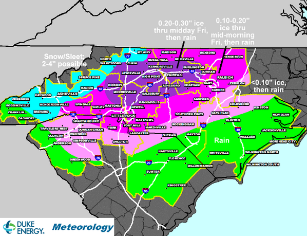
* LOCATIONS...THE NORTHWEST PIEDMONT OF NORTH CAROLINA.

* HAZARDS...HEAVY ACCUMULATIONS OF SLEET AND FREEZING RAIN.

* TIMING...A MIX OF RAIN AND SLEET WILL CHANGE OVER MAINLY TO
SLEET THIS EVENING...AND THEN FREEZING RAIN DURING THE EARLY
MORNING HOURS ON FRIDAY. THE PRECIPITATION SHOULD CHANGE TO ALL
RAIN SHORTLY AFTER DAYBREAK FRIDAY.

* ACCUMULATIONS...SLEET ACCUMULATION OF UP TO 1 INCH...ALONG WITH
AROUND ONE QUARTER OF AN INCH OF ICE.

* IMPACTS...DANGEROUS DRIVING CONDITIONS DUE TO SLEET AND
FREEZING RAIN. SCATTERED POWER OUTAGES DUE TO HEAVY ICE
ACCUMULATIONS.

* TEMPERATURES...LOWS TONIGHT AROUND 30.

* WINDS...NORTHEAST 10 TO 20 MPH WITH GUSTS UP TO 30 MPH.

PRECAUTIONARY/PREPAREDNESS ACTIONS...

A WINTER STORM WARNING MEANS SIGNIFICANT AMOUNTS OF SNOW...
SLEET...AND ICE ARE EXPECTED OR OCCURRING. STRONG WINDS ARE ALSO
POSSIBLE. THIS WILL MAKE TRAVEL VERY HAZARDOUS OR IMPOSSIBLE.

PLEASE REPORT SNOW AND ICE ACCUMULATIONS...AS WELL AS ANY DAMAGE
TO TREES OR STRUCTURES...BY CALLING THE NATIONAL WEATHER SERVICE
TOLL FREE AT...1...800...2 6 7...8 1 0 1. LEAVE A MESSAGE WITH
YOUR OBSERVATION AND THE SPECIFIC LOCATION WHERE IT OCCURRED. YOU
CAN ALSO POST YOUR REPORT TO NATIONAL WEATHER SERVICE GREENVILLE
SPARTANBURG FACEBOOK OR TWEET YOUR REPORT USING HASHTAG NWSGSP.

STAY TUNED TO NOAA WEATHER RADIO OR YOUR FAVORITE SOURCE OF
WEATHER INFORMATION FOR THE LATEST UPDATES. ADDITIONAL DETAILS
CAN BE FOUND AT Greer, SC
Reply With Quote Quick reply to this message
 
Old 03-06-2014, 04:39 PM
 
Location: Chapelboro
12,799 posts, read 16,336,102 times
Reputation: 11237
I am so done with winter. Anticipating another school issue tomorrow. Will it be just a delayed opening or another snow day. Hope just a delayed opening.
Reply With Quote Quick reply to this message
 
Old 03-06-2014, 08:51 PM
 
Location: Winston-Salem
4,218 posts, read 8,530,941 times
Reputation: 4494
We've got 2-3 inches of snow at the foot of Grandfather Mountain and it still laying it down. The official weather report is calling it "wintry mix." When it first started around 6:00 pm, it was snow and sleet mixed, but it's been all snow for the past 2-3 hours. It's covering everything including pavement.
Reply With Quote Quick reply to this message
 
Old 03-07-2014, 04:41 AM
 
4,596 posts, read 6,427,227 times
Reputation: 4193
lots of power outages in the Triad and central NC
Reply With Quote Quick reply to this message
 
Old 03-07-2014, 05:24 AM
 
4,596 posts, read 6,427,227 times
Reputation: 4193
Tim Buckley ‏@TimBuckleyWX 26m

185k+ without power in NC. 47k in Guilford, 33k Randolph, 31k Alamance, 10k Forsyth. (Via @DukeEnergy) #TriadWx #IceStorm
Reply With Quote Quick reply to this message
 
Old 03-07-2014, 07:32 AM
 
4,596 posts, read 6,427,227 times
Reputation: 4193
LATEST: 81% of Duke Energy customers in Randolph Co. without power.
Reply With Quote Quick reply to this message
Please register to post and access all features of our very popular forum. It is free and quick. Over $68,000 in prizes has already been given out to active posters on our forum. Additional giveaways are planned.

Detailed information about all U.S. cities, counties, and zip codes on our site: City-data.com.


Reply
Please update this thread with any new information or opinions. This open thread is still read by thousands of people, so we encourage all additional points of view.

Quick Reply
Message:


Over $104,000 in prizes was already given out to active posters on our forum and additional giveaways are planned!

Go Back   City-Data Forum > U.S. Forums > North Carolina
Similar Threads

All times are GMT -6. The time now is 12:28 AM.

© 2005-2024, Advameg, Inc. · Please obey Forum Rules · Terms of Use and Privacy Policy · Bug Bounty

City-Data.com - Contact Us - Archive 1, 2, 3, 4, 5, 6, 7, 8, 9, 10, 11, 12, 13, 14, 15, 16, 17, 18, 19, 20, 21, 22, 23, 24, 25, 26, 27, 28, 29, 30, 31, 32, 33, 34, 35, 36, 37 - Top