Please register to participate in our discussions with 2 million other members - it's free and quick! Some forums can only be seen by registered members. After you create your account, you'll be able to customize options and access all our 15,000 new posts/day with fewer ads.
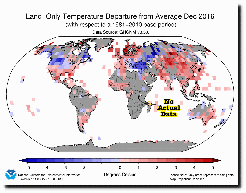
Don't have temperature data for a region? Just make it up.
-------------
The map above is fake. NOAA has almost no temperature data from Africa, and none from central Africa. They simply made up the record temperatures.
Satellites show that NOAA’s” record hot regions in Africa were actually close to normal
Gavin Schmidt at NASA claims the imaginary NOAA data has been replicated by many other institutions.
However, when Gavin is confronted about his obviously bogus temperature graphs, he defends by saying “it is not my data, I get it from NOAA.” In fact, all of the supposedly independent agencies get the lion’s share of their data from NOAA.
Where did the data even come from? Maybe some links to the sources so that thinking people can look at what actually happened and make reasonable conclusions?
As usual, this is just garbage with no actual information, intended to dupe those who blindly accept the first thing they hear that they wish to be true.
Just more of the standard denier nonsense. No meat.
It's more than that. OP is probably A) scientifically illiterate or B) in a state of frenzy over climate science.
It's not my job to respond to the OP, but for the sake of anyone else clicking on this thread:
The Global Historical Climatology Network's (GHCN) 3rd version uses highly detailed mean temperature data, which most stations on the African continent have only been using for the past decade or two. Most of Africa isn't colored because the registered stations that are in use on the continent simply have no 30-year mean temperature data for the period 1981-2010. Here are the GHCN's (v3) meteorological stations and their age:
That isn't to say scientists have no data on Africa's climatological history. In addition to roughly 50 stations on Africa, which are GHCN v3-certified has having data going back to 1900, the distribution of those stations is fairly good. In addition, there is significant maximum and minimum station data in Africa for the second half of the 20th Century, thanks to the Colonial Era Archive project. (I suggest reading the GHCN methodology)
These sources -- plus others I'm probably unaware -- of data are used to form analyses like the Global Analysis - December 2016.
The work isn't even close to done at this point. Scientists then review the analysis with meteorological data, which is extremely extensive with modern technology. They look at the meteorological history of the period being analyzed, atmospheric conditions, etc. to confirm the findings.
For December, the NOAA explicitly said the month's 500 millibar height and anomalies, where ridges and troughs developed, correlated with "areas of positive and negative temperature anomalies at the surface, respectively."
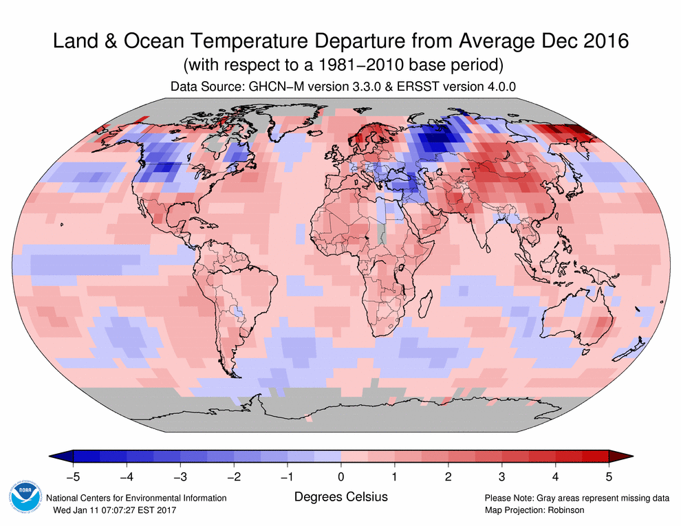
Don't have temperature data for a region? Just make it up.
-------------
The map above is fake. NOAA has almost no temperature data from Africa, and none from central Africa. They simply made up the record temperatures.
Satellites show that NOAA’s” record hot regions in Africa were actually close to normal
Gavin Schmidt at NASA claims the imaginary NOAA data has been replicated by many other institutions.
However, when Gavin is confronted about his obviously bogus temperature graphs, he defends by saying “it is not my data, I get it from NOAA.” In fact, all of the supposedly independent agencies get the lion’s share of their data from NOAA.
Sea ice in the Arctic and the Antarctic set record low extents every day in December, continuing the pattern that began in November. Warm atmospheric conditions persisted over the Arctic Ocean, notably in the far northern Atlantic and the northern Bering Sea. Air temperatures near the Antarctic sea ice edge were near average. For the year 2016, sea ice extent in both polar regions was at levels well below what is typical of the past several decades.
Please register to post and access all features of our very popular forum. It is free and quick. Over $68,000 in prizes has already been given out to active posters on our forum. Additional giveaways are planned.
Detailed information about all U.S. cities, counties, and zip codes on our site: City-data.com.

 Please register to participate in our discussions with 2 million other members - it's free and quick! Some forums can only be seen by registered members. After you create your account, you'll be able to customize options and access all our 15,000 new posts/day with fewer ads.