Please register to participate in our discussions with 2 million other members - it's free and quick! Some forums can only be seen by registered members. After you create your account, you'll be able to customize options and access all our 15,000 new posts/day with fewer ads.
Haha, yeah, that artist got a little creative. I think the road goes under the railroad there.
From your description the road goes under the tracks on a nightmare hill that goes up to Mellow Mushroom and Glenwood ave. That hill is a pain. They have made the right lane turn only and then you have Mellow Mushroom and McDonald's at the top of the hill. Oh, and did I say the train bridge has a really low clearance for assorted trucks that try to make it up the hill?
The rendering isn’t 100% of course, but it isn’t as crazy off as it seems. I can’t quite get as low using Apple Maps 3D view, but here is something close-ish. Now, I wonder what that building in the bottom left of the rendering is?
The rendering isn’t 100% of course, but it isn’t as crazy off as it seems. I can’t quite get as low using Apple Maps 3D view, but here is something close-ish. Now, I wonder what that building in the bottom left of the rendering is?
The building in the bottom left of the rendering is the parking deck on the back of the Peace project that's under construction. It's the project that's going to have the Publix and 400+ apartments that faces Peace St. between West and Harrington.
As to the comments regarding the canyon, this specific area actually does sit at the lowest point of downtown according to topo maps. To its immediate west, the neighborhood rises up to Glenwood on Peace Street, and to its east, there's the berm that elevates Capital Blvd as it passes through the neighborhood. On both the east and west, there are also elevated train tracks as well with their own berms. Traversing either north or south from this area on West St., one ascends a hill in each direction. So, in effect, this is like a canyon.
Back in the day, this neighborhood was known as Smokey Hollow and was a poor working class neighborhood in support of the nearby mills. It was called as such because the smoke from the mills would hang in this low lying area. Kane has resurrected that name for Phase 2 of the project represented by the OPs rendering.
they are steep embankments from road level up to track level right there. all you have to do is physically go to West St, and see how they look at W Johnson & Tucker
The rendering isn’t 100% of course, but it isn’t as crazy off as it seems. I can’t quite get as low using Apple Maps 3D view, but here is something close-ish. Now, I wonder what that building in the bottom left of the rendering is?
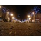
Sheriff, I think that's a photo, not a rendering. The view is looking toward the southeast. The red building in the lower left was Flythe bicycles and the food place in the lower right is MoJoe's Burger joint on Glenwood and Peace.
Sheriff, I think that's a photo, not a rendering. The view is looking toward the southeast. The red building in the lower left was Flythe bicycles and the food place in the lower right is MoJoe's Burger joint on Glenwood and Peace.
He's talking about the rendering of the proposed development in the first post.
Sheriff, I think that's a photo, not a rendering. The view is looking toward the southeast. The red building in the lower left was Flythe bicycles and the food place in the lower right is MoJoe's Burger joint on Glenwood and Peace.
The thing I posted is a screenshot from Apple Maps 3D view trying to match the angle from the rendering.
doesn't say; under current economic conditions doesn't really matter. Neither Williams Realty nor John Kane have been "risk it all" kind of operators.
in the artist rendering, the tallest building is NOT some 40-story new building. It's the West condo building.
As stated by another forumer, the rendering is of Phase 2, not Phase 3. The former will feature a 9-story office building and a couple of 6/7 story residential buildings.
As for Phase 3, I believe that we will not see anything near 40 floors tall. My guess is that the developers will build something similar to The Walter, which will be about 32 floors, but I will keep an open mind. Maybe something between 25 and 30 floors.
@wizard-xyzzy: You are correct. The fire department has suggested that buildings over 40 floors will be tougher to deal with in the case of fire and advised against them. Of course, there is nothing to stop a developer from delivering something taller, as long as the market is there and all other necessary requirements are in place. Not that I expect to see high-rises over 40 floors in Downtown Raleigh any time soon.
Can't wait to see the West Str and Harrington Str corridors after the known proposals are built. These two streets carry massive potential that few have realized thus far. Kane is one of them.
Please register to post and access all features of our very popular forum. It is free and quick. Over $68,000 in prizes has already been given out to active posters on our forum. Additional giveaways are planned.
Detailed information about all U.S. cities, counties, and zip codes on our site: City-data.com.

 Please register to participate in our discussions with 2 million other members - it's free and quick! Some forums can only be seen by registered members. After you create your account, you'll be able to customize options and access all our 15,000 new posts/day with fewer ads.