Please register to participate in our discussions with 2 million other members - it's free and quick! Some forums can only be seen by registered members. After you create your account, you'll be able to customize options and access all our 15,000 new posts/day with fewer ads.
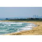
I had “heard” that you can easily walk from Imperial Beach (in a very short amount of time from the Imperial Beach Pier) to the Mexico border/fence (where the fence ends at the ocean). Yet when I tried to walk from the Imperial Beach Pier (the last time I was there), I swear I had walked south of the pier at least 2 miles and it just seemed that the beach became impassable and I could not see any sign of the border/fence, so I turned around and went back to the pier. So I was wondering 2 things . . . about how many miles is the Mexico border/fence (via walking south of the Imperial Beach pier)? Is it an easy and short walk that would take 30 minutes or less (or is the terrain at the beach so bad that the more you walk south, that it is not advisable to walk for the pier to the border)?
Now with that being said, I see on Google maps, that there is a place called “Border Field State Park”, and it seems if I could go as far southwest of that park, that I "might" get to the border/fence . . . however it does not look like there are any roads near the southwest area of the beach/terrain where I could just drive close to that area and then do a short walk to be somewhat near the border/fence. I don’t necessarily want to be so close to touch the border/fence, but it would be nice to see it from the beach, to be as near as a block or two away to see it . . . without a possibility of getting in trouble with the border patrol, being that close to the border/fence.
I know that there are many other options to see border away from the ocean, but I am only interested in trying to see the border/fence at the ocean.
I had “heard” that you can easily walk from Imperial Beach (in a very short amount of time from the Imperial Beach Pier) to the Mexico border/fence (where the fence ends at the ocean). Yet when I tried to walk from the Imperial Beach Pier (the last time I was there), I swear I had walked south of the pier at least 2 miles and it just seemed that the beach became impassable and I could not see any sign of the border/fence, so I turned around and went back to the pier. So I was wondering 2 things . . . about how many miles is the Mexico border/fence (via walking south of the Imperial Beach pier)? Is it an easy and short walk that would take 30 minutes or less (or is the terrain at the beach so bad that the more you walk south, that it is not advisable to walk for the pier to the border)?
I know that there are many other options to see border away from the ocean, but I am only interested in trying to see the border/fence at the ocean.
You can not walk from the IB pier to the border! Who ever told you that you could walk to the border from IB has obviously never looked at a map. You'd have to swim across the Tijuana River then walk several more miles to get to the border from the IB pier.
If you want to see the border fence run into the ocean, then Border Fields State Park is where you need to go. On the U.S. side is a lovely, deserted beach (well, deserted if you ignore the border patrol agents in their vehicles!), and you can walk up to about 20 feet from the fence and look through to see all of the people in Mexico having fun on their side of the beach. If you drive up to the picnic area, you can get a good view of the Bullring and look down into Tijuana.
The drive to Border Fields is an adventure if you haven't spent much time in more rural parts of San Diego County. You'll pass through Nestor which is actually the southern most section of the city of San Diego. Nestor is an interesting area where suburban tract homes give way to a semi-rural area filled with horse farms. You can even rent a horse there to ride on the beach. You'll also pass through the southern end of the Tijuana Estuary National Reserve -- it feels like another world and there are some nice walks down there. (The northern part of the Reserve can be accessed up in IB a few blocks from the pier)
However, Border Fields State Park is not open all the time, so be sure to check the website to see when it is open. The website also has directions on how to get to the park. Don't go if the park isn't open -- while it is possible to walk in, it is a long hot walk this time of year.
Location: San Diego CA>Tijuana, BC>San Antonio, TX
6,498 posts, read 7,528,555 times
Reputation: 6873
On a clear day you can see the fence and the Playas de Tijuana bull ring from the IB side, even from the pier.
Its been a few years, but in my more active days, we made it a summer goal to jog all the SD County beaches North to South one year and this was one of them. We did indeed jog from the Southern most point of Sea Coast Drive near the preserve all the way to about a few feet from the fence before being asked to turn around by the guys in green uniforms.
I remember there being a minor stream that one could easily hop over, this was the terminus of the TJ river. Perhaps there are certain points in the year when it's easier to cross than others. Jogging it took a while, I would imagine walking it would take quite a long time.
You can not walk from the IB pier to the border! Who ever told you that you could walk to the border from IB has obviously never looked at a map. You'd have to swim across the Tijuana River then walk several more miles to get to the border from the IB pier.
If you want to see the border fence run into the ocean, then Border Fields State Park is where you need to go. On the U.S. side is a lovely, deserted beach (well, deserted if you ignore the border patrol agents in their vehicles!), and you can walk up to about 20 feet from the fence and look through to see all of the people in Mexico having fun on their side of the beach. If you drive up to the picnic area, you can get a good view of the Bullring and look down into Tijuana.
The drive to Border Fields is an adventure if you haven't spent much time in more rural parts of San Diego County. You'll pass through Nestor which is actually the southern most section of the city of San Diego. Nestor is an interesting area where suburban tract homes give way to a semi-rural area filled with horse farms. You can even rent a horse there to ride on the beach. You'll also pass through the southern end of the Tijuana Estuary National Reserve -- it feels like another world and there are some nice walks down there. (The northern part of the Reserve can be accessed up in IB a few blocks from the pier)
However, Border Fields State Park is not open all the time, so be sure to check the website to see when it is open. The website also has directions on how to get to the park. Don't go if the park isn't open -- while it is possible to walk in, it is a long hot walk this time of year.
RosieSD, thank you so very, very much for your help. I so greatly appreciate you taking the time to read my post and reply back with such an AWESOME and detailed response.
I certainly thank you for bringing me up to date on how to best get to the border/fence. In that case, the next time I return to that area (making sure that the park will be open), I will go directly to “Border Field State Park”, and follow your suggestions. Based on what you shared, I am so glad that I did not try to walk from IB to that border/fence . . . as I sure would have been in for a very rude and horrible awakening! YIKES!!! I am so glad I turned back after walking about 2 miles. WHEW!!!
RosieSD, I send you a MILLION thanks for the link for the Border Field State Park. The next time that I return to San Diego, the first pitcher of Magaritas are on me.
On a clear day you can see the fence and the Playas de Tijuana bull ring from the IB side, even from the pier.
Its been a few years, but in my more active days, we made it a summer goal to jog all the SD County beaches North to South one year and this was one of them. We did indeed jog from the Southern most point of Sea Coast Drive near the preserve all the way to about a few feet from the fence before being asked to turn around by the guys in green uniforms.
I remember there being a minor stream that one could easily hop over, this was the terminus of the TJ river. Perhaps there are certain points in the year when it's easier to cross than others. Jogging it took a while, I would imagine walking it would take quite a long time.
Malcorub16, thank you so very kindly for your input and help. In my old age, about 2 miles of beach walking (in each direction), is about all I can do nowadays . . . I’m too old and out of shape to jog much anymore. Yet at least with the information that RosieSD provided, with my being able to drive to Border Field State Park, I am hoping once I get to the park, I can easily walk near enough to the boarder/fence in a timely manner. Yet the last time that I was at IB, I thought I was going to die just walking about 2 miles south of the IB pier . . . with absolutely nothing to show for my walk. That was not an easy walk for me, and I am so glad I finally had sense enough to turned around and walked back to the pier that day.
Thank you again so very much for your input and help.
On a clear day you can see the fence and the Playas de Tijuana bull ring from the IB side, even from the pier.
Its been a few years, but in my more active days, we made it a summer goal to jog all the SD County beaches North to South one year and this was one of them. We did indeed jog from the Southern most point of Sea Coast Drive near the preserve all the way to about a few feet from the fence before being asked to turn around by the guys in green uniforms.
I remember there being a minor stream that one could easily hop over, this was the terminus of the TJ river. Perhaps there are certain points in the year when it's easier to cross than others. Jogging it took a while, I would imagine walking it would take quite a long time.
Hmmm, interesting. How long ago was that?
I've been walking down to the point for the last couple of years, and the river always seems pretty wide at the end of the point. Given the sewage issues in the river, I wouldn't want to wade across there.
But, you're probably right about it filling with sand at certain times -- that end of seacoast seems to have constant flooding tides, and a few weeks ago, I remember hearing something about leopard sharks being stranded in the mouth of the river, so totally possible it could change at different times.
Thanks for that information, Malcorub; maybe one day I'll get lucky and be able to walk through too! But, for now, it's just easier to drive down to Border Fields when I want to get to the fence.
RosieSD, I have a quick question if you know the answer. If the gate to the is closed to vehicle traffic, but is open, where do people normally park to walk to Border Field State Park, and about how long is the walk from the parking area to get to the park?
RosieSD, I have a quick question if you know the answer. If the gate to the is closed to vehicle traffic, but is open, where do people normally park to walk to Border Field State Park, and about how long is the walk from the parking area to get to the park?
From the parking area to the beach is about a mile and a half. Then, you'll need to walk down the beach about a quarter of a mile to get to the fence. There isn't much shade there so it can be pretty hot in the summer - bring a hat and some water. When the gate is open, drive up to the top of the hill, where you'll find a picnic area and some restrooms. There is a really nice view of the San Diego skyline from there if you look north (away from the fence). If you want to ride a horse on the beach, there are a bunch of stables and horse farms in the Nestor/Dairy Mart Road area that rent them (if you happen to have your own horse, you can trailer it to the parking area and ride in. That's how I first experienced Border Fields ). It is definitely interesting to visit, especially when you look through the fence and see the people in Mexico looking back at you. They can walk right up to the fence on the Mexican side and even stick their heads and arms through the fence, but the US border patrol agents will tell you that you can't get closer than about 15/20 feet.
(If you want to actually go into Mexico, of course, you'll have to drive to one of the border crossings).
RosieSD, thank you so very, very much for providing the valuable and most helpful feedback. It really helps so very much. Thanks a MILLION!!!
In 1988, a friend and I walked from the southern portion of Imperial Beach into Tijuana. Back then the fence ended at the beach, and the final stretch of the fence by the bullfighting ring had fallen over. I don't know how safe or legal it was. We walked in November. In the morning, the Tijuana River was about knee deep. On the way back, the tide had risen, and we had to swim back. The swim back was scary. The tide was pushing inland, so there was no danger of being swept out to sea, but it was probably a dumb move regardless. We weren't aware of any sewage issue with the Tijuana River. The river didn't smell like sewage, but I don't recommend doing what we did.
We walked a few blocks into Mexico. The area was quiet, with no one really out, at least on the day we went. Maybe when there is a bullfight scheduled, more people are around. We walked along the promenade. Some of the buildings were dilapidated and had fallen onto the beach. We ate at a run-down cafe before going back. We were in Mexico no more than an hour or two.
Please register to post and access all features of our very popular forum. It is free and quick. Over $68,000 in prizes has already been given out to active posters on our forum. Additional giveaways are planned.
Detailed information about all U.S. cities, counties, and zip codes on our site: City-data.com.

 Please register to participate in our discussions with 2 million other members - it's free and quick! Some forums can only be seen by registered members. After you create your account, you'll be able to customize options and access all our 15,000 new posts/day with fewer ads.


 I am so glad I turned back after walking about 2 miles. WHEW!!!

 . . . I’m too old and out of shape to jog much anymore.
  Yet at least with the information that RosieSD provided, with my being able to drive to Border Field State Park, I am hoping once I get to the park, I can easily walk near enough to the boarder/fence in a timely manner. Yet the last time that I was at IB, I thought I was going to die
  just walking about 2 miles south of the IB pier . . . with absolutely nothing to show for my walk.
  That was not an easy walk for me, and I am so glad I finally had sense enough to turned around and walked back to the pier that day.